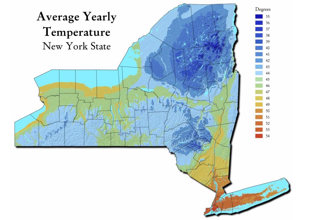
Map: Average Yearly Temperature
Download a High Resolution JPEG Image of the Average Yearly Temperature or an Adobe Acrobat Printable PDF of the Average Yearly Temperature.
About Map: Average Yearly Temperature ....
See also the interactive map: https://andyarthur.org/google-maps-average-yearly-temperature-in-new-york.html
Data Source: This coverage contains data representing areas (polygons) of Average Temperature for the period 1971-2000. From the PRISM Group at Oregon State University. https://datagateway.nrcs.usda.gov/GDGOrder.aspx?order=QuickState

Bookmark my free Interactive GPS Map for your phone:
https://andyarthur.org/ny
... shows your location as a blue dot in relationship to campsites, trails, state land. This online map requires cell service, won't work in remote country, so also bring a paper map.
Free Download of New & Historical USGS 1:24k Topograpic Maps
Interactive maps with backcountry and roadside camping: New York, Pennsylvania, West Virginia & Vermont. List of NYS DEC Lean-Tos and Firetowers.
Google Spreadsheet with Roadside, Primitive and Pay Campsites
More about Winter...
Maps and Interactives
While we had some breaks of sun today
Warm up coming?
Tonight from NOAA Suomi
Terra Satellite – March 9, 2020 vs March 5, 2021
Terra – January 21, 2022
Terra – December 9, 2021
Terra – December 14, 2021
Snow Depth – Upstate NY
Snow Accumulation
Saturday March 13 and 20, 2021
Radar and Sky Cover
November 27, 2021 – Snow in the high peaks
Nice clear day today
MODIS Terra – November 22, 2022
MODIS Terra – November 20, 2022
MODIS Terra – November 18, 2022
MODIS Terra – March 30, 2023
MODIS Terra – January 8, 2024
MODIS Terra – February 13, 2023
MODIS Aqua – Thursday, January 26, 2023
MODIS Aqua – March 9, 2023
MODIS Aqua – December 26, 2021
March 13, 2023 Snowstorm Approaches
Looks like the snow is pulling off
Lake Effect Starts Building – January 10, 2022
... photos, maps and other content from from Winter.