Map: Sand Flats State Forest

Download a High Resolution JPEG Image of the Sand Flats State Forest or an Adobe Acrobat Printable PDF of the Sand Flats State Forest.

Bookmark my free Interactive GPS Map for your phone:
https://andyarthur.org/ny
... shows your location as a blue dot in relationship to campsites, trails, state land. This online map requires cell service, won't work in remote country, so also bring a paper map.
Free Download of New & Historical USGS 1:24k Topograpic Maps
Interactive maps with backcountry and roadside camping: New York, Pennsylvania, West Virginia & Vermont. List of NYS DEC Lean-Tos and Firetowers.
Google Spreadsheet with Roadside, Primitive and Pay Campsites
More about Sand Flats State Forest...
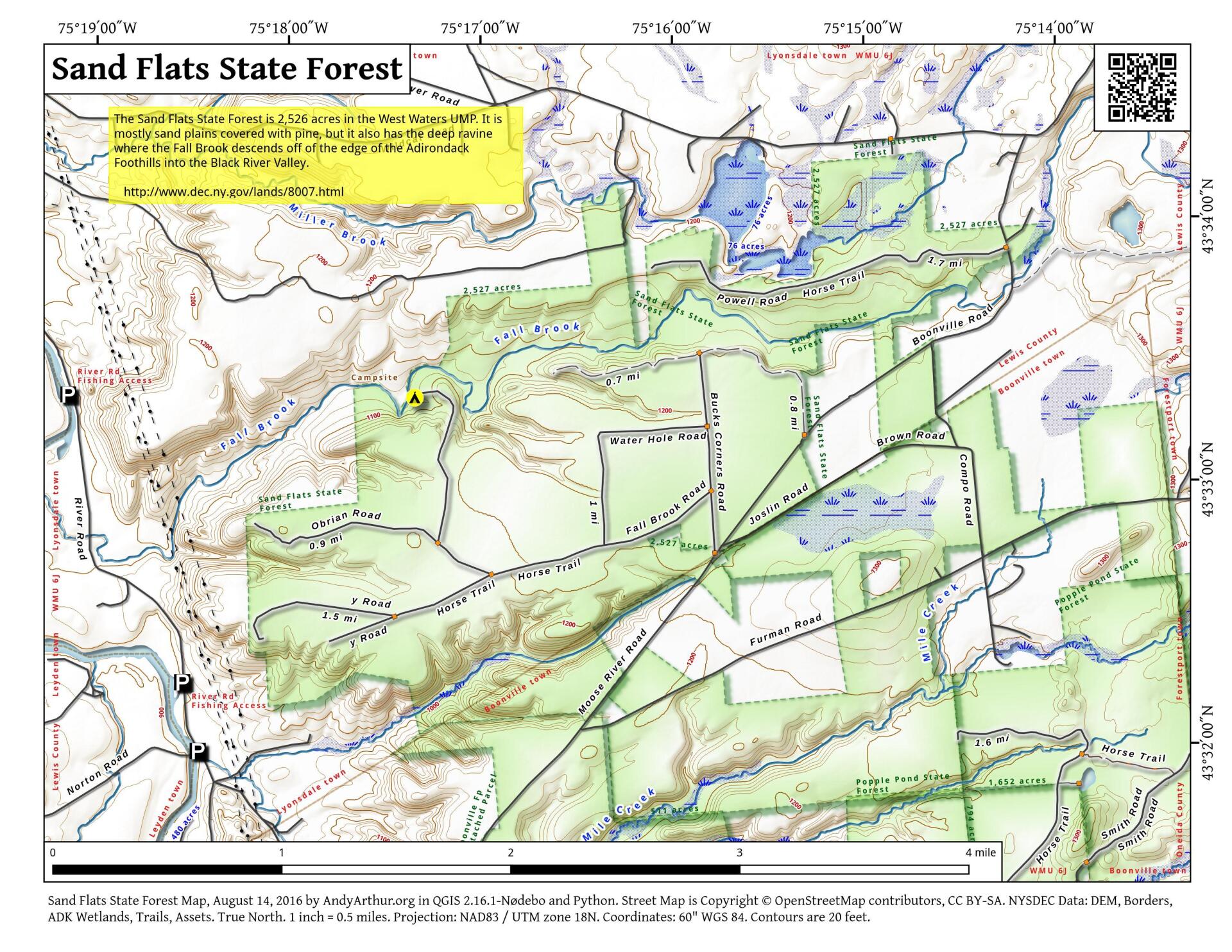
This 2532 acre state forest was purchased by the state in the 1930's. Its name originates from the flat and sandy characteristic of much of area. Historically these well drained "flats" were extensively cultivated for potatoes, which were then shipped to city markets via the Black River Canal. Unfortunately, agricultural practices of the time soon resulted in soil nutrient depletion and eventual agricultural abandonment of the site in favor of more productive soils. Soon after the Conservation Department(now NYSDEC) purchased the property, tree planting crews established miles of soil stabilizing fencing and planted hundreds of thousands of drought tolerant Scotch, red, white, and jack pines in a monumental effort to anchor the shifting sands and rebuild the top soil. The vigorous pine plantations that exist here today are a testimonial to the efforts of these dedicated crews. These plantations and adjacent natural stands of quality hardwoods and spruce/fir are periodically thinned for improvement by private timber contractors under the direction of DEC's professional forestry staff.
Fall Brook, a popular trout fishing stream, flows from east to west through the middle of this forest. Other recreational pursuits on the area include white-tailed deer, turkey, and other small game hunting, horseback riding, and woodland hiking and biking. Access to the area is provided by a network of 5.7 miles of forest access roads beginning at Bucks Corners on the Moose River Road. Access to the forest north of Fall Brook is provided by Powell Road (1.7 miles). Fall Brook Crest Trail (0.7 miles) provides motorized access by permit only (MAPPWD).
http://www.dec.ny.gov/lands/8007.html
... photos, maps and other content from from Lewis County.
2 Comments
Is this the area where the novel “Burt Breen’s Barn” by Walter Edmonds is set?
I don’t know