Search Results for: cherry valley ny

Cherry Valley Bypass

Back in the early 1950s, Cherry Valley was bypassed by US Route 20, with a new four lane limited-access arterial. The former alignment is now County Route 54 which runs from the Teepee to East Springfield. The traditional topographic maps don't show the new alignment of US 20.
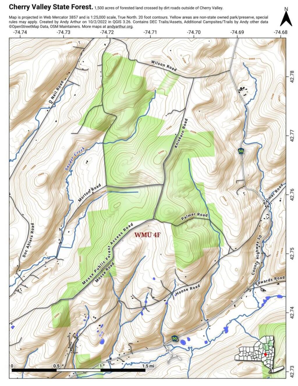
USGS Topographic Maps – Albany to Delaware Counties

Counties: Albany to Delaware / Dutchess to Livingston / Madison to Otsego / Putnam to Suffolk / Sullivan to Yates

Browse Topographic Maps: Full State / Historical USGS Topographic Maps

Albany County

PDF (50-60 MB Download) Historical USGS Topo Maps State Lands (Links to DEC Website) Towns (Percent of Town’s Area)
Current Albany GeoPDF Map
1953 Map No. 136552, 1953 Map No. 136553, 1953 Map No. 136559, 1978 Map No. 136558, 1994 Map No. 137061 Albany Pine Bush Preserve Albany city (85%), Bethlehem (14%), Colonie (41%), Guilderland (7%), New Scotland (2%), Rensselaer city (3%)
Current Alcove GeoPDF Map
1953 Map No. 136571, 1953 Map No. 136572, 1953 Map No. 136573 Coxsackie FP Detached Parcel, Greenville FP Detached Parcel Coeymans (33%), Coxsackie (6%), Greenville (30%), New Baltimore (39%), Westerlo (12%)
Current Altamont GeoPDF Map
1944 Map No. 136597, 1944 Map No. 136598, 1944 Map No. 136599, 1944 Map No. 136602 Margaret Burke WMA Berne (12%), Duanesburg (3%), Guilderland (30%), Knox (60%), New Scotland (4%), Princetown (1%)
Current Clarksville GeoPDF Map
1953 Map No. 137631, 1953 Map No. 137632, 1953 Map No. 137633, 1953 Map No. 137634 Five Rivers Environmental Education Center, Louise E. Keir WMA Bethlehem (4%), Coeymans (24%), New Scotland (62%), Westerlo (7%)
Current Delmar GeoPDF Map
1953 Map No. 137861, 1953 Map No. 137862, 1953 Map No. 137863, 1953 Map No. 137865, 1953 Map No. 137866, 1978 Map No. 137864 Coeymans Creek WMA, Onesquethaw Creek Fishing Access Albany city (2%), Bethlehem (81%), Coeymans (19%), East Greenbush (5%), New Scotland (0%), Rensselaer city (8%), Schodack (4%)
Current Durham GeoPDF Map
1945 Map No. 137938, 1946 Map No. 137933, 1946 Map No. 137934, 1967 Map No. 137937 Catskill Creek Fishing Access, Mount Hayden State Forest, Mount Pisgah State Forest, Scott Patent State Forest, Rensselaerville State Forest Broome (4%), Conesville (0%), Durham (36%), Rensselaerville (57%), Windham (0%)
Current Gallupville GeoPDF Map
1944 Map No. 137216, 1944 Map No. 138096, 1944 Map No. 138097 Dutch Settlement State Forest Berne (3%), Duanesburg (16%), Knox (40%), Schoharie (2%), Wright (83%)
Current Greenville GeoPDF Map
1945 Map No. 129624, 1945 Map No. 129625, 1946 Map No. 129626, 1980 Map No. 129627 NA Durham (16%), Greenville (42%), Rensselaerville (11%), Westerlo (41%)
Current Livingstonville GeoPDF Map
1945 Map No. 130298, 1945 Map No. 130301, 1946 Map No. 130299, 1962 Map No. 130300 South Mountain State Forest, Mount Pisgah State Forest, Stone Store State Forest, Keyserkill State Forest, Scott Patent State Forest, High Knob State Forest, Leonard Hill State Forest, Dutton Ridge State Forest, Bates State Forest Broome (42%), Conesville (64%), Durham (0%), Gilboa (13%), Rensselaerville (2%), Windham (0%)
Current Niskayuna GeoPDF Map
1954 Map No. 128733, 1954 Map No. 128734, 1954 Map No. 128735, 1954 Map No. 137464 NA Clifton Park (58%), Colonie (22%), Halfmoon (17%), Niskayuna (48%)
Current Ravena GeoPDF Map
1953 Map No. 136024, 1953 Map No. 136025, 1953 Map No. 136026 Bronck Island, Hannacroix Unique Area, Van Schaak Unique Area, New Baltimore FP Detached Parcel, Nutten Hook State Tidal Wetland, Coeymans Creek WMA Coeymans (25%), Coxsackie (3%), New Baltimore (61%), Schodack (7%), Stuyvesant (38%)
Current Rensselaerville GeoPDF Map
1946 Map No. 136056, 1946 Map No. 136057 Dutch Settlement State Forest, Rensselaerville State Forest, Partridge Run State Forest, Partridge Run WMA Berne (42%), Broome (9%), Middleburgh (12%), Rensselaerville (26%), Wright (5%)
Current Schenectady GeoPDF Map
1954 Map No. 129430, 1954 Map No. 129431, 1954 Map No. 129433, 1954 Map No. 129434 Albany Pine Bush Preserve Clifton Park (4%), Colonie (4%), Glenville (32%), Guilderland (3%), Niskayuna (52%), Princetown (0%), Rotterdam (36%), Schenectady city (100%)
Current Troy North GeoPDF Map
1954 Map No. 139377, 1954 Map No. 139378, 1954 Map No. 139379, 1954 Map No. 139381, 1978 Map No. 139380 NA Brunswick (12%), Cohoes city (100%), Colonie (12%), Green Island (42%), Halfmoon (45%), Schaghticoke (23%), Troy city (30%), Waterford (100%)
Current Troy South GeoPDF Map
1953 Map No. 139382, 1953 Map No. 139383, 1953 Map No. 139384, 1953 Map No. 139386, 1953 Map No. 139387, 1978 Map No. 139385 NA Albany city (8%), Brunswick (12%), Colonie (18%), East Greenbush (28%), Green Island (58%), North Greenbush (91%), Rensselaer city (84%), Sand Lake (1%), Troy city (70%), Watervliet city (100%)
Current Voorheesville GeoPDF Map
1954 Map No. 139503, 1954 Map No. 139504, 1954 Map No. 139505 Albany Pine Bush Preserve, Black Creek Marsh WMA Albany city (4%), Bethlehem (0%), Colonie (3%), Guilderland (59%), New Scotland (30%)
Current Westerlo GeoPDF Map
1943 Map No. 137019, 1943 Map No. 140234, 1943 Map No. 140235 Cole Hill State Forest, Partridge Run WMA Berne (43%), New Scotland (3%), Rensselaerville (3%), Westerlo (40%)

Allegany County

PDF (50-60 MB Download) Historical USGS Topo Maps State Lands (Links to DEC Website) Towns (Percent of Town’s Area)
Current Alfred GeoPDF Map
1964 Map No. 136588, 1964 Map No. 136589, 1964 Map No. 136590 Phillips Creek State Forest, Hiltonville State Forest, Palmer’s Pond State Forest, Karr Valley Creek State Forest, Turnpike State Forest, Bully Hill State Forest, Klipnocky State Forest Alfred (33%), Almond (63%), Birdsall (9%), Ward (5%), West Almond (30%)
Current Allentown GeoPDF Map
1965 Map No. 136592, 1965 Map No. 137063 Alma Pond Alma (63%), Bolivar (43%), Scio (24%), Wellsville (4%), Wirt (19%)
Current Andover GeoPDF Map
1965 Map No. 136637, 1965 Map No. 137077 Vandermark State Forest, Phillips Creek State Forest Alfred (56%), Andover (70%), Ward (25%), Wellsville (8%)
Current Angelica GeoPDF Map
1964 Map No. 136644, 1964 Map No. 136645, 1964 Map No. 136646 Coyle Hill State Forest, Allen Lake State Forest Allen (20%), Amity (8%), Angelica (63%), Belfast (43%), Caneadea (13%), Friendship (5%)
Current Arkport GeoPDF Map
1965 Map No. 136691, 1965 Map No. 136692, 1965 Map No. 136693 NA Almond (4%), Burns (22%), Dansville (62%), Fremont (24%), Hornell city (10%), Hornellsville (14%), Ossian (7%)
Current Belmont GeoPDF Map
1965 Map No. 123245, 1965 Map No. 123246 Coyle Hill State Forest Amity (58%), Friendship (38%), Scio (36%), Wellsville (1%), Wirt (24%)
Current Birdsall GeoPDF Map
1964 Map No. 123309, 1964 Map No. 123311 English Hill State Forest, Gillies Hill State Forest, Keeney Swamp State Forest, Gas Springs State Forest, Rattlesnake Hill WMA, Keeney Swamp WMA Allen (26%), Birdsall (48%), Granger (32%), Grove (55%)
Current Black Creek GeoPDF Map
1964 Map No. 123312, 1964 Map No. 123313, 1964 Map No. 137111 Crab Hollow State Forest, Rush Creek State Forest, Hanging Bog WMA – Showy Lady Slipper, Hanging Bog WMA Belfast (57%), Caneadea (17%), Cuba (6%), Friendship (7%), New Hudson (50%), Rushford (15%)
Current Bliss GeoPDF Map
1966 Map No. 123318, 1966 Map No. 123319 Lost Nation State Forest Arcade (43%), Centerville (13%), Eagle (50%), Freedom (12%), Java (9%), Wethersfield (10%)
Current Bolivar GeoPDF Map
1965 Map No. 123114, 1965 Map No. 123338 NA Bolivar (57%), Clarksville (22%), Genesee (50%), Wirt (25%)
Current Canaseraga GeoPDF Map
1964 Map No. 122771 Ossian State Forest, Canaseraga State Forest, Hiltonville State Forest, Klipnocky State Forest, Gas Springs State Forest, Slader Creek State Forest, Rattlesnake Hill WMA, Keeney Swamp WMA Almond (21%), Birdsall (21%), Burns (78%), Grove (24%), Ossian (22%)
Current Cuba GeoPDF Map
1961 Map No. 137759, 1961 Map No. 137760, 1961 Map No. 137761, 1961 Map No. 137762 NA Clarksville (28%), Cuba (43%), Hinsdale (48%), Ischua (28%), Oil Springs Reservation (100%), Oil Springs Reservation (100%), Portville (3%)
Current Fillmore GeoPDF Map
1964 Map No. 138145, 1964 Map No. 138146 English Hill State Forest, Allen Lake State Forest Allen (43%), Caneadea (30%), Granger (50%), Hume (33%)
Current Freedom GeoPDF Map
1963 Map No. 137211, 1963 Map No. 137212, 1963 Map No. 138173 Lost Nation State Forest, Bush Hill State Forest, Farmersville State Forest, Harwood Lake Mua Centerville (37%), Farmersville (30%), Freedom (37%), Rushford (35%)
Current Friendship GeoPDF Map
1965 Map No. 138182, 1965 Map No. 138183 NA Clarksville (28%), Cuba (44%), Friendship (50%), Wirt (31%)
Current Greenwood GeoPDF Map
1965 Map No. 129641, 1965 Map No. 129642, 1978 Map No. 129643 Rock Creek State Forest, Greenwood State Forest Alfred (6%), Andover (4%), Canisteo (0%), Greenwood (67%), Hartsville (66%)
Current Hornell GeoPDF Map
1965 Map No. 129772, 1965 Map No. 129773, 1978 Map No. 129771 Canacadea State Forest, Bully Hill State Forest Alfred (4%), Almond (11%), Fremont (4%), Hartsville (33%), Hornell city (90%), Hornellsville (75%)
Current Houghton GeoPDF Map
1964 Map No. 129789, 1964 Map No. 129790, 1978 Map No. 129788 Lost Nation State Forest, Swift Hill State Forest Caneadea (39%), Centerville (38%), Hume (39%), Rushford (35%)
Current Nunda GeoPDF Map
1943 Map No. 128828, 1972 Map No. 128834, 1972 Map No. 137474 Rattlesnake Hill WMA Castile (1%), Granger (9%), Grove (15%), Mount Morris (12%), Nunda (70%), Portage (54%)
Current Ossian GeoPDF Map
1943 Map No. 135910, 1972 Map No. 135911 Ossian State Forest, Canaseraga State Forest, Rattlesnake Hill WMA Grove (6%), Mount Morris (3%), Nunda (30%), Ossian (54%), West Sparta (55%)
Current Pike GeoPDF Map
1943 Map No. 128996, 1972 Map No. 128998, 1972 Map No. 136801 Wiscoy Creek Fishing Access, Lost Nation State Forest, Cold Creek State Forest Centerville (13%), Eagle (50%), Gainesville (10%), Hume (13%), Pike (64%), Wethersfield (9%)
Current Portageville GeoPDF Map
1943 Map No. 129125, 1972 Map No. 129128, 1972 Map No. 129129, 1972 Map No. 129131 East Koy Creek Fishing Access, Wiscoy Creek Fishing Access, Genesee Valley WMA Castile (11%), Gainesville (8%), Genesee Falls (100%), Granger (10%), Hume (15%), Mount Morris (0%), Pike (36%), Portage (46%)
Current Portville GeoPDF Map
1961 Map No. 129134, 1961 Map No. 129135, 1961 Map No. 136828 NA Clarksville (22%), Genesee (50%), Portville (82%)
Current Rawson GeoPDF Map
1963 Map No. 136027, 1963 Map No. 136028 Crab Hollow State Forest, Bush Hill State Forest, Hanging Bog WMA Cuba (6%), Farmersville (13%), Ischua (8%), Lyndon (61%), New Hudson (50%), Rushford (15%)
Current Rexville GeoPDF Map
1965 Map No. 136058, 1965 Map No. 136059 NA Andover (1%), Greenwood (25%), Independence (2%), Troupsburg (5%), West Union (100%)
Current Wellsville North GeoPDF Map
1965 Map No. 137002, 1965 Map No. 140121, 1965 Map No. 140122 Vandermark State Forest, Phillips Creek State Forest, Plumbottom State Forest Amity (30%), Andover (4%), Scio (41%), Ward (60%), Wellsville (32%)
Current Wellsville South GeoPDF Map
1965 Map No. 140123, 1965 Map No. 140124 Wag Trail, Alma Pond, Genesee River Wildlife Management Area Alma (37%), Wellsville (47%), Willing (70%)
Current West Almond GeoPDF Map
1964 Map No. 140125, 1964 Map No. 140126 Jersey Hill State Forest, Phillips Creek State Forest, Hiltonville State Forest, Palmer’s Pond State Forest, Karr Valley Creek State Forest, Turnpike State Forest, Gillies Hill State Forest, Bald Mountain State Forest Allen (12%), Amity (4%), Angelica (37%), Birdsall (22%), Ward (11%), West Almond (70%)
Current Whitesville GeoPDF Map
1965 Map No. 137029, 1965 Map No. 140293 Wag Trail Andover (21%), Independence (98%), Wellsville (9%), Willing (30%)

Bronx County

PDF (50-60 MB Download) Historical USGS Topo Maps State Lands (Links to DEC Website) Towns (Percent of Town’s Area)
Current Central Park GeoPDF Map
1947 Map No. 122894, 1956 Map No. 122895, 1956 Map No. 122896, 1966 Map No. 122897, 1966 Map No. 122898, 1966 Map No. 122899, 1966 Map No. 122900, 1995 Map No. 137165 Bronx River Trail Bronx borough (31%), Manhattan borough (68%), Queens borough (7%)
Current Flushing GeoPDF Map
1947 Map No. 138246, 1947 Map No. 138247, 1955 Map No. 138248, 1955 Map No. 138249, 1966 Map No. 137330, 1966 Map No. 138250, 1966 Map No. 138251, 1966 Map No. 138252, 1995 Map No. 137332 Bronx River Trail Bronx borough (42%), North Hempstead (2%), Queens borough (17%)
Current Mount Vernon GeoPDF Map
1956 Map No. 130718, 1956 Map No. 130719, 1966 Map No. 130720, 1966 Map No. 130721, 1966 Map No. 130722, 1966 Map No. 130723, 1995 Map No. 137393 Titus Mill Pond State Tidal Wetland Bronx borough (13%), Eastchester (100%), Greenburgh (11%), Mamaroneck (48%), Mount Vernon city (100%), New Rochelle city (100%), Pelham (100%), Scarsdale (74%), White Plains city (2%), Yonkers city (60%)
Current Yonkers GeoPDF Map
1966 Map No. 140393, 1966 Map No. 140394, 1998 Map No. 137051 NA Bronx borough (14%), Greenburgh (5%), Manhattan borough (1%), Orangetown (0%), Yonkers city (40%)

Broome County

PDF (50-60 MB Download) Historical USGS Topo Maps State Lands (Links to DEC Website) Towns (Percent of Town’s Area)
Current Afton GeoPDF Map
1957 Map No. 136536, 1957 Map No. 136537, 1957 Map No. 136538, 1957 Map No. 137055 Beaver Pond State Forest, Melondy Hill State Forest, Marsh Pond State Forest, Susquehanna River Boat Launch Afton (49%), Colesville (28%), Coventry (3%), Sanford (10%), Windsor (0%)
Current Belden GeoPDF Map
1957 Map No. 123233 Beaver Flow State Forest Afton (3%), Colesville (62%), Coventry (2%), Fenton (9%), Greene (0%), Windsor (1%)
Current Binghamton East GeoPDF Map
1937 Map No. 123290, 1937 Map No. 123291, 1961 Map No. 123294, 1968 Map No. 123295, 1968 Map No. 123296 Kirkwood Sub-Office, Skyline Drive State Forest Binghamton city (9%), Binghamton (8%), Conklin (98%), Kirkwood (73%), Windsor (7%)
Current Binghamton West GeoPDF Map
1935 Map No. 123297, 1961 Map No. 123299, 1968 Map No. 123300, 1968 Map No. 123301, 1968 Map No. 137107 NA Binghamton city (89%), Binghamton (92%), Conklin (2%), Dickinson (25%), Kirkwood (0%), Union (10%), Vestal (33%)
Current Castle Creek GeoPDF Map
1934 Map No. 122840, 1942 Map No. 122841, 1961 Map No. 122846, 1968 Map No. 122847, 1968 Map No. 122848 NA Barker (12%), Binghamton city (2%), Chenango (72%), Dickinson (75%), Fenton (4%), Kirkwood (0%), Maine (26%), Nanticoke (5%), Union (20%)
Current Chenango Forks GeoPDF Map
1935 Map No. 122947, 1942 Map No. 122948, 1960 Map No. 122954, 1968 Map No. 122955, 1968 Map No. 122956 NA Barker (3%), Chenango (28%), Colesville (9%), Fenton (87%), Greene (1%), Kirkwood (24%), Windsor (0%)
Current Deposit GeoPDF Map
1965 Map No. 137205, 1965 Map No. 137880 Oquaga Creek Fishing Access, Lower West Branch Delaware River Fishing Access, West Branch Delaware River Waterway Access, Oquaga Creek Fishing Access, Columbia Lake State Forest, Michigan Hill State Forest, Whitaker Swamp State Forest, Cat Hollow State Forest, West Branch Delaware River Deposit (41%), Sanford (41%)
Current Endicott GeoPDF Map
1956 Map No. 138228, 1956 Map No. 138229, 1969 Map No. 137326, 1969 Map No. 138234, 1969 Map No. 138235 Tracy Creek State Forest Owego (7%), Union (37%), Vestal (67%)
Current Greene GeoPDF Map
1948 Map No. 129612, 1950 Map No. 129613 NA Barker (19%), Greene (58%), Triangle (9%)
Current Gulf Summit GeoPDF Map
1952 Map No. 129660, 1952 Map No. 129661, 1952 Map No. 129662, 1952 Map No. 129663 Beaver Pond State Forest, Marsh Pond State Forest, Cascade Valley State Forest Colesville (1%), Sanford (27%), Windsor (33%)
Current Lisle GeoPDF Map
1949 Map No. 130273, 1949 Map No. 130275, 1951 Map No. 130274 Ketchumville State Forest, Nanticoke Lake Multiple Use Area Berkshire (13%), Lisle (56%), Maine (5%), Nanticoke (73%), Newark Valley (7%), Richford (4%)
Current Maine GeoPDF Map
1956 Map No. 130418, 1956 Map No. 130419, 1969 Map No. 130420, 1969 Map No. 130421, 1969 Map No. 137425 Ketchumville State Forest, Nanticoke Creek Fishing Access Maine (69%), Nanticoke (2%), Newark Valley (18%), Owego (2%), Union (33%)
Current Marathon GeoPDF Map
1950 Map No. 130449, 1950 Map No. 130450, 1950 Map No. 130451, 1950 Map No. 130452, 1950 Map No. 137432 Beaver Dam State Forest, Hoxie Gorge State Forest, James Kennedy State Forest Freetown (13%), Lapeer (66%), Lisle (34%), Marathon (62%), Richford (1%), Virgil (8%)
Current North Sanford GeoPDF Map
1965 Map No. 128768, 1965 Map No. 128769 Arctic China State Forest, Beals Pond State Forest, Michigan Hill State Forest, Steam Mill State Forest, Beaver Pond State Forest, Melondy Hill State Forest Afton (33%), Bainbridge (2%), Deposit (13%), Masonville (25%), Sanford (22%)
Current Smithville Flats GeoPDF Map
1948 Map No. 136183, 1948 Map No. 136184, 1948 Map No. 136185 Genegantslet Creek Fishing Access, Triangle State Forest, Red Brook State Forest, Long Pond State Forest, Genegantslet State Forest, Five Streams State Forest Cincinnatus (1%), German (53%), Greene (4%), McDonough (14%), Smithville (53%), Triangle (5%), Willet (8%)
Current Whitney Point GeoPDF Map
1949 Map No. 137030, 1949 Map No. 140294, 1949 Map No. 140295, 1951 Map No. 140296 Triangle State Forest Barker (66%), Lisle (7%), Nanticoke (20%), Triangle (49%)
Current Willet GeoPDF Map
1949 Map No. 140297, 1951 Map No. 140298 Papish Pond Multiple Use Area, Triangle State Forest Cincinnatus (15%), Freetown (6%), Lisle (4%), Marathon (38%), Triangle (37%), Willet (92%)
Current Windsor GeoPDF Map
1952 Map No. 140350, 1952 Map No. 140351, 1952 Map No. 140352 Skyline Drive State Forest, Hawkins Pond State Forest, Susquehanna Waterway Access Colesville (1%), Kirkwood (2%), Windsor (59%)

Cattaraugus County

PDF (50-60 MB Download) Historical USGS Topo Maps State Lands (Links to DEC Website) Towns (Percent of Town’s Area)
Current Arcade GeoPDF Map
1966 Map No. 136682, 1966 Map No. 136683 NA Arcade (57%), Freedom (12%), Holland (7%), Java (12%), Sardinia (19%), Yorkshire (14%)
Current Ashford GeoPDF Map
1964 Map No. 136703 Boyce Hill State Forest, Bryant Hill State Forest, Golden Hill State Forest Ellicottville (37%), Franklinville (50%), Great Valley (3%), Humphrey (9%), Machias (19%)
Current Ashford Hollow GeoPDF Map
1964 Map No. 136700, 1964 Map No. 136701, 1964 Map No. 136702, 1964 Map No. 710169 NA Ashford (64%), Concord (9%), East Otto (36%), Ellicottville (2%)
Current Bliss GeoPDF Map
1966 Map No. 123318, 1966 Map No. 123319 Lost Nation State Forest Arcade (43%), Centerville (13%), Eagle (50%), Freedom (12%), Java (9%), Wethersfield (10%)
Current Cattaraugus GeoPDF Map
1963 Map No. 122868, 1963 Map No. 122869, 1963 Map No. 137161 Mansfield Creek Fishing Access, Cattaraugus State Forest, Dobbins Memorial State Forest East Otto (8%), Little Valley (8%), Mansfield (59%), Napoli (5%), New Albion (42%), Otto (27%), Persia (1%)
Current Cherry Creek GeoPDF Map
1954 Map No. 122963, 1954 Map No. 122964, 1954 Map No. 137172 NA Cherry Creek (55%), Conewango (6%), Dayton (16%), Ellington (7%), Leon (52%), Villenova (17%)
Current Collins Center GeoPDF Map
1963 Map No. 137682, 1963 Map No. 137683, 1963 Map No. 137684 Cattaraugus Creek Waterway Access, Zoar Valley Multiple Use Area, Zoar Valley Unique Area, East Otto State Forest Collins (35%), Concord (5%), East Otto (37%), Otto (61%)
Current Cuba GeoPDF Map
1961 Map No. 137759, 1961 Map No. 137760, 1961 Map No. 137761, 1961 Map No. 137762 NA Clarksville (28%), Cuba (43%), Hinsdale (48%), Ischua (28%), Oil Springs Reservation (100%), Oil Springs Reservation (100%), Portville (3%)
Current Delevan GeoPDF Map
1963 Map No. 137977, 1963 Map No. 137978, 1963 Map No. 137979 Lime Lake Outlet Fishing Access, Bush Hill State Forest, Harwood Lake Mua Farmersville (41%), Freedom (39%), Machias (23%), Yorkshire (28%)
Current Ellicottville GeoPDF Map
1964 Map No. 138205, 1964 Map No. 138206 Poverty Hill WMA, Dobbins Memorial State Forest, Mccarty Hill State Forest East Otto (19%), Ellicottville (59%), Great Valley (5%), Little Valley (6%), Mansfield (41%)
Current Farnham GeoPDF Map
1960 Map No. 138142, 1960 Map No. 138143 NA Brant (61%), Cattaraugus Reservation (54%), Cattaraugus Reservation (49%), Cattaraugus Reservation (100%), Evans (13%), Hanover (20%), Perrysburg (17%)
Current Franklinville GeoPDF Map
1963 Map No. 138165, 1963 Map No. 138166 Ischua Creek Fishing Access, Bear Creek State Forest, Bush Hill State Forest, Golden Hill State Forest Farmersville (17%), Franklinville (50%), Humphrey (4%), Ischua (11%), Lyndon (39%), Machias (8%)
Current Freedom GeoPDF Map
1963 Map No. 137211, 1963 Map No. 137212, 1963 Map No. 138173 Lost Nation State Forest, Bush Hill State Forest, Farmersville State Forest, Harwood Lake Mua Centerville (37%), Farmersville (30%), Freedom (37%), Rushford (35%)
Current Gowanda GeoPDF Map
1963 Map No. 129589, 1963 Map No. 129590 Zoar Valley Multiple Use Area, Zoar Valley Unique Area Cattaraugus Reservation (39%), Cattaraugus Reservation (8%), Collins (25%), Dayton (33%), Otto (11%), Perrysburg (30%), Persia (69%)
Current Hinsdale GeoPDF Map
1961 Map No. 129865, 1971 Map No. 129864, 1979 Map No. 129863 NA Allegany (9%), Hinsdale (52%), Humphrey (27%), Ischua (53%), Olean (5%), Portville (1%)
Current Humphrey GeoPDF Map
1961 Map No. 129943, 1961 Map No. 129944, 1961 Map No. 129945, 1961 Map No. 137268 Nine Mile Creek State Forest, Raecher Hill State Forest, Golden Hill State Forest, Windfall Creek State Forest Allegany (19%), Carrollton (0%), Great Valley (38%), Humphrey (60%)
Current Ivory GeoPDF Map
1954 Map No. 129956, 1954 Map No. 129957, 1954 Map No. 129958, 1954 Map No. 137278 South Valley State Forest Carroll (60%), Poland (24%), Randolph (23%), South Valley (50%)
Current Kennedy GeoPDF Map
1954 Map No. 130016, 1954 Map No. 130017, 1954 Map No. 130019, 1979 Map No. 130018 Harris Hill State Forest, Conewango Swamp WMA Conewango (45%), Ellington (48%), Poland (31%), Randolph (28%)
Current Knapp Creek GeoPDF Map
1961 Map No. 130138, 1961 Map No. 130139, 1979 Map No. 130140 Nine Mile Creek State Forest, Birch Run Ponds Fwma Allegany Reservation (9%), Allegany (49%), Carrollton (39%)
Current Limestone GeoPDF Map
1961 Map No. 130267, 1961 Map No. 130268, 1961 Map No. 137359, 1961 Map No. 137360 Windfall Creek State Forest Allegany Reservation (15%), Carrollton (60%), Red House (43%)
Current Little Valley GeoPDF Map
1962 Map No. 130285, 1962 Map No. 130286, 1962 Map No. 130287, 1962 Map No. 130288, 1962 Map No. 137364 Bucktooth State Forest, Elkdale State Forest Allegany Reservation (13%), Coldspring (16%), Little Valley (50%), Napoli (37%), Red House (2%), Salamanca city (9%), Salamanca (60%)
Current New Albion GeoPDF Map
1963 Map No. 130784, 1963 Map No. 137402 Conewango Creek Waterway Access Conewango (6%), Dayton (15%), Leon (48%), Napoli (7%), New Albion (58%), Otto (1%), Persia (30%)
Current North Collins GeoPDF Map
1960 Map No. 128742, 1960 Map No. 128743 NA Brant (39%), Cattaraugus Reservation (7%), Cattaraugus Reservation (41%), Collins (17%), Eden (10%), Evans (8%), North Collins (43%), Perrysburg (4%)
Current Olean GeoPDF Map
1961 Map No. 128897, 1961 Map No. 128898, 1961 Map No. 128899 NA Allegany (23%), Olean city (100%), Olean (95%), Portville (14%)
Current Perrysburg GeoPDF Map
1954 Map No. 128964, 1954 Map No. 128965, 1954 Map No. 128966, 1954 Map No. 136790 NA Dayton (36%), Hanover (29%), Perrysburg (49%), Villenova (38%)
Current Portville GeoPDF Map
1961 Map No. 129134, 1961 Map No. 129135, 1961 Map No. 136828 NA Clarksville (22%), Genesee (50%), Portville (82%)
Current Randolph GeoPDF Map
1962 Map No. 136010, 1962 Map No. 136011 Randolph Fish Hatchery, Conewango Swamp WMA Allegany Reservation (1%), Coldspring (21%), Conewango (43%), Napoli (51%), Randolph (27%)
Current Rawson GeoPDF Map
1963 Map No. 136027, 1963 Map No. 136028 Crab Hollow State Forest, Bush Hill State Forest, Hanging Bog WMA Cuba (6%), Farmersville (13%), Ischua (8%), Lyndon (61%), New Hudson (50%), Rushford (15%)
Current Red House GeoPDF Map
1962 Map No. 136036, 1962 Map No. 136037, 1962 Map No. 136852, 1962 Map No. 136853 NA Allegany Reservation (21%), Coldspring (33%), Red House (54%)
Current Salamanca GeoPDF Map
1961 Map No. 129323, 1961 Map No. 129324, 1961 Map No. 129325 Mccarty Hill State Forest, Rock City State Forest, Windfall Creek State Forest Allegany Reservation (9%), Carrollton (0%), Great Valley (54%), Little Valley (35%), Red House (1%), Salamanca city (91%), Salamanca (40%)
Current Sardinia GeoPDF Map
1957 Map No. 129402, 1957 Map No. 129403, 1957 Map No. 136888 Cattaraugus Creek Fishing Access Parking Ashford (2%), Colden (8%), Holland (15%), Sardinia (80%), Yorkshire (14%)
Current Steamburg GeoPDF Map
1962 Map No. 139892, 1962 Map No. 139893, 1962 Map No. 139894 Pine Hill State Forest, South Valley State Forest Allegany Reservation (31%), Coldspring (30%), Randolph (22%), South Valley (50%)
Current West Valley GeoPDF Map
1964 Map No. 140223, 1964 Map No. 140224 NA Ashford (34%), Ellicottville (2%), Machias (50%), Yorkshire (44%)

Cayuga County

PDF (50-60 MB Download) Historical USGS Topo Maps State Lands (Links to DEC Website) Towns (Percent of Town’s Area)
Current Auburn GeoPDF Map
1953 Map No. 136737, 1954 Map No. 136738, 1954 Map No. 136739, 1954 Map No. 136743 NA Auburn city (100%), Aurelius (19%), Fleming (38%), Owasco (31%), Sennett (51%), Throop (48%)
Current Cato GeoPDF Map
1954 Map No. 122851, 1954 Map No. 122852, 1954 Map No. 137160 NA Cato (39%), Conquest (13%), Ira (79%), Victory (24%)
Current Cayuga GeoPDF Map
1954 Map No. 122871, 1954 Map No. 122872 Northern Montezuma WMA Aurelius (81%), Fayette (0%), Fleming (3%), Montezuma (40%), Seneca Falls (14%), Springport (26%), Throop (35%), Tyre (10%)
Current Fair Haven GeoPDF Map
1943 Map No. 138121, 1954 Map No. 138123, 1954 Map No. 138124, 1954 Map No. 138125 Lake Shore Marshes WMA Sterling (76%), Victory (1%), Wolcott (25%)
Current Genoa GeoPDF Map
1942 Map No. 129506, 1970 Map No. 129510, 1970 Map No. 137221 NA Genoa (57%), Lansing (0%), Ledyard (1%), Venice (72%)
Current Groton GeoPDF Map
1942 Map No. 129649, 1942 Map No. 129650, 1970 Map No. 129654, 1970 Map No. 137236 NA Cortlandville (7%), Dryden (21%), Groton (58%), Locke (1%), Summerhill (4%), Virgil (4%)
Current Hannibal GeoPDF Map
1943 Map No. 129704, 1954 Map No. 129707, 1954 Map No. 129708, 1978 Map No. 129709 NA Granby (4%), Hannibal (92%), Ira (5%), Oswego (8%), Sterling (14%), Victory (1%)
Current Jordan GeoPDF Map
1955 Map No. 130109, 1955 Map No. 130110, 1978 Map No. 130111, 1978 Map No. 130112 Cold Brook Parking Area, Carpenter’s Creek Fishing Access, Cross Lake Islands WMA, Cross Lake Waterway Access Brutus (5%), Camillus (0%), Cato (5%), Elbridge (99%), Lysander (4%), Sennett (3%), Skaneateles (5%), Van Buren (19%)
Current Lysander GeoPDF Map
1955 Map No. 130408, 1955 Map No. 130409, 1955 Map No. 137424 Three Rivers WMA Cato (13%), Granby (16%), Ira (15%), Lysander (47%), Van Buren (20%)
Current Montezuma GeoPDF Map
1954 Map No. 130619, 1954 Map No. 130620, 1954 Map No. 130621 Northern Montezuma WMA Conquest (41%), Mentz (61%), Montezuma (60%), Savannah (39%), Throop (7%), Tyre (8%)
Current Moravia GeoPDF Map
1943 Map No. 130657, 1943 Map No. 130658, 1971 Map No. 130663, 1971 Map No. 137461 Owasco Flats WMA, Summer Hill State Forest, Owasco Lake Inlet Fishing Access Genoa (18%), Lansing (0%), Locke (85%), Moravia (60%), Venice (20%)
Current Oswego West GeoPDF Map
1954 Map No. 135927, 1954 Map No. 135928, 1954 Map No. 135929, 1954 Map No. 137498 NA Minetto (8%), Oswego city (47%), Oswego (90%), Sterling (3%)
Current Owasco GeoPDF Map
1943 Map No. 135945, 1955 Map No. 135946, 1955 Map No. 135947, 1955 Map No. 135948 Dutch Hollow Brook Parking Area, Frozen Ocean State Forest, Owasco Lake Water Access Moravia (35%), Niles (64%), Owasco (23%), Scipio (7%), Skaneateles (14%), Spafford (1%), Venice (3%)
Current Scipio Center GeoPDF Map
1956 Map No. 136113, 1956 Map No. 136114 NA Fleming (55%), Ledyard (0%), Niles (3%), Owasco (10%), Scipio (90%), Venice (5%)
Current Sempronius GeoPDF Map
1943 Map No. 136135, 1971 Map No. 136136 Grout Brook Fishing Access, Bear Swamp State Forest, Summer Hill State Forest Cortlandville (0%), Homer (9%), Locke (8%), Moravia (4%), Scott (17%), Sempronius (61%), Summerhill (96%)
Current Sheldrake GeoPDF Map
1942 Map No. 136151, 1971 Map No. 136152, 1971 Map No. 136912 NA Covert (7%), Genoa (23%), Ledyard (51%), Ovid (31%), Romulus (11%)
Current Skaneateles GeoPDF Map
1955 Map No. 136178, 1955 Map No. 136179, 1955 Map No. 136180 Skaneateles Lake Boat Launch Owasco (36%), Sennett (35%), Skaneateles (72%), Spafford (4%)
Current Spafford GeoPDF Map
1955 Map No. 139819, 1955 Map No. 139820 Grout Brook Fishing Access, Carpenter Falls Unique Area, Bear Swamp State Forest, Otisco Lake Waterway Access Site Moravia (1%), Niles (33%), Otisco (10%), Scott (8%), Sempronius (39%), Skaneateles (1%), Spafford (60%)
Current Union Springs GeoPDF Map
1955 Map No. 139440, 1955 Map No. 139441, 1955 Map No. 139442 Canoga Marsh WMA Fayette (10%), Fleming (4%), Ledyard (48%), Romulus (0%), Scipio (3%), Springport (74%), Varick (5%), Venice (0%)
Current Victory GeoPDF Map
1954 Map No. 139502 Northern Montezuma WMA Butler (35%), Conquest (30%), Savannah (3%), Sterling (0%), Victory (75%), Wolcott (10%)
Current Weedsport GeoPDF Map
1954 Map No. 136997, 1954 Map No. 140099, 1954 Map No. 140100, 1954 Map No. 140101 Seneca River Boat Launch Brutus (95%), Cato (43%), Conquest (16%), Mentz (39%), Sennett (11%), Throop (11%)
Current West Groton GeoPDF Map
1943 Map No. 140160, 1943 Map No. 140161, 1970 Map No. 140162, 1970 Map No. 140163 NA Dryden (14%), Groton (42%), Lansing (28%), Locke (6%)
Current West Ninemile Point GeoPDF Map
NA NA Sterling (6%)

Chautauqua County

PDF (50-60 MB Download) Historical USGS Topo Maps State Lands (Links to DEC Website) Towns (Percent of Town’s Area)
Current Brocton GeoPDF Map
1954 Map No. 123107, 1954 Map No. 123108 NA Dunkirk (10%), Pomfret (24%), Portland (38%)
Current Cassadaga GeoPDF Map
1954 Map No. 122829, 1954 Map No. 122830, 1954 Map No. 122831 Stockton State Forest, Canadaway Creek WMA, Kabob WMA Arkwright (12%), Charlotte (39%), Gerry (5%), Pomfret (16%), Stockton (58%)
Current Chautauqua GeoPDF Map
1954 Map No. 122944, 1954 Map No. 122945, 1954 Map No. 122946 Whalen Memorial State Forest, Chautauqua Fish Hatchery, Chautauqua Lake Fish And Wildlife Management Area Chautauqua Lake UT (61%), Chautauqua (17%), Ellery (32%), North Harmony (39%), Stockton (0%)
Current Cherry Creek GeoPDF Map
1954 Map No. 122963, 1954 Map No. 122964, 1954 Map No. 137172 NA Cherry Creek (55%), Conewango (6%), Dayton (16%), Ellington (7%), Leon (52%), Villenova (17%)
Current Clymer GeoPDF Map
1954 Map No. 137791, 1954 Map No. 137792, 1954 Map No. 137793 Findley Lake Waterway Access Clymer (17%), French Creek (100%), Mina (44%), Sherman (7%)
Current Dunkirk GeoPDF Map
1954 Map No. 137928, 1954 Map No. 137929, 1954 Map No. 137930 Canadaway Creek Nature Sanctuary, Dunkirk Office, Canadaway Creek WMA Arkwright (27%), Dunkirk city (98%), Dunkirk (85%), Pomfret (52%), Sheridan (27%)
Current Ellery Center GeoPDF Map
1954 Map No. 137319, 1954 Map No. 137356, 1954 Map No. 138079, 1954 Map No. 138080, 1954 Map No. 255475 Chautauqua Lake Fish And Wildlife Management Area Chautauqua Lake UT (7%), Ellery (66%), Ellicott (25%), Gerry (34%), Stockton (5%)
Current Farnham GeoPDF Map
1960 Map No. 138142, 1960 Map No. 138143 NA Brant (61%), Cattaraugus Reservation (54%), Cattaraugus Reservation (49%), Cattaraugus Reservation (100%), Evans (13%), Hanover (20%), Perrysburg (17%)
Current Forestville GeoPDF Map
1954 Map No. 138265, 1954 Map No. 138266, 1954 Map No. 138267 Canadaway Creek WMA Arkwright (43%), Hanover (29%), Sheridan (38%), Villenova (31%)
Current Gerry GeoPDF Map
1954 Map No. 129512, 1954 Map No. 129513, 1954 Map No. 129514, 1954 Map No. 255471 Harris Hill State Forest, Hatch Creek State Forest, Hartson Swamp WMA Ellicott (40%), Ellington (40%), Gerry (53%), Jamestown city (0%), Poland (25%)
Current Hamlet GeoPDF Map
1954 Map No. 129676, 1954 Map No. 137239 Clear Creek Fishing Access, Harris Hill State Forest, Hatch Creek State Forest, Boutwell Hill State Forest, Canadaway Creek WMA Arkwright (19%), Charlotte (61%), Cherry Creek (45%), Ellington (6%), Gerry (8%), Villenova (14%)
Current Hartfield GeoPDF Map
1954 Map No. 129811, 1954 Map No. 129812 Bear Lake Boat Launch, Stockton State Forest Chautauqua Lake UT (3%), Chautauqua (29%), Pomfret (8%), Portland (42%), Stockton (37%)
Current Ivory GeoPDF Map
1954 Map No. 129956, 1954 Map No. 129957, 1954 Map No. 129958, 1954 Map No. 137278 South Valley State Forest Carroll (60%), Poland (24%), Randolph (23%), South Valley (50%)
Current Jamestown GeoPDF Map
1954 Map No. 129975, 1954 Map No. 129976, 1954 Map No. 129979, 1979 Map No. 129978 Clay Pond WMA, Hartson Swamp WMA Busti (9%), Carroll (40%), Ellicott (19%), Jamestown city (72%), Kiantone (100%), Poland (20%)
Current Kennedy GeoPDF Map
1954 Map No. 130016, 1954 Map No. 130017, 1954 Map No. 130019, 1979 Map No. 130018 Harris Hill State Forest, Conewango Swamp WMA Conewango (45%), Ellington (48%), Poland (31%), Randolph (28%)
Current Lakewood GeoPDF Map
1954 Map No. 130206, 1954 Map No. 130207, 1954 Map No. 130208, 1954 Map No. 130209 Wellman Multiple Use Area Busti (87%), Chautauqua Lake UT (27%), Ellery (2%), Ellicott (16%), Jamestown city (27%), North Harmony (2%)
Current North Clymer GeoPDF Map
1954 Map No. 128739, 1954 Map No. 137465, 1954 Map No. 137466 Panama State Forest, Brokenstraw State Forest, Whalen Memorial State Forest, North Harmony State Forest, Alder Bottom WMA, Jacquins Pond WMA Clymer (83%), Harmony (19%), North Harmony (9%), Sherman (37%)
Current North Of Dunkirk GeoPDF Map
NA NA Dunkirk city (2%), Dunkirk (5%), Sheridan (8%)
Current Panama GeoPDF Map
1954 Map No. 135962, 1954 Map No. 136769 Hill Higher State Forest, Panama State Forest, Brokenstraw State Forest, Whalen Memorial State Forest, North Harmony State Forest, Watts WMA Busti (4%), Chautauqua Lake UT (2%), Harmony (81%), North Harmony (40%)
Current Perrysburg GeoPDF Map
1954 Map No. 128964, 1954 Map No. 128965, 1954 Map No. 128966, 1954 Map No. 136790 NA Dayton (36%), Hanover (29%), Perrysburg (49%), Villenova (38%)
Current Ripley GeoPDF Map
1954 Map No. 136075, 1954 Map No. 136076 NA Ripley (35%), Westfield (10%)
Current Sherman GeoPDF Map
1954 Map No. 136157, 1954 Map No. 136916, 1954 Map No. 136918 Chautauqua Gorge State Forest, Whalen Memorial State Forest, Mount Pleasant State Forest Chautauqua (38%), North Harmony (11%), Sherman (46%), Westfield (17%)
Current Silver Creek GeoPDF Map
1943 Map No. 136171, 1960 Map No. 136168, 1960 Map No. 136172 NA Brant (0%), Cattaraugus Reservation (3%), Hanover (22%), Sheridan (27%)
Current South Ripley GeoPDF Map
1954 Map No. 136201, 1954 Map No. 136202, 1954 Map No. 136203 NA Mina (56%), Ripley (65%), Sherman (9%), Westfield (11%)
Current Westfield GeoPDF Map
1954 Map No. 137021, 1954 Map No. 137022, 1954 Map No. 140247, 1954 Map No. 140248, 1954 Map No. 140249 Chatauqua Creek Fishing Access Chautauqua (16%), Portland (20%), Westfield (61%)

Chemung County

PDF (50-60 MB Download) Historical USGS Topo Maps State Lands (Links to DEC Website) Towns (Percent of Town’s Area)
Current Alpine GeoPDF Map
1950 Map No. 136593, 1950 Map No. 136594, 1969 Map No. 136595, 1969 Map No. 136596, 1969 Map No. 137064 Newfield State Forest, Cliffside State Forest, Connecticut Hill WMA Catharine (45%), Cayuta (82%), Newfield (36%), Veteran (7%)
Current Beaver Dams GeoPDF Map
1953 Map No. 123229, 1953 Map No. 123230, 1953 Map No. 137095 Beaver Dams State Forest, Sugar Hill State Forest, Coon Hollow State Forest Catlin (33%), Dix (74%), Hornby (8%), Orange (22%)
Current Big Flats GeoPDF Map
1953 Map No. 123273, 1953 Map No. 123274, 1969 Map No. 123275, 1969 Map No. 123276, 1969 Map No. 123277 Catlin State Forest Big Flats (53%), Catlin (42%), Corning (24%), Hornby (16%)
Current Elmira GeoPDF Map
1953 Map No. 138214, 1953 Map No. 138215, 1969 Map No. 137321, 1969 Map No. 137322, 1969 Map No. 138224 NA Ashland (56%), Big Flats (5%), Elmira city (100%), Elmira (63%), Horseheads (0%), Southport (48%)
Current Erin GeoPDF Map
1954 Map No. 138116, 1969 Map No. 137327, 1969 Map No. 138117 NA Baldwin (5%), Cayuta (14%), Elmira (1%), Erin (91%), Horseheads (18%), Van Etten (2%), Veteran (9%)
Current Horseheads GeoPDF Map
1953 Map No. 129783, 1953 Map No. 129784, 1969 Map No. 129782, 1978 Map No. 129780, 1978 Map No. 129781 NA Big Flats (8%), Catlin (13%), Elmira (1%), Horseheads (82%), Veteran (44%)
Current Montour Falls GeoPDF Map
1950 Map No. 130637, 1950 Map No. 130638, 1950 Map No. 130640, 1950 Map No. 130641, 1961 Map No. 130639 Catharine Creek Fishing Access, Catharine Creek WMA Catharine (39%), Catlin (11%), Dix (17%), Montour (90%), Veteran (40%)
Current Seeley Creek GeoPDF Map
1953 Map No. 136130, 1953 Map No. 136131, 1969 Map No. 136132, 1969 Map No. 136133, 1969 Map No. 136134 Big Flats WMA Big Flats (34%), Caton (29%), Corning (11%), Southport (52%)
Current Van Etten GeoPDF Map
1954 Map No. 139471, 1969 Map No. 139472, 1969 Map No. 139473 NA Baldwin (5%), Barton (11%), Cayuta (0%), Erin (9%), Spencer (25%), Van Etten (75%)
Current Waverly GeoPDF Map
1954 Map No. 140068, 1954 Map No. 140069, 1969 Map No. 136995, 1969 Map No. 140070, 1969 Map No. 140071 Maple Hill State Forest Baldwin (13%), Barton (38%), Chemung (58%)
Current Wellsburg GeoPDF Map
1954 Map No. 140112, 1969 Map No. 140113 Maple Hill State Forest Ashland (44%), Baldwin (77%), Chemung (42%), Elmira (35%)
Current West Danby GeoPDF Map
1950 Map No. 140144, 1950 Map No. 140145, 1969 Map No. 140146, 1969 Map No. 140147 Danby State Forest Cayuta (3%), Danby (23%), Newfield (48%), Spencer (8%), Van Etten (23%)

Chenango County

PDF (50-60 MB Download) Historical USGS Topo Maps State Lands (Links to DEC Website) Towns (Percent of Town’s Area)
Current Afton GeoPDF Map
1957 Map No. 136536, 1957 Map No. 136537, 1957 Map No. 136538, 1957 Map No. 137055 Beaver Pond State Forest, Melondy Hill State Forest, Marsh Pond State Forest, Susquehanna River Boat Launch Afton (49%), Colesville (28%), Coventry (3%), Sanford (10%), Windsor (0%)
Current Belden GeoPDF Map
1957 Map No. 123233 Beaver Flow State Forest Afton (3%), Colesville (62%), Coventry (2%), Fenton (9%), Greene (0%), Windsor (1%)
Current Brisben GeoPDF Map
1949 Map No. 123012, 1949 Map No. 123013, 1951 Map No. 123014 Coventry State Forest, Bobell State Forest, Beaver Flow State Forest Coventry (47%), Greene (35%), Oxford (9%)
Current Cincinnatus GeoPDF Map
1943 Map No. 137173, 1943 Map No. 137621, 1943 Map No. 137622 Baker School House State Forest, Gee Brook State Forest, Papish Pond Multiple Use Area, Taylor Valley State Forest Cincinnatus (83%), Freetown (26%), Pitcher (3%), Solon (20%), Taylor (69%)
Current Cuyler GeoPDF Map
1943 Map No. 137763, 1943 Map No. 137850, 1943 Map No. 137853, 1943 Map No. 137854 East Branch Tioughnioga River Fishing Access, Cuyler Hill State Forest, Dog Hollow State Forest, Maxon Creek State Forest, Taylor Valley State Forest, Morgan Hill State Forest, Mariposa State Forest Cuyler (66%), DeRuyter (5%), Lincklaen (13%), Pitcher (1%), Solon (7%), Taylor (31%), Truxton (21%)
Current Earlville GeoPDF Map
1943 Map No. 137989, 1943 Map No. 137990 Sherburne Sub-Office, Rogers Environmental Education Center, Pigeon Hill State Forest, Lebanon State Forest, Earlville State Forest Hamilton (4%), Lebanon (7%), North Norwich (14%), Plymouth (14%), Sherburne (37%), Smyrna (57%)
Current East Pharsalia GeoPDF Map
1943 Map No. 137348, 1943 Map No. 138019, 1943 Map No. 138020 Berry Hill Radio Facility, Pigeon Hill State Forest, Perkins Pond State Forest, Pharsalia Woods State Forest, Mcdonough State Forest, Balsam Swamp State Forest, Pharsalia WMA McDonough (36%), Pharsalia (53%), Plymouth (29%), Preston (22%)
Current Greene GeoPDF Map
1948 Map No. 129612, 1950 Map No. 129613 NA Barker (19%), Greene (58%), Triangle (9%)
Current Guilford GeoPDF Map
1943 Map No. 129655, 1943 Map No. 129656, 1943 Map No. 129657 South Hill State Forest Butternuts (10%), Guilford (58%), Norwich (27%), Unadilla (5%)
Current Holmesville GeoPDF Map
1943 Map No. 129732, 1943 Map No. 129733, 1943 Map No. 129885, 1943 Map No. 137255 Whaupaunaucau State Forest, Skinner Hill State Forest, Hunts Pond State Forest, Ambler State Forest, Unadilla River Fishing Access Butternuts (3%), Morris (0%), New Berlin (63%), North Norwich (37%), Norwich (32%)
Current New Berlin North GeoPDF Map
NA Charles E. Baker State Forest Brookfield (3%), Columbus (56%), Edmeston (43%), New Berlin (8%), Pittsfield (23%)
Current New Berlin South GeoPDF Map
NA Morris Reservoir Waterway Access, General Jacob Morris State Forest, Wagner Farm State Forest, Calhoun Creek State Forest, Hunts Pond State Forest Butternuts (12%), Morris (55%), New Berlin (23%), Pittsfield (43%)
Current North Sanford GeoPDF Map
1965 Map No. 128768, 1965 Map No. 128769 Arctic China State Forest, Beals Pond State Forest, Michigan Hill State Forest, Steam Mill State Forest, Beaver Pond State Forest, Melondy Hill State Forest Afton (33%), Bainbridge (2%), Deposit (13%), Masonville (25%), Sanford (22%)
Current Norwich GeoPDF Map
1943 Map No. 128804, 1943 Map No. 137469, 1944 Map No. 128807 Pharsalia Woods State Forest North Norwich (35%), Norwich city (100%), Norwich (25%), Plymouth (48%), Preston (35%)
Current Otselic GeoPDF Map
1943 Map No. 135937, 1943 Map No. 135940, 1943 Map No. 136760 Texas Hill State Forest, Pigeon Hill State Forest, Perkins Pond State Forest, Otselic State Forest, Muller Hill State Forest, Lebanon State Forest, Beaver Meadow State Forest, Pharsalia WMA Georgetown (10%), Lebanon (7%), Otselic (58%), Pharsalia (11%), Plymouth (8%), Smyrna (43%)
Current Oxford GeoPDF Map
1949 Map No. 135955, 1951 Map No. 135956 Wiley Brook State Forest, Lyon Brook State Forest, Basswood State Forest Guilford (12%), Norwich (16%), Oxford (53%), Preston (26%)
Current Pitcher GeoPDF Map
1943 Map No. 129024, 1943 Map No. 129025, 1944 Map No. 129026, 1944 Map No. 129027 Pitcher Springs State Forest, Perkins Pond State Forest, Pharsalia Woods State Forest, Lincklaen State Forest, Five Streams State Forest, Balsam Swamp State Forest Cincinnatus (2%), German (47%), McDonough (15%), Pharsalia (30%), Pitcher (82%)
Current Sherburne GeoPDF Map
1943 Map No. 136155, 1943 Map No. 136156, 1943 Map No. 136914, 1943 Map No. 136915 Skinner Hill State Forest, Pine Ridge State Forest, Charles E. Baker State Forest Brookfield (3%), Columbus (44%), Hamilton (4%), New Berlin (7%), North Norwich (14%), Sherburne (63%)
Current Sidney GeoPDF Map
1943 Map No. 136165, 1943 Map No. 136166, 1943 Map No. 136167 Pine Hill State Forest, South Hill State Forest, Oak Ridge State Forest Afton (3%), Bainbridge (67%), Guilford (24%), Masonville (9%), Sidney (10%), Unadilla (12%)
Current Smithville Flats GeoPDF Map
1948 Map No. 136183, 1948 Map No. 136184, 1948 Map No. 136185 Genegantslet Creek Fishing Access, Triangle State Forest, Red Brook State Forest, Long Pond State Forest, Genegantslet State Forest, Five Streams State Forest Cincinnatus (1%), German (53%), Greene (4%), McDonough (14%), Smithville (53%), Triangle (5%), Willet (8%)
Current South Otselic GeoPDF Map
1943 Map No. 136928 Perkins Pond State Forest, Otselic State Forest, Muller Hill State Forest, Mariposa State Forest, Lincklaen State Forest, Bucks Brook State Forest, South Otselic Fish Hatchery DeRuyter (19%), Georgetown (10%), Lincklaen (87%), Otselic (42%), Pharsalia (6%), Pitcher (14%)
Current Tyner GeoPDF Map
1949 Map No. 136977, 1949 Map No. 139421, 1949 Map No. 139422, 1951 Map No. 139423 Mcdonough State Forest, Ludlow Creek State Forest, Genegantslet State Forest Greene (2%), McDonough (34%), Oxford (17%), Preston (16%), Smithville (47%)
Current West Bainbridge GeoPDF Map
1949 Map No. 137003, 1949 Map No. 140127, 1951 Map No. 140128 Wiley Brook State Forest, Oak Ridge State Forest, Coventry State Forest, Bumps Creek State Forest Afton (12%), Bainbridge (31%), Coventry (48%), Guilford (6%), Oxford (21%)

Clinton County

PDF (50-60 MB Download) Historical USGS Topo Maps State Lands (Links to DEC Website) Towns (Percent of Town’s Area)
Current Alder Brook GeoPDF Map
1968 Map No. 136574 Taylor Pond Wild Forest, Chazy Highlands Wild Forest Black Brook (12%), Franklin (16%), Saranac (8%)
Current Altona GeoPDF Map
1966 Map No. 136603, 1966 Map No. 136604 Clinton Mooers FP Detached Parcel, Spring Brook State Forest, Flat Rock State Forest, Great Chazy River Fishing Access Altona (16%), Mooers (44%)
Current Au Sable Forks GeoPDF Map
NA Taylor Pond Wild Forest, Wilmington Wild Forest Au Sable (2%), Black Brook (17%), Chesterfield (1%), Jay (43%), Wilmington (0%)
Current Beekmantown GeoPDF Map
1966 Map No. 123231, 1966 Map No. 123232 Lake Alice WMA, Montys Bay WMA Beekmantown (36%), Chazy (44%), Plattsburgh (0%)
Current Brainardsville GeoPDF Map
1964 Map No. 123115, 1964 Map No. 123116 Chazy Highlands Wild Forest Bellmont (29%), Burke (0%), Chateaugay (6%), Ellenburg (1%)
Current Champlain GeoPDF Map
1966 Map No. 122911, 1966 Map No. 137166 Great Chazy River Special Use, Kings Bay WMA, Lake Alice WMA Champlain (72%), Chazy (24%)
Current Chateaugay GeoPDF Map
1964 Map No. 122927, 1964 Map No. 122928, 1964 Map No. 137169, 1993 Map No. 137170 Valley View State Forest, Chateaugay Fish Hatchery Burke (0%), Chateaugay (88%), Clinton (10%), Ellenburg (0%)
Current Churubusco GeoPDF Map
1964 Map No. 122747, 1964 Map No. 122748 Clinton FP Detached Parcel Clinton (68%), Ellenburg (7%)
Current Clintonville GeoPDF Map
NA Taylor Pond Wild Forest, Poke-O-Moonshine Day Use Area Au Sable (26%), Chesterfield (35%), Jay (4%), Lewis (3%)
Current Colchester Point GeoPDF Map
NA Schuyler Island Primitive Area Au Sable (4%), Chesterfield (8%), Peru (0%)
Current Dannemora GeoPDF Map
1966 Map No. 137955, 1966 Map No. 137956 Burnt Hill State Forest, Chazy Highlands State Forest, Dunkin’s Reserve State Forest, Macomb State Forest, Cadyville State Forest Beekmantown (4%), Dannemora (13%), Plattsburgh (7%), Saranac (26%), Schuyler Falls (20%)
Current Ellenburg Center GeoPDF Map
1964 Map No. 138065 Chazy Highlands Wild Forest, Chazy Highlands State Forest, Upper Chateaugay Lake Boat Launch Bellmont (0%), Dannemora (8%), Ellenburg (44%)
Current Ellenburg Depot GeoPDF Map
1964 Map No. 138066, 1964 Map No. 138067 Clinton FP Detached Parcel, Clinton Mooers FP Detached Parcel, Spring Brook State Forest, The Gulf Unique Area Altona (5%), Clinton (23%), Ellenburg (16%), Mooers (19%)
Current Ellenburg Mountain GeoPDF Map
1964 Map No. 138068, 1964 Map No. 138069 Chazy Highlands Wild Forest, Spring Brook State Forest, Chazy Highlands State Forest, Moon Pond State Forest Altona (9%), Dannemora (15%), Ellenburg (32%)
Current Franklin Falls GeoPDF Map
NA Mckenzie Mountain Wilderness, Taylor Pond Wild Forest, Wilmington Wild Forest, Whiteface Mountain Ski Center Black Brook (7%), Franklin (12%), St. Armand (25%), Wilmington (12%)
Current Jericho GeoPDF Map
1966 Map No. 129992, 1966 Map No. 129993 Spring Brook State Forest, Dunkin’s Reserve State Forest, Flat Rock State Forest, Lewis Preserve WMA Altona (38%), Beekmantown (8%), Dannemora (13%)
Current Keeseville GeoPDF Map
1966 Map No. 130007, 1966 Map No. 130008 Unclassified, Valcour Island Primitive Area, Garden Island, Schuyler Island Primitive Area, Taylor Pond Wild Forest, Peru Dock Boat Launch, Ausable Marsh WMA, Wickham Marsh WMA, Ausable Point Campground Au Sable (24%), Chesterfield (12%), Peru (31%), Plattsburgh (0%)
Current Lyon Mountain GeoPDF Map
1968 Map No. 130400 Chazy Highlands Wild Forest, Chazy Highlands WMA Bellmont (7%), Dannemora (27%), Franklin (0%), Saranac (19%)
Current Moffitsville GeoPDF Map
1968 Map No. 130592 Chazy Highlands Wild Forest, Chazy Highlands State Forest Dannemora (24%), Saranac (32%)
Current Mooers GeoPDF Map
1966 Map No. 130654 Clinton FP Detached Parcel, Flat Rock State Forest, Lake Alice WMA Altona (9%), Champlain (11%), Chazy (11%), Mooers (38%)
Current Morrisonville GeoPDF Map
1966 Map No. 130679, 1966 Map No. 137384 Macomb State Forest, Saranac River Access Beekmantown (10%), Peru (0%), Plattsburgh (27%), Schuyler Falls (74%)
Current North Hero GeoPDF Map
NA NA Beekmantown (11%), Chazy (1%), Plattsburgh (0%)
Current Peasleeville GeoPDF Map
1966 Map No. 135990, 1966 Map No. 136778 Burnt Hill State Forest, Taylor Pond Wild Forest, Terry Mountain State Forest, Macomb State Forest Au Sable (3%), Black Brook (14%), Peru (30%), Saranac (5%), Schuyler Falls (2%)
Current Peru GeoPDF Map
1966 Map No. 128967, 1966 Map No. 136792 Macomb State Forest Au Sable (41%), Peru (37%), Schuyler Falls (3%)
Current Plattsburgh GeoPDF Map
1966 Map No. 129044, 1966 Map No. 136813 Valcour Island Primitive Area, Imperial Mills Dam, Spoon Island Primitive Area, Plattsburg Boat Launch Beekmantown (4%), Peru (1%), Plattsburgh city (100%), Plattsburgh (65%), Schuyler Falls (1%)
Current Redford GeoPDF Map
1968 Map No. 136043 Unclassified, Taylor Pond Wild Forest, Chazy Highlands Wild Forest Black Brook (31%), Saranac (10%)
Current Rouses Point GeoPDF Map
NA Rouses Point, Kings Bay WMA Champlain (17%), Chazy (4%)
Current West Chazy GeoPDF Map
1966 Map No. 140142, 1966 Map No. 140143 Dunkin’s Reserve State Forest, Flat Rock State Forest, Lake Alice WMA Altona (23%), Beekmantown (28%), Chazy (16%)
Current Wilmington GeoPDF Map
NA Taylor Pond Wild Forest, Wilmington Wild Forest, Taylor Pond Campground, Whiteface Mountain Ski Center Black Brook (20%), Jay (2%), Wilmington (39%)

Columbia County

PDF (50-60 MB Download) Historical USGS Topo Maps State Lands (Links to DEC Website) Towns (Percent of Town’s Area)
Current Ancram GeoPDF Map
1948 Map No. 136625, 1948 Map No. 710141, 1960 Map No. 136626, 1960 Map No. 136627, 1960 Map No. 137076, 1960 Map No. 710139 Roeliff Jansenkill Multiple Use Area, New Forge State Forest, Doodletown Wildlife Management Area Ancram (16%), Gallatin (80%), Milan (3%), Pine Plains (3%), Taghkanic (36%)
Current Canaan GeoPDF Map
1946 Map No. 123077, 1959 Map No. 123081, 1959 Map No. 123082, 1973 Map No. 123083, 1973 Map No. 137145 Hand Hollow State Forest Canaan (61%), New Lebanon (84%), Stephentown (1%)
Current Cementon GeoPDF Map
1963 Map No. 122882, 1963 Map No. 122883, 1963 Map No. 122884, 1963 Map No. 137143 Seward’s Island, Catskill FP Detatched Parcel, Great Vly WMA Athens (0%), Cairo (0%), Catskill (68%), Germantown (29%), Saugerties (12%)
Current Chatham GeoPDF Map
1953 Map No. 122929, 1953 Map No. 122930, 1953 Map No. 122931, 1953 Map No. 122932, 1953 Map No. 137171 Beebe Hill Multiple Use Area Austerlitz (55%), Canaan (4%), Chatham (10%), Claverack (0%), Ghent (31%), Hillsdale (15%)
Current Claverack GeoPDF Map
1947 Map No. 137637, 1960 Map No. 137176, 1960 Map No. 137641, 1960 Map No. 137642, 1960 Map No. 137643 NA Claverack (68%), Greenport (0%), Livingston (8%), Taghkanic (49%)
Current Clermont GeoPDF Map
1963 Map No. 137177, 1963 Map No. 137654, 1963 Map No. 137655, 1963 Map No. 137656 NA Clermont (63%), Gallatin (19%), Germantown (21%), Livingston (31%), Milan (21%), Red Hook (30%), Taghkanic (2%)
Current Copake GeoPDF Map
1953 Map No. 137709, 1953 Map No. 137710, 1953 Map No. 137711, 1953 Map No. 137712 Doodletown Wildlife Management Area Ancram (71%), Copake (46%), North East (14%), Taghkanic (3%)
Current East Chatham GeoPDF Map
1953 Map No. 137998, 1953 Map No. 137999, 1953 Map No. 138000 NA Canaan (13%), Chatham (76%), Nassau (12%), New Lebanon (11%), Schodack (0%), Stephentown (0%)
Current Egremont GeoPDF Map
NA NA Copake (6%), Hillsdale (21%)
Current Hancock MA-NY GeoPDF Map
NA Taconic Ridge State Forest Berlin (4%), New Lebanon (2%), Stephentown (27%)
Current Hillsdale GeoPDF Map
1953 Map No. 129847, 1953 Map No. 129848, 1953 Map No. 137251, 1980 Map No. 129845 NA Claverack (8%), Copake (48%), Ghent (0%), Hillsdale (57%), Taghkanic (10%)
Current Hudson North GeoPDF Map
1953 Map No. 129935, 1953 Map No. 129936, 1953 Map No. 129937, 1980 Map No. 129938 Brandow Point Unique Area, Charles Flood WMA At The Empire Brickyard, Middle Ground Flats Unique Area, Stockport Flats Estuarine Sanctuary, Nutten Hook State Tidal Wetland, Stockport WMA, Vosburgh Swamp WMA, Athens State Boat Launch Athens (59%), Claverack (1%), Coxsackie (56%), Greenport (17%), Hudson city (58%), Stockport (56%), Stuyvesant (15%)
Current Hudson South GeoPDF Map
1963 Map No. 129939, 1963 Map No. 129940, 1963 Map No. 129942, 1980 Map No. 129941 Brandow Point Unique Area, Livingston State Forest, Rogers Island WMA Athens (5%), Catskill (8%), Claverack (3%), Clermont (4%), Germantown (34%), Greenport (82%), Hudson city (42%), Livingston (61%), Taghkanic (0%)
Current Kinderhook GeoPDF Map
1953 Map No. 130032, 1953 Map No. 130033, 1980 Map No. 130034 NA Chatham (14%), Kinderhook (81%), Nassau (1%), Schodack (18%), Stuyvesant (37%)
Current Millerton GeoPDF Map
1955 Map No. 130590, 1955 Map No. 130591, 1955 Map No. 137452, 1955 Map No. 137453 NA Amenia (9%), Ancram (12%), North East (86%), Pine Plains (31%), Stanford (3%)
Current Pine Plains GeoPDF Map
1948 Map No. 129004, 1960 Map No. 129005, 1960 Map No. 129006, 1960 Map No. 136805, 1960 Map No. 136806 Shekomeko Creek Parking Fishing Access, Lafayetteville Multiple Use Area, Stissing Mountain Multiple Use Area Ancram (1%), Gallatin (1%), Milan (20%), North East (0%), Pine Plains (66%), Stanford (54%)
Current Ravena GeoPDF Map
1953 Map No. 136024, 1953 Map No. 136025, 1953 Map No. 136026 Bronck Island, Hannacroix Unique Area, Van Schaak Unique Area, New Baltimore FP Detached Parcel, Nutten Hook State Tidal Wetland, Coeymans Creek WMA Coeymans (25%), Coxsackie (3%), New Baltimore (61%), Schodack (7%), Stuyvesant (38%)
Current Saugerties GeoPDF Map
1963 Map No. 129404, 1963 Map No. 136889, 1963 Map No. 136890, 1963 Map No. 136891, 1963 Map No. 136892, 1997 Map No. 136893 Turkey Point State Forest, Tivoli Bays WMA Clermont (33%), Germantown (15%), Red Hook (39%), Saugerties (41%), Ulster (12%)
Current State Line GeoPDF Map
1944 Map No. 139884, 1944 Map No. 139885, 1959 Map No. 139886, 1959 Map No. 139887, 1973 Map No. 136934, 1973 Map No. 139888 Beebe Hill Multiple Use Area, Beebe Hill State Forest, Harvey Mountain State Forest Austerlitz (45%), Canaan (21%), Hillsdale (7%)
Current Stephentown Center GeoPDF Map
1945 Map No. 136935, 1945 Map No. 136936, 1945 Map No. 139895, 1945 Map No. 139896 Capital District WMA Berlin (8%), Nassau (11%), New Lebanon (3%), Sand Lake (7%), Stephentown (72%)
Current Stottville GeoPDF Map
1953 Map No. 139918, 1953 Map No. 139919, 1953 Map No. 139920 NA Chatham (0%), Claverack (19%), Ghent (69%), Greenport (0%), Kinderhook (19%), Stockport (44%), Stuyvesant (10%)

Cortland County

PDF (50-60 MB Download) Historical USGS Topo Maps State Lands (Links to DEC Website) Towns (Percent of Town’s Area)
Current Cincinnatus GeoPDF Map
1943 Map No. 137173, 1943 Map No. 137621, 1943 Map No. 137622 Baker School House State Forest, Gee Brook State Forest, Papish Pond Multiple Use Area, Taylor Valley State Forest Cincinnatus (83%), Freetown (26%), Pitcher (3%), Solon (20%), Taylor (69%)
Current Cortland GeoPDF Map
1955 Map No. 137193, 1955 Map No. 137830, 1955 Map No. 137831, 1955 Map No. 137832 Cortland Sub-Office, Tuller Hill State Forest, James Kennedy State Forest Cortland city (100%), Cortlandville (56%), Virgil (49%)
Current Cuyler GeoPDF Map
1943 Map No. 137763, 1943 Map No. 137850, 1943 Map No. 137853, 1943 Map No. 137854 East Branch Tioughnioga River Fishing Access, Cuyler Hill State Forest, Dog Hollow State Forest, Maxon Creek State Forest, Taylor Valley State Forest, Morgan Hill State Forest, Mariposa State Forest Cuyler (66%), DeRuyter (5%), Lincklaen (13%), Pitcher (1%), Solon (7%), Taylor (31%), Truxton (21%)
Current Deruyter GeoPDF Map
1943 Map No. 137206 Morgan Hill State Forest, Deruyter State Forest, Fabius Brook Fishing Access Cazenovia (8%), Cuyler (33%), DeRuyter (18%), Fabius (55%), Pompey (8%)
Current Dryden GeoPDF Map
1949 Map No. 137901, 1951 Map No. 137902, 1951 Map No. 137903, 1969 Map No. 137339, 1969 Map No. 137904, 1969 Map No. 137905 Dryden Lake Multiple Use Area, Robinson Hollow State Forest, Yellow Barn State Forest, Hammond Hill State Forest, West Branch Owego Creek Caroline (23%), Dryden (38%), Harford (6%), Richford (13%), Virgil (1%)
Current Groton GeoPDF Map
1942 Map No. 129649, 1942 Map No. 129650, 1970 Map No. 129654, 1970 Map No. 137236 NA Cortlandville (7%), Dryden (21%), Groton (58%), Locke (1%), Summerhill (4%), Virgil (4%)
Current Harford GeoPDF Map
1949 Map No. 129714, 1951 Map No. 129715, 1976 Map No. 129716, 1976 Map No. 129717 Beaver Dam State Forest, Griggs Gulf State Forest, Michigan Hill State Forest, Robinson Hollow State Forest, Turkey Hill State Forest, James Kennedy State Forest Harford (94%), Lapeer (34%), Lisle (0%), Richford (39%), Virgil (18%)
Current Homer GeoPDF Map
1955 Map No. 129736, 1955 Map No. 129738, 1978 Map No. 129737 Hewitt State Forest, Casterline Pond Waterway Access Cortlandville (3%), Homer (64%), Preble (32%), Scott (54%)
Current Marathon GeoPDF Map
1950 Map No. 130449, 1950 Map No. 130450, 1950 Map No. 130451, 1950 Map No. 130452, 1950 Map No. 137432 Beaver Dam State Forest, Hoxie Gorge State Forest, James Kennedy State Forest Freetown (13%), Lapeer (66%), Lisle (34%), Marathon (62%), Richford (1%), Virgil (8%)
Current Mcgraw GeoPDF Map
NA Baker School House State Forest, Hoxie Gorge State Forest, Taylor Valley State Forest, Tuller Hill State Forest Cortlandville (32%), Freetown (56%), Solon (53%), Virgil (19%)
Current Otisco Valley GeoPDF Map
1955 Map No. 135933, 1955 Map No. 135934, 1955 Map No. 135935, 1955 Map No. 136759 Hewitt State Forest, Tully Lake Fishing Access LaFayette (8%), Otisco (52%), Preble (24%), Scott (20%), Spafford (23%), Tully (59%)
Current Sempronius GeoPDF Map
1943 Map No. 136135, 1971 Map No. 136136 Grout Brook Fishing Access, Bear Swamp State Forest, Summer Hill State Forest Cortlandville (0%), Homer (9%), Locke (8%), Moravia (4%), Scott (17%), Sempronius (61%), Summerhill (96%)
Current Smithville Flats GeoPDF Map
1948 Map No. 136183, 1948 Map No. 136184, 1948 Map No. 136185 Genegantslet Creek Fishing Access, Triangle State Forest, Red Brook State Forest, Long Pond State Forest, Genegantslet State Forest, Five Streams State Forest Cincinnatus (1%), German (53%), Greene (4%), McDonough (14%), Smithville (53%), Triangle (5%), Willet (8%)
Current Spafford GeoPDF Map
1955 Map No. 139819, 1955 Map No. 139820 Grout Brook Fishing Access, Carpenter Falls Unique Area, Bear Swamp State Forest, Otisco Lake Waterway Access Site Moravia (1%), Niles (33%), Otisco (10%), Scott (8%), Sempronius (39%), Skaneateles (1%), Spafford (60%)
Current Truxton GeoPDF Map
1955 Map No. 136970, 1955 Map No. 139394, 1955 Map No. 139395, 1955 Map No. 139396 Donahue Woods State Forest, Taylor Valley State Forest, Morgan Hill State Forest Cortlandville (3%), Cuyler (0%), Homer (27%), Preble (27%), Solon (20%), Truxton (59%)
Current Tully GeoPDF Map
1943 Map No. 139399, 1955 Map No. 136971, 1955 Map No. 139401, 1955 Map No. 139402, 1955 Map No. 139403 Labrador Hollow Unique Area, Morgan Hill State Forest, Kettlebail State Forest Cuyler (1%), Fabius (45%), LaFayette (14%), Pompey (5%), Preble (17%), Truxton (20%), Tully (41%)
Current Willet GeoPDF Map
1949 Map No. 140297, 1951 Map No. 140298 Papish Pond Multiple Use Area, Triangle State Forest Cincinnatus (15%), Freetown (6%), Lisle (4%), Marathon (38%), Triangle (37%), Willet (92%)

Delaware County

PDF (50-60 MB Download) Historical USGS Topo Maps State Lands (Links to DEC Website) Towns (Percent of Town’s Area)
Current Andes GeoPDF Map
1965 Map No. 136634, 1965 Map No. 136635, 1965 Map No. 136636 Murphy Hill State Forest, Wolf Hollow WMA Andes (37%), Bovina (19%), Colchester (0%), Delhi (8%), Hamden (0%)
Current Arena GeoPDF Map
1945 Map No. 136684, 1945 Map No. 136685, 1945 Map No. 136686, 1945 Map No. 136690, 1946 Map No. 136687, 1946 Map No. 136689 Delaware Wild Forest, Willowemoc Wild Forest, Big Indian Wilderness, Balsam Lake Mountain Wild Forest, Dry Brook Ridge Wild Forest, Little Pond Campground Andes (9%), Hardenburgh (33%), Middletown (19%), Rockland (0%)
Current Bloomville GeoPDF Map
1943 Map No. 123322, 1943 Map No. 123323, 1943 Map No. 137116 NA Bovina (36%), Delhi (23%), Kortright (25%), Meredith (5%), Stamford (11%)
Current Callicoon GeoPDF Map
1965 Map No. 123143, 1965 Map No. 123144, 1965 Map No. 123145, 1992 Map No. 137140 Callicoon Creek North Branch Fishing Access, Crystal Lake Wild Forest, Delaware River Waterway Access Callicoon (3%), Delaware (39%), Fremont (55%), Hancock (1%)
Current Cannonsville Reservoir GeoPDF Map
1965 Map No. 122784, 1965 Map No. 122785, 1965 Map No. 122786 Tompkins FP Detached Parcel, Kerryville State Forest, Michigan Hill State Forest Deposit (32%), Hancock (2%), Sanford (0%), Tompkins (36%)
Current Charlotteville GeoPDF Map
1943 Map No. 122912, 1943 Map No. 122913, 1943 Map No. 122916, 1943 Map No. 137167 Schenevus Creek Fishing Access, Lutheranville State Forest, Clapper Hollow State Forest Decatur (1%), Harpersfield (6%), Jefferson (17%), Summit (38%), Worcester (65%)
Current Corbett GeoPDF Map
1965 Map No. 137811, 1965 Map No. 137812, 1965 Map No. 137813 Colchester FP Detached Parcel, Tomannex State Forest, Delaware Wild Forest, Bear Spring Mountain Campground, Bear Spring Mountain WMA Colchester (24%), Hancock (8%), Tompkins (0%), Walton (8%)
Current Davenport GeoPDF Map
1943 Map No. 137962, 1943 Map No. 137963, 1943 Map No. 137966 John Lennox State Demonstration Forest, South Hill State Forest Davenport (34%), Harpersfield (10%), Kortright (48%), Maryland (0%), Meredith (5%)
Current Delhi GeoPDF Map
1943 Map No. 137855, 1943 Map No. 137856, 1943 Map No. 137860 NA Delhi (44%), Hamden (0%), Meredith (46%)
Current Deposit GeoPDF Map
1965 Map No. 137205, 1965 Map No. 137880 Oquaga Creek Fishing Access, Lower West Branch Delaware River Fishing Access, West Branch Delaware River Waterway Access, Oquaga Creek Fishing Access, Columbia Lake State Forest, Michigan Hill State Forest, Whitaker Swamp State Forest, Cat Hollow State Forest, West Branch Delaware River Deposit (41%), Sanford (41%)
Current Downsville GeoPDF Map
1965 Map No. 137337, 1965 Map No. 137894 Murphy Hill State Forest, Delaware Wild Forest Colchester (39%)
Current Fishs Eddy GeoPDF Map
1965 Map No. 138153, 1965 Map No. 138154 Hancock FP Detached Parcel, East Branch Delaware River Waterway Access Hancock (34%)
Current Fleischmanns GeoPDF Map
1945 Map No. 138238, 1945 Map No. 138239, 1945 Map No. 138241, 1945 Map No. 138242, 1946 Map No. 138240 Belleayre Mountain Ski Center, Greene County FP Detached Parcel, Big Indian Wilderness, Dry Brook Ridge Wild Forest Halcott (19%), Hardenburgh (0%), Middletown (36%), Roxbury (15%), Shandaken (2%)
Current Franklin GeoPDF Map
1943 Map No. 138167, 1943 Map No. 138168, 1943 Map No. 138171, 1943 Map No. 138172 NA Franklin (38%), Masonville (1%), Otego (4%), Sidney (40%), Unadilla (1%), Walton (2%)
Current Hamden GeoPDF Map
1965 Map No. 129670, 1965 Map No. 137237, 1982 Map No. 129671 Murphy Hill State Forest Andes (4%), Colchester (3%), Delhi (18%), Hamden (58%), Walton (0%)
Current Hancock NY-PA GeoPDF Map
NA NA Deposit (1%), Hancock (13%), Sanford (0%)
Current Harpersfield GeoPDF Map
1945 Map No. 129799, 1945 Map No. 129800, 1982 Map No. 129798 NA Harpersfield (81%), Jefferson (19%), Kortright (15%), Stamford (6%)
Current Hobart GeoPDF Map
1945 Map No. 129866, 1945 Map No. 129867, 1945 Map No. 129868 Relay State Forest, Plattekill State Forest Bovina (37%), Kortright (10%), Middletown (1%), Roxbury (9%), Stamford (48%)
Current Horton GeoPDF Map
1965 Map No. 129786, 1965 Map No. 129787, 1982 Map No. 129785 Hancock FP Detached Parcel, Crystal Lake Wild Forest Colchester (5%), Fremont (14%), Hancock (26%)
Current Lewbeach GeoPDF Map
1965 Map No. 130250, 1965 Map No. 130251, 1965 Map No. 130253, 1965 Map No. 137316 Andes FP Detached Parcel, Murphy Hill State Forest, Delaware Wild Forest, Dry Brook Ridge Wild Forest, Little Pond Campground Andes (34%), Colchester (9%), Hardenburgh (2%), Middletown (0%), Rockland (2%)
Current Livingston Manor GeoPDF Map
1965 Map No. 130296, 1965 Map No. 130297, 1965 Map No. 137365 Little Beaverkill Fishing Access, Willowemoc Creek Fishing Access, Willowemoc Creek Waterway Access, Delaware Wild Forest, Willowemoc Wild Forest, Beaverkill Campground Callicoon (3%), Colchester (2%), Liberty (3%), Rockland (51%)
Current Long Eddy GeoPDF Map
1965 Map No. 130336, 1992 Map No. 137373 Delaware River Access, Hancock FP Detached Parcel Fremont (1%), Hancock (4%)
Current Margaretville GeoPDF Map
1945 Map No. 130463, 1945 Map No. 130464, 1945 Map No. 130468, 1946 Map No. 130465 Middletown FP Detached Parcel, Dry Brook Ridge Wild Forest Andes (15%), Bovina (7%), Middletown (35%), Roxbury (1%)
Current North Sanford GeoPDF Map
1965 Map No. 128768, 1965 Map No. 128769 Arctic China State Forest, Beals Pond State Forest, Michigan Hill State Forest, Steam Mill State Forest, Beaver Pond State Forest, Melondy Hill State Forest Afton (33%), Bainbridge (2%), Deposit (13%), Masonville (25%), Sanford (22%)
Current Oneonta GeoPDF Map
1943 Map No. 128915, 1943 Map No. 128916, 1943 Map No. 128917, 1943 Map No. 128920, 1943 Map No. 128921, 1943 Map No. 137485 Charlotte River Fishing Access Davenport (11%), Franklin (18%), Laurens (3%), Meredith (4%), Milford (2%), Oneonta city (100%), Oneonta (76%), Otego (1%)
Current Otego GeoPDF Map
1943 Map No. 135930, 1943 Map No. 135931, 1943 Map No. 135932 NA Butternuts (9%), Franklin (2%), Laurens (3%), Morris (2%), Oneonta (8%), Otego (95%), Sidney (0%), Unadilla (2%)
Current Prattsville GeoPDF Map
1945 Map No. 129181, 1945 Map No. 129182, 1945 Map No. 129183, 1946 Map No. 129184 Huntersfield State Forest, Bearpen Mountain State Forest Ashland (9%), Conesville (5%), Gilboa (4%), Halcott (12%), Lexington (13%), Prattsville (93%), Roxbury (18%)
Current Readburn GeoPDF Map
1965 Map No. 136029, 1965 Map No. 136030, 1965 Map No. 136031 Tomannex State Forest Hancock (12%), Tompkins (24%), Walton (11%)
Current Roscoe GeoPDF Map
1965 Map No. 129208, 1965 Map No. 129209, 1965 Map No. 136874 Delaware County Scenic Resource, Colchester FP Detached Parcel, Delaware FP Detached Parcel, Beaverkill Fishing Access, Willowemoc Creek Fishing Access, Delaware Wild Forest, Willowemoc Wild Forest Callicoon (12%), Colchester (17%), Fremont (19%), Hancock (0%), Rockland (17%)
Current Roxbury GeoPDF Map
1945 Map No. 129246, 1945 Map No. 129247, 1945 Map No. 129250, 1945 Map No. 136876 Town Brook Fishing Access, Bearpen Mountain State Forest, Relay State Forest Halcott (0%), Roxbury (53%), Stamford (18%)
Current Schenevus GeoPDF Map
1943 Map No. 129435, 1943 Map No. 129436, 1943 Map No. 129439, 1943 Map No. 136899 Schenevus Creek Fishing Access, Hooker Mountain WMA, South Hill State Forest, Hooker Mountain State Forest Davenport (5%), Decatur (1%), Harpersfield (2%), Maryland (61%), Westford (25%), Worcester (22%)
Current Seager GeoPDF Map
1945 Map No. 136121, 1945 Map No. 136122, 1945 Map No. 136124, 1945 Map No. 136125, 1945 Map No. 136126, 1946 Map No. 136123 Belleayre Mountain Ski Center, Big Indian Wilderness, Balsam Lake Mountain Wild Forest, Dry Brook Ridge Wild Forest Denning (5%), Hardenburgh (53%), Middletown (5%), Shandaken (1%)
Current Sidney GeoPDF Map
1943 Map No. 136165, 1943 Map No. 136166, 1943 Map No. 136167 Pine Hill State Forest, South Hill State Forest, Oak Ridge State Forest Afton (3%), Bainbridge (67%), Guilford (24%), Masonville (9%), Sidney (10%), Unadilla (12%)
Current Stamford GeoPDF Map
1945 Map No. 136933, 1945 Map No. 139862, 1945 Map No. 139863, 1945 Map No. 139864 Stamford Regional Sub-Office, Stamford FP Detached Parcel, Blenheim Hill State Forest, Burnt-Rossman Hills State Forest Blenheim (26%), Gilboa (30%), Harpersfield (1%), Jefferson (38%), Roxbury (4%), Stamford (16%)
Current Treadwell GeoPDF Map
1943 Map No. 139356, 1943 Map No. 139357, 1943 Map No. 139360 NA Delhi (7%), Franklin (42%), Hamden (14%), Meredith (11%), Walton (2%)
Current Trout Creek GeoPDF Map
1965 Map No. 139367, 1965 Map No. 139369 Tompkins FP Detached Parcel, Arctic China State Forest, Barbour Brook State Forest, Michigan Hill State Forest, Steam Mill State Forest Deposit (13%), Masonville (42%), Tompkins (26%)
Current Unadilla GeoPDF Map
1943 Map No. 139426, 1943 Map No. 139427, 1943 Map No. 139433, 1943 Map No. 139434 Pine Hill State Forest Masonville (20%), Sidney (50%), Unadilla (41%)
Current Walton East GeoPDF Map
1965 Map No. 139529, 1965 Map No. 139530 Walton FP Detached Parcel, Bear Spring Mountain WMA Colchester (1%), Hamden (28%), Walton (39%)
Current Walton West GeoPDF Map
1965 Map No. 136989, 1965 Map No. 139531 NA Masonville (3%), Sidney (0%), Tompkins (14%), Walton (39%)
Current West Davenport GeoPDF Map
1943 Map No. 140148, 1943 Map No. 140149, 1943 Map No. 140150 Davenport FP Detached Parcel, Susquehanna River Fishing Access Davenport (49%), Kortright (1%), Maryland (11%), Meredith (30%), Milford (10%), Oneonta (6%)
Current West Kill GeoPDF Map
1945 Map No. 140167, 1960 Map No. 137008, 1960 Map No. 140169, 1960 Map No. 140170 Belleayre Mountain Ski Center, Belleayre Mountain Day Use Area, Greene County FP Detached Parcel, Halcott Mountain Wild Forest, Bearpen Mountain State Forest, Rusk Mountain Wild Forest, Shandaken Wild Forest, Hunter-West Kill Wilderness, Vinegar Hill WMA Halcott (69%), Lexington (28%), Middletown (4%), Shandaken (11%)

The Cherry Valley Turnpike by Richard Palmer

The Cherry Valley Turnpike by Richard Palmer

The pioneers poured in from New England in droves after 1800 to settle this new land in upstate New York then known as the "Western Country," and one of the primary paths they followed was the Cherry Valley Turnpike.

This road, which is more than 200 years old, is today's Route 20 from Albany to Cazenovia, and Route 92 from there to Manlius. Here it connected with the south branch of the Seneca Turnpike.

Building such a lengthy road more than 70 miles long through the wilderness was a tremendous undertaking, requiring large sums of capital and manpower. Eventually, the promoters were able to secure both, but not without considerable effort and more than $100,000 in capital. The initial goal was to construct a highway from the old Revolutionary War frontier settlement of Cherry Valley, westward.

The Third Great Western Turnpike Company was chartered by the State of New York Legislature in 1803, and was organized on Nov. 16th of that year. The name was derived from the fact that the First Great Western Turnpike was from Albany to Duanesburg and the Second Great Western was from there to Cherry Valley. Eventually, this system of roads was nicknamed the Cherry Valley Turnpike.

Peaks on State Land in Hudson Valley, Northern Catskills and Long Island

A list of peaks on state land shown in the Open Street Map along with coordinates for Department of Environmental Conservation Regions 1 through 4 excluding the Catskill Park. These peaks are in the Heldebergs, Taconics, Hudson Highlands, Shawgunks and hills outside of the Catskill Park.

Region 1 – Suffolk County (Long Island)

Peak Name Elevation in Feet State Land Class UMP Region County Location
Flanders Hill 230 David A. Sarnoff Preserve Β  North Atlantic 1 Suffolk 40.8745441, -72.6045377

Region 3 – Dutchess County County (Hudson Highlands)

Peak Name Elevation in Feet State Land Class UMP Region County Location
Depot Hill 1305 Depot Hill Multiple Use Area Β  Lower New England East 3 Dutchess 41.5753714, -73.6751291

Region 3 – Putnam County (Hudson Highlands)

Big Buck Mountain 1115 Big Buck Mountain Multiple Use Area Β  Lower New England East 3 Putnam 41.4948155, -73.7165195
California Hill 1178 California Hill State Forest Β  Lower New England East 3 Putnam 41.4373157, -73.7762439
Castle Rock 626 Castle Rock Unique Area Β  Lower New England East 3 Putnam 41.367316, -73.935416
Cranberry Mountain 1233 Cranberry Mountain WMA Β  Cranberry Mountain Hmp 3 Putnam 41.5037049, -73.5626259
Nimham Mount 1273 Nimham Mountain Multiple Use Area Β  Lower New England East 3 Putnam 41.461407, -73.7250815
Pigeon Hill Β  Bashakill WMA Β  Β  3 Sullivan 41.538532, -74.5191017
Unnamed Peak 1414 Wurtsboro Ridge State Forest Β  Shawangunk Ridge 3 Sullivan 41.5944736, -74.4385778

Region 3 – Orange County (Greater Newburgh)

Peak Name Elevation in Feet State Land Class UMP Region County Location
Buchanan Hill 649 Stewart State Forest Β  West Of Hudson 3 Orange 41.4912049, -74.1423678
Sloop Hill 128 Kowawese Unique Area Β  West Of Hudson 3 Orange 41.4584271, -74.0156961

Region 4 – Albany County (Heldebergs)

Peak Name Elevation in Feet State Land Class UMP Region County Location
Blodget Hill 1145 Louise E. Keir WMA Β  Louise E. Keir Hmp 4 Albany 42.5150798, -73.8954045
Henry Hill 2162 Partridge Run WMA Β  Partridge Run Hmp 4 Albany 42.5495213, -74.1979138

Region 4 – Delaware County (Western Catskills outside Catskill Park)

Peak Name Elevation in Feet State Land Class UMP Region County Location
Jensen Hill 1683 Hancock Fp Detached Parcel Wild Forest Β  4 Delaware 41.8670322, -75.1543365
Kenyon Mountain 2988 Plattekill State Forest Β  East Branch 4 Delaware 42.2938395, -74.6382349
McGregor Mountain 3191 Stamford Fp Detached Parcel Wild Forest Β  4 Delaware 42.3900808, -74.5790396
Murphy Hill 2306 Murphy Hill State Forest Β  East Branch 4 Delaware 42.1311981, -74.8676606
Pine Hill 2007 Pine Hill State Forest Β  Treaty Line 4 Delaware 42.2823038, -75.3435096
Plattekill Mountain 3267 Plattekill State Forest Β  East Branch 4 Delaware 42.2667522, -74.6482102
Round Top 3067 Plattekill State Forest Β  East Branch 4 Delaware 42.2714741, -74.6832109

Region 4 – Greene County (Northern Catskills outside Catskill Park)

Peak Name Elevation in Feet State Land Class UMP Region County Location
Bearpen Mountain 3601 Bearpen Mountain State Forest Β  Mt. Pisgah 4 Greene 42.2652179, -74.4737802
Huntersfield Mountain 3421 Huntersfield State Forest Β  Mt. Pisgah 4 Greene 42.355638, -74.3465339
Mount Hayden 2929 Mount Hayden State Forest Β  Mt. Pisgah 4 Greene 42.3586936, -74.2190298
Mount Pisgah 2909 Mount Pisgah State Forest Β  Mt. Pisgah 4 Greene 42.3773038, -74.2448639
North Bearpen Mountain 3529 Bearpen Mountain State Forest Β  Mt. Pisgah 4 Greene 42.2734189, -74.4840396
Richmond Mountain 3214 Mount Pisgah State Forest Β  Mt. Pisgah 4 Greene 42.367582, -74.270976
Richtmyer Peak 2985 Mount Pisgah State Forest Β  Mt. Pisgah 4 Greene 42.3756373, -74.2634757
Roundtop 3451 Bearpen Mountain State Forest Β  Mt. Pisgah 4 Greene 42.2939737, -74.4904283
Unnamed Peak 3398 Greene County Fp Detached Parcel Wild Forest 0 4 Greene 42.2368271, -74.4986128
Noahs Rump 1991 Plainfield State Forest Β  Leatherstocking 4 Otsego 42.8103497, -75.1862732
Stone Quarry Hill 2194 Decatur State Forest Β  Cherry Valley 4 Otsego 42.6322978, -74.6870919

Region 4 – Schoharie County (Northern Catskills outside Catskill Park)

Peak Name Elevation in Feet State Land Class UMP Region County Location
Blenheim Mountain 2004 Blenheim Hill State Forest Β  Eminence 4 Schoharie 42.4550782, -74.4923695
Burnt Hill 1906 Burnt-Rossman Hills State Forest Β  Eminence 4 Schoharie 42.4975764, -74.4962576
Cotton Hill 2109 Dutch Settlement State Forest Β  Β  4 Schoharie 42.6289647, -74.267079
High Knob 2663 High Knob State Forest Β  Catskill Creek 4 Schoharie 42.4284128, -74.3126429
Hubbard Hill 2624 Leonard Hill State Forest Β  Catskill Creek 4 Schoharie 42.4489676, -74.3437545
Leonard Hill 2604 Leonard Hill State Forest Β  Catskill Creek 4 Schoharie 42.4506342, -74.3526436
Petersburg Mountain 2322 Petersburg State Forest Β  Eminence 4 Schoharie 42.6331311, -74.4490288
Rossman Hill 2080 Burnt-Rossman Hills State Forest Β  Eminence 4 Schoharie 42.5506316, -74.4812552
South Mountain 2886 South Mountain State Forest Β  Mt. Pisgah 4 Schoharie 42.3620266, -74.2851432
Steenburg Mountain 2565 South Mountain State Forest Β  Mt. Pisgah 4 Schoharie 42.3945253, -74.2748646

Region 4 – Columbia County (Taconics)

Peak Name Elevation in Feet State Land Class UMP Region County Location
Beebe Hill 1758 Beebe Hill Multiple Use Area Β  Taconic Highlands 4 Columbia 42.3359195, -73.485113
Pinnacle Point 1952 Harvey Mountain State Forest Β  Taconic Highlands 4 Columbia 42.3103647, -73.4434453

Region 4 – Rensselear County (Taconics)

Peak Name Elevation in Feet State Land Class UMP Region County Location
Bald Mountain 2483 Taconic Ridge State Forest Β  Taconic Highlands 4 Rensselaer 42.7648012, -73.2837205
Berlin Mountain 2798 Taconic Ridge State Forest Β  Taconic Highlands 4 Rensselaer 42.6920245, -73.2862195
Berlin Mountain 2795 Taconic Ridge State Forest Β  Taconic Highlands 4 Rensselaer 42.6917468, -73.2856639
Misery Mountain 2601 Taconic Ridge State Forest Β  Taconic Highlands 4 Rensselaer 42.6184144, -73.3176081
Mount Raimer 2572 Taconic Ridge State Forest Β  Taconic Highlands 4 Rensselaer 42.7161908, -73.2837199
White Rock 2542 Taconic Ridge State Forest Β  Taconic Highlands 4 Rensselaer 42.753968, -73.2803869