🗺️ Maps 🖼️ Photos 📽️ Videos

Radioactive Niagara

The history of radioactivity in Niagara County is deeply tied to the dawn of the nuclear age. It spans over 80 years of World War II weapons development, industrial dumping, and ongoing environmental cleanup. [1, 2, 3]

1. The Manhattan Project Era (1940s)

During World War II, the federal government selected Western New York as a primary hub for developing the atomic bomb: [1, 2, 3]

  • The Site Choice: In 1941, the U.S. War Department built the Lake Ontario Ordnance Works (LOOW), a massive 7,500-acre military facility spanning Lewiston and Porter. Initially used to manufacture TNT, it was decommissioned in 1943. [1, 2]
  • The Nuclear Turn: In 1944, the Manhattan Engineer District took over a 1,500-acre portion of the LOOW site, renaming it the Niagara Falls Storage Site (NFSS). [1, 2]
  • The Dumping Ground: The government chose Niagara County due to its cheap power grid and remote location. It became a primary dumping ground for radioactive residues, uranium ore processing waste, and radium. Highly toxic nuclear waste from processing plants across the country (including nearby Tonawanda, NJ, and St. Louis) was shipped here. [1, 2, 3]

Niagara Falls Storage Site (NFSS)

2. Post-War Expansion & Structural Failures (1950s–1970s)

Following the war, nuclear operations expanded into the Cold War era under the Atomic Energy Commission: [1, 2]

  • Open-Air Contamination: For decades, highly radioactive “K-65” uranium sludge was stored in a 165-foot open-air silo at the NFSS, venting radon gas directly into the atmosphere. [1, 2]
  • Leaking Infrastructure: As early as 1949, official reports noted that uranium residues were seeping out of cracked storage structures and draining into local creeks feeding into Lake Ontario. [1]
  • Selling Off the Land: Between 1955 and 1975, the federal government sold off more than 1,300 acres of the contaminated LOOW property to private developers. This land was subsequently used to build homes, farms, a school, a campground, and private chemical waste facilities. [1]

CWM Chemical Services Hazardous Waste Landfill

3. The Industrial “Slag” Oversight

Simultaneously, local metallurgical companies processing rocks with radioactive traces created a glass-like, gravelly byproduct known as radioactive slag. [1, 2]

  • Because this material was cheap and plentiful, local construction contractors bought it to use as structural fill and bedding material.
  • Throughout the 1960s and 1970s, this radioactive slag was paved directly under public roadways, neighborhood driveways, parking lots, and residential lawns across Niagara County. [1, 2, 3]

State and federal environmental agencies are actively investigating over 100 properties following recent high-tech surveys: [1]

  • The Aerial Survey: In 2023 and 2024, the New York State Department of Environmental Conservation (DEC) and the federal Environmental Protection Agency (EPA) completed a massive joint aerial radiological survey covering 15,000 nautical miles of linear airspace across Erie and Niagara counties, identifying multiple preliminary hotspots. [1, 2]
  • Affected Properties: More than 120 property owners in Niagara County (particularly concentrated in the Town of Niagara and Lewiston) have received official letters notifying them that elevated radiation levels were detected on or near their land. [1, 2, 3]
  • On-the-Ground Testing: Beginning in March, the DEC started requesting permission from homeowners to enter private yards for advanced ground-level testing. Some preliminary residential yard tests revealed radiation levels so intense they “maxed out” the agencies’ detection radars. [1, 2, 3]
  • The state Department of Health (DOH) and DEC maintain that there is no acute or immediate health risk within public rights-of-way or publicly accessible areas. However, long-term exposure to thorium, gamma radiation, and resulting radon gas poses chronic health risks, including cancer. [1, 2, 3, 4]

The discovery has triggered a wave of community anxiety and high-level political friction: [1]

  • “Radioactive Love Canal”: Frustrated homeowners and activists have organized news conferences, comparing the scenario to the historic Love Canal disaster. They are demanding emergency funding for family relocations, total data transparency, and immediate designation as State Superfund sites. [1, 2, 3]
  • Gubernatorial Demands: Governor Kathy Hochul sent an urgent public directive demanding that the EPA deploy immediate additional staffing, dedicated analytical support, and resource acceleration for the Niagara and Erie County Radiological Assessment (NECRA) project. [1]
  • Liability Concerns: Residents have voiced frustration regarding a liability waiver attached to the state’s property access request, which prevents property owners from suing the government or clean-up companies during the evaluation phase. [1]

The Union Carbide / Electro Metallurgical Site

4. The Earthen Cap & Ongoing Cleanup (1980s–Present)

By the late 1970s, public pressure forced the federal government to address the region’s mounting toxic footprint. [1, 2]

  • The Containment Cell: In 1982, the Department of Energy consolidated thousands of tons of contaminated soil and demolition debris into a 10-acre engineered Interim Waste Containment Structure (IWCS)—effectively a massive clay-capped radioactive hill.
  • The Neighborhood “Hotspots”: A 1978 aerial radiation survey initially mapped roughly 100 radioactive hotspots in residential areas. The federal government cleaned up about a third of them (the properties tied directly to the Manhattan Project). However, dozens of sites contaminated by commercial metallurgical slag were left untouched because of disputes over legal liability. [1, 2, 3, 4, 5]

Radioactive Slag Hotspot – Pletchers Corners Near Military and Lockport Roads in Town of Niagara

The Current Reality

Today, the legacy of the Manhattan Project remains one of the largest environmental challenges in Western New York. The U.S. Army Corps of Engineers is executing a multi-phase, multi-million-dollar plan to completely dig up, pack, and ship the 390,000 tons of radioactive waste out of the Lewiston containment site to specialized facilities out of state. The entire cleanup project is projected to last until 2040. [1, 2, 3]

Radioactive Slag Hotspot – Near Creek and Pletcher Roads in Niagara County

Map: Deer River State Forest
Thematic Map: Pennsylvania Population Density

That wildfire smoke really is kind acrid 🌫️

People often say during times of summer wildfire smoke,  they can smell the smoke. But it certainly is not like a campfire or woodstove unless you’ve tossed a bunch of wire or something made out out of vinyl chlorine in it. It’s pretty nasty smelling, gets in your eyes, makes you cough.

But it’s all your fault 😡 for buying a F-350 SuperDuty, burning not recycling those plastic bottles, voting for Trump and a million other things. Don’t you know if you don’t want air pollution, you should put your unrecycable plastics in the garbage bin, buy a suburban house with plastic siding and asphalt roofs for the landfill, and yes, don’t forget the solar panels and organic crap. I actually been reading Solar for Dummies, and most of the crap is about suburban solar systems and finance, not the stuff I’m actually interested in – the controllers, panels, off-grid systems. Not the fake suburbanite crap. 💩

Rode out to Five Rivers last night for a while, 🐸 it would have been a nice night but for the acrid smoke that was everwhere. Made for a decent sunset, but also just made everything kind of hot and glary despite relatively low humidity. Breezy too. Less smoke this morning, but cloudy. 😶‍🌫️ Not going to rain today and maybe much less then predicted tomorrow.

Got home and listened to the rants of a mad man, the President, about voting. 🗳️ Everything seems to be a conspiracy and a big reveal for Trump, 🎺 though when it comes down it, most of the big news is stuff we’ve all heard before and it’s far less substantial then the President wants you to believe. 😮 I don’t know why I was up to 10 PM listening to that crap and analysis thereafter, but I couldn’t help but listen to NPR then look at NPR, CNN, and Fox News to see what their saying about it all. Even Fox treaded lightly, lest they get sued and burned like they did last time.

Soaked pinto beans 🫘 and cooked them down along with rice 🍛 and lentils this morning. Running a bit low on food but this should be good eats 😋 for now. I’m gonna do Walmart tomorrow with the SuperDuty and get supplies along with windshield washer fluid, gas can full for Big Red 🛻 and top off the tank of the SuperDuty before gas ⛽ prices go back up. Biking 🚵‍♂️ to work today, the weather is reasonable and the bike is running okay enough. 👌 Maybe not perfect but it gets me to work and no bus fare.

Now this weekend doesn’t look so wet, 🌧️ but still thundershowers on Saturday into Sunday. Next weekend in the long range looks pretty good, so maybe I’ll take off Friday and make next week a four day weekend. Then the following Thursday early leave for the Finger Lakes, as soon as Ms. Chandler’s bacon store is open. 🐷➡️ 🥓 Two weeks from now should be my first full day in the Finger Lakes, maybe just hanging out around Watkins Glen or camp, depending on the weather and whatever the hell I feel like doing, as it’s vacation.

SVGZ Graphic: Ukraine vs. Midwest
Thematic Map: Catskill Forest Preserve

Bike update, etc.

Bike rode into work reasonably well tonight, only very occasional skipping thouh I need to adjust the cable so the gears match properly with the indicator on the shifter. I also want to see if I can pull the wheel and the derailleur on Saturday afternoon, and with some vice grips and a hammer straighten the derailleur hanger a bit, if I can do that, things will be perfect. Alive at Five is at Washington Park Playhouse tonight, so no traffic delay around that with the bike, but I will hit the traffic around the Bethlehem Bikefest by the VFW Post. But I think it’s running good enough to ride out to Five Rivers to read and maybe go for a little walk around the back at Five Rivers.

Tomorrow I’ll probably ride in but I may need my rain coat by evening.

Saturday looks wet, I might do the Nature Bus but I also want to work at the library at listing the truck in a few more places. I also need to fill a gas can to put some gas in Big Red so the gas light is off, get windshield washer fluid, and probably should top off the SuperDuty tank as gas prices are going back up. And maybe cottage cheese and some food. Do some reading. Hoopla Books are due mid-next week.

The following weekend is starting to look excellent weather wise, and I may take off next Friday, drive in the next Thursday and do my long weekend out to Schoharie then. Yes, that cuts into time to prep and get ready for summer vacation, but it’s just a week long trip to Finger Lakes, and how much prep does that really require besides packing summer clothes and bathing suits, as I’ll get food and supplies down the Watkins Glen Wal-Mart and farm stands along the way.

What killed my Michigan Trip for this year

I officially called off the trip to Michigan. The breaking point wasn’t the destination—the appeal of the Nordhouse Dunes and Upper Peninsula remains as strong as ever—but the brutal logistics of getting there. Map it out, and the leg from my planned first-night stop in Chautauqua County up to the dunes is over 500 miles and eight hours of relentless driving. To break it up, I would have had to overnight at some crowded, standard campground or a sterile motel. I had zero interest in doing that, let alone doing it twice, coming and going.

An eight-hour haul sounds reasonable on paper until you zoom in on the actual route. It means navigating a gauntlet of major industrial cities, fighting gridlock, enduring endless construction bottlenecks, and anticipating the inevitable highway wrecks that turn interstates into parking lots. Add in the required fuel stops for a big truck and basic rest breaks, and a theoretical eight hours easily morphs into a stressful, full-day marathon. I value quiet back roads and open space; white-knuckling my way through urban traffic congestion is the exact opposite of why I head into the wilderness.

Then there was the sheer financial weight of the fuel. Based on real-world driving experience, I know the SuperDuty can pull roughly 500 miles on a single tankful on the interstate. But pushing it right down to the last two gallons means burning through 32 gallons of fuel. At $5 a gallon, that is $160 gone in less than a day. For a while in June, Midwest refinery shortages threatened to push prices closer to $6 a gallon, which bumps a single fill-up to $192. I had estimated a total fuel budget of around $700, assuming a conservative 15 mpg over a 1,500-mile round trip. In reality, sustained high highway speeds and crawling along rough backcountry dirt roads would likely drop my economy and push that number even higher. Sure, I make good money, and because I primarily camp in the backcountry for free, my main expenses are just gas, tolls, and park fees. I’m not one for souvenirs or “nic-naks,” so the money wasn’t the ultimate dealbreaker—but dropping three-quarters of a grand purely on fuel still gives you pause.

What really killed the trip, though, was the clock. The entire timeline was built on a house of cards that collapsed when my new truck cap arrived on June 16th instead of mid-May. That single month-long delay broke my momentum. If the cap had landed on time, I would have spent mid-May moving my batteries and camping gear out of my old lifted truck, Big Red, and getting him on the market to secure the $4,000 to $5,000 he’s worth. I would have spent Memorial Day weekend truck-camping in the SuperDuty, using shorter trips to iron out loose bolts, loose wires, and the inevitable bugs that come with a new setup. I would have had the time to install the CB radio, wire extra power ports into the cap, and fully optimize the entire operation.

Instead, I was forced into a rushed solar install over Juneteenth weekend. I spent those days fighting stubborn old racks, tearing them apart to mount on the new rig, and re-cutting wires. The system wasn’t even fully operational by the end of the weekend. I spent the following week still wiring things up, meaning the first true field test didn’t happen until Independence Day weekend. Predictably, there were bugs and annoyances. While those gremlins are likely fixed now, I am simply not willing to risk a major multi-state transit until I have logged several more trouble-free nights in the rig. Getting stranded in the remote backcountry with a dead battery or broken electrical components is a mistake you only make once.

Lately, it feels like every free hour is consumed by a mounting pile of maintenance. Just last weekend, I was stuck working on my bike after breaking the derailleur and somehow bricking the XY-CD 60 module by aggressively pushing buttons. Combine that mechanical headache with the ongoing chore of detailing and cleaning out Big Red to finally get him listed for sale, and the free time required to properly prep for a massive road trip completely evaporated. The irony isn’t lost on me. I explicitly bought the SuperDuty earlier this year with the Nordhouse Dunes in mind. Big Red had given me fourteen good years, but everything on him had become wobbly and worn out. I simply didn’t trust that old setup to maintain a steady, reliable 70 or 75 mph for hours on end through the urbanized corridors connecting New York to the Midwest.

After all the craziness of building the new rig and staring down volatile gas prices, a different kind of summer plan began to make sense. Instead of a massive, multi-state transit, I found myself leaning toward something deceptively simple: the Finger Lakes National Forest. On paper, it sounds like a major step down from the sweeping dunes of Michigan. It is a familiar, predictable choice—even a boring one. But with summer rapidly evaporating and my available time capped at a tight nine or ten days, a low-stakes getaway is exactly what fits the frame.

There is a profound comfort in a trip that requires zero complex planning. I can picture it perfectly: setting up the rig along Chicken Coop Road or Potomac Road, spending the mornings riding my bike down gravel forest service roads, and spending the afternoons doing nothing more demanding than sitting around listening to distant cows chew their cud. It’s a landscape designed for slow pacing—sipping a cold beer, smoking a little dope, and letting the tension of the last few months dissolve. I can spend days relaxing in the glens, walking down Rock Cabin Road, getting a scoop of ice cream at the Watkins Glen Dairy Bar, and cooling off with a swim at the Watkins Glen pool or Seneca Lake. It is the same old boring summer vacation as always, but it leaves just enough room for spontaneous day trips to explore places I’ve missed—maybe tracking down a few new hidden parks and glens, or spending an afternoon across the border in North Central Pennsylvania or Elmira. Maybe summer vacations are actually supposed to be boring, easy, and relaxed, even if they don’t make for high-octane stories.

This shift isn’t a permanent surrender; it’s a postponement. I am absolutely not throwing away the Michigan trip. Instead, I’m eyeing a much cleaner window next year. Assuming family health holds out, the goal is to take a full two weeks off at the tail end of summer—from August 20 to September 6, 2027. Anchored by the Labor Day holiday, that window opens up a full 15-day block, offering the breathing room a true overland expedition deserves, rather than trying to force it into a rushed week this year.

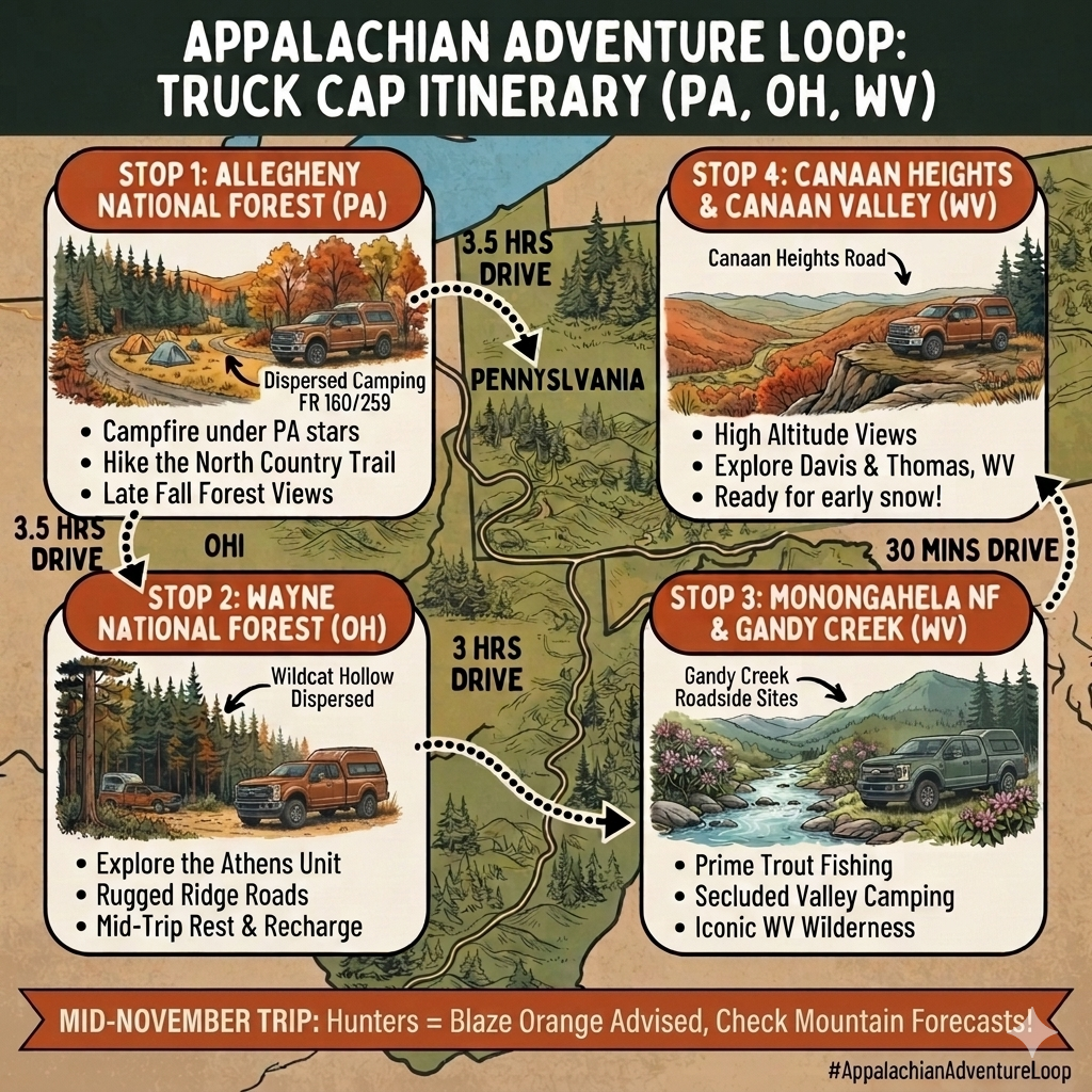
Postponing Michigan also frees up the calendar for a completely different kind of adventure later in the year. Once the summer heat fades and the noise of the 2026 midterm election quiet downs, I am looking toward late autumn. The plan is to take the week of Veterans Day in November to run a true cold-weather circuit through the big woods. I’ll point the SuperDuty toward the Allegheny National Forest, cut south into Ohio to explore the Wayne National Forest—a piece of public land that will be totally new to me—and complete the loop with a few crisp nights high up in the Monongahela National Forest around Canaan Heights before heading back across the New York line. It’s entirely weather-dependent, of course. Early November in those ridges can easily turn overnight, bringing sudden lake-effect bands and blinding ridge-top snowstorms. But that element of unpredictability is exactly what makes an autumn trip feel alive.

The SuperDuty isn’t going to wear out in a single season. The truck sits ready in the driveway, built to last me until my target retirement in 2040 and well beyond. For now, the focus is simple: iron out the bugs close to home, enjoy the quiet of a slow summer, and keep the rig prepped for the long haul.

Map: Essex Chain Lakes
Map: Chain Lake Road

The Adventure Appalachian Loop

With my summer trip to Michigan canceled – I ran out of time to get my gear ready and tested, work constraints, and the difficultly in selecting a route from Chautauqua County to the Nordhouse Dunes in Michigan – I’ve been thinking more about a November trip. Maybe not to Michigan but to Ohio. I would like to see Ohio, another Appalachian State, and maybe some of West Virigina.

5 hrs ➔ Allegheny NF (PA)
3.5 hrs ➔ Wayne NF (OH)
3 hrs ➔ Monongahela NF (WV)

It seems like it would work good with time. The final leg back to Albany is a bit sketchy with time and daylight, though I could either do County Bridge Campground PA if I reserved online, or do an overnight at Sugar Hill or Long Pond State Forest, if I take I-81 back, though that’s a very long day.

1. Allegheny National Forest (Pennsylvania)

Because you are in a truck camper, you can take advantage of Allegheny’s massive, legal roadside network.

  • The Spot: Forest Road 160 (Loleta Road) or Forest Road 259 (Morrison Run). Both feature excellent, hardened, free dirt/gravel pulloffs built explicitly for dispersed vehicle camping.
  • November Advantage: Allegheny’s heavy canopy opens up in late autumn, offering great views, but night temperatures frequently plummet below freezing.

2. Wayne National ForestAthens Unit (Ohio)

From PA, you will take I-79 South to I-70 West / US-33 East to drop straight into Athens County.

  • The Spot: Utah Ridge Road (FR 259) or Wildcat Hollow Trailhead as explored above.
  • The Route Pivot: Camp here for a night or two to break up the drive before crossing the Ohio River into the high mountains of West Virginia.

3. Monongahela National Forest (West Virginia)

Heading southeast from Ohio via US-50 East or US-33 East brings you straight into the “Mon.”

  • The Spot: Gandy Creek Dispersed Area (County Route 29 / Forest Road 17). This is legendary for truck campers. It features miles of wide, flat, completely free roadside pull-outs right along a pristine trout stream.
  • November Advantage: Deep valley walls block high mountain winter winds.

4. Canaan Heights & Canaan Valley (West Virginia)

Just a short, scenic drive up the mountain from Gandy Creek via Route 32 North brings you to the high plateau of Davis and Thomas, WV.

  • The Spot: Canaan Heights Road (Forest Road 13). Located just outside the town of Davis, this rugged mountain ridge road enters a pocket of Monongahela NF land. There are a handful of tight, rocky primitive truck pulloffs near the premium overlook trailheads.
  • Critical Backup: If Canaan Heights gets hit with early lake-effect snow (very common in mid-November at 3,000+ feet), slide down into the valley floor and use the electric/heated hookup sites at Canaan Valley Resort State Park or the winter camping pads at Blackwater Falls State Park.
Terrain Map: Glacial Lake Windham
Thematic Map: Vly Creek Reservior Watershed