Democrats Voting for HR 461
| Democrats Voting for HR 461 Condemning Sheltering Aliens in Schools |
|||
| State | District | Name | Party |
|---|---|---|---|
| AK | AK | Mary Sattler Peltola | D |
| ME | 2 | Jared F. Golden | D |
| NC | 1 | Donald G. Davis | D |
| NC | 13 | Wiley Nickel | D |
| NV | 3 | Susie Lee | D |
| NY | 18 | Patrick Ryan | D |
| WA | 3 | Marie Gluesenkamp Perez | D |
| Andy Arthur, 6/14/23 | |||


Latest Sunsets in America on June 21st
| Latest Sunsets in America (CONUS) | ||
| The places you want to be tonight if you want to be out and enjoying life. | ||
| County | Sunset | Dusk |
|---|---|---|
| Divide County, ND | 10:06 PM | 10:48 PM |
| Williams County, ND | 10:03 PM | 10:45 PM |
| Burke County, ND | 10:02 PM | 10:44 PM |
| McKenzie County, ND | 10:00 PM | 10:41 PM |
| Ontonagon County, MI | 9:59 PM | 10:39 PM |
| Mountrail County, ND | 9:58 PM | 10:40 PM |
| Renville County, ND | 9:58 PM | 10:40 PM |
| Houghton County, MI | 9:58 PM | 10:37 PM |
| Baraga County, MI | 9:55 PM | 10:35 PM |
| Bottineau County, ND | 9:55 PM | 10:37 PM |
| Ward County, ND | 9:55 PM | 10:36 PM |
| Mercer County, ND | 9:52 PM | 10:32 PM |
| Lincoln County, MT | 9:52 PM | 10:34 PM |
| Marquette County, MI | 9:51 PM | 10:31 PM |
| McHenry County, ND | 9:51 PM | 10:33 PM |
| McLean County, ND | 9:51 PM | 10:32 PM |
| Rolette County, ND | 9:51 PM | 10:33 PM |
| Oliver County, ND | 9:49 PM | 10:29 PM |
| Pierce County, ND | 9:49 PM | 10:31 PM |
| Towner County, ND | 9:48 PM | 10:31 PM |
| Andy Arthur, 6/21/23. Data Source: rSuncalc |
||

 compare to Moose River Plains Camping Area?")
The Latest Sunset in Albany is on June 27th
| Sunset Times in Albany | ||
| The latest sunset is a six days after the first day of summer on June 27th. | ||
| Date | Sunset | Dusk |
|---|---|---|
| Wed, 6/21 | 8:37:50 PM | 9:12:52 PM |
| Thu, 6/22 | 8:38:02 PM | 9:13:04 PM |
| Fri, 6/23 | 8:38:11 PM | 9:13:13 PM |
| Sat, 6/24 | 8:38:19 PM | 9:13:21 PM |
| Sun, 6/25 | 8:38:25 PM | 9:13:25 PM |
| Mon, 6/26 | 8:38:28 PM | 9:13:28 PM |
| Tue, 6/27 | 8:38:30 PM | 9:13:27 PM |
| Wed, 6/28 | 8:38:29 PM | 9:13:25 PM |
| Thu, 6/29 | 8:38:26 PM | 9:13:20 PM |
| Fri, 6/30 | 8:38:21 PM | 9:13:13 PM |
| Andy Arthur, 6/21/23.
Data Source: rSuncalc
|
||


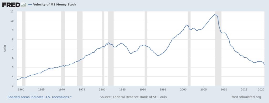
Pandemic our future
strong>Since the start of pandemic the federal reserve has printed over $1,720 billion in cash to buy assets in the economy, to force interest rates below a 0.25%. This hasn't caused inflation yet -- as the velocity of money is lower and falling -- people are saving or investing money all this extra money, not spending it right now. That said, the velocity of money is something to watch carefully, as if it upticks, we could see inflation start to kick in. The federal reserve could have to slam the brakes on the economy in 2021 to break inflation, which would be an unpopular thing to do, if unemployment remains high.
The way the fed would do this is to start selling assets they own, reducing the amount of cash available in the economy. This would push up the interest rates, which make it more expensive buy houses and cars on credit. It also would increase the cost of government borrowing. This would slow down the economy, and if pushed hard crush inflation -- along with crushing the economy, it would crush farmers, local governments, car dealers, and housing builders -- and anybody who relies on credit. Obviously, this would be incredibly unpopular to have Jerome Powell, the Trump appointed fed chair, slamming the brakes on economy when President Biden is in his first term, and there would be all kinds of conspiracy theories, even ultimately it's sound economic theory to bleed inflation out of the system.