Pleasant Valley in Schenectady – April 1952
While not yet built it's obvious that Pleasant Valley was being actively mined in preparation for construction of the future arterial highway.

While not yet built it's obvious that Pleasant Valley was being actively mined in preparation for construction of the future arterial highway.

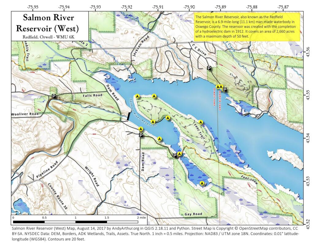
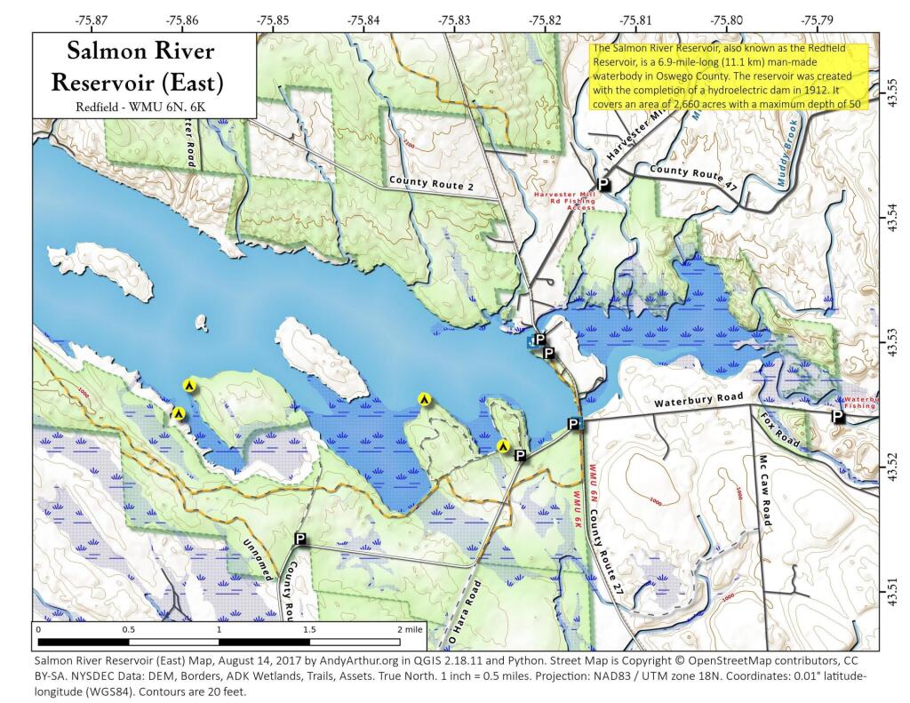
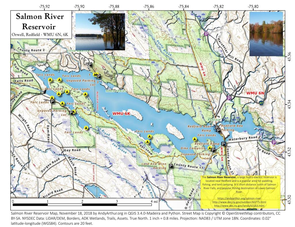
Here is a map and coordinates list for the Salmon River Reservoir Campsites. Scroll down for printable Adobe PDF maps.
| Campsite | Latitude | Longitude |
|---|---|---|
|
Campsite 1
|
43.5309742920692
| -75.8286869256684 |
|
Campsite 2
|
43.5309992915826
|
-75.8297119265923
|
|
Campsite 3
|
43.5322302917437
|
-75.8326449252156
|
|
Campsite 4
|
43.551032398543
|
-75.8886238418359
|
|
Campsite 5
|
43.55177656419
|
-75.8896116338177
|
|
Campsite 6
|
43.5517061750734
|
-75.8905568903452
|
|
Campsite 7
|
43.541756677656
|
-75.9150815169557
|
|
Campsite 8
|
43.5394887698881
|
-75.9090654604258
|
|
Campsite 9
|
43.5360696244194
|
-75.902624135171
|
|
Campsite 10
|
43.5293055917744
|
-75.8953235118337
|
|
Campsite 11
|
43.5373862456009
|
-75.9012726107273
|
|
Campsite 12
|
43.5443809396893
|
-75.9064767993171
|
|
Campsite 13
|
43.5434303332432
|
-75.911225839972
|
|
Campsite 14
|
43.5493296300542
|
-75.9162896181872
|
|
Campsite 15
|
43.5493296300542
|
-75.9162896181872
|
|
Campsite 16
|
43.5494103882571
|
-75.9109502761858
|
|
Campsite 17
|
43.5451002917625
|
-75.8998779023845
|
|
Campsite 18
|
43.5434744124482
|
-75.8959544885348
|
|
Campsite 19
|
43.5237542467868
|
-75.859969258665
|
|
Campsite 20
|
43.5260120162344
|
-75.8588356278734
|
|
Campsite 21
|
43.5263250117288
|
-75.849574714577
|
|
Campsite 22
|
43.5250993776627
|
-75.8329156554249
|
|
Campsite 23
|
43.5213924995858
|
-75.8241771774025
|
|
Campsite 24
|
43.5246466269299
|
-75.8256976582404
|
|
Easement Site 1
|
43.5268720918897
|
-75.8437903809071
|
|
Easement Site 2
|
43.5301618787494
|
-75.8491361432998
|
|
Easement Site 3
|
43.535081215355
|
-75.8643611448784
|
|
Easement Site 4
|
43.5335274180135
|
-75.865935146283
|
|
Easement Site 5
|
43.5367460658778
|
-75.8714414686836
|
Printable PDF Maps of Salmon River Reservoir