Bramley Mountain 🗺️
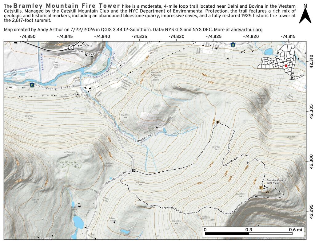
About Bramley Mountain ....
On my bucket list to check out the fire tower on it. Near Bloomville and Delhi.

Helpful Hint: While I suggest you look on blog for a downloadable PDF Map, you should be able to print or save this map by clicking the print button on the map above.
Data Sources
Road Trip to Coal Country by Nate Matthews - You can download the KMZ File used in creation of this map.
OpenTopoMap - Open Topopgraphic Map based on Open Street Map. Contours are metric on this map. Map data: © OpenStreetMap, SRTM | Map style: © OpenTopoMap (CC-BY-SA). XYZ Tiles: https://{s}.tile.opentopomap.org/{z}/{x}/{y}.png
NY Aerial (2020) - High-resolution aerial photography from NYSGIS, photos taken with leaves off in spring time between the years 2016-2020. NYSGIS. WMS Service: https://orthos.its.ny.gov/ArcGIS/services/wms/Latest/MapServer/WMSServer, Layer: 0,1,2,3
3DEP Elevation Hillshade. LIDAR and legacy USGS DRG Topo Derived hillshades used as a background. DEM - WMS Service: https://elevation.nationalmap.gov/arcgis/services/3DEPElevation/ImageServer/WMSServer, Layer: 3DEPElevation:Hillshade Gray
Full List of WMS and ArcMap Services - CSV Spreadsheet with all web map services currently used on the blog.
More about Bramley Mountain...
The Bramley Mountain Fire Tower in Delaware County, NY, is a historic landmark recently restored and reopened to the public after being decommissioned in the 1970s. Originally built in 1925 (or 1950, sources vary), the 60-80 foot steel tower was a vital lookout for forest fires, offering panoramic views of the Catskills. After being dismantled and stored by a local family for decades, a volunteer group, the Friends of Bramley Mountain Fire Tower, led a successful effort to reconstruct it in 2024, making it accessible again via the Bramley Mountain Trail.