Residential Rental Properties in the City of Albany  🗺️

Download a High Resolution JPEG Image of the Residential Rental Properties in the City of Albany or an Adobe Acrobat Printable PDF of the Thematic Residential Rental Properties in the City of Albany.

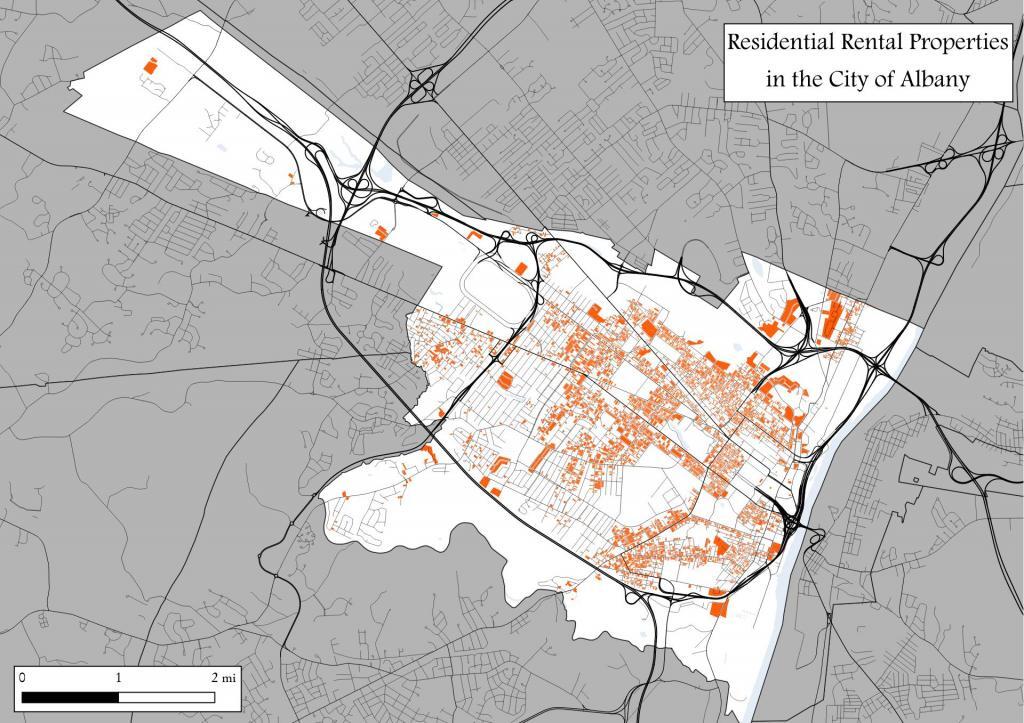
About Residential Rental Properties in the City of Albany ....

Lately there has been a proposal to enact a form of rent stability enhancement known as Good Cause Eviction in the City of Albany. This would ensure renters across the city would be able to maintain their homes, while limiting future rent increases for existing tenants and increasing neighborhood stability. Some neighborhoods in Albany would be greatly benefited by such regulations, although it would come at the cost of higher upfront rents for new tenants and lower profits for landlords with large numbers of long-term tenants.

Data Source: Albany County Property Tax ArcMap REST/SERVICE, showing "PROP_CLASS" IN ('215','220','230','281','411')

Map: Cole Hill State Forest

More about Albany County...

Albany County (/ˈɔːlbəniː/ awl-bə-nee) is a county located in the U.S. state of New York, and is part of the Albany-Schenectady-Troy Metropolitan Statistical Area. The name is from the title of the Duke of York and Albany, who became James II of England (James VII of Scotland). As of the 2010 census, the population was 304,204.[1] As originally established, Albany County had an indefinite amount of land, but has only 530 square miles (1,400 km2) as of March 3, 1888. The county seat is Albany, the state capital.

http://en.wikipedia.org/wiki/Albany_County,_New_York

Map: Cooksburg
SVGZ Graphic: 2022 Governor's Race in Albany County
SVGZ Graphic: 2024 Albany County Presidential Voters
SVGZ Graphic: Age and Gender of Albany County Residents
SVGZ Graphic: Albany County Fire Departments
SVGZ Graphic: Albany County Land Cover
SVGZ Graphic: Albany County Non-Contigous Cartogram
SVGZ Graphic: Albany County Presidential Vote, through the Years
SVGZ Graphic: Colonie Town Supervisor Race - 2021
SVGZ Graphic: Counties with a Similiar Population Density to Albany County
SVGZ Graphic: Most Similiar Land Cover to Albany County
SVGZ Graphic: Population Gain and Loss in Albany, 2000 to 2020
SVGZ Graphic: Population of Albany County
SVGZ Graphic: Weighted Population of Albany County Towns
Terrain Map: Albany County New Buildings 2015-2019
Terrain Map: Capital Region Land Use
Terrain Map: Development In The Albany Area
Terrain Map: Heldebergs
Terrain Map: Hills and Hollows Eastern Heldebergs
Terrain Map: Hills and Hollows Western Heldebergs
Terrain Map: Lake Albany
Thematic Map: 2020 Presidential Election in Albany County
Thematic Map: 2024 National Land Cover Dataset - Albany County, New York
Thematic Map: Albany County - Soil Dranage Class
Thematic Map: Albany County NY Towns
Thematic Map: Albany County Population Density - 3D Rendering
Thematic Map: Albany County Watersheds NAIP Imagery
Thematic Map: Albany County, NY Sub-watersheds
Thematic Map: Albany-area Urbanization between 2001 and 2019
Thematic Map: Areas of Prime Farm Land in Albany County
Thematic Map: Elevation of Albany County
Thematic Map: Level 4 Ecoregions in Albany County.
Thematic Map: Log Homes of Albany County
Thematic Map: Median Year Building Built, Albany County
Thematic Map: Named Summits in Albany County, NY
Thematic Map: Nobody Lives Here - Zero Populaton Blocks in Albany County
Thematic Map: Normans Kill Watershed
Thematic Map: Populated Places in Albany County, New York
Thematic Map: Wetlands of Albany County
Photo: Green
Photo: White
Photo: Summer
Photo: Vly Creek Reservior
Photo: Swamp
Photo: Frothingham Lake
Photo: Daisy

Leave a Reply

Your email address will not be published. Required fields are marked *