Interactive Map
Here is an interactive map of the campsites and trails along the East Branch of Sacandaga River.
Printable Map
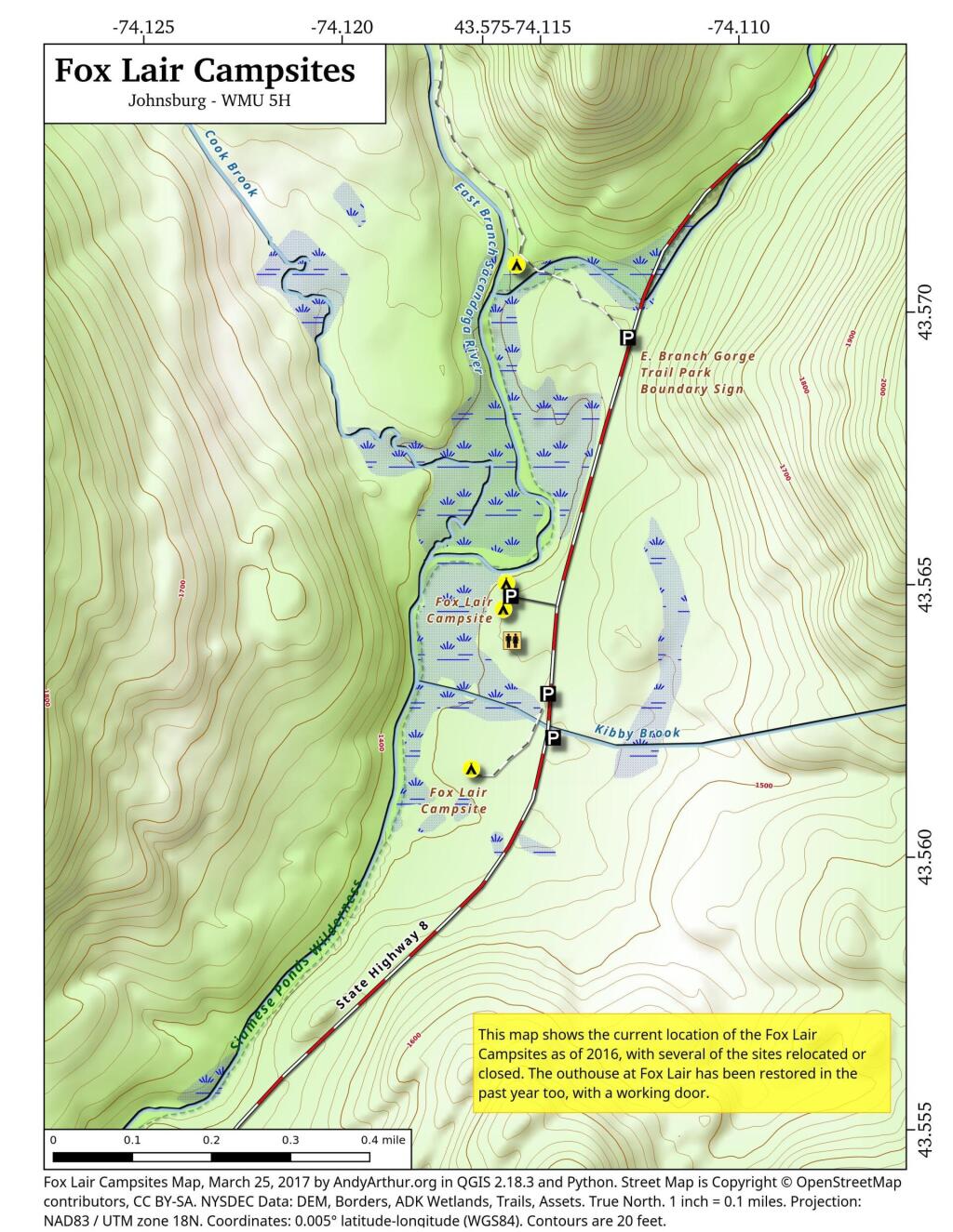
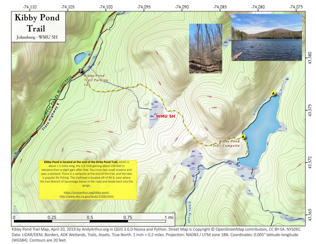
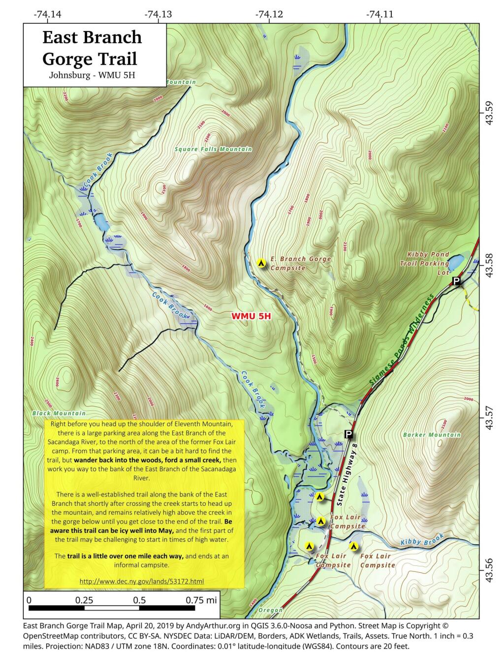
Here are several helpful printable maps.
List and Coordinates for Campsites and Trailheads
Here is a list of campsites, trailheads and other destinations along NY 8 and East Branch Sacandaga River. You can also get this as a Google Sheets.
| Name | Details | Latitude | Longitude |
| 11th Mountain Parking Lot | Large > 20 Cars | 43.5903782 | -74.0900314 |
| 11th Mountain Trailhead Campsite | Near large parking area for 11th Mountain | 43.5901834 | -74.0910822 |
| Boulder Rock Campsite | Cave-Like Site Against Large Erratic | 43.5384607 | -74.1215703 |
| Cod Pond Parking Lot | Medium 5 – 20 Cars, across from campsite 7 and 8 | 43.5301580 | -74.1455890 |
| Cod Pond Trail Campsite | At end of Cod Pond trail on pond | 43.5176969 | -74.1437559 |
| County Line Brook Trail Campsite | Along County Line Trail | 43.5242772 | -74.1892664 |
| County Line Campsite | End of County Line Trail | 43.5022688 | -74.1828085 |
| E. Branch Gorge Campsite | End of East Branch George, near Waterfalls | 43.5803187 | -74.1209517 |
| E. Branch Gorge Trail Parking Area | Small < 5 Cars | 43.5690250 | -74.1132232 |
| Eagle Pond Campsite | Near Eagle Pond | 43.5401509 | -74.1167243 |
| East Sacandaga River Parking Picnic Area | DOT Maintained Roadside Parking And Picnic Area | 43.4783862 | -74.2010766 |
| Forks Mountain Trail – Bushwhack to Auger Falls | 43.4685687 | -74.2457562 | |
| Georgia Creek Parking Lot | Medium 5 – 20 Cars | 43.4915171 | -74.1892866 |
| Girrad Sugarbush Trailhead | 43.4764458 | -74.2043731 | |
| Griffin Connector Parking Lot At Route 8 | Medium 5 – 20 Cars | 43.4703209 | -74.2248680 |
| Kibby Pond Campsite #3 | Far End of Lake | 43.5766649 | -74.0781098 |
| Kibby Pond Trail #2 | End of Trail | 43.5725581 | -74.0821443 |
| Kibby Pond Trail Parking Lot | Small <5 Cars | 43.5789951 | -74.1033601 |
| Little Joe Pond Campsite | At Little Joe Pond | 43.5055662 | -74.1423052 |
| Little Joe Pond Picnic Site | 43.5039558 | -74.1422817 | |
| Mud Ponds Campsite | At Mud Point | 43.5650797 | -74.1739273 |
| NY 8 Campsite 1 | Old Routing of 8, Near Kibby Pond Area | 43.5771279 | -74.1054574 |
| NY 8 Campsite 2 | Overlooks Cliff | 43.5650960 | -74.1160232 |
| NY 8 Campsite 3 | Long dirt road to open area | 43.5616391 | -74.1169664 |
| NY 8 Campsite 4 | Dirt road to campsite above Kibby Brook | 43.5612062 | -74.1138524 |
| NY 8 Campsite 5 | Old home site, sits on ledge above NY 8 | 43.5542527 | -74.1234025 |
| NY 8 Campsite 7 | 1/4 mile north of Cod Pond Parking | 43.5328656 | -74.1440210 |
| NY 8 Campsite 8 | Near Cod Pond Parking | 43.5316564 | -74.1459341 |
| NY 8 Campsite 9 (Seasonal Use) | Route 8 Near Little Joe Trail Pulloff With Fire Ring (Campsite Removed During Winter) | 43.5149220 | -74.1583197 |
| NY 8 Campsite 10 | Gravel Pit 1/4 mile south of Girrad Sugarbush Trailhead | 43.4761691 | -74.2072253 |
| Oregon Trail Primitive Campsite | Beyond Stewart Creek Snomwobile Bridge | 43.5194607 | -74.1339532 |
| Parking Lot | Medium 5 – 20 Cars | 43.5355769 | -74.1414217 |
| Shanty Brook Trail Campsite | Along Shanty Brook Trail | 43.5460737 | -74.1459537 |
| Shanty Falls Parking Lot | Small <5 | 43.5376556 | -74.1409559 |
| Square Falls | 43.5814233 | -74.1218099 | |
| Stewart Creek Bridge | 43.5204188 | -74.1356239 | |
| Stewart Creek Flume | 43.5204188 | -74.1356239 | |
| Stewart Creek Lower Falls | 43.5225332 | -74.1365675 | |
| Teachout Road Bridge Over Griffin Falls | 43.4733545 | -74.2236654 | |
| Teachout Road Parking at Griffin Falls | 43.4737995 | -74.2238438 |