![Untitled [Expires March 27 2025]](https://andyarthur.org//data/photo_017210_large.jpg)
Long Lake 📍
🗺️ Maps

Whitney Park Property
This interactive map shows the boundaries of the Whitney Park Property outside of Tupper Lake, between the Whitney C. William Wilderness and Forked Lake Campground.

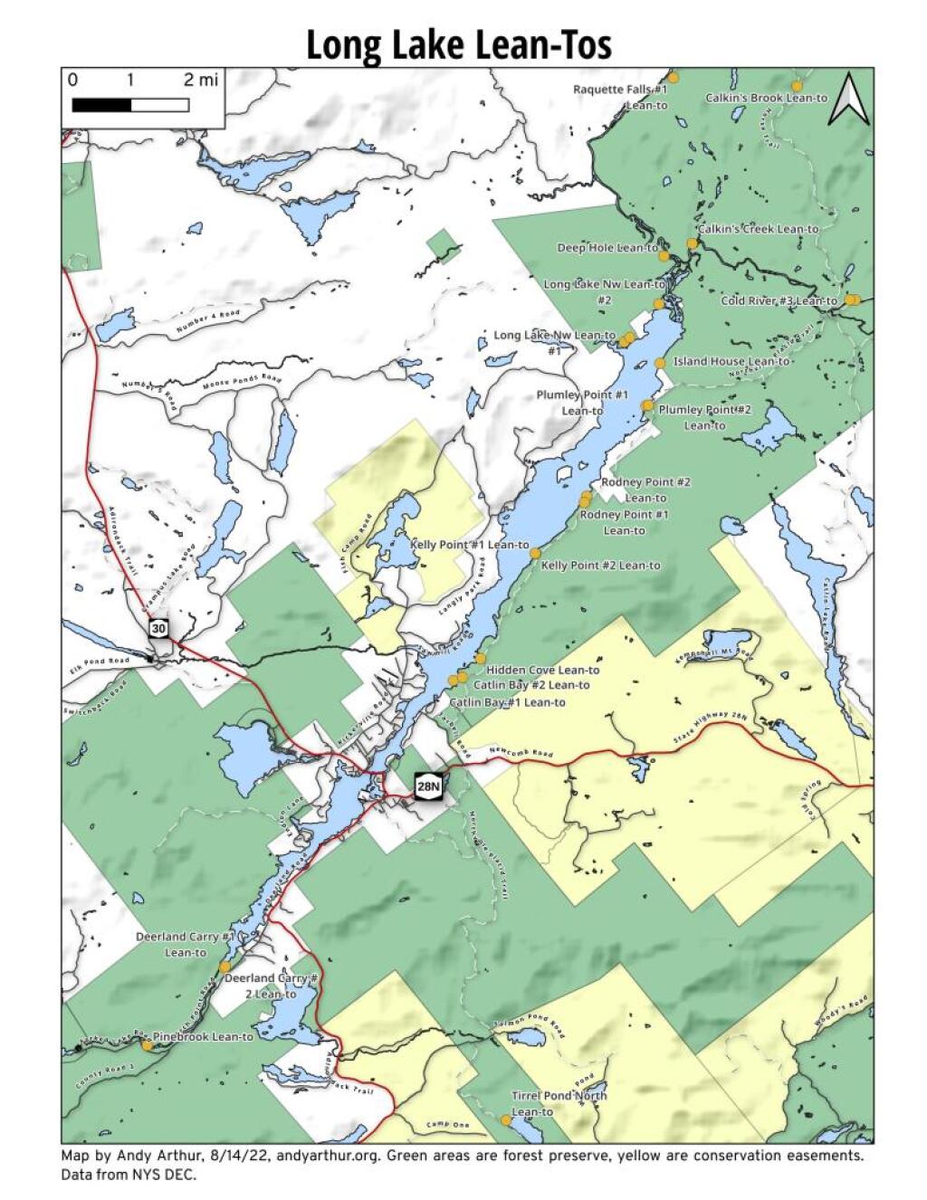
Long Lake Lean-Tos – Coordinates and Maps
Long Lake Lean-Tos – Coordinates and Maps 🏕
| Name | Unit | Latitude | Longitude |
| Calkin’s Creek Lean-To | High Peaks Wilderness | 44.1058294131448 | -74.3120366857115 |
| Catlin Bay #1 Lean-To | High Peaks Wilderness | 43.9980126926989 | -74.3927845610842 |
| Catlin Bay #2 Lean-To | High Peaks Wilderness | 43.9972143811434 | -74.3959393656481 |
| Cold River #3 Lean-To | High Peaks Wilderness | 44.0914592780512 | -74.257641750845 |
| Cold River #4 Lean-To | High Peaks Wilderness | 44.0913902533326 | -74.2557348025251 |
| Deep Hole Lean-To | Sargent Ponds Wild Forest | 44.1027442039184 | -74.3218627059816 |
| Deerland Carry # 2 Lean-To | Sargent Ponds Wild Forest | 43.9262175397083 | -74.4753958671918 |
| Deerland Carry #1 Lean-To | Sargent Ponds Wild Forest | 43.925780718913 | -74.4758457554482 |
| Hidden Cove Lean-To | High Peaks Wilderness | 44.0026552881939 | -74.3864802632516 |
| Island House Lean-To | High Peaks Wilderness | 44.0760291646623 | -74.3235341650571 |
| Kelly Point #1 Lean-To | High Peaks Wilderness | 44.0288002361709 | -74.3673079859906 |
| Kelly Point #2 Lean-To | High Peaks Wilderness | 44.028702567172 | -74.3671303486795 |
| Long Lake Nw Lean-To #1 | Sargent Ponds Wild Forest | 44.0814068182887 | -74.3358291460985 |
| Long Lake Nw Lean-To #2 | Sargent Ponds Wild Forest | 44.0825043385337 | -74.3339145724739 |
| Moose Pond Stream Lean-To | High Peaks Wilderness | 44.079589788976 | -74.2389368366902 |
| Moose Pond Stream Lean-To #2 | High Peaks Wilderness | 44.079553878647 | -74.2391509433142 |
| NA | Sargent Ponds Wild Forest | 44.0907781103628 | -74.323731553366 |
| Plumley Point #1 Lean-To | High Peaks Wilderness | 44.0654422643994 | -74.3285192442171 |
| Plumley Point #2 Lean-To | High Peaks Wilderness | 44.0655989161076 | -74.32761224546 |
| Rodney Point #1 Lean-To | High Peaks Wilderness | 44.0414093848994 | -74.3501490963956 |
| Rodney Point #2 Lean-To | High Peaks Wilderness | 44.0429767454126 | -74.3493346475314 |


Traffic Counts in Long Lake
I was quite surprised how relative little traffic goes through the village of Long Lake. While sometimes busy in the summer months, the AADT of traffic going north through the village to Tupper Lake is a paltry 579 cars per day (or an average of one car passing every 2 1/2 minutes), although heading east on NY 28N towards Newcomb and Thruway, it's 1684 AADT or roughly one car per minute. Probably daytime traffic is much higher then nighttime traffic, although it looks the DOT hasn't done a time of day study.
