Black Bear Mountain
Download a High Resolution JPEG Image of the Black Bear Mountain or an Adobe Acrobat Printable PDF of the Black Bear Mountain.
About Map: Black Bear Mountain ....
43.76917976445229,-74.7697504393449
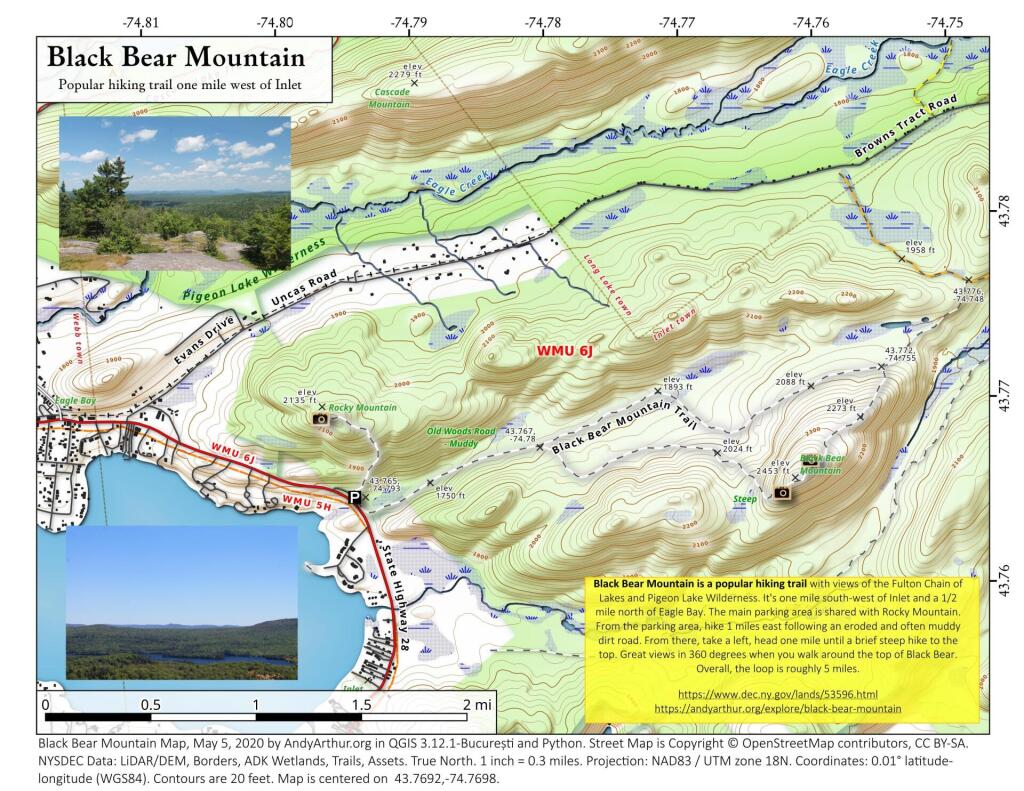
Black Bear Mountain is a popular hiking trail with views of the Fulton Chain of Lakes and Pigeon Lake Wilderness. It's one mile south-west of Inlet and a 1/2 mile north of Eagle Bay. The main parking area is shared with Rocky Mountain. From the parking area, hike 1 miles east following an eroded and often muddy dirt road. From there, take a left, head one mile until a brief steep hike to the top. Great views in 360 degrees when you walk around the top of Black Bear. Overall, the loop is roughly 5 miles.
https://www.dec.ny.gov/lands/53596.html
https://andyarthur.org/explore/black-bear-mountain


Bookmark my free Interactive GPS Map for your phone:
https://andyarthur.org/ny
... shows your location as a blue dot in relationship to campsites, trails, state land. This online map requires cell service, won't work in remote country, so also bring a paper map.
Free Download of New & Historical USGS 1:24k Topograpic Maps
Interactive maps with backcountry and roadside camping: New York, Pennsylvania, West Virginia & Vermont. List of NYS DEC Lean-Tos and Firetowers.
Google Spreadsheet with Roadside, Primitive and Pay Campsites
More about Black Bear Mountain...
The trailhead for Black Bear Mountain is just off NY 28 between Inlet and Eagle Bay, north of Old Forge. It is also the trailhead for Rocky Mountain, a short steep climb to good views of the Inlet area of Fourth Lake. The trailhead parking appears to be on a short section of an old abandoned highway.
The trail up Black Bear starts at the end of the old road / parking lot nearest Inlet. There are two routes up Black Bear, the shorter, but steeper route of 1.9 miles and the longer but muddier route of 3.1 miles. There is another trailhead on Uncas Road that isn't as steep but is 2.2 miles to the summit.


