experience

9-11 – A Memoir

For the three-year anniversary of September 11th, I felt it would be appropriate to put to a short memoir of that day. After all this time, it still rings amazing clear from the time I first found out until I became aware at the truly horrifying nature of the attack. Still, I realize that memory fails over time, so I figured that I ought to put it all down on paper the best way possible.

The day was September 11, 2001 and it was a Tuesday. I got to sleep into about 8 AM, as my first class was not until 11 AM. My dad was still home, helping my grandfather who had been sick the previous night. I woke up, read the papers online and offline, and took a shower like usual. Looking out, it was going to be a beautiful, clear and crisp September day. It was ideal weather. I was happy, as I was starting to love college and all the freedom it brought, even though I had only been there for two weeks total.

Right after I had taken my shower, and was about to leave with my dad to take him to work and for me to go to college, my mom called. She just called to check in, and to find out if dad was planning on going to work with me. Over the phone she mentioned that a plane had hit one of the World Trade Center buildings, though it didn’t get much of reaction from me. At that point, I knew that the World Trade Center buildings were those big and tall, ugly gray buildings in the skyline of the city, but little more.

Plane accidents and other rather horrific things are announced on the news all the time, so I wasn’t particularly surprised. It was 9:30 about then, and I hopped in my car and turned on the radio and listened to music for about 10 minutes. A little before 9:45 AM, there was a news bulletin about this story, and it suggested that I turn to WGY radio station for more details. The news bulletin suggested it might be terrorism. Flipping to WGY, I was shocked to hear that the FAA thought that several planes had been hijacked that this was part of a massive attack on the United States.

I listened carefully. Details on the radio were often sketchy and confusing. There was the Pentagon attack, two or one planes in the World Trade Center, and a lot of other information that proved to be wrong. My dad and me speculated on what this would mean to the United States, and how different policy actors would react to these attacks. He said it would be an incredibly interesting time to be studying Political Science.

I dropped him off to work at the Center for the Disabled in South Albany. He got out of the car, and suggested I turn off the radio so not to be distracted while driving. I went to turn on the music station I was listening to previously, but it just mirrored WGY. Clear Channel directed all its stations to these terrorist attacks. I got to college at about 10:30 A.M., and by then I started to get a fairly good idea on what had happened, though many of the details were still sketchy.

The attack had left me feeling a bit overwhelmed and shocked at the same time. It was a rather strange feeling, one that is nearly impossible to describe in words. I was downright angry that any individual or group could be so wasteful and do such destruction. I also felt like I was deathly alone, even though I was sitting in a parking lot full of students all sitting in their cars listening to the radios. Still, I stayed at college, intent on going to my class. I wasn’t particularly scared, though I guess it would have been smart to evacuate the city to go home, where I would have been safe. I just could not seem to personalize these events until I saw them.

I got out of my car about 10:45 AM and walked over to Amstuz Hall for my 11 AM Statistics Class. When I got there, the television was on, showing for the first time some of the most horrific scene I had ever seen. The bright blue sky contrasted against the burning buildings. They repeatedly showed the same couple of seconds of poorly shot film of the second plane hitting the building and the smoldering one plain. Then the news got worst: one of the buildings had collapsed. The news was so horrific, though nobody really knew how to react.

Throughout the day, a question kept popping up in my mind: what would this mean to us Americans? I knew how a post-Columbine world meant the decline of our civil liberties in High School, and I couldn’t imagine what would become of America. Some of the radio commentaries hinted slightly at this issue, though most it was drown out by the shock and hype about this day. I went as far as to mention to a friend that I thought “the worst tragedy won’t happen today, but September 12 or whenever Congress gets back down to business”. I knew that future legislation like the PATRIOT Act would greatly threaten our liberties.

A little after 11 AM, I was notified that all classes were canceled for the day. I called my mom and let her know I was okay, classes were cancelled, and that it looked like both towers had fell. Then, I hopped in my car and went home. But first, I sat in my car, waiting for traffic to clear, as thousands of students fought to get out of the parking lot. I sat in my car listening to the continuing radio coverage. I got home, and laid back, and drowned out the whole world.

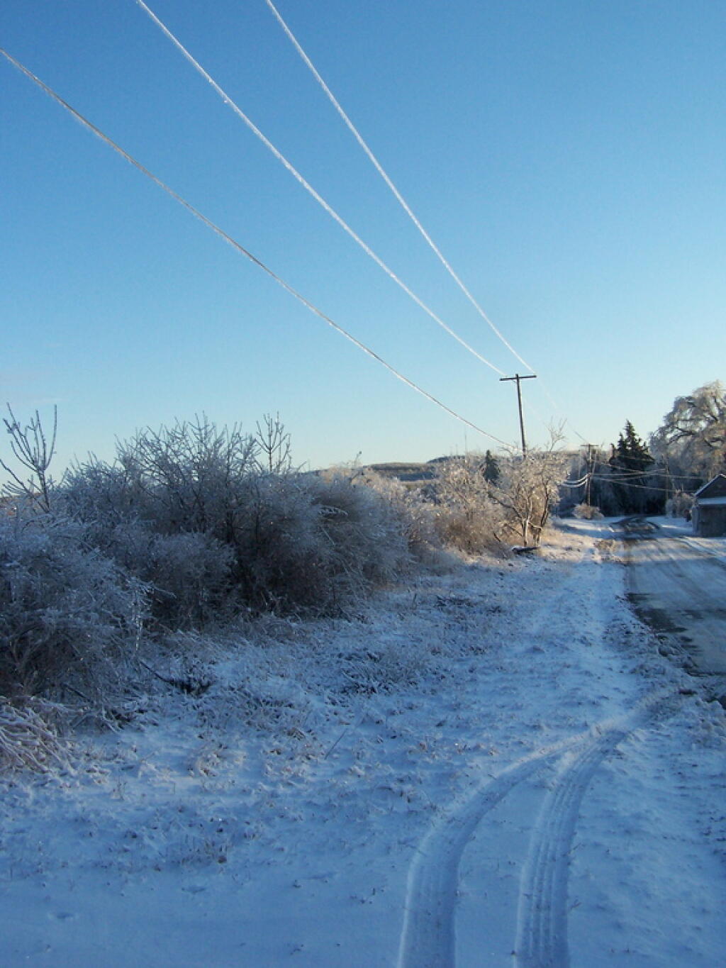
Looking up at the sky the next couple of days, it was kind of refreshing to see a clear sky without any planes. It was kind of strange, but nice without the roar of jet engines passing distantly above, or jet trails clogging up the clear sky. I kind of wished the world would further remain this way, but I knew such an ideal was impossible to reach.

September 11th came and went. It was a shock, as was the drum beat up to war. This was the first real war of my lifetime, and it challenged me to think about my pacifism in new ways. I fought passionately for civil liberties in class debates, but my wonderful History of the 20th Century Professor Carmen was probably right to a degree: things had to change a bit for war, and that we had to give up only a few civil liberties. Still, I just wish this attack never happened, and that we could enjoy the full liberties of yesteryear.

Remembering the Ice Storm ’08

Notes on the Re-Run for Tuesday, December 6th.

— Andy

Throughout Friday, freezing rain, sleet, and snow came down, covering the State Capitol and surrounding building with a layer of ice.

Snow Capitol

The ice weighted down trees and made everything look “wet”, but it did not pile up all fluffy like we think of snow being.

Snow Across Hudson

Here are the Heldeberg Mountains covered with ice and beauty.

Heldebergs in Ice

The next morning walking through the woods, covered with ice and beauty at Cole Hill State Forest.

Ice Beauty

The swamp at Cole Hill was just shimmering in light.

Ice Swamp

While driving the pickup for a while got the ice melted off the doors, it kept freezing shut, and I had to keep cracking the ice off the doors.

Pickup with Ice

Ice on a Pine Tree at Thatcher Park.

 Ice Pine

Branches covered with ice where so pretty.

Ice Limbs

Even when it was on the power lines and knocked out power to thousands.

Ice on Power Lines

The Ice Storm of 2008 was so beautiful, even if it did knock out power and close down roads.

Paying My Respects to the Lake Champlain Bridge

Notes on the Re-Run for Thursday, December 22nd.

It was almost two years ago when they blew up the old Lake Champlain Bridge…

— Andy

Yesterday, I drove up to Chimney Point, in Vermont outside of Addison to witness the sad but historic passing of the Champlain Bridge. The massive 80-year old span was imploded into the frozen lake, after two piers where discovered badly damaged, and was determined to be likely to fail catastrophically without a controlled demolition.

Old Lake Champlain Bridge

It is sad to see such a historic landmark go. Nobody really wanted to see such a landmark go up into a pile of rubble. As I stood there on Chimney Point, I stood next to many farmers and other local residents who had been alongside of and over the Champlain Bridge thousands of times. It’s such a big landmark, that stands out over the landscape, with it’s arches reaching 130 feet above the flat landscape around. Pictures simply don’t do justice. Many had grown up seeing it’s majestic spans and beautiful archways, and just assumed it would always be there. Some of the oldest residents might even remember back 80-years ago to 1929, when the bridge was under construction.

Walking to the Bridge on VT 128

It was truly a community event. I swear every person from the very rural Addison County, VT and surrounding areas had to have been there. I don’t think I’ve ever seen so many pickup trucks with dairy-farming related bumper stickers, men and children with muck boots on, Carharts and seed-hats. It was such an amazing group of people, with such a complicated mix of emotions about the demolition of the bridge. People where sad to see it go, but also hopeful for the new bridge. Some where cynical that something ever as great could be built again.

Clean Car States

The wintry weather made the span almost invisible from the site about 3,000 feet away from the bridge where I was looking at. Chimney Point had probably the best viewpoint of the Champlain Bridge on a sunny day, your back would be to the sun, and with a back drop of the Adirondack Mountains. You could see the bridge fade in and out like a ghost as the snow squalls blew out and blew in. What you could see was so massive, so beautiful. Yet eerie, because all that was left was the lightest silhouette of the old bridge. The silhouette was so light, that it was hidden from the camera.

Silluote of the Bridge

Then there was the loud bang, right at ten in the morning — a thunderous roar lasting less then a second or two, that shook the ground and sent ice soaring a foot into the air on Lake Champlain, even as far away as we where. The energy wave forced upon the lake and the surrounding landscape shook the parked cars so hard that it set off car alarms. It was not like listening to a firecracker going off, but more like a wave of energy coming at you. In the wintry blizzard-like weather, you barely saw the bridge fall, but it was still the most remarkable feeling at you felt the thousands of tons of steel and concrete hit the waters of Lake Champlain.

Vermont 127 and Vermont 17 where one way during the day to allow for parking, so leaving everyone had to drive by the fallen bridge. The once majestic bridge was little more then just a pile of rubble sticking up from the frozen lake in a wintry fury of the snow. I looked like something out of a war photograph, although it was much bigger and much more realistic. It was a bit scary that we as a society could convert such a massive and beautiful structure to just a pile of rubble.

Bridge Remains

On the 400th Anniversary of Samuel de Champlain’s discovery of Lake Champlain and the fertile plains that surround it, it’s sad to see such a man-made landmark go. Yet, it’s also a reminder of how man made landmarks come and go, and only natural wonders like the mountains and the lake remain. While people since 1929 have looked out across the lake at Chimney Point at the engineering marvel of Champlain Bridge, much of the rest of the landscape remains unchanged since the day Samuel de Champlain first made his voyage in 1609.

A new bridge will replace the first Lake Champlain bridge, and service the automobile, truck, pedestrian, and bicycle needs of the 21st century, but it will be little more then an impermanent landmark that must someday fall and be destroyed like the first Lake Champlain Bridge. Nobody can foresee the demolition of the new bridge, in some future century, but it will ultimately be gone just like the first bridge is now gone.

(this picture taken just north of the bridge was taken in March 2006).

Blue – Bridge
Yellow – My View
Green – Where I Parked


View Champlain Bridge Demo in a larger map

April

April Showers; Bring May Flowers. β€”Common Folk Proverb

The month of April is when in Albany we see the last snow showers of the year, and the winter is washed away by the occasional rain showers that dot the days. April in Albany is not a particularly rainy month, and indeed with the rapidly warming temperatures and dry weather leaves us with the highest wildfire danger of year.

By the end of the month, the valleys will start to show the first signs of green, and our world will start to return to it’s “technicolor” beauty. It will largely be a month of browns and grays in the mountains, occasionally with the lack of shade, the weather will be hot and brutal. We will all get bad sunburns in the next month, often the worst sunburns of the year, with no place to hide from the sun that is getting higher over our heads every day.

Sidewalk

Over the next month, the daylight will grow by almost 2 hours, with the sun not setting until after 8 PM by the time May rolls around. The sun will start rising an hour earlier to. This bright springtime sunlight will start waking up nature’s cycles and engaging spring time weather by the end of the month. Green will be popping up everywhere.

Sunset Brush

April is in many ways November in reverse. November takes us from the delightful color of October into the wintry December. April leads us from the cold harsh weather of March back into the delightful color of May. Warm weather is heading our way, as is the beauty of springtime.

 Rainy Skies

Enjoy the month, get out, and enjoy some of the bright clear days that make April such a charming month.

Camping at Cedar River Flow, August 12

Buying Firewood. There is this great place for campfire wood on Cedar River Plains Road, about 8 miles in. You get a lot of wood for $5.

Buying Firewood

Cab Full of Firewood. The seat and floor boards where stacked with firewood. It kept me going for the next 4 days, although I really didn’t have big fires until the last day when I was up at Mountain Pond. That may have violated DEC firewood regulations, at moving the wood 60 miles, but too bad. It’s my wood.

Cab Full of Firewood

Wild Blueberry Fields. I decided I wanted to drive up there from Cedar River Flow, to eat some, because I knew they would be in peak. This is an hour away (or 15 miles away at 15 MPH), up in the sandy plains of Moose River Plains from Cedar River Flow. These are some of the best blueberry fields in the Adirondacks, and despite being in season for three weeks and very popular, still have many berries to pick.

Wild Blueberry Fields

Blueberries. All I can say is delicious. And so numerous, as you look around all you see is blueberries.

Blueberries

Helldiver Pond in Evening . Watching the sun set over Mitchell Ponds Mountain.

Helldiver Pond in Evening

Moose River Plains Road After Dark. It’s an interesting road to drive after dark, being so narrow, twisty, and rough, especially after drinking all day.

Gray start to Saturday morning

Camping at Site 8. This is down by the Wakely Dam. The prior day I spent paddling around Cedar River Flow and up the river a ways.

Camping at Site 8

Picnic Table. I have yet to pick up my gear. It took a while to figure out which trees to use to set up the site, but ultimately with the steel poles, I got it set up.

Picnic Table

Kayak Tying Down Tarp. I couldn’t quite figure out how to keep the tarp tied down. I tried to use a wood stake, but it kept pulling out of the ground. The kayak worked well for this purpose.

Kayak Tying Down Tarp

Packed Up and Ready To Go. See I’m all packed up and ready to go. Kayak is on the roof, and the site is all cleaned up. I don’t leave a mess or do ny kind of damage to site. Anything unburnt in the fire pit, I haul out.

Packed Up and Ready To Go

Heading Across Wakely Dam. It certainly is not a real pretty morning out there. So be it.

Heading Across Wakely Dam

Cedar River Flow Campsite No 8. It’s a pretty descent basic little campsite. Now off to Owls Head Mountain Firetower.

Cedar River Flow Campsite No 8

Kayaking Cedar River Flow, August 2010

The Cedar River Flow is a 3 mile dammed up river, that provides a beautiful area to paddle around in between the Blue Ridge Hills, and other mountains that surround it. There are dozens of campsites along the lake, you can paddle on around in. On August 11th, I camped up at the Cedar River Flow Camping-area in my pickup truck, and paddled around the lake, up into the Cedar River a ways beyond the end of the flow.

Cedar River-Limekiln Lake Road

Hook Near Payne Brook. Where it enters the Cedar River Flow, about a 1/2 mile from the entrance of the Flow.

Hook Near Payne Brook

Across Cedar River Flow. This more open portion was a bit rougher, although the wind was pretty slack on this day. Blue Ridge is in the distance.

Across Cedar River Flow


Wakely Fire Tower. As seen from the middle of Cedar River Flow, over Sturges Hill. I previously hiked it, and it was a nice hike</>.

Wakely Fire Tower

South Over Cedar River Flow. It was pretty bright and glarey on the lake. I had my sunglasses on, and even had enough sunscreen on, along with the cowboy hat, but not putting sunscreen on my legs, left with me with bad burns on the legs.

South Over Cedar River Flow

Parked on Cedar River Flow. At one of the campsites. I really had to take a piss, because that’s what drinking beer does to me, and it’s pretty hard to do in a kayak, without hoping out.

Parked on Cedar River Flow

Campsite on Cedar River Flow. This was one of the less nicer campsites on Cedar River Flow, causally developed and not by the DEC. The nicer paddle in campsites have picnic tables, and outhouses.

Campsite on Cedar River Flow

View from Cedar River Paddle-In Campsite. Quite nice, and a sandy beach for swimming and getting clean.

View from Cedar River Paddle-In Campsite

Edge of Cedar River Flow. This was at the campsite I pulled off at to take a piss.

Edge of Cedar River Flow

Cedar River Flow Becomes Marshier. As you proceed west on Cedar River Flow, it becomes shallower and shallower, until it’s marshland. It can be a little hard to paddle if you get out of the channel, but in the channel, it’s pretty deep.

Cedar River Flow Becomes Marshier

Marshy Flow and Pillsbury Mountain. This is almost the end of the flow, before it becomes all marsh, and you have to follow the Cedar River to get farther west then this.

Marshy Flow and Pillsbury Mountain

Sturges Hills and Wilson Ridge. This is across the marshy end of Cedar River Flow, looking to the north-west.

Sturges Hills and Wilson Ridge

Tougher Paddling. Soon I will find my way onto the Cedar River, which gets much easier, despite a fairly strong current on the river.

Tougher Paddling

Canadian Geese. On the Cedar River Flow.

Canadian Geese

Pond Lillies on the Marsh and Mush. Not fun at all for paddling through on the Flow. That said, if I was in the channel, it wouldn’t be so hard, but I was looking for another stretch and piss spot. All that beer made for tough going in the boat.

Pond Lillies on the Marsh and Mush

End of Cedar River Flow. From here it’s just marshland and the river, flowing to the south west.

End of Cedar River Flow

Paddling Thru Cedar River. The current was pretty strong, but still very much paddle-able from here.

Paddling Thru Cedar River

Down Along the Cedar River. It was a pretty afternoon for paddling, but my arms where starting to feel it against the current of the river.

Salad for the Pine Bush Dinner

Navigating Oxbow in Cedar River.

Navigating Oxbow in Cedar River

Back in the Flow. The low hills of Blue Ridge and Sturges Hills follow along the landscape of the flow.

Back in the Flow

Heading East Along Cedar River Flow. Only a couple miles back to the campsite.

Heading East Along Cedar River Flow

East Across Flow.

East Across Flow

South Across Cedar River Flow.

South Across Cedar River Flow

Kayak in Site on Cedar River Flow. This is one of the beautiful kayak-in sites that the DEC is proposing to close to appease the environmental extermists who believe the public should have no access to public lands.

Kayak in Site on Cedar River Flow

Very Basic Campsite. Still it seemed like some place that would be nice to paddle in one day with a tent.

Very Basic Campsite

A Quick Swim, Then Back in Kayak. This is another nice sandy beach at Cedar River Flow.

A Quick Swim, Then Back in Kayak

Shoreline Near Payne Brook. This is the hook that jets out into Cedar River Flow.

Shoreline Near Payne Brook

Kayaking Pass an Island. On the Cedar River Flow.

Kayaking Pass an Island

Island with Pillsbury Mountain. And several other mountains, looking west down towards the Plains.

Island with Pillsbury Mountain

Past the Payne Brook. On the Cedar River Flow. Almost back to Wakely Dam, and the drive-in campsites.

Past the Payne Brook

Flooded Lake. This portion of the Cedar River Flow, demostrates how very much this area was once open plains, until the DEC flooded the area shortly after obtaining the land from Gould Paper Company in 1967.

Flooded Lake

Back to the Wakely Dam. As you can see, it’s already starting to get dark. By the time I’m out of the water, and cleaned up, it’s already 6:30 PM. I then go for a little drive up to the plains (an hour away), and pick blueberries.

At the door

The Wakely Dam. There are no posted weight restrictions on this dam, and people regularly bring their fifth wheel campers across it. That said, the Albany bureaucrats in the DEC wants to close off vehicular access, because they don’t believe the public should be allowed to camp on their own lands, especially not in something like a pickup truck or an RV.

The Wakely Dam

Getting Ready to Pull Out. I’m camping at the site right next to Wakely Dam</>, namely site No 8.

Getting Ready to Pull Out

Here is a map of the lake. The Wakely Dam is to the North, the Cedar River flows from the south in the West Canada Wilderness.

A Rainy Day at Cedar River Flow, July 23

I had originally planned on exploring Moose River Plains, on Friday July 23 during my vacation. It however rained and rain, and I had to hide out under the tarp the whole time. So I spent most of the day camping out and reading.

Getting Breakfast Ready. Yes, I have lots of cheap trashy plastic crap that I use for camping. And I use styrofoam bowls and plastic silverware as much as possible, because clean up only involves using some matches and a fire.

Getting Breakfast Ready

Cearel in Plastic Box. I stored all of my food in these 10 plastic boxes that I got at Walmart for $10. It helped things from getting all smashed up, and made organization much easier.

Highest Elevation Populated Places in NY State

It just poured and poured. It was a real rainy Friday. I ended up driving down to Indian Lake to buy some more ice and food, and to check the internet.

A Rainy Friday

I spent a lot of time listening to radio in the rain and reading books.

Listening to Radio in the Rain

After a while, all the rain started to make the tarp sinks due to the wet. Eventually, even the Christmas lights shorted out.

Tarp Sinks Due to Rain

But by evening, things started to clear out at the Cedar River Flow. It was refreshing after Friday’s long day of rain.

Cedar River Flow Clearing

That was Day 3 at Cedar River Plains. It was wet, but nice to take a quiet break for a while.


View Larger Map