Photo: Whitehouse Suspension Bridge
Download a High Resolution JPEG Image of the Whitehouse Suspension Bridge or an Adobe Acrobat Printable PDF of the Whitehouse Suspension Bridge.
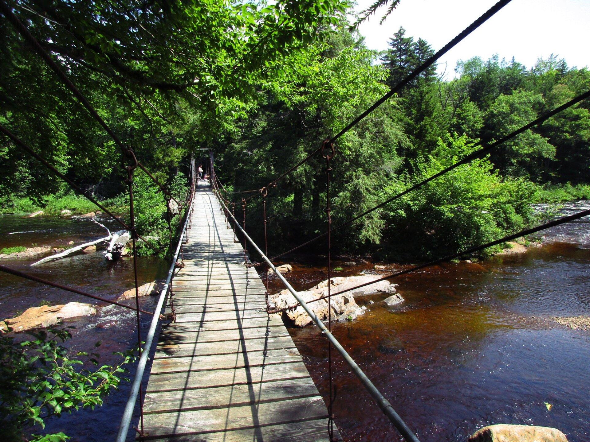
Whitehouse Suspension Bridge ...
Taken on Sunday July 16, 2017 at Whitehouse, NY.
More about Whitehouse, NY...
West River Road currently goes 7 miles from Wells to the old ghost town of Whitehouse, complete with two historic chimneys and several campsites. A scenic area, with views of the West Branch of Sacanadaga River and Dugaway Mountain. There is an old cementary located up there, along with one of the biggest pedestrian suspension bridges in Adirondacks. The Northville-Placid Trail also runs about a 1/4 mile from Whitehouse, and is frequently accessed from the Whitehouse Parking Area.
Although a long distance trail many people use the Northville-Placid Trail to access the wilderness for day trips. The Whitehouse Trailhead is used for short hikes across a unique suspension bridge over the West Branch of the Sacandaga River. Other popular destinations from Whitehouse include Big Eddy, Mud Lake, and Hamilton Lake Stream.
While the state has been trying to close off West River Road since the initial purchase of Whitehouse in the early 1970s, as early as 1972 it was proposed to be added to Silver Lake Wilderness. The latest 2006 Silver Lake Wilderness Unit Management Plan also calls for closure of the road, but no action has been taken, the road is still well maintained by the Town of Wells all the way out Whitehouse.
http://www.dec.ny.gov/lands/100874.html
Maps and Interactives
White House, NY
West River Road (Whitehouse) Campsites
White House Campsites – Overlaid On Aerial Photo From 1942
Sacandaga Primitive Area – Whitehouse Campsites
Big Eddy Trail
... photos, maps and other content from from Whitehouse, NY.
1 Comment
I hiked from the West River Rd ,Whitehouse (where it dead ends) to the Suspension Foot Bridge and nearby Leanto today…it was the first tyme ive been back there in 21 years!!! MEMORIES ABOUNDED! Its a relatively flat, easy walk…took me 1 hour to do this 2.3 mile trek one way…was wonderful to experience that crazy bridge’ again!!!❤️. Two questions: where is the old cemetery? AND there is a unmarked but well trod trail /jeep road that goes off to the left about 10 min in to this hike…where does that go to?? (i am thinking of going back to explore that trail…worth a hike?) Beautifully marked trail and well kept up (thank you!) and NO LITTER!!👍🏻👍🏻
I think that’s the old road to the Big Eddy Tentsite at the intersection of Hamilton Lake Stream and West Branch Sacandaga River.
I think i have figured it out…about that side trail to the left about 10 min into the suspension foot bridge…might be the “trail” to Big Eddy?? correct? worth the hike???
thank you!!
It’s been a while but I believe that is correct.
6/6/21…Today I revisited Whitehouse NY…(near Wells, NY) Today I found the longer suspended pedestrian footbridge over the West Branch of Sacandaga River, and the old stone fireplace chimney that stands at the entrance to that bridge!! One word describes it all: MAJESTIC!!! Beautiful workmanship on both !!! But that bridge…well, THAT really had me stunned! That bridge was erected when? and to be in the beautiful sturdy shape that it is still today!!? Obviously they do not make things like THAT anymore!!I can only imagine the years of beating that bridge has withstood…with people constantly walking over it and not to mention all the river floodings after winter snow melts and rainstorms!!’ THAT IS ONE STURDY AND WELL BUILT BRIDGE!!! Shame on the state of NY if they ever tear it down and construct a “new” bridge in its place!! YOU CAN NEVER BUILD A FINER,STRONGER, MORE ELEGANT bridge as the one thats there now and has BEEN there for YEARS!!! LEAVE IT BE!! In my eyes THAT is a historical landmark!! Today , alone, I met 13 different people that had come there just to experience that bridge!! , me included!!! SO, LEAVE THAT BRIDGE ALONE, ITS UNIQUE AND PEOPLE TRAVEL MILES TO SEE AND EXPERIENCE IT!
Next week, I hope to find the old graveyard (finally got decent directions to find it) and I want to find the Big Eddy!🤞🏻❤️ Stay tuned!
Can someone please include directions on the fastest trail to get to the bridge? I found this helpful site but 2.5miles may be a bit long for my group.
Thanks,
Bridgehunter Sandmeister
It’s only about a half mile from the end of West River Road. But the road may be closed, which makes it about 2.5 miles.
http://mapper.acme.com/?ll=43.37297,-74.43552&z=18&t=S
The road is open. I visited there on 10/10/22.
Hi,
I found the bridge at this lat/long: 43.373833, -74.434730 and when you enter those coordinates on Google and zoom in, you can see the bridge perpendicular to River Road. It doesn’t however, look like it’s at the end of the road but a little bit before that. Andy or Peter, can you please clarify the best place to start walking from on River Road as I have family with me who cannot walk the 2.5 miles but can do the 0.5mile hike.
Thanks,
Bridge-lover Sandy
The road ends before that. The trail that connects the Northville – Placid Trail to parking area follows the old road. It is gated off by old boulders that were installed in the early 1970s when the area was added to the Silver Silver Lake Wilderness.
In the summer when the road is open it’s a 0.5 mile walk but in the spring/winter when the road is closed it’s 2.5 miles. I’ve been told the past few years it’s been open again.