Greenville – Bryants Plaza Expansions, 1997, 2001, 2004, 2009, 2013, 2016, 2021
A series of aerial photos showing the various expansions of the Bryants Plaza.
A series of aerial photos showing the various expansions of the Bryants Plaza.
There are 229 summits in New York State greater then 3,000 feet elevation.
| Tallest Peak | Summit Name | Elevation | County | USGS Topo Map Name | State Land | Trail | Location |
|---|---|---|---|---|---|---|---|
| 1 | Mount Marcy | 5,344 | Essex | Mount Marcy | High Peaks Wilderness | NA | 44.112733, -73.9237833 |
| 2 | Algonquin Peak | 5,105 | Essex | North Elba | High Peaks Wilderness | Algonquin Trail | 44.1436636, -73.9865357 |
| 3 | Mount Haystack | 4,924 | Essex | Mount Marcy | High Peaks Wilderness | Haystack Trail Via Barklet Ridge | 44.1056093, -73.9004196 |
| 4 | Mount Skylight | 4,908 | Essex | Mount Marcy | High Peaks Wilderness | Skylight Trail | 44.0994987, -73.9306986 |
| 5 | Basin Mountain | 4,852 | Essex | Mount Marcy | High Peaks Wilderness | State Range Trail | 44.1211639, -73.8862527 |
| 6 | Iroquois Peak | 4,829 | Essex | North Elba | High Peaks Wilderness | Iroquois Herd Path Via Boundary Peak | 44.1369973, -73.9982027 |
| 7 | Boundary Peak | 4,826 | Essex | North Elba | High Peaks Wilderness | Iroquois Herd Path Via Boundary Peak | 44.1397749, -73.9937582 |
| 8 | Whiteface Mountain | 4,816 | Essex | Lake Placid | Whiteface Mountain Ski Center | Whiteface Landing To Whiteface Mtn. Trail | 44.3658804, -73.9026456 |
| 9 | Dix Mountain | 4,813 | Essex | Dix Mountain | High Peaks Wilderness | Elk Lake To Dix Mountain Trail | 44.0822756, -73.7862471 |
| 10 | Gray Peak | 4,800 | Essex | Mount Marcy | High Peaks Wilderness | Mount Marcy Trail Via Opalescent River | 44.1114427, -73.9348658 |
| 11 | Schofield Cobble | 4,744 | Essex | Mount Marcy | High Peaks Wilderness | NA | 44.1089427, -73.9270876 |
| 12 | Little Marcy | 4,728 | Essex | Mount Marcy | High Peaks Wilderness | Van Hoevenberg Trail To Marcy | 44.1197753, -73.910976 |
| 13 | Gothics | 4,724 | Essex | Keene Valley | High Peaks Wilderness | Beaver Meadow Falls Trail | 44.1281079, -73.8570849 |
| 14 | Mount Colden | 4,708 | Essex | North Elba | High Peaks Wilderness | Mount Colden Via Lake Arnold | 44.1269976, -73.9598674 |
| 15 | Beck-horn | 4,695 | Essex | Dix Mountain | High Peaks Wilderness | Elk Lake To Dix Mountain Trail | 44.0800534, -73.7845802 |
| 16 | Little Haystack | 4,678 | Essex | Mount Marcy | High Peaks Wilderness | Haystack Trail Via Slant Rock | 44.1103313, -73.9004197 |
| 17 | Giant Mountain | 4,623 | Essex | Rocky Peak Ridge | Giant Mountain Wilderness | North Trail To Giant Mtn. | 44.161165, -73.720279 |
| 18 | Mount Redfield | 4,603 | Essex | Mount Marcy | High Peaks Wilderness | Mt Redfield Trail | 44.094777, -73.949866 |
| 19 | Santanoni Peak | 4,596 | Essex | Santanoni Peak | High Peaks Wilderness | Bradley Pond Trail | 44.0822811, -74.1309855 |
| 20 | Wright Peak | 4,564 | Essex | North Elba | High Peaks Wilderness | Wright Peak Spur Trail | 44.1517187, -73.9801468 |
| 21 | Nippletop | 4,554 | Essex | Dix Mountain | High Peaks Wilderness | Nipple Top Trail | 44.0892202, -73.8159708 |
| 22 | Saddleback Mountain | 4,534 | Essex | North Elba | High Peaks Wilderness | State Range Trail | 44.1264414, -73.8748634 |
| 23 | Panther Peak | 4,455 | Essex | Santanoni Peak | High Peaks Wilderness | Bradley Pond Trail | 44.0983915, -74.132097 |
| 24 | Rocky Peak | 4,403 | Essex | Rocky Peak Ridge | Giant Mountain Wilderness | East Trail To Giant Mtn. Via Rocky Peak Ridge | 44.1542177, -73.7051718 |
| 25 | Macomb Mountain | 4,396 | Essex | Dix Mountain | High Peaks Wilderness | Macomb-E. Dix Trail | 44.0517211, -73.7801349 |
| 26 | Hough Peak | 4,393 | Essex | Dix Mountain | High Peaks Wilderness | S. Dix-Hough Trail | 44.0694981, -73.7776352 |
| 27 | Mount Marshall | 4,380 | Essex | Street Mountain | High Peaks Wilderness | Mt Marshall Trail | 44.1275538, -74.0118142 |
| 28 | Armstrong Mountain | 4,360 | Essex | Keene Valley | High Peaks Wilderness | Adk Range Trail | 44.1347741, -73.8490291 |
| 29 | Seward Mountain | 4,327 | Franklin | Ampersand Lake | High Peaks Wilderness | Seymour Mountain Herd Path | 44.1597799, -74.1993239 |
| 30 | Allen Mountain | 4,321 | Essex | Mount Marcy | High Peaks Wilderness | Mt Redfield Trail | 44.0708892, -73.9395871 |
| 31 | Table Top Mountain | 4,295 | Essex | North Elba | High Peaks Wilderness | Table Top Mountain Trail | 44.143663, -73.9070876 |
| 32 | Big Slide Mountain | 4,232 | Essex | Keene Valley | High Peaks Wilderness | Big Slide Trail | 44.1822721, -73.8704202 |
| 33 | Esther Mountain | 4,232 | Essex | Franklin Falls | Wilmington Wild Forest | Esther Mt Trail | 44.3869916, -73.8898673 |
| 34 | MacIntyre Mountains | 4,193 | Essex | Street Mountain | High Peaks Wilderness | Mt Marshall Trail | 44.1308868, -74.008203 |
| 35 | Lower Wolfjaw Mountain | 4,190 | Essex | Keene Valley | High Peaks Wilderness | W.a. White Trail | 44.1483845, -73.8326399 |
| 36 | Upper Wolfjaw Mountain | 4,190 | Essex | Keene Valley | High Peaks Wilderness | Adk Range Trail | 44.1406072, -73.8451402 |
| 37 | Slide Mountain | 4,167 | Ulster | Peekamoose Mountain | Slide Mountain Wilderness | Burroughs Range Trail-Wittenberg-Cornell | 41.9987034, -74.3862617 |
| 38 | Phelps Mountain | 4,137 | Essex | North Elba | High Peaks Wilderness | Phelps Mtn. Trail | 44.1569957, -73.9209775 |
| 39 | Cascade Mountain | 4,094 | Essex | Keene Valley | High Peaks Wilderness | Casade Mountain Trail | 44.2186594, -73.860143 |
| 40 | South Dix | 4,088 | Essex | Dix Mountain | High Peaks Wilderness | Macomb-E. Dix Trail | 44.060054, -73.7743014 |
| 41 | Lookout Mountain | 4,078 | Essex | Franklin Falls | Whiteface Mountain Ski Center | Esther Mt Trail | 44.3778249, -73.887645 |
| 42 | Donaldson Mountain | 4,062 | Franklin | Ampersand Lake | High Peaks Wilderness | Seymour Mountain Herd Path | 44.1539471, -74.210991 |
| 43 | Seymour Mountain | 4,055 | Franklin | Ampersand Lake | High Peaks Wilderness | Seymour Mountain Herd Path | 44.1578347, -74.1721003 |
| 44 | Colvin Range | 4,049 | Essex | Dix Mountain | High Peaks Wilderness | Colvin Trail | 44.0939424, -73.8345829 |
| 45 | Mount Colvin | 4,049 | Essex | Dix Mountain | High Peaks Wilderness | Colvin Trail | 44.0939424, -73.8345829 |
| 46 | Hunter Mountain | 4,045 | Greene | Hunter | Hunter-West Kill Wilderness | Spruceton Trail | 42.1778662, -74.2304216 |
| 47 | Mount Emmons | 4,022 | Franklin | Ampersand Lake | High Peaks Wilderness | Northville-Placid Trail | 44.1436698, -74.2140464 |
| 48 | Street Mountain | 4,022 | Essex | Street Mountain | High Peaks Wilderness | Street Mountain Trail | 44.1797741, -74.0437616 |
| 49 | Grace Peak | 4,006 | Essex | Dix Mountain | High Peaks Wilderness | Macomb-E. Dix Trail | 44.0653314, -73.7573564 |
| 50 | Yard Mountain | 3,999 | Essex | North Elba | High Peaks Wilderness | Big Slide Trail Via Yard Mtn. | 44.1747725, -73.8845874 |
| 51 | MacNaughton Mountain | 3,983 | Essex | Street Mountain | High Peaks Wilderness | Wall Face Ponds Trail | 44.1397768, -74.064317 |
| 52 | Dial Mountain | 3,980 | Essex | Dix Mountain | High Peaks Wilderness | Leach Trail | 44.1058859, -73.7959703 |
| 53 | Blake Peak | 3,976 | Essex | Dix Mountain | High Peaks Wilderness | Pinnacle Trail | 44.081443, -73.844583 |
| 54 | Green Mountain | 3,976 | Essex | Rocky Peak Ridge | Giant Mountain Wilderness | North Trail To Giant Mtn. | 44.182272, -73.714858 |
| 55 | Black Dome | 3,973 | Greene | Freehold | Windham-Blackhead Range Wilderness | Blackhead Range Trail | 42.2700864, -74.1226382 |
| 56 | Thomas Cole Mountain | 3,944 | Greene | Hensonville | Windham-Blackhead Range Wilderness | Blackhead Range Trail | 42.2709196, -74.1365275 |
| 57 | Cliff Mountain | 3,940 | Essex | Mount Marcy | High Peaks Wilderness | Mount Marcy Trail Via Opalescent River | 44.1031102, -73.9751452 |
| 58 | McDonnel Mountain | 3,940 | Essex | Mount Marcy | High Peaks Wilderness | Mt Redfield Trail | 44.0803332, -73.9340315 |
| 59 | Blackhead | 3,930 | Greene | Freehold | Windham-Blackhead Range Wilderness | Blackhead Mountain Spur Trail | 42.2678644, -74.1045818 |
| 60 | West Kill Mountain | 3,891 | Greene | Lexington | Hunter-West Kill Wilderness | Devil’s Path | 42.1678663, -74.2895904 |
| 61 | Doubletop Mountain | 3,875 | Ulster | Seager | NA | Seager Big Indian Trail | 42.0275913, -74.5282095 |
| 62 | Nye Mountain | 3,871 | Essex | Street Mountain | High Peaks Wilderness | Nye Mountain Trail | 44.1931062, -74.0240387 |
| 63 | Kilburn Mountain | 3,868 | Essex | Lake Placid | Sentinel Range Wilderness | Copperas Owen Pond Trl | 44.3028247, -73.8818114 |
| 64 | Moose Mountain | 3,868 | Essex | McKenzie Mountain | Mckenzie Mountain Wilderness | Mckenzie Mtn. Trail | 44.3506029, -74.0032049 |
| 65 | Howard Mountain | 3,852 | Essex | North Elba | High Peaks Wilderness | Klondike Notch Trail | 44.1583844, -73.8912539 |
| 66 | Cornell Mountain | 3,848 | Ulster | Phoenicia | Slide Mountain Wilderness | Burroughs Range Trail-Wittenberg-Cornell | 42.0014812, -74.3568163 |
| 67 | Graham Mountain | 3,848 | Ulster | Seager | NA | Seager Big Indian Trail | 42.0392576, -74.5495986 |
| 68 | Plateau Mountain | 3,845 | Greene | Hunter | Indian Head Wilderness | Devil’s Path | 42.1378671, -74.1743088 |
| 69 | McKenzie Mountain | 3,842 | Essex | McKenzie Mountain | Mckenzie Mountain Wilderness | Mckenzie Mtn. Trail | 44.3361593, -74.0320951 |
| 70 | Rist Mountain | 3,839 | Essex | Mount Marcy | High Peaks Wilderness | Boreas Road | 44.027559, -73.987366 |
| 71 | Sentinel Mountain | 3,835 | Essex | Keene | Sentinel Range Wilderness | Winch Pond | 44.3061581, -73.8523658 |
| 72 | Lyon Mountain | 3,829 | Clinton | Moffitsville | Chazy Highlands Wild Forest | New Lyon Mountain Trail | 44.7036537, -73.8645877 |
| 73 | T R Mountain | 3,829 | Essex | North Elba | High Peaks Wilderness | Lake Arnold Crossover | 44.143941, -73.9354222 |
| 74 | Snowy Mountain | 3,825 | Hamilton | Snowy Mountain | NA | Snowy Mt | 43.7003432, -74.3859856 |
| 75 | Table Mountain | 3,819 | Ulster | Peekamoose Mountain | Slide Mountain Wilderness | Peekamoose-Table Trail | 41.9587036, -74.4048739 |
| 76 | Peekamoose Mountain | 3,812 | Ulster | Peekamoose Mountain | Slide Mountain Wilderness | Peekamoose-Table Trail | 41.9531481, -74.398207 |
| 77 | Avalanche Mountain | 3,809 | Essex | North Elba | High Peaks Wilderness | Avalanche Pass Trail | 44.1361639, -73.9695903 |
| 78 | Averill Peak | 3,806 | Clinton | Lyon Mountain | Chazy Highlands Wild Forest | New Lyon Mountain Trail | 44.6928208, -73.8809768 |
| 79 | Sugarloaf Mountain | 3,806 | Greene | Hunter | Indian Head Wilderness | Devil’s Path | 42.1312006, -74.1501414 |
| 80 | Couchsachraga Peak | 3,793 | Essex | Santanoni Peak | High Peaks Wilderness | Cold River Horse Trail | 44.0956146, -74.1601539 |
| 81 | Boreas Mountain | 3,779 | Essex | Mount Marcy | NA | Gulf Brook Road | 44.0031138, -73.8806937 |
| 82 | Wittenberg Mountain | 3,766 | Ulster | Phoenicia | Slide Mountain Wilderness | Burroughs Range Trail-Wittenberg-Cornell | 42.0081478, -74.3473716 |
| 83 | Panther Mountain | 3,763 | Hamilton | Snowy Mountain | NA | Snowy Mt | 43.7367317, -74.3907093 |
| 84 | Burroughs Range | 3,760 | Ulster | Phoenicia | Slide Mountain Wilderness | Burroughs Range Trail-Wittenberg-Cornell | 42.0084255, -74.3476494 |
| 85 | Blue Mountain | 3,750 | Hamilton | Blue Mountain Lake | Blue Mountain Wild Forest | Blue Mountain Trail | 43.8725634, -74.4009917 |
| 86 | Porter Mountain | 3,750 | Essex | Keene Valley | High Peaks Wilderness | Porter Mountain Trail Via Marcy Field | 44.2153262, -73.8434754 |
| 87 | Wakely Mountain | 3,750 | Hamilton | Wakely Mountain | Wakely Mountain Primitive Area | Wakely Mountain Trail | 43.7358986, -74.5151595 |
| 88 | Little Nippletop | 3,720 | Essex | Mount Marcy | High Peaks Wilderness | Elk Lake To Marcy Trail | 44.0853327, -73.9201422 |
| 89 | Wallface Mountain | 3,720 | Essex | Street Mountain | High Peaks Wilderness | Indian Pass Trail | 44.1378317, -74.0365378 |
| 90 | Panther Mountain | 3,714 | Ulster | Shandaken | Slide Mountain Wilderness | Giant Ledge-Panther Mountian-Fox Hollow Trail | 42.0564799, -74.3945946 |
| 91 | Balsam Lake Mountain | 3,707 | Ulster | Seager | Balsam Lake Mountain Wild Forest | Balsam Lake Mountain Trail | 42.0459236, -74.5940438 |
| 92 | Henderson Mountain | 3,707 | Essex | Mount Adams | High Peaks Wilderness | Bradley Pond Trail | 44.0978353, -74.0976509 |
| 93 | Hoffman Mountain | 3,701 | Essex | Blue Ridge | Hoffman Notch Wilderness | Hoffman Notch Trail | 43.9114489, -73.8168 |
| 94 | Lone Mountain | 3,697 | Ulster | Peekamoose Mountain | Slide Mountain Wilderness | Peekamoose-Table Trail | 41.9692592, -74.3893177 |
| 95 | Big Indian Mountain | 3,694 | Ulster | Shandaken | Big Indian Wilderness | Pine Hill West Branch Trail | 42.0350915, -74.4965421 |
| 96 | Hurricane Mountain | 3,688 | Essex | Rocky Peak Ridge | Hurricane Mountain Wilderness | East Hurricane Mtn Trial | 44.235326, -73.7106926 |
| 97 | Friday Mountain | 3,681 | Ulster | West Shokan | Slide Mountain Wilderness | Burroughs Range Trail-Wittenberg-Cornell | 41.9875924, -74.3620944 |
| 98 | Rusk Mountain | 3,678 | Greene | Lexington | Rusk Mountain Wild Forest | Spruceton Trail | 42.2006434, -74.2770897 |
| 99 | Cheney Cobble | 3,674 | Essex | Mount Marcy | High Peaks Wilderness | East River Trail | 44.0445021, -73.9648654 |
| 100 | Lewey Mountain | 3,665 | Hamilton | Snowy Mountain | West Canada Lake Wilderness | Sucker Brook Trail | 43.6642328, -74.4412649 |
| 101 | Seward Mountains | 3,665 | Franklin | Ampersand Lake | High Peaks Wilderness | Calkins Creek Truck Trail | 44.1561694, -74.2148801 |
| 102 | Santanoni Mountains | 3,661 | Essex | Santanoni Peak | High Peaks Wilderness | Bradley Pond Trail | 44.0881144, -74.138486 |
| 103 | Buell Mountain | 3,652 | Hamilton | Snowy Mountain | NA | Snowy Mt | 43.7161764, -74.4065426 |
| 104 | High Peak | 3,645 | Greene | Kaaterskill Clove | Kaaterskill Wild Forest | Kaaterskill High Peak Trail | 42.1620334, -74.0801381 |
| 105 | Little Whiteface Mountain | 3,638 | Essex | Lake Placid | Whiteface Mountain Ski Center | Whiteface Landing To Whiteface Mtn. Trail | 44.3558804, -73.891534 |
| 106 | Burtons Peak | 3,632 | Essex | Keene Valley | NA | The Brothers Trail | 44.1925, -73.8586111 |
| 107 | Fir Mountain | 3,629 | Ulster | Shandaken | Big Indian Wilderness | Pine Hill West Branch Trail | 42.0275916, -74.4690414 |
| 108 | Twin Mountain | 3,629 | Greene | Hunter | Indian Head Wilderness | Devil’s Path | 42.1256453, -74.1290294 |
| 109 | Little Moose Mountain | 3,609 | Hamilton | Wakely Mountain | Little Moose Wilderness | Otter Brook Trail | 43.6700663, -74.5707151 |
| 110 | Balsam Mountain | 3,606 | Ulster | Shandaken | Big Indian Wilderness | Pine Hill West Branch Trail | 42.0909235, -74.4882082 |
| 111 | Calamity Mountain | 3,606 | Essex | Mount Adams | High Peaks Wilderness | Calamity Brook Trail | 44.1028328, -74.0043132 |
| 112 | Sunrise Mountain | 3,606 | Essex | Dix Mountain | High Peaks Wilderness | Elk Lake To Dix Mountain Trail | 44.0247778, -73.7904124 |
| 113 | Balsam Cap | 3,602 | Ulster | West Shokan | Slide Mountain Wilderness | Burroughs Range Trail-Wittenberg-Cornell | 41.9770369, -74.3573722 |
| 114 | Stewart Mountain | 3,602 | Essex | Keene | Sentinel Range Wilderness | Winch Pond | 44.3261581, -73.8562549 |
| 115 | North Dome | 3,596 | Greene | Lexington | Hunter-West Kill Wilderness | Devil’s Path | 42.1734217, -74.3490366 |
| 116 | Pillsbury Mountain | 3,589 | Hamilton | Spruce Lake | West Canada Lake Wilderness | Pillsbury Mountain Trail | 43.580901, -74.5120992 |
| 117 | Slide Mountain | 3,586 | Essex | Lake Placid | Sentinel Range Wilderness | Barkeater Cliffs Campsite Trail | 44.2767136, -73.8862561 |
| 118 | Eagle Mountain | 3,573 | Ulster | Seager | Big Indian Wilderness | Pine Hill West Branch Trail | 42.0620352, -74.50932 |
| 119 | Dun Brook Mountain | 3,563 | Hamilton | Dun Brook Mountain | NA | Deer Pond Road | 43.890897, -74.3187666 |
| 120 | Saddleback Mountain | 3,560 | Essex | Jay Mountain | Jay Mountain Wilderness | Jay Mountain Trail | 44.2953258, -73.6676367 |
| 121 | Indian Head Mountain | 3,553 | Greene | Woodstock | Indian Head Wilderness | Devil’s Path | 42.116201, -74.1145846 |
| 122 | Fishing Brook Mountain | 3,550 | Essex | Dun Brook Mountain | Blue Mountain Wild Forest | Deer Pond Road | 43.9342303, -74.2946002 |
| 123 | Mount Sherrill | 3,550 | Greene | Lexington | Hunter-West Kill Wilderness | Devil’s Path | 42.1756439, -74.3729262 |
| 124 | Gooseberry Mountain | 3,540 | Essex | Keene Valley | High Peaks Wilderness | Orebed Brook Trail | 44.1367187, -73.8731969 |
| 125 | Bearpen Mountain | 3,530 | Delaware | Prattsville | Bearpen Mountain State Forest | Access Trail | 42.2734189, -74.4840396 |
| 126 | Vly Mountain | 3,530 | Greene | West Kill | Bearpen Mountain State Forest | Snowmobile Trail | 42.2453645, -74.4459834 |
| 127 | Windham High Peak | 3,527 | Greene | Hensonville | Windham-Blackhead Range Wilderness | Escarpment Trail | 42.3148069, -74.1434718 |
| 128 | Halcott Mountain | 3,524 | Greene | West Kill | Halcott Mountain Wild Forest | Condon Hollow Rd. | 42.1800882, -74.4379281 |
| 129 | Mount Adams | 3,520 | Essex | Mount Adams | High Peaks Wilderness | Mt Adams Trail | 44.0867231, -74.0257027 |
| 130 | Pitchoff Mountain | 3,501 | Essex | North Elba | Sentinel Range Wilderness | Pitchoff Mountain Trail | 44.2375474, -73.8776443 |
| 131 | Noonmark Mountain | 3,491 | Essex | Keene Valley | High Peaks Wilderness | Stimson Trail | 44.1289404, -73.7720809 |
| 132 | Rocky Mountain | 3,478 | Ulster | West Shokan | Slide Mountain Wilderness | Peekamoose-Table Trail | 41.9728703, -74.3726505 |
| 133 | Little Santanoni Mountain | 3,471 | Essex | Santanoni Peak | High Peaks Wilderness | Moose Pond Horse Trail | 44.0731156, -74.1670981 |
| 134 | Spotted Mountain | 3,461 | Essex | Underwood | High Peaks Wilderness | Macomb-E. Dix Trail | 44.0769975, -73.7440228 |
| 135 | Manbury Mountain | 3,455 | Hamilton | Wakely Mountain | Little Moose Wilderness | Otter Brook Trail | 43.6653442, -74.5532143 |
| 136 | Blue Ridge Mountain | 3,451 | Essex | Blue Ridge | Hoffman Notch Wilderness | Hoffman Notch Trail | 43.9247817, -73.8148558 |
| 137 | Roundtop | 3,451 | Delaware | Prattsville | Bearpen Mountain State Forest | Ski Run Road | 42.2939737, -74.4904283 |
| 138 | Roundtop Mountain | 3,451 | Greene | Kaaterskill Clove | Kaaterskill Wild Forest | Kaaterskill High Peak Trail | 42.1684222, -74.094583 |
| 139 | Olderbark Mountain | 3,438 | Greene | Bearsville | Indian Head Wilderness | Mink Hollow Trail | 42.1142565, -74.1909765 |
| 140 | Puffer Mountain | 3,438 | Hamilton | Bullhead Mountain | Siamese Ponds Wilderness | Puffer Pond Brook Trail | 43.6617318, -74.1993082 |
| 141 | Morgan Mountain | 3,432 | Essex | Wilmington | Wilmington Wild Forest | Cooper Kill Trail | 44.4186582, -73.8593108 |
| 142 | Wolf Pond Mountain | 3,425 | Essex | Cheney Pond | NA | Gulf Brook Road | 43.9892253, -73.8781933 |
| 143 | Stoppel Point | 3,422 | Greene | Kaaterskill Clove | Windham-Blackhead Range Wilderness | Escarpment Trail | 42.2250879, -74.0651364 |
| 144 | Huntersfield Mountain | 3,419 | Greene | Ashland | Huntersfield State Forest | Huntersfield Access Trail #8/Long Path Access | 42.355638, -74.3465339 |
| 145 | Cellar Mountain | 3,405 | Hamilton | Wakely Mountain | Moose River Plains Wild Forest | Cellar Pond Trail | 43.7122879, -74.5429375 |
| 146 | Haynes Mountain | 3,405 | Ulster | Seager | Big Indian Wilderness | Pine Hill West Branch Trail | 42.0792571, -74.5079309 |
| 147 | Sawtooth Mountains | 3,402 | Franklin | Street Mountain | High Peaks Wilderness | Northville-Placid Trail | 44.1928314, -74.1134874 |
| 148 | Bear Den Mountain | 3,389 | Essex | Dix Mountain | High Peaks Wilderness | Leach Trail | 44.1194964, -73.792915 |
| 149 | Pinnacle | 3,389 | Essex | Dix Mountain | High Peaks Wilderness | Pinnacle Trail Spur To Summit | 44.0583887, -73.8640277 |
| 150 | Vanderwhacker Mountain | 3,389 | Essex | Vanderwhacker Mountain | Vanderwhacker Mountain Wild Forest | Vanderwhacker Firetower Trail | 43.8983963, -74.0959781 |
| 151 | Jay Mountain | 3,379 | Essex | Jay Mountain | Jay Mountain Wilderness | Jay Mountain Trail | 44.3125477, -73.685693 |
| 152 | Spruce Top | 3,379 | Greene | Hunter | NA | Devil’s Path | 42.1506447, -74.1679195 |
| 153 | Spruce Mountain | 3,376 | Ulster | Shandaken | Big Indian Wilderness | Phoenicia East Branch Trail | 42.0175919, -74.4498744 |
| 154 | Belle Ayr Mountain | 3,373 | Ulster | Shandaken | Belleayre Mountain Ski Center | NA | 42.1159229, -74.4979304 |
| 155 | Evergreen Mountain | 3,369 | Greene | Lexington | Rusk Mountain Wild Forest | Devil’s Path | 42.2117542, -74.3079238 |
| 156 | Hedgehog Mountain | 3,366 | Essex | Keene Valley | High Peaks Wilderness | Rooster Comb And Hedgehog Trail | 44.159495, -73.8109724 |
| 157 | Balsam Mountain | 3,353 | Greene | West Kill | Hunter-West Kill Wilderness | Condon Hollow Rd. | 42.1836992, -74.387371 |
| 158 | Kempshall Mountain | 3,350 | Hamilton | Kempshall Mountain | High Peaks Wilderness | Northville-Placid Trail | 44.0236734, -74.3271041 |
| 159 | Buck Mountain | 3,346 | Hamilton | Snowy Mountain | West Canada Lake Wilderness | Snowy Mt | 43.6947879, -74.4368212 |
| 160 | Mount Pisgah | 3,340 | Delaware | Margaretville | NA | Mountain Brook Road | 42.2211973, -74.7357125 |
| 161 | MacDonough Mountain | 3,320 | Essex | Jay Mountain | Jay Mountain Wilderness | Jay Mountain Trail | 44.3050482, -73.644025 |
| 162 | Debar Mountain | 3,317 | Franklin | Debar Mountain | Debar Mountain Wild Forest | Debar Mountain Trail | 44.6033852, -74.2204351 |
| 163 | Bullhead Mountain | 3,314 | Warren | Bullhead Mountain | Siamese Ponds Wilderness | John Pond Crossover Trail | 43.7017316, -74.1804199 |
| 164 | Laramore Mountain | 3,314 | Essex | Keene Valley | High Peaks Wilderness | Casade Mountain Trail | 44.2258813, -73.8501427 |
| 165 | Tripod Mountain | 3,307 | Essex | Rocky Peak Ridge | Giant Mountain Wilderness | Hopkin Via Direct Trail | 44.1983824, -73.736248 |
| 166 | Metcalf Mountain | 3,304 | Hamilton | Blue Mountain Lake | Blue Ridge Wilderness | Gould Road | 43.7522873, -74.4957146 |
| 167 | Wyman Mountain | 3,304 | Essex | Underwood | High Peaks Wilderness | Macomb-E. Dix Trail | 44.0581093, -73.7445779 |
| 168 | Jay Mountains | 3,297 | Essex | Jay Mountain | Jay Mountain Wilderness | Jay Mountain Trail | 44.308659, -73.6704147 |
| 169 | Eleventh Mountain | 3,294 | Warren | Bakers Mills | Siamese Ponds Wilderness | Bog Meadow Trail | 43.6142322, -74.0720783 |
| 170 | Schultice Mountain | 3,284 | Delaware | Roxbury | NA | Ski Run Road | 42.3186948, -74.5157062 |
| 171 | Cellar Mountain | 3,281 | Hamilton | Snowy Mountain | West Canada Lake Wilderness | Sucker Brook Trail | 43.6411776, -74.4443199 |
| 172 | Plattekill Mountain | 3,268 | Delaware | Hobart | Plattekill State Forest | Mountain Brook/ Harold Roberts Access Trail | 42.2667522, -74.6482102 |
| 173 | South Pond Mountain | 3,258 | Hamilton | South Pond Mountain | Siamese Ponds Wilderness | County Line Brook Trail | 43.5900656, -74.2204175 |
| 174 | Hemlock Mountain | 3,248 | Ulster | Shandaken | Big Indian Wilderness | Phoenicia East Branch Trail | 42.0128698, -74.4390407 |
| 175 | Peaked Mountain | 3,235 | Essex | Jay Mountain | Hurricane Mountain Wilderness | Soda Range Trail | 44.2656034, -73.6993039 |
| 176 | Onteora Mountain | 3,232 | Greene | Hunter | NA | Blackhead Range Trail | 42.2223098, -74.1679184 |
| 177 | Kitty Cobble | 3,225 | Hamilton | Wakely Mountain | West Canada Lake Wilderness | Otter Brook Trail | 43.6295111, -74.6229377 |
| 178 | Baldwin Hill | 3,218 | Essex | Franklin Falls | Mckenzie Mountain Wilderness | Esther Mt Trail | 44.3847694, -73.9195905 |
| 179 | Richmond Mountain | 3,218 | Greene | Ashland | Mount Pisgah State Forest | Long Path Hiking Trail | 42.367582, -74.270976 |
| 180 | Squaw Mountain | 3,218 | Hamilton | Indian Lake | NA | Snowy Mt | 43.7270094, -74.3420956 |
| 181 | Dug Mountain | 3,215 | Hamilton | Kunjamuk River | NA | Long Pond Trail | 43.583122, -74.345146 |
| 182 | Hamilton Mountain | 3,215 | Hamilton | Wells | Silver Lake Wilderness | West River Road | 43.412013, -74.3673645 |
| 183 | Mount Alton | 3,212 | Essex | Lake Placid | Mckenzie Mountain Wilderness | Whiteface Mountain Trail | 44.3717139, -73.9662589 |
| 184 | Utsayantha Mountain | 3,209 | Delaware | Stamford | NA | Ward Allen Road | 42.3992472, -74.5895953 |
| 185 | Van Wyck Mountain | 3,202 | Ulster | Peekamoose Mountain | Slide Mountain Wilderness | Phoenicia East Branch Trail | 41.9523147, -74.4354304 |
| 186 | Colonels Chair | 3,199 | Greene | Hunter | NA | Colonel’s Chair Trail | 42.2006434, -74.2306991 |
| 187 | Gore Mountain | 3,199 | Warren | Gore Mountain | Gore Mountain Ski Center | Schaefer Trail | 43.6764539, -74.035134 |
| 188 | Chase Mountain | 3,192 | Essex | Rocky Peak Ridge | Hurricane Mountain Wilderness | North Hurricane Trail | 44.2417145, -73.7248599 |
| 189 | Knob Lock Mountain | 3,192 | Essex | Rocky Peak Ridge | Giant Mountain Wilderness | Hurricane Trail From 9n | 44.2003271, -73.7073583 |
| 190 | McGregor Mountain | 3,192 | Delaware | Stamford | Stamford Fp Detached Parcel | Relay Public Forest Access Road | 42.3900808, -74.5790396 |
| 191 | Weston Mountain | 3,192 | Essex | Jay Mountain | Hurricane Mountain Wilderness | Soda Range Trail | 44.2642144, -73.7079152 |
| 192 | Burnt Knob | 3,189 | Greene | Freehold | Windham-Blackhead Range Wilderness | Escarpment Trail | 42.3020297, -74.1190264 |
| 193 | Burgess Mountain | 3,189 | Hamilton | Rock Lake | NA | Bear Trap Brook Trail | 43.7520092, -74.3565416 |
| 194 | North Mountain | 3,186 | Greene | Kaaterskill Clove | Windham-Blackhead Range Wilderness | Escarpment Trail | 42.2175881, -74.0487469 |
| 195 | Payne Mountain | 3,182 | Hamilton | Snowy Mountain | Moose River Plains Wild Forest | Northville-Placid Trail | 43.7231211, -74.4951582 |
| 196 | Hopkins Mountain | 3,169 | Essex | Rocky Peak Ridge | Giant Mountain Wilderness | Hopkins Mtn. Via Spread Eagle Mtn. | 44.1833828, -73.7490257 |
| 197 | Spruce Lake Mountain | 3,163 | Hamilton | Spruce Lake Mountain | West Canada Lake Wilderness | Northville-Placid Trail | 43.5120126, -74.6532121 |
| 198 | Tongue Mountain | 3,159 | Hamilton | Dun Brook Mountain | NA | Northville-Placid Trail | 43.9114522, -74.3454349 |
| 199 | Catamount Mountain | 3,153 | Clinton | Wilmington | Taylor Pond Wild Forest | Catamount Trail | 44.459214, -73.8723668 |
| 200 | Wildcat Mountain | 3,153 | Ulster | Peekamoose Mountain | Slide Mountain Wilderness | Pine Hill West Branch Trail | 41.9775924, -74.4759867 |
| 201 | White Man Mountain | 3,146 | Delaware | Roxbury | NA | Access Trail | 42.2845295, -74.5340406 |
| 202 | Bradley Mountain | 3,140 | Hamilton | Wakely Mountain | Blue Ridge Wilderness | Cellar Pond Trail | 43.7378431, -74.5546055 |
| 203 | Overlook Mountain | 3,136 | Ulster | Woodstock | Overlook Mountain Wild Forest | Firetower Spur | 42.0850905, -74.0931954 |
| 204 | Mount Tamarac | 3,127 | Essex | McKenzie Mountain | Mckenzie Mountain Wilderness | Jackrabbit Trail | 44.3267144, -74.0204281 |
| 205 | Mount Morris | 3,117 | Franklin | Tupper Lake | NA | Goodman Mountain Trail | 44.1595046, -74.475168 |
| 206 | Acra Point | 3,110 | Greene | Freehold | Windham-Blackhead Range Wilderness | Escarpment Trail | 42.2964745, -74.0998591 |
| 207 | Round Mountain | 3,107 | Essex | Keene Valley | High Peaks Wilderness | Weston Trail Spur To Round Mt | 44.1317179, -73.7515245 |
| 208 | Cave Mountain | 3,104 | Greene | Hensonville | Elm Ridge Wild Forest | North Face Trail | 42.2859185, -74.2462543 |
| 209 | Pete Gay Mountain | 3,097 | Warren | Gore Mountain | NA | Schaefer Trail | 43.6903427, -74.0443015 |
| 210 | Plattekill Mountain | 3,091 | Greene | Woodstock | Indian Head Wilderness | Overlook Trail | 42.1073123, -74.0865281 |
| 211 | Mount Andrew | 3,081 | Essex | Mount Adams | High Peaks Wilderness | Bradley Pond Trail | 44.0564482, -74.093483 |
| 212 | County Line Mountain | 3,081 | Hamilton | South Pond Mountain | Siamese Ponds Wilderness | Siamese Ponds Trail | 43.6114543, -74.2006952 |
| 213 | High Point | 3,074 | Ulster | West Shokan | Sundown Wild Forest | Ashokan High Point | 41.9248149, -74.2879263 |
| 214 | Rose Mountain | 3,074 | Ulster | West Kill | NA | Rochester Hollow | 42.1506445, -74.4379284 |
| 215 | Cowan Mountain | 3,068 | Delaware | Hobart | NA | Relay Public Forest Access Road | 42.3450825, -74.6498756 |
| 216 | Round Top | 3,068 | Delaware | Hobart | Plattekill State Forest | Mountain Brook/ Harold Roberts Access Trail | 42.2714741, -74.6832109 |
| 217 | Churchill Mountain | 3,064 | Delaware | Stamford | NA | Relay Public Forest Access Road | 42.388692, -74.6098738 |
| 218 | Irish Mountain | 3,064 | Delaware | Roxbury | NA | Ski Run Road | 42.3356386, -74.5262617 |
| 219 | Swart Mountain | 3,061 | Hamilton | Lake Pleasant | Silver Lake Wilderness | West River Road | 43.3967355, -74.3815314 |
| 220 | Scarface Mountain | 3,058 | Essex | McKenzie Mountain | Saranac Lakes Wild Forest | Scarface Mountain Trail | 44.2647717, -74.0737646 |
| 221 | T Lake Mountain | 3,058 | Hamilton | Piseco Lake | West Canada Lake Wilderness | T Lake Trail | 43.4470133, -74.5770967 |
| 222 | Bailey Hill | 3,054 | Essex | Cheney Pond | Hoffman Notch Wilderness | Hoffman Notch Trail | 43.9108943, -73.9026366 |
| 223 | Bald Peak | 3,054 | Essex | Rocky Peak Ridge | Giant Mountain Wilderness | East Trail To Giant Mtn. Via Rocky Peak Ridge | 44.1597731, -73.6654114 |
| 224 | Little Rocky Mountain | 3,051 | Greene | Bearsville | Indian Head Wilderness | Warner Creek Trail | 42.1150898, -74.2040325 |
| 225 | Denman Mountain | 3,048 | Sullivan | Claryville | NA | Denman Mountain Snowmobile Trail | 41.90287, -74.5396005 |
| 226 | Woodhull Mountain | 3,045 | Ulster | Peekamoose Mountain | NA | Phoenicia East Branch Trail | 41.9459259, -74.4637647 |
| 227 | Barkaboom Mountain | 3,005 | Delaware | Arena | Dry Brook Ridge Wild Forest | Touch-Me-Not-Trail | 42.0717554, -74.7201571 |
| 228 | Stony Creek Mountain | 3,002 | Franklin | Stony Creek Mountain | High Peaks Wilderness | Ampersand Mountain Trail | 44.222002, -74.2659949 |
| 229 | Van Dorrien Mountain | 3,002 | Franklin | Ampersand Lake | High Peaks Wilderness | Ampersand Mountain Trail | 44.2222766, -74.1704351 |
An interactive map and listing of the 280 peaks over 3,000 feet elevation listed in the Open Street Map database for New York State.
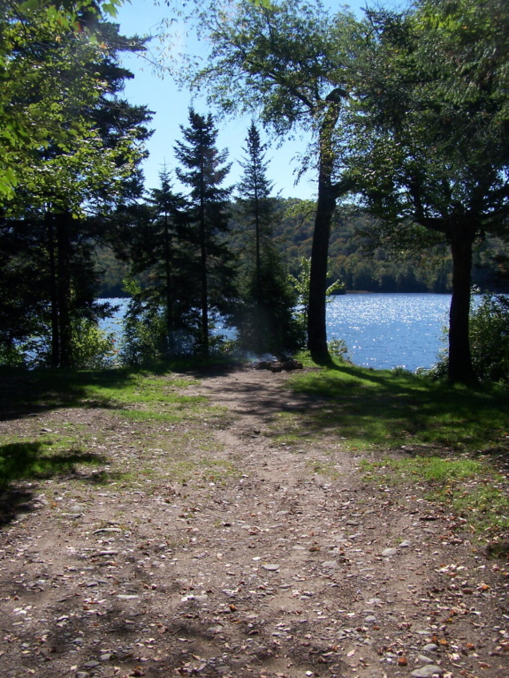
16 1/2 miles and 30 miles north of Forestport, the North Lake Reservoir serves as the headwaters to the Black River in a large reservoir maintained by the NYS Canal Authority for supplying a steady supply of water to Black River and Erie Canal via the former Black River Canal. Half of sites are on Black River Wild Forest, while most of the northernly sites are on a conservation easement. There is a sign-on booth for these campsites, permits are needed for stays over three nights. These are primitive campsites, though some of the sites along the eastern side, are accessible by a vehicle with a smaller camper on top. Boats with motors are allowed on this lake, so in summer months it may be not a quiet water. Most sites are on the water.
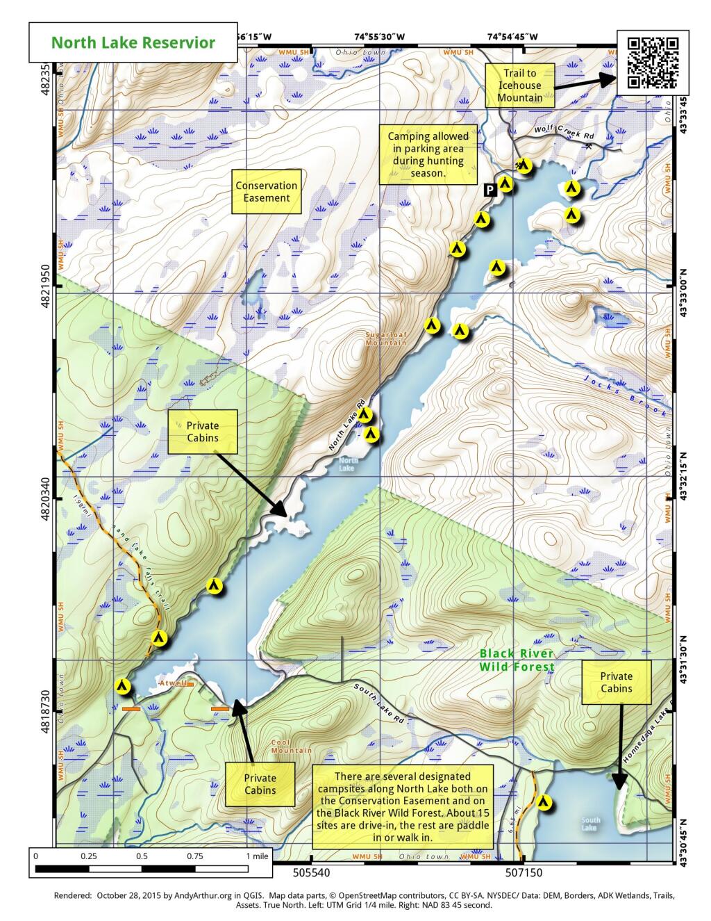
Easement campsites are based on memory and were hand-drawn so they may be somewhat inaccurate.
| Name | Latitude | Longitude |
| North Lake Designated Campsite #2 | 43.52293019 | -74.94933889 |
| North Lake Designated Campsite #3 | 43.52335381 | -74.94934207 |
| North Lake Designated Campsite #4 | 43.52506095 | -74.94695943 |
| North Lake Designated Campsite #6 | 43.52569387 | -74.94579628 |
| North Lake Designated Campsite #7 | 43.52600551 | -74.94534407 |
| North Lake Designated Campsite #8 | 43.52775406 | -74.94410338 |
| North Lake Designated Campsite #9 | 43.52800073 | -74.94327684 |
| North Lake Designated Campsite #10 | 43.52898888 | -74.94247143 |
| North Lake Designated Campsite #11 | 43.52977988 | -74.9403576 |
| Easement Campsite | 43.61254681 | -75.05263918 |
| Easement Campsite | 43.51529059 | -74.90967 |
| Easement Campsite | 43.48088879 | -75.01092893 |
| Easement Campsite | 43.54038222 | -74.92580987 |
| Easement Campsite | 43.61805247 | -75.03272826 |
| Easement Campsite | 43.61368033 | -75.09087559 |
| Easement Campsite | 43.61053007 | -75.02701572 |
| Easement Campsite | 43.58885404 | -74.999126 |
| Easement Campsite | 43.59254977 | -75.0887635 |
| Easement Campsite | 43.59171534 | -75.00692959 |
Here is a list of coordinates for the Indian Lake Islands Campground (Fee) and Lewey Lake Campground (Fee). More details from the DEC website.
| Campground | Site | Driveway | Shade | Latitude | Longitude |
| Indian Lake Islands | 1 | (None) | (Partial ) | 43.7304748395054 | -74.2877932167853 |
| Indian Lake Islands | 2 | (None) | (Partial ) | 43.7224530757475 | -74.2907624839568 |
| Indian Lake Islands | 3 | (None) | (Partial ) | 43.7190491138668 | -74.2940872824686 |
| Indian Lake Islands | 4 | (None) | (Partial ) | 43.7171199750046 | -74.2951363500399 |
| Indian Lake Islands | 5 | (None) | (Partial ) | 43.7159390292911 | -74.296792430288 |
| Indian Lake Islands | 6 | (None) | (Partial ) | 43.7137209154048 | -74.2992816338604 |
| Indian Lake Islands | 7 | (None) | (Partial ) | 43.7086902361217 | -74.3044716184849 |
| Indian Lake Islands | 8 | (None) | (Partial ) | 43.7066170967467 | -74.3063428212781 |
| Indian Lake Islands | 9 | (None) | (Partial ) | 43.706484373826 | -74.309012568379 |
| Indian Lake Islands | 10 | (None) | (Partial ) | 43.7041133917479 | -74.3108869570744 |
| Indian Lake Islands | 11 | (None) | (Partial ) | 43.697346802679 | -74.3247139479059 |
| Indian Lake Islands | 12 | (None) | (Partial ) | 43.6934233534827 | -74.315934250817 |
| Indian Lake Islands | 13 | (None) | (Partial ) | 43.6938317599398 | -74.3095682765959 |
| Indian Lake Islands | 14 | (None) | (Partial ) | 43.6913056913982 | -74.3104180397371 |
| Indian Lake Islands | 15 | (None) | (Partial ) | 43.6877472510145 | -74.3207508140818 |
| Indian Lake Islands | 16 | (None) | (Partial ) | 43.6879799999189 | -74.3198289615071 |
| Indian Lake Islands | 17 | (None) | (Partial ) | 43.6872673095493 | -74.3201653062021 |
| Indian Lake Islands | 18 | (None) | (Partial ) | 43.6868443760804 | -74.3211549484078 |
| Indian Lake Islands | 19 | (None) | (Partial ) | 43.6800228460593 | -74.3197875603731 |
| Indian Lake Islands | 20 | (None) | (Partial ) | 43.6793373937581 | -74.3247190213537 |
| Indian Lake Islands | 21 | (None) | (Partial ) | 43.6810192238513 | -74.3271292597841 |
| Indian Lake Islands | 22 | (None) | (Partial ) | 43.6805443385533 | -74.3273971705849 |
| Indian Lake Islands | 23 | (None) | (Partial ) | 43.6800709967613 | -74.3279276612134 |
| Indian Lake Islands | 24 | (None) | (Partial ) | 43.6775663157946 | -74.3314349429213 |
| Indian Lake Islands | 25 | (None) | (Partial ) | 43.6771809454088 | -74.3307171030939 |
| Indian Lake Islands | 26 | (None) | (Partial ) | 43.6600950542325 | -74.3339914761212 |
| Indian Lake Islands | 27 | (None) | (Partial ) | 43.6623719767926 | -74.3322598972669 |
| Indian Lake Islands | 28 | (None) | (Partial ) | 43.6575398626981 | -74.337038506508 |
| Indian Lake Islands | 29 | (None) | (Partial ) | 43.6566182393285 | -74.3342267801279 |
| Indian Lake Islands | 30 | (None) | (Partial ) | 43.6539829236887 | -74.3316966403176 |
| Indian Lake Islands | 31 | (None) | (Partial ) | 43.6522937620085 | -74.3361775393021 |
| Indian Lake Islands | 32 | (None) | (Partial ) | 43.6668538380581 | -74.341005433188 |
| Indian Lake Islands | 33 | (None) | (Partial ) | 43.6641596734641 | -74.3447759888232 |
| Indian Lake Islands | 34 | (None) | (Partial ) | 43.6744752460176 | -74.3406594587518 |
| Indian Lake Islands | 35 | (None) | (Partial ) | 43.6763325751765 | -74.3405078298866 |
| Indian Lake Islands | 36 | (None) | (Partial ) | 43.6751048173184 | -74.3424249794205 |
| Indian Lake Islands | 37 | (None) | (Partial ) | 43.6726882040652 | -74.3447488483478 |
| Indian Lake Islands | 38 | (None) | (Partial ) | 43.671219530231 | -74.3462089234796 |
| Indian Lake Islands | 39 | (None) | (Partial ) | 43.6658110160362 | -74.3502713526553 |
| Indian Lake Islands | 40 | (None) | (Partial ) | 43.6668806076464 | -74.3456652959817 |
| Indian Lake Islands | 41 | (None) | (Partial ) | 43.6589425226124 | -74.3489672499976 |
| Indian Lake Islands | 42 | (None) | (Partial ) | 43.6461754070921 | -74.3577661306475 |
| Indian Lake Islands | 43 | (None) | (Partial ) | 43.6435487359423 | -74.3566787343966 |
| Indian Lake Islands | 44 | (None) | (Partial ) | 43.6420329888729 | -74.3582695228578 |
| Indian Lake Islands | 45 | (None) | (Partial ) | 43.6426696252334 | -74.3613463998048 |
| Indian Lake Islands | 46 | (None) | (Partial ) | 43.6398608445525 | -74.36176979162 |
| Indian Lake Islands | 47 | (None) | (Partial ) | 43.6383868178017 | -74.3623102353059 |
| Indian Lake Islands | 48 | (None) | (Partial ) | 43.6343029677954 | -74.3647806409216 |
| Indian Lake Islands | 49 | (None) | (Partial ) | 43.6243422964902 | -74.3729530691659 |
| Indian Lake Islands | 50 | (None) | (Partial ) | 43.6190266118137 | -74.3767465989883 |
| Indian Lake Islands | 51 | (None) | (Partial ) | 43.6138131801135 | -74.3818499714923 |
| Indian Lake Islands | 52 | (None) | (Partial ) | 43.6562041049367 | -74.3704560068939 |
| Indian Lake Islands | 53 | (None) | (Partial ) | 43.6494681775961 | -74.3846914479894 |
| Indian Lake Islands | 54 | (None) | (Partial ) | 43.6514550856348 | -74.3831537190584 |
| Indian Lake Islands | 55 | (None) | (Partial ) | 43.651176948613 | -74.3868066171873 |
| Lewey Lake | 1 | (None) | (Partial ) | 43.6562024310996 | -74.3859352040697 |
| Lewey Lake | 2 | (None) | (Partial ) | 43.6560080429272 | -74.386114371147 |
| Lewey Lake | 3 | (None) | (Partial ) | 43.6555994338734 | -74.3863285289305 |
| Lewey Lake | 4 | (None) | (Partial ) | 43.6553409492017 | -74.3869939588461 |
| Lewey Lake | 5 | (Back-In ) | (Partial ) | 43.6549944505377 | -74.3872402889378 |
| Lewey Lake | 6 | (None) | (Partial ) | 43.6547358088616 | -74.3875232167508 |
| Lewey Lake | 7 | (None) | (Partial ) | 43.6555627626506 | -74.3883763623652 |
| Lewey Lake | 8 | (None) | (Partial ) | 43.6553264387608 | -74.3887331268337 |
| Lewey Lake | 9 | (None) | (Partial ) | 43.6551699020518 | -74.3884978054947 |
| Lewey Lake | 10 | (Back-In ) | (Partial ) | 43.6554939292582 | -74.3888692371441 |
| Lewey Lake | 11 | (Back-In ) | (Partial ) | 43.6556169965957 | -74.3887170551251 |
| Lewey Lake | 12 | (Back-In ) | (Partial ) | 43.6545401285823 | -74.3878158251703 |
| Lewey Lake | 13 | (Back-In ) | (Partial ) | 43.6543208717219 | -74.3879588081455 |
| Lewey Lake | 14 | (Back-In ) | (Partial ) | 43.6541063200042 | -74.3882028588317 |
| Lewey Lake | 16 | (Back-In ) | (Partial ) | 43.6533270463703 | -74.3890618274419 |
| Lewey Lake | 17 | (Back-In ) | (Partial ) | 43.6536643355513 | -74.3888746674892 |
| Lewey Lake | 18 | (Back-In ) | (Partial ) | 43.6538492339655 | -74.3887021752128 |
| Lewey Lake | 19 | (Back-In ) | (Partial ) | 43.653681673951 | -74.388552945847 |
| Lewey Lake | 20 | (Back-In ) | (Partial ) | 43.653456870117 | -74.3883911731743 |
| Lewey Lake | 21 | (Back-In ) | (Partial ) | 43.653222432248 | -74.388209813196 |
| Lewey Lake | 23 | (Back-In ) | (Partial ) | 43.6531357242574 | -74.388033516963 |
| Lewey Lake | 24 | (Back-In ) | (Partial ) | 43.6528033447699 | -74.3887803769451 |
| Lewey Lake | 25 | (Back-In ) | (Partial ) | 43.6532196336188 | -74.388577320074 |
| Lewey Lake | 27 | (Back-In ) | (Partial ) | 43.6529120186575 | -74.3889676038093 |
| Lewey Lake | 29 | (Back-In ) | (Partial ) | 43.6527997073202 | -74.3893493421477 |
| Lewey Lake | 30 | (Back-In ) | (Partial ) | 43.6525419392994 | -74.3892600860596 |
| Lewey Lake | 31 | (Back-In ) | (Partial ) | 43.6523132664271 | -74.3902070762933 |
| Lewey Lake | 33 | (Back-In ) | (Partial ) | 43.6525673731442 | -74.3895616820917 |
| Lewey Lake | 34 | (Back-In ) | (Partial ) | 43.6492545820769 | -74.3893065206245 |
| Lewey Lake | 35 | (Back-In ) | (Partial ) | 43.6508892227624 | -74.3893752618756 |
| Lewey Lake | 36 | (Back-In ) | (Partial ) | 43.6507135666242 | -74.3886027442071 |
| Lewey Lake | 37 | (Back-In ) | (Partial ) | 43.6509786873957 | -74.388285084342 |
| Lewey Lake | 38 | (Back-In ) | (Partial ) | 43.6507288662767 | -74.3879004711796 |
| Lewey Lake | 39 | (Back-In ) | (Partial ) | 43.6508545527112 | -74.3873479998761 |
| Lewey Lake | 40 | (Back-In ) | (Partial ) | 43.6505376052044 | -74.3868853324626 |
| Lewey Lake | 41 | (Back-In ) | (Partial ) | 43.6505965848651 | -74.3863335387737 |
| Lewey Lake | 42 | (Back-In ) | (Partial ) | 43.6503928785904 | -74.3865521520601 |
| Lewey Lake | 43 | (Back-In ) | (Partial ) | 43.6509805975001 | -74.3859752872169 |
| Lewey Lake | 44 | (Back-In ) | (Partial ) | 43.6507507080316 | -74.3857545266411 |
| Lewey Lake | 45 | (Back-In ) | (Partial ) | 43.6502700695766 | -74.3858644139635 |
| Lewey Lake | 46 | (Back-In ) | (Partial ) | 43.6502911704183 | -74.3862447827049 |
| Lewey Lake | 47 | (Back-In ) | (Partial ) | 43.6499932410208 | -74.385775369415 |
| Lewey Lake | 48 | (Back-In ) | (Partial ) | 43.6501671207898 | -74.3862132375143 |
| Lewey Lake | 49 | (Back-In ) | (Partial ) | 43.649549553744 | -74.3856683424932 |
| Lewey Lake | 50 | (Back-In ) | (Partial ) | 43.649966522813 | -74.386123415084 |
| Lewey Lake | 51 | (Back-In ) | (Partial ) | 43.64926880754 | -74.385736821138 |
| Lewey Lake | 52 | (Back-In ) | (Partial ) | 43.6495131664191 | -74.3859902369415 |
| Lewey Lake | 53 | (Back-In ) | (Partial ) | 43.6490594925732 | -74.3857980091705 |
| Lewey Lake | 54 | (Back-In ) | (Partial ) | 43.6492327723884 | -74.3861243275344 |
| Lewey Lake | 55 | (Back-In ) | (Partial ) | 43.648899195221 | -74.3861146008927 |
| Lewey Lake | 56 | (Back-In ) | (Partial ) | 43.6487871388043 | -74.3865422481799 |
| Lewey Lake | 57 | (Back-In ) | (Partial ) | 43.6490827420732 | -74.3865786094433 |
| Lewey Lake | 58 | (Back-In ) | (Partial ) | 43.6487509249503 | -74.3868969451581 |
| Lewey Lake | 59 | (Back-In ) | (Partial ) | 43.6489757309761 | -74.3870586997987 |
| Lewey Lake | 60 | (Back-In ) | (Partial ) | 43.648661597741 | -74.3871209487514 |
| Lewey Lake | 61 | (Back-In ) | (Partial ) | 43.6487070089981 | -74.3875929241082 |
| Lewey Lake | 62 | (Back-In ) | (Partial ) | 43.6484255936806 | -74.3875367291766 |
| Lewey Lake | 63 | (Back-In ) | (Partial ) | 43.6484749247307 | -74.3878511839453 |
| Lewey Lake | 64 | (Back-In ) | (Partial ) | 43.6482309213949 | -74.387663376046 |
| Lewey Lake | 65 | (Back-In ) | (Partial ) | 43.6479052355313 | -74.3882375383448 |
| Lewey Lake | 67 | (Back-In ) | (Partial ) | 43.6480674354201 | -74.3882752613386 |
| Lewey Lake | 68 | (Back-In ) | (Partial ) | 43.6482636181653 | -74.3884307490016 |
| Lewey Lake | 69 | (Back-In ) | (Partial ) | 43.6483329508238 | -74.3889221631754 |
| Lewey Lake | 70 | (Back-In ) | (Partial ) | 43.6484214744842 | -74.3885472557372 |
| Lewey Lake | 71 | (Back-In ) | (Partial ) | 43.6485923320595 | -74.3893132305463 |
| Lewey Lake | 72 | (Back-In ) | (Partial ) | 43.6486609923734 | -74.3887876057122 |
| Lewey Lake | 73 | (Back-In ) | (Partial ) | 43.6488249806771 | -74.3891599552364 |
| Lewey Lake | 74 | (Back-In ) | (Partial ) | 43.6489020524226 | -74.3893166545299 |
| Lewey Lake | 75 | (Back-In ) | (Partial ) | 43.6488364719736 | -74.3895272905218 |
| Lewey Lake | 76 | (Back-In ) | (Partial ) | 43.6487225473048 | -74.3896071849629 |
| Lewey Lake | 77 | (Back-In ) | (Partial ) | 43.6484114953114 | -74.389354432209 |
| Lewey Lake | 78 | (Back-In ) | (Partial ) | 43.6486135264653 | -74.3897132737756 |
| Lewey Lake | 79 | (Back-In ) | (Partial ) | 43.6484114953114 | -74.389354432209 |
| Lewey Lake | 80 | (Back-In ) | (Partial ) | 43.6484316600153 | -74.3897837495296 |
| Lewey Lake | 81 | (Back-In ) | (Partial ) | 43.6482493658706 | -74.3893298280977 |
| Lewey Lake | 82 | (Back-In ) | (Partial ) | 43.6483274184154 | -74.3896702405063 |
| Lewey Lake | 83 | (Back-In ) | (Partial ) | 43.6480393118859 | -74.3892532177941 |
| Lewey Lake | 84 | (Back-In ) | (Partial ) | 43.6481460210081 | -74.3896064613976 |
| Lewey Lake | 85 | (Back-In ) | (Partial ) | 43.6478770421904 | -74.3892023702674 |
| Lewey Lake | 86 | (Back-In ) | (Partial ) | 43.6479599999346 | -74.3895689760199 |
| Lewey Lake | 87 | (Back-In ) | (Partial ) | 43.6478547627806 | -74.3894913035924 |
| Lewey Lake | 88 | (Back-In ) | (Partial ) | 43.6476653559151 | -74.3894694543108 |
| Lewey Lake | 89 | (Back-In ) | (Partial ) | 43.6465796420994 | -74.3878830951514 |
| Lewey Lake | 90 | (Back-In ) | (Partial ) | 43.6464166547287 | -74.3886220941953 |
| Lewey Lake | 91 | (Back-In ) | (Partial ) | 43.6461264370569 | -74.3879362333827 |
| Lewey Lake | 92 | (Back-In ) | (Partial ) | 43.6460700944218 | -74.3886830317875 |
| Lewey Lake | 93 | (Back-In ) | (Partial ) | 43.6457783052293 | -74.3887307535881 |
| Lewey Lake | 94 | (Back-In ) | (Partial ) | 43.6457941322989 | -74.3881887576526 |
| Lewey Lake | 95 | (Back-In ) | (Partial ) | 43.6453738976443 | -74.3887716912407 |
| Lewey Lake | 96 | (Back-In ) | (Partial ) | 43.6451383323739 | -74.3885836944366 |
| Lewey Lake | 97 | (Back-In ) | (Partial ) | 43.6450937957173 | -74.3890731028571 |
| Lewey Lake | 98 | (Back-In ) | (Partial ) | 43.6447522634829 | -74.3888885258902 |
| Lewey Lake | 99 | (Back-In ) | (Partial ) | 43.6448758257383 | -74.3892983928306 |
| Lewey Lake | 100 | (Back-In ) | (Partial ) | 43.6444766060049 | -74.3891889997801 |
| Lewey Lake | 101 | (Back-In ) | (Partial ) | 43.6447155884519 | -74.3896280744818 |
| Lewey Lake | 102 | (Back-In ) | (Partial ) | 43.6443911413052 | -74.3894648954895 |
| Lewey Lake | 103 | (Back-In ) | (Partial ) | 43.644640969072 | -74.3899306453455 |
| Lewey Lake | 104 | (Back-In ) | (Partial ) | 43.6443100466916 | -74.3896792682778 |
| Lewey Lake | 105 | (Back-In ) | (Partial ) | 43.6445450573364 | -74.3903673156228 |
| Lewey Lake | 106 | (Back-In ) | (Partial ) | 43.6442218430019 | -74.3899611305922 |
| Lewey Lake | 107 | (Back-In ) | (Partial ) | 43.6442819553248 | -74.3905116582544 |
| Lewey Lake | 108 | (Back-In ) | (Partial ) | 43.6440041511869 | -74.3902389008548 |
| Lewey Lake | 109 | (Back-In ) | (Partial ) | 43.6440072993199 | -74.3908293690613 |
| Lewey Lake | 110 | (Back-In ) | (Partial ) | 43.6436722524392 | -74.3905440671692 |
| Lewey Lake | 111 | (Back-In ) | (Partial ) | 43.6436941772484 | -74.391081853163 |
| Lewey Lake | 112 | (Back-In ) | (Partial ) | 43.6435213310838 | -74.3908342797345 |
| Lewey Lake | 113 | (Back-In ) | (Partial ) | 43.643533725148 | -74.3913721607107 |
| Lewey Lake | 114 | (Back-In ) | (Partial ) | 43.6433223445442 | -74.3910462427773 |
| Lewey Lake | 115 | (Back-In ) | (Partial ) | 43.643411177599 | -74.391622718015 |
| Lewey Lake | 116 | (Back-In ) | (Partial ) | 43.6431418564056 | -74.3911530423907 |
| Lewey Lake | 117 | (Back-In ) | (Partial ) | 43.6430981942098 | -74.3919014384763 |
| Lewey Lake | 118 | (Back-In ) | (Partial ) | 43.6429436385439 | -74.3915093385338 |
| Lewey Lake | 119 | (Back-In ) | (Partial ) | 43.6425954007563 | -74.3923264121497 |
| Lewey Lake | 120 | (Back-In ) | (Partial ) | 43.642753691304 | -74.3916293530442 |
| Lewey Lake | 121 | (Back-In ) | (Partial ) | 43.6423561343236 | -74.3921319950852 |
| Lewey Lake | 122 | (Back-In ) | (Partial ) | 43.6426687003843 | -74.3917745520774 |
| Lewey Lake | 123 | (Back-In ) | (Partial ) | 43.6424692234731 | -74.3918946613195 |
| Lewey Lake | 124 | (Back-In ) | (Partial ) | 43.6525381902482 | -74.3903428596814 |
| Lewey Lake | 125 | (Back-In ) | (Partial ) | 43.6527107575593 | -74.3905379765597 |
| Lewey Lake | 126 | (Back-In ) | (Partial ) | 43.6525936063472 | -74.3909066359603 |
| Lewey Lake | 128 | (Back-In ) | (Partial ) | 43.652435146533 | -74.3915710018658 |
| Lewey Lake | 130 | (Back-In ) | (Partial ) | 43.6522428085308 | -74.3921372760075 |
| Lewey Lake | 131 | (Back-In ) | (Partial ) | 43.65262218037 | -74.3917987856947 |
| Lewey Lake | 132 | (Back-In ) | (Partial ) | 43.6519884616328 | -74.3926910478604 |
| Lewey Lake | 133 | (Back-In ) | (Partial ) | 43.6524064144964 | -74.3923537012364 |
| Lewey Lake | 134 | (Back-In ) | (Partial ) | 43.6516698395068 | -74.3928058122598 |
| Lewey Lake | 135 | (Back-In ) | (Partial ) | 43.6522611334302 | -74.3927183145996 |
| Lewey Lake | 136 | (Back-In ) | (Partial ) | 43.6515362971243 | -74.3927809096067 |
| Lewey Lake | 137 | (Back-In ) | (Partial ) | 43.6520427514414 | -74.3930448485546 |
| Lewey Lake | 138 | (Back-In ) | (Partial ) | 43.6513837326685 | -74.3927627610359 |
| Lewey Lake | 139 | (Back-In ) | (Partial ) | 43.651771321095 | -74.393073830334 |
| Lewey Lake | 140 | (Back-In ) | (Partial ) | 43.6512450072755 | -74.3926591681817 |
| Lewey Lake | 141 | (Back-In ) | (Partial ) | 43.6514806578101 | -74.3930701951291 |
| Lewey Lake | 142 | (Back-In ) | (Partial ) | 43.6511588649176 | -74.3925878560293 |
| Lewey Lake | 143 | (Back-In ) | (Partial ) | 43.6512942546345 | -74.3929605193171 |
| Lewey Lake | 144 | (Back-In ) | (Partial ) | 43.651034885811 | -74.3925694199481 |
| Lewey Lake | 145 | (Back-In ) | (Partial ) | 43.6511985134041 | -74.3928761800213 |
| Lewey Lake | 146 | (Back-In ) | (Partial ) | 43.6509110819315 | -74.3925837910083 |
| Lewey Lake | 147 | (Back-In ) | (Partial ) | 43.6510744306825 | -74.3928380575372 |
| Lewey Lake | 148 | (Back-In ) | (Partial ) | 43.6507249563543 | -74.3925266103811 |
| Lewey Lake | 149 | (Back-In ) | (Partial ) | 43.6510075196288 | -74.3927993604525 |
| Lewey Lake | 150 | (Back-In ) | (Partial ) | 43.6505764581427 | -74.3923771846 |
| Lewey Lake | 151 | (Back-In ) | (Partial ) | 43.6508931396266 | -74.3927939517889 |
| Lewey Lake | 152 | (Back-In ) | (Partial ) | 43.6501539712455 | -74.3928139724822 |
| Lewey Lake | 153 | (Back-In ) | (Partial ) | 43.6506453217752 | -74.3927833240434 |
| Lewey Lake | 154 | (Back-In ) | (Partial ) | 43.6504826701999 | -74.392660288079 |
| Lewey Lake | 155 | (Back-In ) | (Partial ) | 43.6503944701246 | -74.3922018509199 |
| Lewey Lake | 156 | (Back-In ) | (Partial ) | 43.6502670517585 | -74.3924327989789 |
| Lewey Lake | 157 | (Back-In ) | (Partial ) | 43.6502171749186 | -74.3920133465799 |
| Lewey Lake | 158 | (Back-In ) | (Partial ) | 43.6500655524662 | -74.3921723595017 |
| Lewey Lake | 159 | (Back-In ) | (Partial ) | 43.65010220154 | -74.3918963946763 |
| Lewey Lake | 160 | (Back-In ) | (Partial ) | 43.6498801593201 | -74.3922529700147 |
| Lewey Lake | 161 | (Back-In ) | (Partial ) | 43.6499783628321 | -74.3919042063052 |
| Lewey Lake | 162 | (Back-In ) | (Partial ) | 43.6498642959964 | -74.3919578506314 |
| Lewey Lake | 163 | (Back-In ) | (Partial ) | 43.6497365301035 | -74.3921231830361 |
| Lewey Lake | 164 | (Back-In ) | (Partial ) | 43.6496799855084 | -74.3922418642017 |
| Lewey Lake | 165 | (Back-In ) | (Partial ) | 43.6496332482681 | -74.3924129407801 |
| Lewey Lake | 166 | (Back-In ) | (Partial ) | 43.6497576807574 | -74.3925166743979 |
| Lewey Lake | 167 | (Back-In ) | (Partial ) | 43.6495349395156 | -74.3927420176198 |
| Lewey Lake | 168 | (Back-In ) | (Partial ) | 43.649783733219 | -74.3929363627442 |
| Lewey Lake | 169 | (Back-In ) | (Partial ) | 43.6495607821443 | -74.3931223364114 |
| Lewey Lake | 170 | (Back-In ) | (Partial ) | 43.6499420039304 | -74.3931316221761 |
| Lewey Lake | 171 | (Back-In ) | (Partial ) | 43.6496759293245 | -74.3932720972688 |
| Lewey Lake | 172 | (Back-In ) | (Partial ) | 43.6501760859221 | -74.3932473770535 |
| Lewey Lake | 173 | (Back-In ) | (Partial ) | 43.649848004272 | -74.3933753532189 |
| Lewey Lake | 174 | (Back-In ) | (Partial ) | 43.6504723139811 | -74.3934018781128 |
| Lewey Lake | 175 | (Back-In ) | (Partial ) | 43.6500105506526 | -74.3934787044013 |
| Lewey Lake | 176 | (Pull-Through ) | (Partial ) | 43.6506729402757 | -74.393498286223 |
| Lewey Lake | 177 | (Pull-Through ) | (Partial ) | 43.6503306000313 | -74.393632967762 |
| Lewey Lake | 178 | (Pull-Through ) | (Partial ) | 43.6508973193824 | -74.3935813326933 |
| Lewey Lake | 179 | (Pull-Through ) | (Partial ) | 43.6509749070501 | -74.3938364644253 |
| Lewey Lake | 180 | (Pull-Through ) | (Partial ) | 43.6511403385758 | -74.3935854497481 |
| Lewey Lake | 182 | (Back-In ) | (Partial ) | 43.651440355387 | -74.3935561829589 |
| Lewey Lake | 183 | (Back-In ) | (Partial ) | 43.6516291202832 | -74.3932130628545 |
| Lewey Lake | 184 | (Back-In ) | (Partial ) | 43.6501834954987 | -74.3937459974257 |
| Lewey Lake | 185 | (Back-In ) | (Partial ) | 43.6504412950105 | -74.3938418312205 |
| Lewey Lake | 186 | (Back-In ) | (Partial ) | 43.6505096309504 | -74.3941495496478 |
| Lewey Lake | 187 | (Back-In ) | (Partial ) | 43.6505108131118 | -74.3943726395853 |
| Lewey Lake | 188 | (Back-In ) | (Partial ) | 43.6502945381307 | -74.3940204765682 |
| Lewey Lake | 189 | (Back-In ) | (Partial ) | 43.6504361127886 | -74.3946621101528 |
| Lewey Lake | 190 | (Back-In ) | (Partial ) | 43.6503160298583 | -74.3944795858391 |
| Lewey Lake | 191 | (Back-In ) | (Partial ) | 43.6504046722823 | -74.395023325048 |
| Lewey Lake | 192 | (Back-In ) | (Partial ) | 43.650237709888 | -74.3949856303055 |
| Lewey Lake | 193 | (Back-In ) | (Partial ) | 43.6503107727246 | -74.3952867393724 |
| Lewey Lake | 194 | (Back-In ) | (Partial ) | 43.6505389086426 | -74.3951794622762 |
| Lewey Lake | 195 | (Back-In ) | (Partial ) | 43.6504598223622 | -74.3955411553674 |
| Lewey Lake | 196 | (Back-In ) | (Partial ) | 43.650711537203 | -74.3953877079922 |
| Lewey Lake | 197 | (Back-In ) | (Partial ) | 43.6506604477948 | -74.3956375705903 |
| Lewey Lake | 198 | (Back-In ) | (Partial ) | 43.6508644839223 | -74.3954780403089 |
| Lewey Lake | 199 | (Back-In ) | (Partial ) | 43.6511071204696 | -74.3954099874409 |
| Lewey Lake | 200 | (Back-In ) | (Partial ) | 43.6509038476415 | -74.39571387204 |
| Lewey Lake | 201 | (Back-In ) | (Partial ) | 43.6512421888644 | -74.3957236030087 |
| Lewey Lake | 202 | (Back-In ) | (Partial ) | 43.6510374934892 | -74.3957584655006 |
| Lewey Lake | 203 | (Back-In ) | (Partial ) | 43.6512159603347 | -74.3961700748559 |
| Lewey Lake | 204 | (Back-In ) | (Partial ) | 43.6514019455146 | -74.396201021807 |
| Lewey Lake | 205 | (Back-In ) | (Partial ) | 43.6513460550165 | -74.3964443723559 |
| Lewey Lake | 206 | (Back-In ) | (Partial ) | 43.6515135356203 | -74.3965804953413 |
| Lewey Lake | 207 | (Back-In ) | (Partial ) | 43.6509386316873 | -74.395083584175 |
| Lewey Lake | 208 | (Back-In ) | (Partial ) | 43.6511057320134 | -74.3951475261183 |
| Lewey Lake | 209 | (Back-In ) | (Partial ) | 43.6509513619453 | -74.3947881729673 |
| Lewey Lake | 210 | (Back-In ) | (Partial ) | 43.6511135597002 | -74.3948259154299 |
| Lewey Lake | 211 | (Back-In ) | (Partial ) | 43.6509965733823 | -74.3943283871773 |
| Lewey Lake | 212 | (Back-In ) | (Partial ) | 43.6511304274238 | -74.3944123467805 |
| Lewey Lake | 213 | (Back-In ) | (Partial ) | 43.6507444735048 | -74.3938370645823 |
| Lewey Lake | 214 | (Back-In ) | (Partial ) | 43.6511862101655 | -74.3941493106687 |
| Lewey Lake | 215 | (Back-In ) | (Partial ) | 43.6512797582196 | -74.3938202749566 |
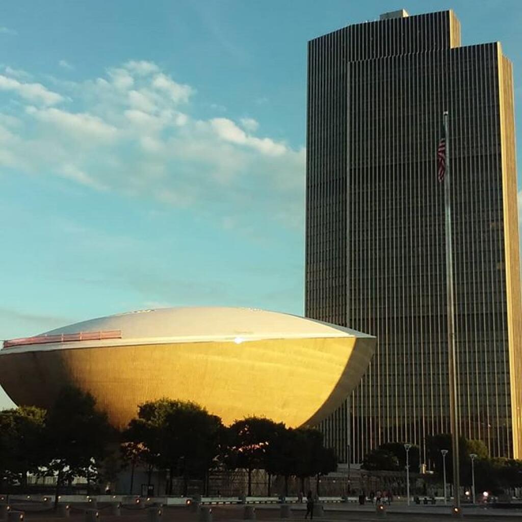
Earlier this week I wrote a small PHP script for analysis of the shadow cast by buildings on the surrounding landscape. To obtain sun position and altitude, it relies on SunCalc PHP which must be included in the script. It goes throughout the year, churning out how much of a shadow a building will produce each hour, in feet and direction. Additionally, the script will calculate the maximum point the shadow will be cast as a set of coordinates.
<?php
// The current values entered into this script currently are for the Empire Plaza.
$latitude = 42.64915;
$longitude = -73.75950;
$height = 610;
$start = strtotime("January 1, 2020 12 AM");
$end = strtotime("December 31, 2020 11 PM");
include("suncalc.php");
// Compass as a Reference
$compass = array(
'north', 'north-northeast', 'northeast',
'east-northeast', 'east', 'east-southeast',
'southeast', 'south-southeast', 'south',
'south-southwest', 'southwest',
'west-southwest', 'west', 'west-northwest',
'northwest', 'north-northwest');
function newPos($lat, $lng, $dist, $dir) {
// Earth Radius in KM
$R = 6378.14;
// distance in feet to KM
$d = (($dist * 0.3048) / 1000);
// Degree to Radian
$lat1 = $lat * (M_PI/180);
$lng1 = $lng * (M_PI/180);
$brng = $dir * (M_PI/180);
// Really Complicated Math (TM) that works based on the HAVERSINE formula from
// https://stackoverflow.com/questions/7222382/get-lat-long-given-current-point-distance-and-bearing
$lat2 = asin(sin($lat1)*cos($d/$R) + cos($lat1)*sin($d/$R)*cos($brng));
$lng2 = $lng1 + atan2(sin($brng)*sin($d/$R)*cos($lat1),cos($d/$R)-sin($lat1)*sin($lat2));
# back to degrees
$lat2 = $lat2 * (180/M_PI);
$lng2 = $lng2 * (180/M_PI);
return "$lat2,$lng2";
}
$output = "Month,Day,Hour,Sun Angle,Sun Position,Sun Pos Name,Shadow Length,Shadow Direction,Shadow Dir Name,Orginal Lat, Original Lng, Maximum Shadow Lat, Maximum Shadow Lng\n";
for ($time = $start; $time &lt; $end; $time += 60*60) { // get sun position for time $timeObj = new DateTime(); $timeObj-&gt;setTimestamp($time);
$sc = new AurorasLive\SunCalc($timeObj, $latitude, $longitude);
$sunPos = $sc-&gt;getSunPosition($timeObj);
// don't include any time when sun is below the horizon
if ($sunPos-&gt;altitude*(180/M_PI) &lt; 0) continue; // add month, day, hour $output .= date('n,j,G,',$time); // get sun altitude $output .= $sunPos-&gt;altitude*(180/M_PI).',';
// get sun position
$output .= 180+$sunPos-&gt;azimuth*(180/M_PI).',';
$output .= $compass[round((180+$sunPos-&gt;azimuth*(180/M_PI))/ 22.5) % 16].',';
// shadow length
$output .= $height/tan(deg2rad($sunPos-&gt;altitude*(180/M_PI))).',';
// shadow direction
$shadowDir = $sunPos-&gt;azimuth*(180/M_PI) + 360;
if ($shadowDir &gt; 360) $shadowDir -= 360;
$output .= $shadowDir.',';
$output .= $compass[round($shadowDir/ 22.5) % 16].',';
// building latitude and longitude
$output .= "$latitude, $longitude,";
// maximum extent of shadow
$output .= newPos($latitude, $longitude, $height/tan(deg2rad($sunPos-&gt;altitude*(180/M_PI))), $shadowDir).",";
$output .= "\n";
}
echo $output;
Here is an example output:
Month,Day,Hour,Sun Angle,Sun Position,Sun Pos Name,Shadow Length,Shadow Direction,Shadow Dir Name,Orginal Lat, Original Lng, Maximum Shadow Lat, Maximum Shadow Lng
1,1,8,4.370562595888,127.16997476055,southeast,7981.2630997694,307.16997476055,northwest,42.64915, -73.7595,42.662350867593,-73.783180446551,
1,1,9,12.464234785715,138.47001937172,southeast,2759.6833421566,318.47001937172,northwest,42.64915, -73.7595,42.654806428356,-73.766311948646,
1,1,10,18.826346377511,151.18871989968,south-southeast,1789.1660233981,331.18871989968,north-northwest,42.64915, -73.7595,42.653442385927,-73.762710054908,
1,1,11,22.92597731207,165.29270254371,south-southeast,1442.2476816852,345.29270254371,north-northwest,42.64915, -73.7595,42.652969571748,-73.76086316453,
1,1,12,24.317973645092,180.27827074558,south,1349.8710413416,0.27827074557518,north,42.64915, -73.7595,42.652845989302,-73.7594755931,
1,1,13,22.827705402895,195.24737437252,south-southwest,1449.1706789769,15.247374372522,north-northeast,42.64915, -73.7595,42.652978239559,-73.758081165062,
1,1,14,18.641667869753,209.31025239405,south-southwest,1808.2272087538,29.310252394054,north-northeast,42.64915, -73.7595,42.653467170112,-73.756204500047,
1,1,15,12.211118961179,221.98033545934,southwest,2818.7133569306,41.980335459338,northeast,42.64915, -73.7595,42.654887013398,-73.752480800429,
1,1,16,4.0670753820534,233.23837174035,southwest,8579.0650125467,53.238371740354,northeast,42.64915, -73.7595,42.663205632648,-73.733908619093,
1,2,8,4.3645441749857,127.03353849744,southeast,7992.3115188513,307.03353849744,northwest,42.64915, -73.7595,42.662327567958,-73.783255965565,
1,2,9,12.476443037614,138.33095911417,southeast,2756.8958218911,318.33095911417,northwest,42.64915, -73.7595,42.654788550435,-73.766323694576,
1,2,10,18.860737296743,151.04916237459,south-southeast,1785.6561891219,331.04916237459,north-northwest,42.64915, -73.7595,42.653428213262,-73.762717935368,
1,2,11,22.985140372821,165.15894624042,south-southeast,1438.1068136859,345.15894624042,north-northwest,42.64915, -73.7595,42.652956261035,-73.760871335783,
1,2,12,24.401639825801,180.15947237405,south,1344.6352402431,0.15947237405339,north,42.64915, -73.7595,42.652831682677,-73.759486067027,
1,2,13,22.932215921968,195.15131682951,south-southwest,1441.810083379,15.151316829514,north-northeast,42.64915, -73.7595,42.652960530629,-73.7580970562,
1,2,14,18.761308368827,209.23956034287,south-southwest,1795.8375075952,29.239560342872,north-northeast,42.64915, -73.7595,42.653440556697,-73.756234277101,
1,2,15,12.340240887742,221.93268535805,southwest,2788.302504508,41.932685358049,northeast,42.64915, -73.7595,42.654829364851,-73.752562956502,
1,2,16,4.2013827926665,233.20922777897,southwest,8303.8756666826,53.209227778967,northeast,42.64915, -73.7595,42.662764126188,-73.734739101558,
Good morning! Happy Thursday. Getting my teeth cleaned this morning.🦷 Lucky me. Next Thursday Save the Pine Bush Turns 42 🦋. Been a long time since Dick Patrick and Mayor Erastus Corning had their public hearing on the Lone Pine Development during the 1978 blizzard when all of state government was shut down but not the city’s planning board hearing at the old Herman Bleecker library downtown. 🌲
Bright and sunny and 18 degrees in Delmar, NY. 🌞 Calm wind. 🍃 Things will start to thaw out at around 1 pm. 🌡️ Without the wind and the bright sun pushing thirty degrees altitude by noon time, not too bad. Indeed the latest forecast predicts weather a few degrees above normal by late afternoon. ♨ Seems like the old heater has kept up fine in my apartment and it’s quite comfortable inside. That said, I think I’ll drive to the dentist just because if I miss the bus I can either drive home or wait inside my truck for the next bus 🚍 so I’m not stuck out in the cold ❄.
Today will be mostly sunny 🌞, with a high of 35 degrees at 3pm. Four degrees above normal, which is similar to a typical day around February 15th. Light and variable wind. I’ll take that for late January. A year ago, we had mostly sunny skies in the morning, which became light snow by afternoon. The high last year was 28 degrees. The record high of 56 was set in 2013. 11 inches of snow fell back in 1966.❄
Hopefully I’ll survive my dentist appointment. 🦷 I really should floss more and I am a bad person for that but I do brush my teeth regularly and the past few years I’ve been getting biyearly cleanings so hopefully I won’t be buck tooth too soon. I haven’t been drinking as much milk lately 🐮 – maybe a gallon a week in favor of apple juice 🍏 which is terrible for my teeth but I get tired of milk and apple juice at least is healthier than beer or soda. I do drink a lot of florinated water 💦 too. I support science and urban water florination and yes the milk I drink is pasteurized as I don’t own my own cow 🐮 and it only takes a little amount of bacteria of the wrong type in the bulk tank to make you very sick, and despite the iodine teat dip and properly stripping teats, cows do lay in the grass, mud and manure all day.
Solar noon 🌞 is at 12:09 pm with sun having an altitude of 29.6° from the due south horizon (-41.2° vs. 6/21). I’m thinking tomorrow will be thirty degrees noontime altitude but only if it’s sunny out will it matter much. I heard the mercury could teach fifty on Monday and The golden hour 🏅 starts at 4:24 pm with the sun in the west-southwest (239°). 📸 The sunset is in the west-southwest (246°) starting at 5:03 pm and lasts for 3 minutes and 10 seconds with dusk around 5:35 pm, which is one minute and 18 seconds later than yesterday. 🌇 At dusk you’ll see the First Quarter 🌓 Moon in the south-southwest (204°) at an altitude of 47° from the horizon, 251,535 miles away. 🚀 The best time to look at the stars is after 6:10 pm. At sunset, look for partly cloudy skies 🌃 and temperatures around the freezing point. There will be a calm wind. Today will have 9 hours and 53 minutes of daytime, an increase of 2 minutes and 16 seconds over yesterday.
Tonight will be partly cloudy 🌤, with a low of 17 degrees at 6am. Two degrees above normal, which is similar to a typical night around February 11th. South wind 3 to 5 mph. Works for me. In 2019, we had mostly clear skies in the evening, which became mostly clear by the early hours of the morning. It got down to -3 degrees. The record low of -26 occurred back in 1948.
I briefly checked the fluids in my truck and they’re all good. ⛽ I haven’t had to add oil since the November oil change at the dealership. I’ve also noticed that the lifter that was clicking has stopped. Maybe the sludge in the engine has fixed the problem. I do doing synthetic oil changes and lately been going to the dealer with the long hours and good price for regular maintenance. Maybe I will be able to get several more years out of the truck. I still will need to get new 35 inch tires probably at the end of the year and probably an alignment and that ain’t cheap but it’s been six years by the end of next year since I jacked up my truck. 🚘
Nothing to celebrate this weekend except maybe the Ground Hawg not seeing his shadow. 🐻 Saturday, a slight chance of snow showers before noon, then a slight chance of rain and snow showers between noon and 1pm, then a slight chance of rain showers after 1pm. Mostly cloudy, with a high near 39. Calm wind. Chance of precipitation is 20%. Sunday, mostly cloudy, with a high near 39. ☁ Typical average high for the weekend is 32 degrees.
🌹🌻🌼Only 49 days remain until the first day of calendar spring!🌹🌻🌼
49 days of winter left, 49 days of winter left. Take one down, pass it around….
As previously noted, next Thursday is Save the Pine Bush Turns 42 🦋 when the sun will be setting at 5:14 pm with dusk at 5:44 pm. On that day in 2019, we had rain and temperatures between 37 and 25 degrees. Typically, the high temperature is 33 degrees. We hit a record high of 55 back in 1991.
Good evening! Clear and 20 degrees in Delmar, NY. There is a north breeze at 8 mph. 🍃. The current wind chill is 8. There is a dusting of snow on the ground. ☃ Things will start to thaw out at Friday around 11 am. 🌡️
It was pretty bitterly cold ❄ after going out with some of my colleagues after work and having some drinks and wings 🍻 and then waiting for the bus to go home. 🚍 The 49 cent wings – ten for $4.90 are a great deal 🍗 and are really good tasting at Public House 42. Plus my colleagues picked up the tab for my birthday 🎂 which was really nice of them to do. I offered to pay but they were really nice. I don’t go out much but it was nice especially at the new Pinto and Hobbs where it was pretty quiet. I hate drinking beer where the crowds and noise are so loud you can’t hear a person five feet away. Even Public House 42 was pretty quiet, they were playing Peter Paul and Mary for a walk.
Tonight will be clear 🌃, with a low of 6 degrees at 4am. Nine degrees below normal. Maximum wind chill around -1 at 5am; North wind 3 to 8 mph. In 2019, we had light snow in the evening, which became mostly clear by the early hours of the morning. It got down to 1 degrees. The record low of -12 occurred back in 1965.
There was at least one if not two homeless people on the street last night at the bus stop. 🚏Seemed like an awful cold night to be on the street. I’ve spent a few single digit nights in the wilderness in the single digits but that’s with warm clothes, a rip roaring fire 🔥 and my propane heater in a hot tent 🎪. The homeless action network was giving out blankets and tarps to the people and probably asking them if they wanted to go to the shelter. One was asking if anybody had keys 🔑 or a knife🔪 to open 🔓 the bag that they were blanket they got came in. I said no because I didn’t know if my key would be sharp enough and I didn’t want to have it stolen and not be able to get in my own house. 🏡 The guy flagged down the homeless van and got in any they helped him open it.
Just reminds me how privileged I am even if it seems like I have very little money 💵 in my bank account at the end of the month. My rent check was withdrawn yesterday. That’s good, I hopefully won’t get evicted for at least another month. 🏡 Done so much damage to my landlords building 🏢 although not all of it is my fault – it’s had moisture problems since I moved in and things were old and thread bare ready to wear through. Plus my muddy boots and gear didn’t help. That said, over the past 12 1/2 years I’ve paid like $80k in rent, always on time and only called the landlord over a handful of times. 💰The rent check cleared while I was drinking to remind me how poor I truly am.💸 At least it was my birthday.
The Snow ❄ Moon is on Sunday, February 9. The darkest hour is at 12:09 am, followed by dawn at 6:44 am, and sun starting to rise at 7:14 am in the east-southeast (114°) and last for 3 minutes and 10 seconds. Sunrise is 57 seconds earlier than yesterday. 🌄 The golden hour ends at 7:56 am with sun in the east-southeast (121°). Tonight will have 14 hours and 7 minutes of darkness, a decrease of 2 minutes and 16 seconds over last night.
Tomorrow will be sunny 🌞, with a high of 32 degrees at 3pm. One degree above normal, which is similar to a typical day around January 31st. Light and variable wind. With the sun it will feel even warmer. Next week might be closer to 50 on Monday. A year ago, we had cloudy skies in the morning, which became light snow by afternoon. The high last year was 28 degrees. The record high of 56 was set in 2013. 11 inches of snow fell back in 1966.❄
Tooth cleaning appointment in the morning. 🦷 I should have done a better job at flossing over the past six months but I’ve been busy and I’m sure I’ll get yelled out gently by my dental hygienist. He’s actually a good guy and very friendly and just tries to nudge me to better dental health. Figuring I didn’t take care of my teeth for a long time it’s good I’m at least getting regular cleanings now.
In four weeks on February 26 the sun will be setting in the west (259°) at 5:40 pm,🌄 which is 36 minutes and 19 seconds later then tonight. In 2019 on that day, we had mostly sunny, snow showers and temperatures between 24 and 15 degrees. Typically, you have temperatures between 38 and 20 degrees. The record high of 63 degrees was set back in 1976.
After I got home I researched the Rensselaer Biotech facility that is supposed to be one of those mechanical biological treatment facilities 🚮that shreds mixed garbage and supposedly breaks it down into compostable materials and recoverable metals. I think the biggest concern is it will process mixed waste rather than source separated organics. I’d rather see much higher prices on mixed waste and that sent to landfills with a priority on source separated organics recovery and dual stream recycling. ♻ Having more bins is a pain but it may be necessary for clean waste recovery.
Looking ahead, February Save the Pine Dinner 🦋 is in 3 weeks, Average High is 40 ☀️ is in 5 weeks, April Fools Day 🤡 is in 9 weeks, Pink Moon 🌕 is in 10 weeks, Tax Day 💰 is in 11 weeks, Earth Day 🌎 is in 12 weeks, Latest Sunset 🌆 is in 21 weeks and Inauguration Day 2021 👴🏻 is in 51 weeks.
🇺🇸🦅Only 113 days remain until the start of Memorial Day Weekend!🦅🇺🇸