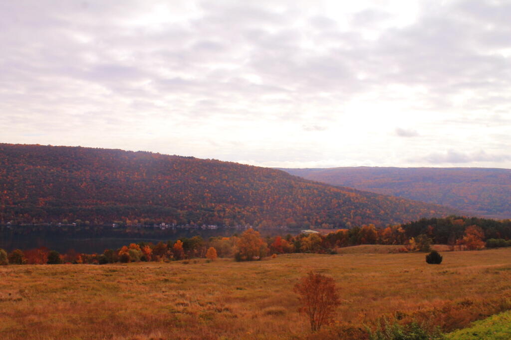
South Hill, Canadaigua Lake, East Hill

Driving out to Brookfield this past weekend, I decided to stop and take a break at Weaver Lake, a public fishing lake. I got some interesting images.
Taken on Saturday April 9, 2011 at Great Western Turnpike.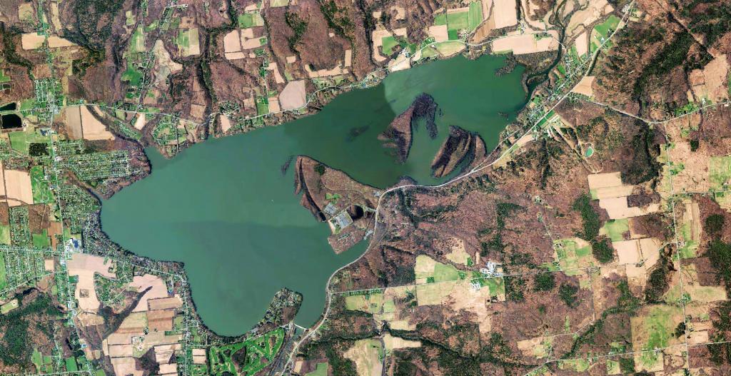
Delta Lake is a water storage reservoir at the end of West Canada Creek that helps regulate the flow of water heading into the Barge Canal/Mohawk River throughout the summer.
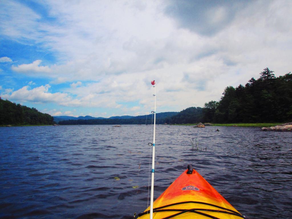
Didn't make it all the way to Canada Lake from Stewart Landing because I was concerned about the weather, although afternoon storms never materialized.
Taken on Saturday June 19, 2021 at Canada Lake.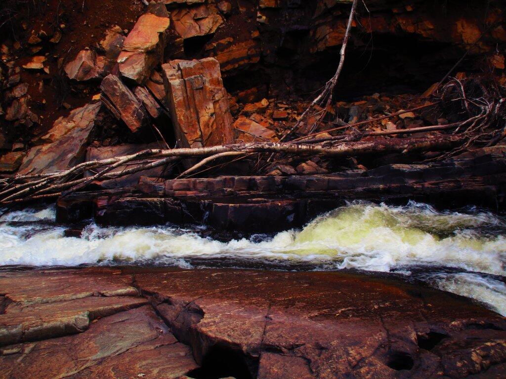
Around Austin Falls, the Sacanadaga River piles into this narrow groove in the rock, as all the water flows out from Lake Pleasant and down to Wells.
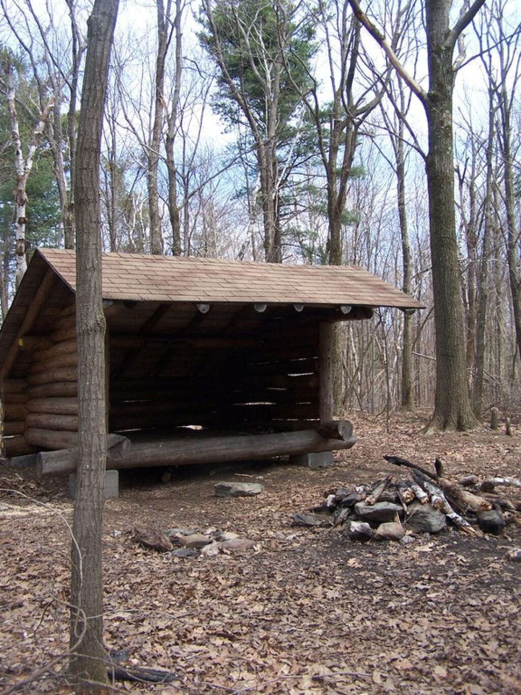
Taken on Thursday July 23, 2020 at Jessup River Wild Forest.East Branch of Sacanadaga River, NY 8 – Roughly 10 campsites along NY 8. These are easily accessed throughout the year, as the road is plowed except when the snow banks are high during the winter. East Branch is not good for fishing due to wide variance in water levels, however there are some nice pools in sections of river for summer swimming. Lots of road noise. Some of the sites have cell service. Nearby locations include Cod Pond, East Branch Trail and Kibby Pond Trail.
Edick Road – There are a handful of very hidden campsites off of Edick Road. This road may be closed to vehicles due to wash outs autumn 2019, but worth a walk to explore this area.
Fawn Lake – A 1/2 mile hike back to a scenic lake ringed by primitive campsites outside of Lake Pleasant. Two miles beyond it is the scenic Willis Vly, which doesn’t have developed campsites but it’s remote wilderness where you might see a Moose or other wildlife.
Garnet Lake – Tent sites, some with drive-up access along the lake. No cell service, much of the upper road here is not maintained in the winter. Popular in the summer, no cell service.
Good Luck Lake – Scenic lake off of the West Branch Sacanadaga River that is ringed with tent sites that can be walked in from the Good Luck Lake parking area area or paddled in.
Hope Falls Road – Two or three campsites along the end of Hope Falls Road, some are drive-in only tent sites. Near the Tenant Creek Falls Trail. No cell service. Open June to autumn snowfall.
Harrisburg Road – There is a set of very rustic designated campsites along the rough Harrisburg Road past Harrisburg Lake. Somewhat near Crane Mountain, a couple mile hike to and Wilcox Lake. No cell service.
Lester Flow and Cheney Pond – Scenic lake that is popular for paddling. The 1/2 mile road down from Boreas Road as of June 2020 is closed due to washouts. Tent sites exist along the lake, along with one drive-to site on the road down there.
Mason Lake – Small lake located about 10 miles north of Speculator and 5 miles south of Lewey Lake that has several tent and drive-in campsites along it’s shore. Good to fair cell service here. Nice to hear loons, one of the best bass ponds in the area.
North Lake Reservoir – There are roughly 15 campsites on the east shore of North Lake Reservoir. Popular place in the summer, regularly staffed by conservation students. Noise from motorboats. No cell service. Nice if you want to camp right on water, hear loons at night..
Northwood Club Road – In Minerva, this road crosses the Boreas River and has several roadside campsites, and passes by Huntley Pond, the NL Tahawus Railroad (which can be hiked to the Boreas River at Hudson River), and the Blue Ledges on the Hudson tailhead.
Perkins Clearing – Conservation easement lands. Good to fair cell service here. Great place for hunting and wildlife observation as it’s mixed timber country. Near Mason Lake, Speculator, Pillsbury Mountain and Cedar Lakes.
Piseco-Powley Road – A dozen campsites along a 13 mile road with short hikes including Big Alderbed, House Pond, Sand Lake and the popular Potholers/Brayhouse Brook waterfall for swimming. As of June 2020, road is closed in Stratford/Fulton County portion, road is open north of Potholers/Brayhouse Brook (access via Piseco). Very limited cell service here.
Pumpkin Hollow Road – Three campsites above Willis Lake. Remote country except for the site on Willis Lake, no cell service. On the Willis – Wilcox Lake Trail. Very quiet area. Open June to autumn snowfall. No cell service here.
Rockwood State Forest – Three campsites along the end of Church Road which can be accessed by driving past the cemetery in the hamlet. Scenic lake, good fishing. Cell service available, but bring a trash bucket and gloves as litter can be a problem. Nice trails to stroll around in the old Rockwood Estate.
Stewart Landing – There are four campsites on a rough road that loops off of Stewart Landing Road. Popular area in the summer, Canada Lake is great for paddling and informal swimming. Also consider hiking back to Hilderbrandt Vly and Glassgow Lake from here. Moderate to poor cell service here.
Vanderwhacker Road -Five or six campsites exist along Vanderwhacker Road, which can be muddy in the spring and icy in late autumn. Additional designates campsites exist near where NY 28N crosses the Vanderwhacker River. Near the trail to the Vanderwhacker Firetower, No cell service.
White House, Wells – A grouping of 5 or 6 campsites at the end of White House in West River Road. Scenic area, old camp, with fields and a chimney. Campsites are kind of close together, not a wilderness experience. Near the North Country Placid Trail, lots of blueberries in mid-summer. No cell service. Open June to autumn snowfall.
Woodhull Lake Reservoir – Off of NY 28 in McKeevers, about 10 miles south of Old Forge. Not only is this beautiful reservoir to paddle, there are some campsites along the shore, with drive-to campsites along Wolf Lake Landing Road which leads to it. Part of Wolf Lake Landing Road is erroded, but other parts are fresh stone-dust. It’s remote wilderness but there good cell service in mcuh of the area.
A list of lean-tos on state lands with an outhouse within 150 feet.
| Forest | Lean-To Name | Description | Region | Latitude | Longtitude |
|---|---|---|---|---|---|
| Big Indian Wilderness | Shandaken Brook Lean-To | 3 | 42.0502743293466 | -74.5106001666636 | |
| Big Indian Wilderness | Biscuit Brook Lean-To | 3 | 42.0091051509829 | -74.4838519036791 | |
| Delaware Wild Forest | Mud Pond Trail Lean-To | 4 | 42.0116839995216 | -74.9476810002715 | |
| Hunter-West Kill Wilderness | Diamond Notch Lean-To | 4 | 42.1694869998955 | -74.2569359998362 | |
| Blue Mountain Wild Forest | Tirrel Pond North Lean-To | 5 | 43.8873444775573 | -74.3788006260605 | |
| Blue Mountain Wild Forest | O’Neill Flow Lean-To | 5 | 43.8755968409362 | -74.3664262369705 | |
| Blue Ridge Wilderness | Wilson Pond Lean-To | 5 | 43.8201917816146 | -74.4686803224003 | |
| Blue Ridge Wilderness | Cascade Pond Lean-To | 5 | 43.8299374729896 | -74.4366163022193 | |
| Blue Ridge Wilderness | Stephens Pond Lean-To | 5 | 43.818673668555 | -74.4205248717271 | |
| Giant Mountain Wilderness | Giant Mtn. Lean-To | 5 | 44.1759172264724 | -73.7215350426426 | |
| Hammond Pond Wild Forest | Moose Mt Pond Lean-To | 5 | 43.9655912049299 | -73.6440374623141 | |
| High Peaks Wilderness | Catlin Bay #2 Lean-To | 5 | 43.9972143811434 | -74.3959393656481 | |
| High Peaks Wilderness | Catlin Bay #1 Lean-To | 5 | 43.9980126926989 | -74.3927845610842 | |
| High Peaks Wilderness | Hidden Cove Lean-To | 5 | 44.0026552881939 | -74.3864802632516 | |
| High Peaks Wilderness | Rodney Point #1 Lean-To | 5 | 44.0414093848994 | -74.3501490963956 | |
| High Peaks Wilderness | Rodney Point #2 Lean-To | 5 | 44.0429767454126 | -74.3493346475314 | |
| High Peaks Wilderness | Plumley Point #2 Lean-To | 5 | 44.0655989161076 | -74.32761224546 | |
| High Peaks Wilderness | Cold River #3 Lean-To | 5 | 44.0914592780512 | -74.257641750845 | |
| High Peaks Wilderness | Cold River #4 Lean-To | 5 | 44.0913902533326 | -74.2557348025251 | |
| High Peaks Wilderness | Moose Pond Stream Lean-To #2 | 5 | 44.079553878647 | -74.2391509433142 | |
| High Peaks Wilderness | Moose Pond Stream Lean-To | 5 | 44.079589788976 | -74.2389368366902 | |
| High Peaks Wilderness | Seward Lean-To | 5 | 44.1062441376862 | -74.2091536427719 | |
| High Peaks Wilderness | Ouluska Pass Brook Lean-To | 5 | 44.1202212816036 | -74.1874471739093 | |
| High Peaks Wilderness | Newcomb Lake Lean-To #1 | 5 | 44.0158171441475 | -74.1523218842845 | |
| High Peaks Wilderness | Newcomb Lake Lean-To #2 | 5 | 44.0205306743106 | -74.1522782706761 | |
| High Peaks Wilderness | Cold River #2 Lean-To | 5 | 44.1425166431718 | -74.1303582429155 | |
| High Peaks Wilderness | Cold River Lean-To #1 Lean-To | 5 | 44.1427273762849 | -74.1298402106559 | |
| High Peaks Wilderness | Duck Hole #1 Lean-To | 5 | 44.1416268740099 | -74.1069373467662 | |
| High Peaks Wilderness | Duck Hole #2 Lean-To | 5 | 44.1416768646683 | -74.1065435467226 | |
| High Peaks Wilderness | Moose Pond Lean-To | 5 | 44.1828433824027 | -74.07364102376 | |
| High Peaks Wilderness | Henderson Lake Lean-To | 5 | 44.104178442066 | -74.066913293691 | |
| High Peaks Wilderness | Beaver Point #1 | 5 | 44.1210154790382 | -73.9821264349125 | |
| High Peaks Wilderness | Beaver Point #2 | 5 | 44.1207874446534 | -73.9817139903994 | |
| High Peaks Wilderness | Kagel Lean-To | 5 | 44.1494011459341 | -73.9557902346565 | |
| High Peaks Wilderness | Marcy Brook Lean-To | 5 | 44.1469386474738 | -73.9552287452665 | |
| High Peaks Wilderness | Panther Gorge Lean-To | 5 | 44.099635151426 | -73.9133647612345 | |
| High Peaks Wilderness | Lilian Brook Lean-To | 5 | 44.0601596208968 | -73.807816780134 | |
| High Peaks Wilderness | Slide Brook Lean-To | 5 | 44.0441261980002 | -73.8058583966018 | |
| High Peaks Wilderness | Bouquet Lean-To | 5 | 44.1082054720282 | -73.7738312580535 | |
| Hurricane Mountain Primitive Area | Gulf Brook Lean-To | 5 | 44.253019593455 | -73.7180348153422 | |
| Hurricane Mountain Primitive Area | Lost Pond/Biesemeyer Lean-To | 5 | 44.2607301476158 | -73.7100106668894 | |
| Lake George Wild Forest | Black Mountain Ponds Lean-To | Lean-To With Privy And Fire Ring | 5 | 43.5996600138705 | -73.5330643345846 |
| Lake George Wild Forest | Lapland Pond Lean-To | Campsite With Lean-To 13-27 | 5 | 43.5958213340907 | -73.5179510245416 |
| Mckenzie Mountain Wilderness | Placid Lean-To | 5 | 44.3214560456649 | -74.030786043903 | |
| Sentinel Range Wilderness | Copperas Pond Lean-To | 5 | 44.3317122951397 | -73.8997103538312 | |
| Shaker Mountain Wild Forest | Holmes Lake Lean-To | 5 | 43.1885867657416 | -74.4310218122738 | |
| Siamese Ponds Wilderness | John Pond Lean-To | 5 | 43.7278247361895 | -74.2012685562129 | |
| Siamese Ponds Wilderness | E. Sacandaga River Lean-To | 5 | 43.6154338756917 | -74.1499734599501 | |
| Silver Lake Wilderness | Mud Lake Lean-To | 5 | 43.342671073158 | -74.4562907856386 | |
| Silver Lake Wilderness | Hamilton Lake Stream #1 Lean-To | 5 | 43.3974135951753 | -74.4552975900222 | |
| Taylor Pond Wild Forest | Poke-O-Moonshine Summit Lean-To | 5 | 44.3997973548695 | -73.5145569962096 | |
| Vanderwhacker Mountain Wild Forest | Stony Pond Lean-To | 5 | 43.8387348152587 | -73.9856219153826 | |
| West Canada Lake Wilderness | West Lake #1 Lean-To | 5 | 43.5931622288498 | -74.6268866843131 | |
| West Canada Lake Wilderness | West Lake #2 Lean-To | 5 | 43.5970642572198 | -74.6231056495758 | |
| West Canada Lake Wilderness | South Lake Lean-To | 5 | 43.58724480971 | -74.6215788383727 | |
| West Canada Lake Wilderness | West Canada Creek Lean-To | 5 | 43.5869876140516 | -74.6139979710011 | |
| West Canada Lake Wilderness | Spruce Lake #1 Lean-To | 5 | 43.5272841125778 | -74.6099246975027 | |
| West Canada Lake Wilderness | Spruce Lake #3 Lean-To | 5 | 43.5371297279245 | -74.6082096280248 | |
| West Canada Lake Wilderness | Spruce Lake #2 Lean-To | 5 | 43.5346306298339 | -74.608085803069 | |
| West Canada Lake Wilderness | T Lake Lean-To | 5 | 43.4527175891905 | -74.5822815394449 | |
| West Canada Lake Wilderness | Beaver Pond (AKA Cedar Lakes Lean-To #2) | 5 | 43.6259693968044 | -74.5492715037002 | |
| West Canada Lake Wilderness | Cedar Lakes #1 Lean-To | 5 | 43.6281256650379 | -74.5404732399266 | |
| West Canada Lake Wilderness | Pillsbury Lake Lean-To | 5 | 43.5968984708902 | -74.5316653645311 | |
| West Canada Lake Wilderness | Carry Lean-To | 5 | 43.6787448834709 | -74.4954982187945 | |
| West Canada Lake Wilderness | Colvin Brook Lean-To | 5 | 43.6524139144065 | -74.4903803529398 | |
| Black River Wild Forest | Bear Lake Lean-To | 6 | 43.6000735406502 | -75.0530032053211 | |
| Black River Wild Forest | Sand Lake Falls Lean-To | 6 | 43.5589723655294 | -75.0029762567594 | |
| Five Ponds Wilderness | Griffin Rapids Lean-To | Aka Oswegatchie River Campsite 38. With Full Sized Privy. Checked 05/2016. | 6 | 44.0841653919081 | -74.9687479733594 |
| Five Ponds Wilderness | High Falls No. 2 Lean-To | Aka Oswegatchie River Campsite 13. With Full Sized Privy. | 6 | 44.0689134869774 | -74.9113129664397 |
| Five Ponds Wilderness | High Falls No. 1 Lean-To | Aka Oswegatchie River Campsite 15. With Full Sized Privy. | 6 | 44.0689098251132 | -74.9093969117936 |
| Pigeon Lake Wilderness | Gull Lake Lean-To | 6 | 43.8574321808094 | -74.8250005772908 | |
| Wolf Lake State Forest | Wolf Lake Lean-To | 6 | 44.3363136708752 | -75.3138633269515 | |
| Sugar Hill State Forest | Parks Hollow Lean-To | Log | 8 | 42.3690917205455 | -77.0130036276398 |
| Sugar Hill State Forest | The Twin Lean-To’s | 2 Lean-To At This Location | 8 | 42.3822533325968 | -77.0026799994935 |
| Sugar Hill State Forest | Vanzandt Lean-To | 8 | 42.3898077706314 | -76.972589837336 |
Last week I got an email requesting a list of lean-tos on state land that have full accomindations - that is an outhouse or pit privy. So I made up that list, and figured I'd share it as some might find it useful.