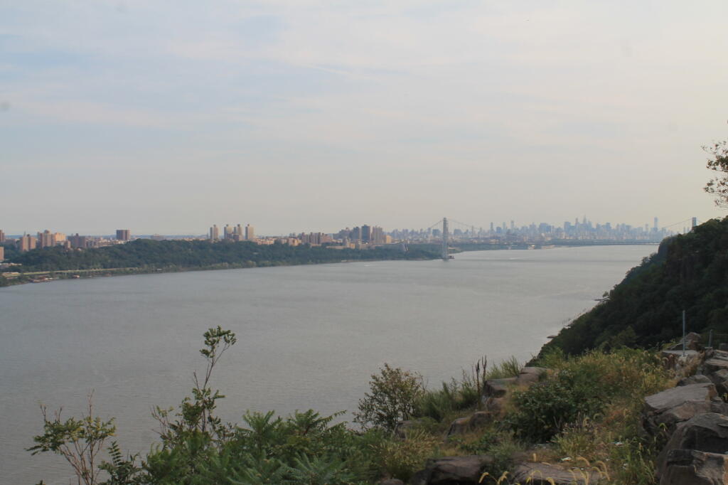
Palisades
One of the challenges is to find places where the Long Path leaves the public roads. Using OpenStreetMap data I created a line intersection of the Long Path against public roads, then with some hand editing made sure only to include off-road trail sections when they meet public roads. Then I ran it against the state’s reverse geocoding service to add street addresses so you can use it with your phone or car GPS.
| Street | City | ZIP | lat | lng |
| 2824 Touareuna Rd | Amsterdam | 12010 | 42.9305966 | -74.0868265 |
| 3699 W Glenville Rd | Amsterdam | 12010 | 42.9197609 | -74.0783142 |
| 933 Hoffmans Hill Rd | Schenectady | 12302 | 42.9171703 | -74.069787 |
| 699 Wolf Hollow Rd | Schenectady | 12302 | 42.9041371 | -74.0744891 |
| 400 Mabie Ln | Schenectady | 12306 | 42.8584106 | -74.0317499 |
| 119 Old Crawford Rd | Schenectady | 12306 | 42.8536279 | -74.0250397 |
| 3001 Lower Gregg Rd | Schenectady | 12306 | 42.8465301 | -74.029289 |
| 4632 Mariaville Rd | Schenectady | 12306 | 42.8231332 | -74.0648912 |
| 294 Judith Ln | Delanson | 12053 | 42.8115677 | -74.1163012 |
| 1442 Lake Rd | Delanson | 12053 | 42.8094393 | -74.1284678 |
| 2535 Lake Rd | Delanson | 12053 | 42.8038552 | -74.1438824 |
| 845 Bozenkill Rd | Altamont | 12009 | 42.7228851 | -74.0888376 |
| 774 Bozenkill Rd | Altamont | 12009 | 42.7210610000358 | -74.0833765001164 |
| 215 Old Stage Rd | East Berne | 12059 | 42.6814314 | -74.0545106 |
| 5 Hailes Cave Rd | Voorheesville | 12186 | 42.6557304 | -74.019139 |
| 649 Thacher Park Rd | Voorheesville | 12186 | 42.6489495 | -74.0063475 |
| 150 Bush Dr | East Berne | 12059 | 42.6386064 | -74.0150703 |
| 263 Treadlemire Rd | Berne | 12023 | 42.6291408 | -74.2703397 |
| 292 Durfee Rd | Middleburgh | 12122 | 42.6273097 | -74.2884482 |
| 197 Treadlemire Rd | Berne | 12023 | 42.6236946 | -74.2741212 |
| 1050 Cotton Hill Rd | Berne | 12023 | 42.6212871 | -74.2488514 |
| 96 Saw Mill Rd | East Berne | 12059 | 42.612683 | -74.041551 |
| 121 Stage Rd | East Berne | 12059 | 42.604945 | -74.0423173 |
| 182 Stage Rd | East Berne | 12059 | 42.603515 | -74.046072 |
| 524 Helderberg Trl | East Berne | 12059 | 42.6032471 | -74.0485744 |
| 619 Joslyn School Rd | East Berne | 12059 | 42.59829 | -74.051772 |
| 1250 Canady Hill Rd | Middleburgh | 12122 | 42.5976577 | -74.2377904 |
| 171 M T Path | Middleburgh | 12122 | 42.5976285 | -74.3243928 |
| 792 Pleasant Valley Rd | Warnerville | 12187 | 42.5969852 | -74.4358042 |
| 164 Irish Hill Rd | East Berne | 12059 | 42.5967723 | -74.1111937 |
| 268 Lawton Hollow Rd | Berne | 12023 | 42.5954718 | -74.2318034 |
| 617 Cole Hill Rd | East Berne | 12059 | 42.59463 | -74.0951211 |
| 21 Irish Hill Rd | East Berne | 12059 | 42.5936846 | -74.1061466 |
| 106 Mullberry Ln | Middleburgh | 12122 | 42.5904363 | -74.3507145 |
| 3984 State Route 30 | Middleburgh | 12122 | 42.5889397 | -74.3616479 |
| 313 Willsie Rd | East Berne | 12059 | 42.5878654 | -74.1074344 |
| 620 Woodstock Rd | Westerlo | 12193 | 42.5864761 | -74.0667513 |
| 3671 State Route 30 | Middleburgh | 12122 | 42.5848137 | -74.3898311 |
| 304 Mallon Rd | Warnerville | 12187 | 42.5836864 | -74.4368558 |
| 765 Bradt Hollow Rd | Berne | 12023 | 42.5826143 | -74.20655 |
| 705 Patria Rd | Warnerville | 12187 | 42.5792491 | -74.4468548 |
| 824 Gifford Hollow Rd | Berne | 12023 | 42.5769462 | -74.1226055 |
| 467 High Point Rd | Middleburgh | 12122 | 42.5767564 | -74.2104551 |
| 797 Gifford Hollow Rd | Berne | 12023 | 42.5741187 | -74.1400203 |
| 761 Gifford Hollow Rd | Berne | 12023 | 42.5716012 | -74.1344628 |
| 74 Beaver Rd | Berne | 12023 | 42.5678925 | -74.1759941 |
| 467 High Point Rd | Middleburgh | 12122 | 42.5669749 | -74.2029449 |
| 131 Patria Rd | Warnerville | 12187 | 42.5651591 | -74.4613942 |
| 74 Beaver Rd | Berne | 12023 | 42.5648224 | -74.1827641 |
| 854 Sickle Hill Rd | Berne | 12023 | 42.5619996991664 | -74.1654766243059 |
| 484 Ravine Rd | Berne | 12023 | 42.5617094 | -74.1512759 |
| 1233 Sawyer Hollow Rd | Richmondville | 12149 | 42.5589555 | -74.4869896 |
| 766 Rossman Hill Rd | West Fulton | 12194 | 42.5510553 | -74.4913793 |
| 1458 Burnt Hill Rd | West Fulton | 12194 | 42.5374204 | -74.4819581 |
| 162 Huckleberry Kingdom Rd | West Fulton | 12194 | 42.5303225 | -74.4777372 |
| 739 Cole Hollow Rd | West Fulton | 12194 | 42.518244 | -74.4800406 |
| 116 Duck Pond Rd | West Fulton | 12194 | 42.5071693 | -74.4829103 |
| 1632 Westkill Rd | North Blenheim | 12131 | 42.4851592 | -74.4845538 |
| 1819 Westkill Rd | Summit | 12175 | 42.4779248 | -74.4619016 |
| 1942 Westkill Rd | North Blenheim | 12131 | 42.4722731 | -74.4551777 |
| 137 Creamery Rd | North Blenheim | 12131 | 42.4710068 | -74.4605158 |
| 1670 State Route 30 | North Blenheim | 12131 | 42.4665802 | -74.461879 |
| 1022 State Route 30 | Gilboa | 12076 | 42.4292935 | -74.4724883 |
| 382 Stryker Rd | Gilboa | 12076 | 42.4136072 | -74.4633121 |
| 214 Champlin Rd | Gilboa | 12076 | 42.3801688 | -74.3755645 |
| 1022 Cunningham Rd | Durham | 12422 | 42.375758 | -74.232817 |
| 6 Cunningham Rd | Windham | 12496 | 42.3751153999999 | -74.2326722 |
| 698 S Mountain Rd | Gilboa | 12076 | 42.3737269 | -74.3152619 |
| 937 Cunningham Rd | Durham | 12422 | 42.37314 | -74.223946 |
| 277 Bluebird Rd | Gilboa | 12076 | 42.3702253 | -74.2873087 |
| 283 Pangman Rd | Gilboa | 12076 | 42.369517 | -74.4174038 |
| 295 Bluebird Rd | Gilboa | 12076 | 42.3685677 | -74.2893322 |
| 124 Jennie Notch Rd | Hensonville | 12439 | 42.3289038 | -74.1881716 |
| 530 Old Rd | Hensonville | 12439 | 42.320343 | -74.187498 |
| 3 Cross Rd | Windham | 12496 | 42.3128558 | -74.1898532 |
| 3622 Route 23A | Palenville | 12463 | 42.1768042 | -74.036803 |
| 3664 Route 23A | Palenville | 12463 | 42.1766161 | -74.0374648 |
| 3667 Route 23A | Palenville | 12463 | 42.1764158 | -74.0369105 |
| 3525 Route 23A | Palenville | 12463 | 42.1761367 | -74.0305116 |
| 414 Malden Ave | Palenville | 12463 | 42.1751342 | -74.0314163 |
| 327 Malden Ave | Palenville | 12463 | 42.1740101 | -74.0280332 |
| 2504 Platte Clove Rd | Elka Park | 12427 | 42.1331569 | -74.0854672 |
| 2425 Platte Clove Rd | Elka Park | 12427 | 42.1331288 | -74.0826962 |
| 25 Lane St | Phoenicia | 12464 | 42.0789625 | -74.3192493 |
| 5636 Route 28 | Phoenicia | 12464 | 42.070796 | -74.302315 |
| 359 Peekamoose Rd | Grahamsville | 12740 | 41.91677185 | -74.4378855 |
| 415 Peekamoose Rd | Grahamsville | 12740 | 41.9149657 | -74.4291244 |
| 197 Trails End Rd | Kerhonkson | 12446 | 41.884025 | -74.36059 |
| 559 Upper Cherrytown Rd | Kerhonkson | 12446 | 41.864115 | -74.346321 |
| 1054 Berme Rd | Kerhonkson | 12446 | 41.753416 | -74.339492 |
| 5113 State Route 52 | Ellenville | 12428 | 41.6928347 | -74.3935542 |
| 327 S Gully Rd | Ellenville | 12428 | 41.6781297 | -74.3708664 |
| 440 S Gully Rd | Ellenville | 12428 | 41.6777944 | -74.371414 |
| 11 VFW Rd | Wurtsboro | 12790 | 41.5752303 | -74.4670939 |
| 762 South Rd | Wurtsboro | 12790 | 41.5341248 | -74.5139809 |
| 99 County Road 61 | Otisville | 10963 | 41.4982235 | -74.5530519 |
| 113 County Road 61 | Otisville | 10963 | 41.4967773 | -74.5531814 |
| 507 State Route 211 | Cuddebackville | 12729 | 41.4802135 | -74.555461 |
| 303 County Road 61 | Otisville | 10963 | 41.4760327 | -74.5536354 |
| 2005 Guymard Tpke | Otisville | 10963 | 41.4265857 | -74.5963229 |
| 1 Blue Flag Ln | Cuddebackville | 12729 | 41.426566 | -74.5965342 |
| 545 County Road 50 | New Hampton | 10958 | 41.4121656 | -74.3941192 |
| 38 Echo Lake Rd | New Hampton | 10958 | 41.4121500424313 | -74.3787396591536 |
| 114 Hartley Rd | Goshen | 10924 | 41.409093 | -74.371953 |
| 46 Six And One Half Station Rd | Goshen | 10924 | 41.4012238 | -74.3590345 |
| 316 W Main St | Goshen | 10924 | 41.3998401 | -74.3340928 |
| 84 Green St | Goshen | 10924 | 41.3993471 | -74.322592 |
| 76 South St | Goshen | 10924 | 41.3939593 | -74.3226989 |
| 1032 Mountain Rd | Port Jervis | 12771 | 41.3926953 | -74.5986846 |
| 225 Knoell Rd | Goshen | 10924 | 41.3798692 | -74.2964613 |
| 102 Chester Heights Dr | Chester | 10918 | 41.3640215500303 | -74.2718868300712 |
| 860 State Route 32 | Highland Mills | 10930 | 41.3633416 | -74.1052241 |
| 3 Greycourt Ave | Chester | 10918 | 41.3625334936556 | -74.2691966874193 |
| 65 Greycourt Ave | Chester | 10918 | 41.3618575 | -74.2549727 |
| 1 Laguardia Rd | Chester | 10918 | 41.3590216381678 | -74.2397433875007 |
| 379 Seven Springs Rd | Monroe | 10950 | 41.3560042 | -74.1735084 |
| 168 Seven Springs Mountain Rd | Monroe | 10950 | 41.355365 | -74.177706 |
| 1214 Craigville Rd | Chester | 10918 | 41.3508776 | -74.2157511 |
| 136 Seven Springs Rd | Monroe | 10950 | 41.3504509 | -74.1819116 |
| 520 State Route 208 | Monroe | 10950 | 41.350432 | -74.1922682 |
| 36 Museum Village Rd | Monroe | 10950 | 41.35042 | -74.196911 |
| 130 Museum Village Rd | Monroe | 10950 | 41.346777 | -74.198612 |
| 64 Park Ave | Highland Mills | 10930 | 41.344474 | -74.120789 |
| 903 Barnes Lake Rd | Highland Falls | 10928 | 41.3285733 | -74.0783374 |
| 277 Estrada Rd | Central Valley | 10917 | 41.3238472 | -74.1048499 |
| 8 Reynolds Rd | Highland Falls | 10928 | 41.3205133 | -74.0952524 |
| 81 Bailey Town Rd | Highland Falls | 10928 | 41.3162793 | -74.0535806 |
| 2216 Seven Lakes Dr | Southfields | 10975 | 41.2776354 | -74.0961941 |
| 1771 Seven Lakes Dr | Southfields | 10975 | 41.2356802 | -74.102332 |
| 105 Johnsontown Rd | Stony Point | 10980 | 41.2226273 | -74.09728 |
| 403 Call Hollow Rd | Stony Point | 10980 | 41.218184 | -74.0489332 |
| 9 Cheesecote Ln | Pomona | 10970 | 41.2102991 | -74.0442959 |
| 7 Lakeview Ct | Pomona | 10970 | 41.2091934 | -74.0429687 |
| 199 Central Hwy | Garnerville | 10923 | 41.1921162 | -74.004641 |
| 1675 Route 202 | Pomona | 10970 | 41.1859757 | -74.0389189 |
| 33 Old Route 202A | Pomona | 10970 | 41.1843645 | -74.0365253 |
| 330 Old Route 304 | New City | 10956 | 41.176861 | -73.9629335 |
| 65 Landmark Dr | Congers | 10920 | 41.1745467 | -73.9446311 |
| 86 Landing Rd | Valley Cottage | 10989 | 41.1437105 | -73.9124038 |
| 582 N Route 9W | Nyack | 10960 | 41.1145506 | -73.9268341 |
| 404 Christian Herald Rd | Valley Cottage | 10989 | 41.1089732 | -73.9348648 |
| 61 Mountainview Ave | Nyack | 10960 | 41.0978228 | -73.935651 |
| 57 Mountainview Ave | Nyack | 10960 | 41.0975246 | -73.9362947 |
| 20 Towt St | Nyack | 10960 | 41.0906748 | -73.9360351 |
| 986 Bradley Pkwy | Nyack | 10960 | 41.0861861 | -73.9337348 |
| 233 South Blvd | Nyack | 10960 | 41.0813344 | -73.9298696 |
| 8 N Tweed Blvd | Nyack | 10960 | 41.0764606826772 | -73.9297238414169 |
| 5 First Class Marsico Ct | Blauvelt | 10913 | 41.0662594566299 | -73.9421404629506 |
| 68 Clausland Mountain Rd | Blauvelt | 10913 | 41.0622485 | -73.939429 |
| 244 Tweed Blvd | Nyack | 10960 | 41.0464497 | -73.9247046 |
| 49 Castle Rd | Sparkill | 10976 | 41.0420154 | -73.9251767 |
| 50 Ash St | Piermont | 10968 | 41.0413878 | -73.9181724 |
| 34 Tate Ave | Piermont | 10968 | 41.0404488 | -73.917408 |
| 30 Castle Rd | Sparkill | 10976 | 41.0397679 | -73.9235619 |
| 13 Paradise Ave | Piermont | 10968 | 41.0374884 | -73.9158113 |
| 70 Woods Rd | Palisades | 10964 | 41.01677 | -73.908588 |
| 4 Prior Ct | Palisades | 10964 | 41.0085899 | -73.913632 |
| 34 Route 9W | Palisades | 10964 | 41.0006901 | -73.9113535 |
| 100 Lawrence Ln | Palisades | 10964 | 40.9914837 | -73.9064843 |
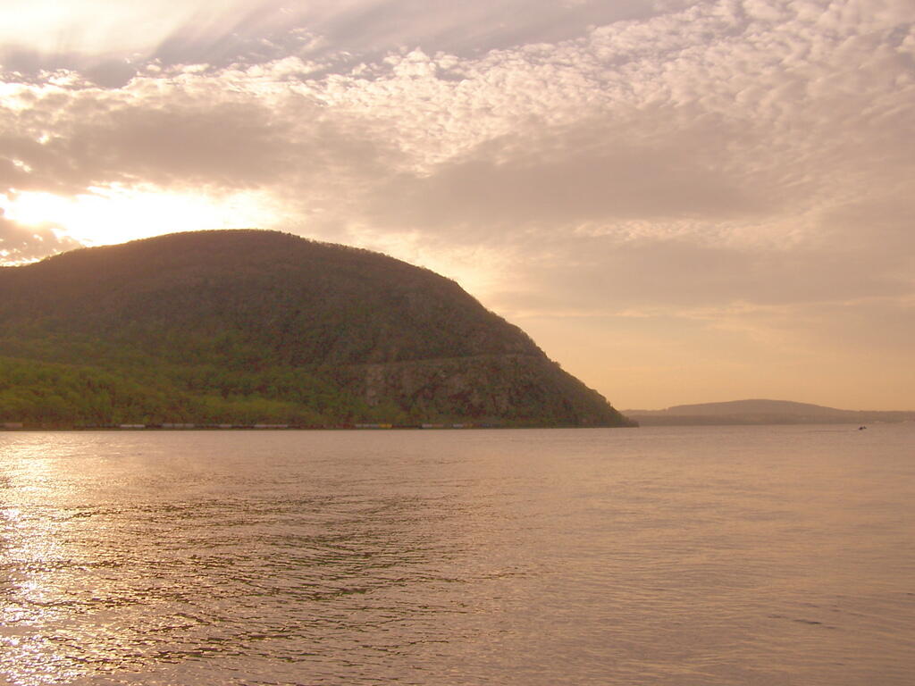
Just another beautiful spring evening in Palisades...
Taken on Tuesday April 22, 2008 at Little Stony Point.The 3,700-acre Split Rock Wild Forest is part of the Adirondack Forest Preserve. Located in the eastern foothills of the Adirondack Mountains along the shore of Lake Champlain, it comprises the largest tract of undeveloped Lake Champlain shoreline in New York.
The wild forest is named for Split Rock Mountain, the main feature of the area. The Lake Champlain Palisades and Webb Royce Swamp are within its boundaries. The trail system provides many scenic views of Lake Champlain and the Green Mountains of Vermont. The Westport Boat Launch Site, located in the Hammond Pond Wild Forest, is the nearest location to launch on the lake and access the shoreline campsites on Split Rock Wild Forest.