Search Results for: otter creek area
Empire Trail, Erie Canalway, Champlain Valley Trail Parking Areas
| Name | Address | Latitude | Longitude |
|---|---|---|---|
| Mohawk Hudson Bike Hike Trail (Albany to Peebles Island State Park) – 10.8 miles | |||
| Riverfront Garage | 2 Columbia St, Albany, NY 12207 | 42.65149 | -73.74890 |
| Corning Preserve Parking Area | Quay St, Albany, NY 12207 | 42.65346 | -73.74496 |
| Corning Preserve Boat Launch Parking | Water St, Albany, NY 12207 | 42.65612 | -73.74286 |
| Mohawk Hudson Bike Hike Trail | 330 Broadway, Watervliet, NY 12189 | 42.70950 | -73.70495 |
| Peebles Island State Park | 1 Delaware Ave North, Cohoes, NY 12047 | 42.78469 | -73.68042 |
| Waterford Parking Lot | Front St, Waterford, NY 12188 | 42.78592 | -73.67788 |
| Hudson Shores Park | 23rd Street, Watervliet, NY 12189 | 42.73216 | -73.69710 |
| Green Island Trail Parking | 260 Cannon St, Green Island, NY 12183 | 42.75824 | -73.68804 |
| Champlain Canalway Trail (Peebles Island State Park to Halfmoon) – 5.6 miles | |||
| Waterford Harbor Visitor Center | 1 Tugboat Alley, Waterford, NY 12188 | 42.78741 | -73.67902 |
| Park at the Point | 61 South St, Waterford, NY 12188 | 42.78823 | -73.68159 |
| Town of Halfmoon Trailhead Parking | Brookwood Rd, Waterford, NY 12188 | 42.83700 | -73.67586 |
| Town of Halfmoon Trailhead | Upper Newtown Rd, Mechanicville, NY 12118 | 42.86098 | -73.68230 |
| Lighthouse Park Halfmoon | 597 Hudson River Rd, Waterford, NY 12188 | 42.83821 | -73.67215 |
| CCT Parking | Schoolhouse Ln @ Bells Ln, Waterford, NY 12188 | 42.81920 | -73.67628 |
| On-Road Section (Halfmoon to Schuylerville) – 18.7 miles | |||
| Zim Smith East Trailhead | 1044 Elizabeth St Exd, Mechanicville, NY 12118 | 42.90909 | -73.70276 |
| Champlain Canalway Trail (Schuylerville to Fort Miller) – 6.7 miles | |||
| Old Schuylerville Junction Lock | County Rt 42, Schuylerville, NY 12871 | 43.11263 | -73.57849 |
| Hudson Crossing Park | Co Rd 42, Schuylerville, NY 12871 | 43.11456 | -73.57742 |
| Schuylerville Visitor Center | 30 Ferry St, Schuylerville, NY 12871 | 43.10001 | -73.57954 |
| Fort Hardy Park | Reds Rd, Schuylerville, NY 12871 | 43.10025 | -73.57857 |
| Champlain Canalway Trail (Fort Edward to Fort Ann) – 11.9 miles | |||
| Fort Edward Adult Exercise Park | 39 Mc Intyre St, Fort Edward, NY 12828 | 43.27362 | -73.57990 |
| Feeder Canal Trail Parking | Towpath Ln, Fort Edward, NY 12828 | 43.28390 | -73.56889 |
| Champlain Canalway Trail Parking | Baldwin Corners Rd, Fort Ann, NY 12827 | 43.39027 | -73.48666 |
| Champlain Canal Lock C-9 | 2450 NY-149, Fort Ann, NY 12827 | 43.35247 | -73.49676 |
| Champlain Canalway Trail | New Swamp Rd, Hudson Falls, NY 12839 | 43.33236 | -73.51177 |
| Feeder Canal Trail Parking | 2425 Burgoyne Ave, Hudson Falls, NY 12839 | 43.29780 | -73.56977 |
| Champlain Canalway Trail (Fort Ann to Comstock) – 5.1 miles | |||
| Fort Ann Canal Park | Ann St, Fort Ann, NY 12827 | 43.41416 | -73.48546 |
| Champlain On-Road Bicycle Route (Whitehall to Ticonderoga) – 25.5 miles | |||
| TR41-Whitehall NEW | Skenesborough Dr, Whitehall, NY 12887 | 43.55176 | -73.40285 |
| Champlain On-Road Bicycle Route (Ticonderoga to Westport) – 26.8 miles | |||
| Bicentennial Park | McCormick St, Ticonderoga, NY 12883 | 43.84908 | -73.42144 |
| Westport Trailhead | Main St (Route 9N), Westport, NY 12993 | 44.18174 | -73.43264 |
| Champlain On-Road Bicycle Route (Westport to Keeseville) – 30.8 miles | |||
| Keeseville Trailhead | Front St, Keeseville, NY12944 | 44.50545 | -73.48007 |
| Champlain On-Road Bicycle Route (Keeseville to Plattsburgh) – 14.1 miles | |||
| Terry Gordon Bike Path | Nevada Oval, Plattsburgh, NY 12901 | 44.67275 | -73.44310 |
| Champlain On-Road Bicycle Route (Plattsburgh to Rouses Point) – 25.8 miles | |||
| Plattsburgh Public Parking | Green St, Plattsburgh, NY 12901 | 44.69910 | -73.44864 |
| Terry Gordon Bike Path | Hamilton & Jay St, Plattsburgh, NY 12901 | 44.69380 | -73.44494 |
| Rouses Point Trailhead | 39 Lake St, Rouses Point, NY 12979 | 44.99658 | -73.36542 |
| Shoreline Trail – 8 miles | |||
| Fishing and Kayaking | South St, Buffalo, NY 14204 | 42.86554 | -78.86801 |
| Buffalo Harbor State Park Boat Launch | 1111 Fuhrmann Boulevard, Buffalo, NY 14203 | 42.84629 | -78.86315 |
| Tifft Nature Preserve | 1200 Fuhrmann Boulevard, Buffalo, NY 14203 | 42.84627 | -78.85944 |
| Buffalo Harbor State Park | 1111 Fuhrmann Boulevard, Buffalo, NY 14203 | 42.84517 | -78.86158 |
| Shoreline Trail (Buffalo) – 8 miles | |||
| Lasalle Park | DAR Drive, Buffalo, NY 14202 | 42.89368 | -78.89556 |
| Erie Canalway Trail (Tonawanda to Amherst) – 9.4 miles | |||
| Tonawanda EST Gateway | 72 E Niagara St, Tonawanda, NY 14150 | 43.02244 | -78.87073 |
| Shoreline Trail (Buffalo to Tonawanda) – 9.4 miles | |||
| Riverwalk Parking | 200 Niagara St, Tonawanda, NY 14150 | 43.01935 | -78.88756 |
| Niawanda Park | 200 Niagara St, Tonawanda, NY 14150 | 43.01781 | -78.88921 |
| Riverwalk Parking | 200 Niagara St, Tonawanda, NY 14150 | 43.01549 | -78.89387 |
| Niawanda Park | Shoreline Trail, Tonawanda, NY 14150 | 43.01300 | -78.90021 |
| Niawanda Park | 600 Niagara St, Tonawanda, NY 14150 | 43.01111 | -78.90557 |
| Niawanda Park | 600 Niagara St, Tonawanda, NY 14150 | 43.00952 | -78.91018 |
| Niawanda Park | 600 Niagara St, Tonawanda, NY 14150 | 43.00837 | -78.91334 |
| Niawanda Park | 600 Niagara St, Tonawanda, NY 14150 | 43.00715 | -78.91629 |
| Isle View County Park | 796 Niagara St, Tonawanda, NY 14150 | 43.00175 | -78.92581 |
| Aqua Lane Park | 128 Aqua Ln, Tonawanda, NY 14150 | 42.96398 | -78.92198 |
| Black Rock Harbor Road | Fort Ontario, Buffalo, NY 14207 | 42.94669 | -78.90924 |
| Black Rock Canal Park | Aqua Ln, Buffalo, NY 14207 | 42.94531 | -78.90952 |
| Ontario Boat Launch Dog Park | Fort Ontario, Buffalo, NY 14207 | 42.94442 | -78.90943 |
| Shoreline Trail – 9.4 miles | |||
| Towpath Park | Hertel Ave, Buffalo, NY 14207 | 42.93993 | -78.90773 |
| Erie Canalway Trail (Tonawanda to Amherst) – 10 miles | |||
| Buffalo Niagara Heritage Village | 3755 Tonawanda Creek Rd, Amherst, NY 14228 | 43.08452 | -78.72916 |
| Nature View Park Entrance | 1087 Tonawanda Creek Rd, Buffalo, NY 14228 | 43.06125 | -78.80003 |
| Creekside Drive Picnic Area | Creekside Dr, Tonawanda, NY 14150 | 43.02968 | -78.82829 |
| Creekside Drive Picnic Area | Creekside Dr, Tonawanda, NY 14150 | 43.02484 | -78.83238 |
| Amherst Veterans Canal Park | Tonawanda Creek Rd, Amherst, NY 14228 | 43.06492 | -78.80158 |
| Erie Canalway Trail (Amherst to Lockport) – 7.2 miles | |||
| Lockport Canal Bike Trail | 151-217 State Rd, Lockport, NY 14094 | 43.16407 | -78.70088 |
| East Canal Road Parking | E Canal Rd, Lockport, NY 14094 | 43.13259 | -78.72467 |
| Erie Canalway Trail Parking | 5557-5599 Feigle Rd, Lockport, NY 14094 | 43.11317 | -78.73737 |
| Erie Canalway Trail (Lockport to Middleport) – 12 miles | |||
| Erie Canalway Trail | Day Rd & N Canal Rd, Lockport, NY 14094 | 43.19173 | -78.64967 |
| Erie Canalway Trail Parking | 7839 LA-57, Lockport, NY 14094 | 43.18668 | -78.66616 |
| Erie Canalway Trail Parking | Peet St, Middleport, NY 14105 | 43.21479 | -78.50538 |
| Erie Canalway Trail Parking | Hartland Rd, Gasport, NY 14067 | 43.19985 | -78.57615 |
| Lockport Gateway Parking | Canal St, Lockport, NY 14094 | 43.17069 | -78.69381 |
| Erie Canalway Trail (Middleport to Albion) – 18.8 miles | |||
| Erie Canalway Trail Parking | Bates Rd, Medina, NY 14103 | 43.23052 | -78.37135 |
| Erie Canalway Trail Parking | Horan Rd, Medina, NY 14103 | 43.22577 | -78.38031 |
| Erie Canalway Trail Parking | North Gravel Rd, Medina, NY 14103 | 43.22573 | -78.39221 |
| Middleport Trailhead | Front St, Middleport, NY 14105 | 43.21348 | -78.47537 |
| Erie Canalway Trail Parking | N Main St, Albion, NY 14411 | 43.24927 | -78.19254 |
| Erie Canalway Trail (Albion to Brockport) – 11.4 miles | |||
| Sans Souci Canal Park | 4159 County Line Rd, Brockport, NY 14420 | 43.22226 | -77.99676 |
| Erie Canalway Trail Parking | 1 Holley Falls Park Rd, Holley, NY 14470 | 43.22795 | -78.02189 |
| Erie Canalway Trail Parking | Densmore Rd, Albion, NY 14411 | 43.25000 | -78.13532 |
| Brockport Trailhead | Redman Rd (Rt 31), Brockport, NY 14420 | 43.21436 | -77.96716 |
| Erie Canalway Trail Parking | N Main St, Brockport, NY 14420 | 43.21703 | -77.93834 |
| Erie Canalway Trail (Brockport to Rochester) – 19.2 miles | |||
| Erie Canalway Trail | N Union St (Rt 259), Spencerport, NY 14559 | 43.19388 | -77.80052 |
| Erie Canalway Trail Access | Lee Rd, Rochester, NY 14606 | 43.17123 | -77.68022 |
| Greece Canal Park | 343 Elmgrove Rd, Rochester, NY 14626 | 43.19127 | -77.73625 |
| Greece Canal Park | 343 Elmgrove Rd, Rochester, NY 14626 | 43.19877 | -77.73751 |
| Henpeck Park | 2901 Ridgeway Ave, Rochester, NY 14626 | 43.18833 | -77.73134 |
| Genesee Valley Park | 149 Elmwood Ave, Rochester, NY 14611 | 43.12358 | -77.64017 |
| Erie Canalway Trail (Rochester to Fairport) – 14.7 miles | |||
| Erie Canalway Trail Parking | Marsh Rd, Pittsford, NY 14534 | 43.07433 | -77.49283 |
| Great Embankment Park | Marsh Rd, Pittsford, NY 14534 | 43.07355 | -77.49023 |
| Lock 32 Canal Park | 2759 Clover St, Pittsford, NY 14534 | 43.09300 | -77.54798 |
| Meridian Centre Park | 2025 Meridian Centre Blvd, Rochester, NY 14618 | 43.10523 | -77.59538 |
| Erie Canalway Trail Parking | S Clinton St, Rochester, NY 14618 | 43.10621 | -77.59950 |
| Erie Canalway Trail Parking | 3 Schoen Pl, Pittsford, NY 14534 | 43.09200 | -77.51250 |
| Genesee Valley Park | Hawthorne Dr, Rochester, NY 14620 | 43.11628 | -77.63802 |
| Lock 33 Canal Park Trailhead | 1159-1175 Edgewood Ave, Rochester, NY 14618 | 43.09616 | -77.56898 |
| Perinton Community Park | 99 O’Connor Rd, Fairport, NY 14450 | 43.10078 | -77.45640 |
| Genesee Valley Park Gateway | Moore Rd, Rochester, NY 14620 | 43.11977 | -77.63706 |
| Erie Canalway Trail (Fairport to Palmyra) – 10.2 miles | |||
| Erie Canalway Trail Parking | Wayneport Rd, Macedon, NY 14502 | 43.07609 | -77.36101 |
| Erie Canalway Trail Parking | Cobb’s Ln, Fairport, NY 14450 | 43.09620 | -77.43081 |
| Macedon Bridge Parking | O’Neil Rd, Macedon, NY 14502 | 43.07035 | -77.28931 |
| Erie Canalway Trail (Palmyra to Newark) – 10.2 miles | |||
| Pal-Mac Park | 555 W Main St, Palmyra, NY 14522 | 43.06407 | -77.24792 |
| Erie Canalway Trail (Palmyra to Newark) – 9.6 miles | |||
| Harder Canal Park | West Shore Rd, Newark, NY 14513 | 43.05272 | -77.12667 |
| On-Street Parking | Van Buren St, Newark, NY 14513 | 43.04786 | -77.09380 |
| Swift Landing County Park | Hogback Hill Rd, Palmyra, NY 14522 | 43.06683 | -77.18848 |
| Palmyra Marina | Division St, Palmyra, NY 14522 | 43.06573 | -77.22933 |
| Erie Canalway Trail (Newark to Savannah) – 20.4 miles | |||
| Galen Boat Launch | Water St, Clyde, NY 14433 | 43.08016 | -76.87079 |
| Abbey Park Trailhead | 177 Water St, Lyons, NY 14489 | 43.06384 | -77.00222 |
| Erie Canalway Trail Parking | Old Lyons Rd, Newark, NY 14513 | 43.06357 | -77.02061 |
| Lock 28B Canal Park | 106 N Clinton St, Newark, NY 14513 | 43.04724 | -77.08449 |
| Empire State Bicycle Route (Savannah to Port Byron) – 10.2 miles | |||
| Old Erie Canal Heritage Park | 1575 Rooker Dr, Port Byron, NY 13140 | 43.03579 | -76.63501 |
| Erie Canalway Trail (Port Byron to Camillus) – 20.2 miles | |||
| Nancy Brown Wildlife Sanctuary | Warners Rd, Camillus, NY 13031 | 43.06302 | -76.26889 |
| Lock 51 Parking | Route 31, Jordan, NY 13080 | 43.06668 | -76.49592 |
| Erie Canalway Trail Parking | Route 31 (Erie Dr), Weedsport, NY 13166 | 43.04336 | -76.57577 |
| Nine Mile Creek Aqueduct | Thompson Rd, Camillus, NY 13031 | 43.05869 | -76.28733 |
| Erie Canal Park | 5750 Devoe Rd, Camillus, NY 13031 | 43.05262 | -76.30320 |
| Warners Park | Newport Rd, Warners, NY 13164 | 43.07605 | -76.32720 |
| Schasel Park Trailhead | 20-28 Utica St, Port Byron, NY 13140 | 43.03748 | -76.61930 |
| Empire State Trail (Camillus to Syracuse) – 9.2 miles | |||
| Inner Harbor Creekwalk | W Kirkpatrick St, Syracuse, NY 13204 | 43.05922 | -76.16602 |
| Gere Lock Parking | Horan Rd, Syracuse, NY 13209 | 43.06878 | -76.23436 |
| Loop the Lake Trail | 280 Restoration Way, Syracuse, NY 13209 | 43.06680 | -76.19696 |
| Creekwalk Parking | Bear St W, Syracuse, NY 13204 | 43.06129 | -76.16960 |
| State Fairgrounds Trailhead | Gate 2 State Fair Blvd, Syracuse, NY 13209 | 43.07324 | -76.21563 |
| Reed Webster Park | Warners Rd, Camillus, NY 13031 | 43.06405 | -76.26878 |
| Erie Canalway Trail (DeWitt to Chittenango) – 10.6 miles | |||
| Cedar Bay Park | Lyndon Rd, Fayetteville, NY 13066 | 43.04328 | -76.03750 |
| Old Erie Canal State Park – Minoa | Green Lakes Rd, Fayetteville, NY 13066 | 43.05389 | -76.00029 |
| Old Erie Canal State Park | N Burdick St, East Syracuse, NY 13057 | 43.04350 | -76.02227 |
| Old Erie Canal State Park | Kirkville Rd N, Kirkville, NY 13082 | 43.07030 | -75.94932 |
| Old Erie Canal State Park – Poolsbrook | Andrus Rd, Kirkville, NY 13082 | 43.07335 | -75.92142 |
| DeWitt – Old Erie Canal State Park | Butternut Dr, East Syracuse, NY 13057 | 43.04440 | -76.05074 |
| Erie Canalway Trail (Chittenango to Erie Canal Lock 21) – 19.6 miles | |||
| Old Erie Canal State Park | Beebe Bridge Rd, Canastota, NY 13032 | 43.07399 | -75.78531 |
| Old Erie Canal State Park | N Court St, Canastota, NY 13032 | 43.08891 | -75.71069 |
| Old Erie Canal State Park – Chittenango | Lakeport Rd, Chittenango, NY 13037 | 43.06041 | -75.87072 |
| Erie Canalway Trail (Erie Canal Lock 21 to Rome) – 9.3 miles | |||
| Empire State Heritage Park | NY-46, Rome, NY 13440 | 43.22640 | -75.50188 |
| Erie Canalway Trail (Rome to Utica) – 16.5 miles | |||
| Erie Canalway Trail | Mohawk St, Marcy, NY 13403 | 43.13433 | -75.27838 |
| Lock 20 Trailhead | 5842 NY-291, Marcy, NY 13403 | 43.14433 | -75.29771 |
| Oriskany Flats Wildlife Management Area | Oriskany Rd (Rt 32), Oriskany, NY 13424 | 43.16634 | -75.32525 |
| Erie Canalway Trail Parking | NY-69, Oriskany, NY 13424 | 43.16014 | -75.33278 |
| Erie Canalway Trail Parking | Rome Oriskany Road, Rome, NY 13440 | 43.19383 | -75.43258 |
| Bellmay Harbor Park | 139 E Whitesboro St #111, Rome, NY 13440 | 43.20229 | -75.44865 |
| Erie Canalway Trial Parking | E Whitesboro St, Rome, NY 13440 | 43.20200 | -75.45406 |
| Gyziec Field Parking | S James St & Muck Rd, Rome, NY 13440 | 43.20253 | -75.46768 |
| NYSCC-Utica | 39-99 Harbor Lock Rd E, Utica, NY 13502 | 43.11242 | -75.21740 |
| Erie Canalway Trail (Frankfort to Little Falls) – 10.8 miles | |||
| Mohawk Boat Launch | 102 E Main St, Mohawk, NY 13407 | 43.01485 | -74.99466 |
| Ilion Marina | 190 Central Ave, Ilion, NY 13357 | 43.02058 | -75.03039 |
| German Flatts Town Park | 575 NY-5S, Mohawk, NY 13407 | 43.01797 | -74.95521 |
| Erie Canalway Trail Parking | W Shore St, Little Falls, NY 13365 | 43.03757 | -74.86073 |
| Erie Canal Lock E-18 | State Route 5S, Mohawk, NY 13407 | 43.01600 | -74.91772 |
| Erie Canalway Trail (Little Falls to Canajoharie) – 18.7 miles | |||
| Erie Canalway Trail Parking | Bridge St @ S Saint Johnsville Rd, Fort Plain, NY 13339 | 42.99223 | -74.68075 |
| Canajoharie Trailhead | Old Fort Plain Rd, Canajoharie, NY 13317 | 42.90505 | -74.58544 |
| Herkimer Home SHS | 200 NY-169, Little Falls, NY 13365 | 43.02756 | -74.81748 |
| Erie Canalway Trail (Canajoharie to Amsterdam) – 22.9 miles | |||
| Canalway Bike Parking Lot | Bridge St, Amsterdam, NY 12010 | 42.93480 | -74.19961 |
| Auriesville Pilgrimage Lunch Area | Queen Anne Road, Amsterdam, NY 12010 | 42.95260 | -74.23838 |
| Schoharie Crossing State Historic Site | 129 Schoharie St, Fort Hunter, NY 12069 | 42.93994 | -74.28280 |
| Erie Canalway Trail (Amsterdam to Schenectady) – 16.9 miles | |||
| Erie Canalway Trail Parking | Rice Rd, Schenectady, NY 12306 | 42.81765 | -73.98462 |
| Lock 8 Park | 106 Rice Rd, Schenectady, NY 12306 | 42.82872 | -73.99157 |
| Rotterdam Kiwanis Park | Route 5S, Rotterdam, NY 12306 | 42.84652 | -74.01414 |
| Erie Canalway Trail Parking | Route 5S (River Rd), Pattersonville, NY 12137 | 42.89111 | -74.08159 |
| Mohawk River Gateway | 1 Bridge St, Amsterdam, NY 12010 | 42.93520 | -74.19560 |
| Erie Canalway Trail (Schenectady to Niskayuna) – 10.9 miles | |||
| Lions Park | 3439 Rosendale Rd, Niskayuna, NY 12309 | 42.77743 | -73.82407 |
| Lock 7 Park | Lock 7 Rd, Schenectady, NY 12309 | 42.80253 | -73.84749 |
| Jeff Blatnick Park | River Rd, Schenectady, NY 12309 | 42.81600 | -73.86341 |
| Erie Canalway Trail (Niskayuna to Green Island) – 10.5 miles | |||
| MHBHT Parking | 27 Alexander St, Cohoes, NY 12047 | 42.76083 | -73.70414 |
| Erie Canalway Trail (Niskayuna to Cohoes) – 10.5 miles | |||
| MHBHT Parking | Loudon Rd, Cohoes, NY 12047 | 42.79801 | -73.73423 |
| Colonie Mohawk River Park | 71 Schermerhorn Rd, Cohoes, NY 12047 | 42.79498 | -73.74503 |
| Mohawk Riverside Landing Park | 4071 River Rd, Schenectady, NY 12309 | 42.77184 | -73.81475 |
| Manhattan Greenway Trail (The Battery to Inwood Hill) – 13 miles | |||
| Riverside Park (limited parking) | Henry Hudson Pkway Northbound @ W 96th St, Manhattan, NY 10025 | 40.79789 | -73.97613 |
| NYC On-Road Section (Inwood Hill to Van Cortlandt Park) – 3 miles | |||
| Manhattan Greenway Trail On-Street Parking | 348 Dyckman St, New York, NY 10034 | 40.86824 | -73.93033 |
| Bronx and Westchester South County Trail (Van Cortlandt Park to Elmsford) – 13.6 miles | |||
| HF Redmond Park | Redmond Park, Yonkers, NY 10701 | 40.93827 | -73.86921 |
| South County Trail Parking | 132 Tuckahoe Rd, Yonkers, NY 10701 | 40.95519 | -73.86624 |
| South County Trail Parking | Farragut Ave, Hastings-On-Hudson, NY 10706 | 40.98298 | -73.86601 |
| Great Hunger Memorial (VE Macy Park) | Saw Mill River Parkway, Elmsford, NY 10523 | 41.02507 | -73.84579 |
| Tibbets Brook Park | 355 Midland Ave, Yonkers, NY 10704 | 40.92976 | -73.87722 |
| Van Cortlandt Park | Van Cortlandt Park S, The Bronx, NY 10463 | 40.88900 | -73.89336 |
| Tibbets Brook Park | 355 Midland Ave, Yonkers, NY 10704 | 40.93049 | -73.87427 |
| South County Trail Parking | Grey Oaks Ave, Yonkers, NY 10710 | 40.97597 | -73.86766 |
| On-Street Parking | Broadway @ W 242nd St, Bronx, NY 10471 | 40.88919 | -73.89824 |
| Westchester North County Trail (Elmsford to New Castle) – 9.8 miles | |||
| South County Trail Parking | Old Saw Mill River Rd (Route 303), Elmsford, NY 10523 | 41.08039 | -73.82943 |
| Tarrytown Lakes Park | 209 Neperan Rd, Tarrytown, NY 10591 | 41.07811 | -73.84834 |
| Park and Ride Lot | Old Saw Mill River Rd (Route 303), Elmsford, NY 10523 | 41.08239 | -73.83067 |
| North County Trail Parking | Bedford Rd (Route 117), Pleasantville, NY 10570 | 41.12339 | -73.81113 |
| Walter Law Memorial Park | Library Rd, Briarcliff Manor, NY 10510 | 41.14573 | -73.82451 |
| North County Trail Parking | Route 100/N State Rd, Ossining, NY 10562 | 41.17522 | -73.81163 |
| Westchester Landing (Gov. Mario M. Cuomo Bridge) | 333 S Broadway, Tarrytown, NY 10591 | 41.06540 | -73.86343 |
| Rockland Landing (Gov. Mario M. Cuomo Bridge) | 267 S Broadway, Nyack, NY 10960 | 41.08169 | -73.92205 |
| Westchester North County Trail & Putnam Trailway (New Castle to Mahopac) – 16.1 miles | |||
| Mahopac Park and Ride | Bucks Hollow Rd, Mohopac, NY 10541 | 41.37285 | -73.73082 |
| Putnam Trailway Parking | Mt Hope Rd, Mahopac, NY 10541 | 41.37291 | -73.72876 |
| North County Trail Parking | Station Rd (Route 133), Chappaqua, NY 10514 | 41.18680 | -73.80079 |
| Millwood Municipal Parking | Route 133/Station Rd, Chappaqua, NY 10514 | 41.18968 | -73.79717 |
| North County Trail Parking | Route 118 (Saw Mill River Rd), Yorktown Heights, NY 10598 | 41.23136 | -73.77910 |
| Yorktown Municipal Parking | Kear St, Yorktown Heights, NY 10598 | 41.27055 | -73.77999 |
| Yorktown Heights Parking | 363 Underhill Ave, Yorktown Heights, NY 10598 | 41.26911 | -73.78163 |
| Junior Lake Park | 1939 Edgewater St, Yorktown Heights, NY 10598 | 41.27637 | -73.77495 |
| North County Trail Parking | Route 118-Tomahawk St, Baldwin Place, NY 10505 | 41.34469 | -73.75518 |
| Bucks Hollow Rd Parking | Bucks Hollow Rd (Off Route 6), Mahopac, NY 10541 | 41.36744 | -73.73981 |
| Putnam Trailway (Mahopac to Brewster) – 8 miles | |||
| Putnam Trailway Parking | Mud Pond Rd, Mohapac, NY 10541 | 41.37876 | -73.72301 |
| Putnam Trailway Parking | Willow Rd, Carmel Hamlet, NY 10512 | 41.41461 | -73.68627 |
| Putnam Trailway Parking | 30 Tilly Foster Rd, Brewster, NY 10509 | 41.41327 | -73.63908 |
| Carmel Hamlet Parking | 1808 US-6 (Stoneleigh Ave), Carmel Hamlet, NY 10512 | 41.41868 | -73.67240 |
| Maybrook Trailway (Brewster to Pawling) – 9.3 miles | |||
| Maybrook Trailway Parking – Lake Tonetta | 146 Pumphouse Rd, Brewster, NY 10509 | 41.41778 | -73.61374 |
| Maybrook Trailway (Pawling to Hopewell Junction) – 14.8 miles | |||
| Maybrook Trailway Parking | South Green Haven Rd, Poughquag, NY 12570 | 41.57587 | -73.70843 |
| Maybrook Trailway Parking | 237 NY-292, Pawling, NY 12531 | 41.52423 | -73.64727 |
| Dutchess Rail Trail (Hopewell Junction to Poughkeepsie) – 13.6 miles | |||
| Dutchess Rail Trail Parking | Diddell Rd, Wappingers Falls, NY 12590 | 41.62286 | -73.85113 |
| Dutchess Rail Trail Parking | Van Wyck Lane, Wappingers Falls, NY 12590 | 41.60340 | -73.83655 |
| Dutchess Rail Trail Parking | Railroad Ave, Hopewell Junction, NY 12533 | 41.58550 | -73.80697 |
| Victor Waryas Park | 75 N Water St, Poughkeepsie, NY 12601 | 41.70748 | -73.94009 |
| Waryas Park | 75 N Water St, Poughkeepsie, NY 12601 | 41.70700 | -73.93943 |
| Morgan Lake Park | 51 Creek Rd, Poughkeepsie, NY 12601 | 41.71728 | -73.90699 |
| Overocker Rd Parking Area | Overocker Rd, Arlington, NY 12603 | 41.69363 | -73.88423 |
| Old Manchester Rd Trail Parking | Old Manchester Rd, Poughkeepsie, NY 12603 | 41.68336 | -73.86533 |
| LaGrange Trail Parking | Old Machester Rd, Poughkeepsie, NY 12603 | 41.68297 | -73.86347 |
| Dutchess Rail Trail Parking | 258 Titusville Rd, Poughkeepsie, NY 12603 | 41.65609 | -73.85640 |
| Dutchess Rail Trail Parking | Lake Walton Rd, Hopewell Junction, NY 12533 | 41.60174 | -73.83602 |
| Walkway Over the Hudson | 61 Parker Ave, Poughkeepsie, NY 12601 | 41.71244 | -73.92491 |
| Love Rd Parking Area | 35-99 Love Rd, Arlington, NY 12603 | 41.69878 | -73.88619 |
| Hudson Valley Rail Trail (Lloyd to New Paltz) – 10.5 miles | |||
| Hudson Valley Rail Trail | Haviland Rd Lot, Highland, NY 12528 | 41.71032 | -73.95717 |
| Hudson Valley Rail Trail | Commercial Ave, Highland, NY 12528 | 41.71906 | -73.96886 |
| Hudson Valley Rail Trail | New Paltz Rd, Highland, NY 12528 | 41.73418 | -73.97483 |
| Tony Williams Park | S Riverside Rd, Highland, NY 12528 | 41.73595 | -74.00204 |
| HRVT South St Parking | 565-557 NY-299, Highland, NY 12528 | 41.73749 | -74.03449 |
| Walkway Over the Hudson | 87 Haviland Rd, Highland, NY 12528 | 41.71027 | -73.95510 |
| Sojourner Truth Park | 55 Plains Rd, New Paltz, NY 12561 | 41.74322 | -74.09299 |
| Wallkill Valley Rail Trail (New Paltz to South Kingston) – 13.2 miles | |||
| DEC Wallkill Boat Launch | 395 Springtown Rd, New Paltz, NY 12561 | 41.80199 | -74.08566 |
| WVRT Binnewater Parking | 720 Binnewater Rd, Rosendale, NY 12472 | 41.84813 | -74.08809 |
| Ulster County Municipal Parking | North Chestnut St, New Paltz, NY 12561 | 41.75464 | -74.08436 |
| Wallkill Valley Rail Trail | Rt 32 and Rockwell Ln, Kingston, NY 12401 | 41.91026 | -74.02140 |
| WVRT Parking | Coffey Rd, New Paltz, NY 12561 | 41.78143 | -74.09244 |
| Municipal Parking Lot | Huguenot St, New Paltz, NY 12561 | 41.75075 | -74.08973 |
| Kingston Section (South Kingston – East Kingston) – 6.7 miles | |||
| City of Kingston Public Parking | Dock St, Kingston, NY 12401 | 41.91696 | -73.98465 |
| West Strand Park Parking | E Strand St, Kingston, NY 12401 | 41.91834 | -73.98221 |
| Rondout Landing Street Parking | Rondout Lndg, Kingston, NY 12401 | 41.91917 | -73.98089 |
| Kingston Pt Rail Trail Parking | East Chestnut St, Kingston, NY 12401 | 41.92687 | -73.99380 |
| Kingston Point Beach | Delaware Ave Parking Lot, Kingston, NY 12401 | 41.92991 | -73.96511 |
| Hudson Valley On-Road Section (East Kingston to Tivoli) – 11.9 miles | |||
| Poets Walk Park | 776 River Rd, Red Hook, NY 12571 | 41.98197 | -73.91851 |
| Tivoli Community Lot | Broadway, Tivoli, NY 12583 | 42.05881 | -73.91215 |
| Tivoli Bays Wildlife Management Area | Off Kidd Lane, Tivoli, NY 12583 | 42.03886 | -73.91442 |
| Hudson Brickyard Trail | John St, Kingston, NY 12401 | 41.95186 | -73.96395 |
| Tivoli Bays Wildlife Management Area | Kidd Lane, Tivoli, NY 12583 | 42.04595 | -73.90676 |
| Kingston-Rhinecliff Bridge Toll Plaza | State Route 199 (NY-199), Kingston, NY 12402 | 41.98025 | -73.96296 |
| Kingston-Rhinecliff Bridge East Approach Parking | State Route 199 (NY-199), Kingston, NY 12402 | 41.97267 | -73.92535 |
| Hudson Valley On-Road Section (Tivoli to Olana) – 16.1 miles | |||
| Clermont State Historic Site | 1 Clermont Ave, Germantown, NY 12526 | 42.08409 | -73.91881 |
| Germantown Municipal Parking | 189 Main St, Germantown, NY 12526 | 42.13217 | -73.88266 |
| Hudson Valley On-Road Section (Olana to Hudson) – 6.7 miles | |||
| Hudson Trailhead | N 2nd St & Dock St, Hudson, NY 12534 | 42.25761 | -73.78941 |
| Hudson Skywalk Trailhead | Routes 9G and 23, Hudson, NY 12534 | 42.21932 | -73.83254 |
| Albany-Hudson Electric Trail (Hudson to Kinderhook) – 10.5 miles | |||
| Stottville Park Trailhead | Atlantic Ave, Stottville, NY 12172 | 42.28591 | -73.73847 |
| Stuyvesant Falls Trailhead | CR 25A (Hudson Ave), Stuyvesant, NY 12174 | 42.35813 | -73.73331 |
| Stuyvesant Falls Park | Lindenwald Ave, Stuyvesant, NY 12174 | 42.35723 | -73.73241 |
| Albany-Hudson Electric Trail (Kinderhook to Nassau) – 11.1 miles | |||
| Kinderhook Village Playground Park | Rothermel Ave, Kinderhook, NY 12106 | 42.39639 | -73.70419 |
| Kinderhook / Valatie Trailhead | Routes 9 & 9H, Valatie, NY 12184 | 42.40878 | -73.69047 |
| Niverville Trailhead | Rt 203 and Main St (CR 28), Niverville, NY 12130 | 42.43335 | -73.65889 |
| Albany-Hudson Electric Trail (Nassau to East Greenbush) – 10.5 miles | |||
| Village of Nassau Trailhead | John Street, Nassau, NY 12123 | 42.51454 | -73.61221 |
| Nassau Lake Trailhead | County Route 7, Nassau, NY 12123 | 42.53585 | -73.60887 |
| North Chatham Trailhead | Depot Street, North Chatham, NY 12132 | 42.47592 | -73.63326 |
| On-Road Section (East Greenbush to Albany) – 3.5 miles | |||
| Riverfront Park Trailhead | Broadway, Rensselaer, NY 12144 | 42.64291 | -73.74536 |
| Clinton Street Trailhead | Clinton St. and Columbia Turnpike (Rt 20), East Greenbush, NY 12061 | 42.61908 | -73.73343 |
| East Greenbush Trailhead | Southern Avenue (at the intersection with Hudson Ave West), Rensselaer, NY 12144 | 42.61742 | -73.73073 |
Camping Areas in Central Adirondacks ⛺
Cascade Lake – Scenic lake known for Cascade Falls, about a 1/4 mile north of the lake outside of Big Moose and Inlet. Tent campsites that are about a mile back from the road.
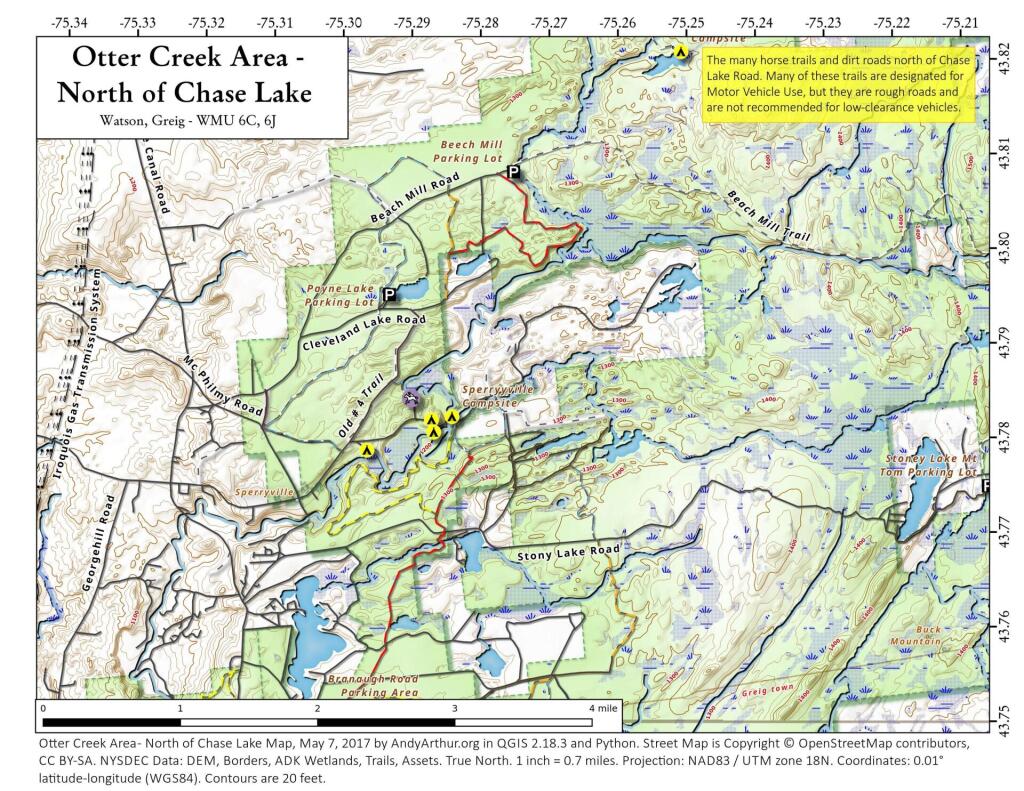
Eatonville Road and Otter Creek Area – Otter Creek State Forest and the portion of Independence River Wild Forest that is home to Confusion Flats, is a popular place for equestrians, but the Eatonville Road area is set aside for those who don’t have horses but want to explore the mix of sandy hills that make up the Western Adirondacks.
Francis Lake – If your looking for a campsite you can paddle to on a lake that isn’t so choppy or large near Stillwater Reservoir, consider camping at Francis Lake. Parking is on the shoulder of Number 4 Road outside of Lowville, there also is two designated handicap sites here.
Lester Flow and Cheney Pond – Scenic lake that is popular for paddling. The 1/2 mile road down from Boreas Road as of June 2020 is closed due to washouts. Tent sites exist along the lake, along with one drive-to site on the road down there. No cell service.
Independence River Wild Forest – Not only is there dozens of boat-only sites along Stillwater Reservoir, consider camping on Smith Road or Basket Factory Road which have numerous sites. Cell services is limited, good at certain sites, especially Smith Road Number 1 (Old Firetower Site).
Mason Lake – Small lake located about 10 miles north of Speculator and 5 miles south of Lewey Lake that has several tent and drive-in campsites along it’s shore. Good to fair cell service here. Nice to hear loons, one of the best bass ponds in the area.
Moss Lake – Scenic sandy lake outside of Big Moose/Inlet in the Western Adirondacks. The lake is ringed by an old carriageway and is a popular place to camp and paddle. There is a sign in / peg board when you get to the lake’s parking area to know which sites are available.
Moose River Plains – The state’s largest wilderness drive-to camping area, with over 150 campsites spread out over 35 miles of dirt road.
Northwood Club Road – In Minerva, this road crosses the Boreas River and has several roadside campsites, and passes by Huntley Pond, the NL Tahawus Railroad (which can be hiked to the Boreas River at Hudson River), and the Blue Ledges on the Hudson trailhead. No cell service.
Vanderwhacker Road -Five or six campsites exist along Vanderwhacker Road, which can be muddy in the spring and icy in late autumn. Additional designates campsites exist near where NY 28N crosses the Vanderwhacker River. Near the trail to the Vanderwhacker Firetower, No cell service.
Woodhull Lake Reservoir – Off of NY 28 in McKeevers, about 10 miles south of Old Forge. Not only is this beautiful reservoir to paddle, there are some campsites along the shore, with drive-to campsites along Wolf Lake Landing Road which leads to it. Part of Wolf Lake Landing Road is erroded, but other parts are fresh stone-dust. It’s remote wilderness but there good cell service in mcuh of the area.
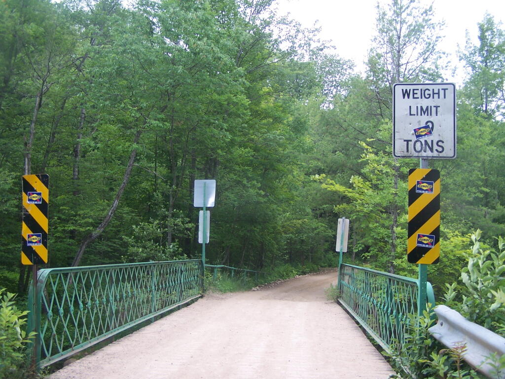
Otter Creek Bridge
Down at the Otter Creek Camping Area in Otter Creek State Forest.
Taken on Tuesday June 28, 2011 at Otter Creek.August 22, 2015 evening
Good evening. 65 degrees this evening and clear. Partly sunny tommorow and 82 as this nice strech of weather continues.
Still achy and sore from the sprained ankle. Not much has changed. Been really tired too. Maybe it’s because of the difficulty walking around and the constant lifting of my body by my arms and one leg. Maybe it’s Lyme Disease, I don’t know. Mom is always telling me I should get tested for Lyme. Spent most of the day in bed, first working on maps, then resting, then reading. I still dread the shower because I have to take the sprain boot off and regardless of what I do to not load the bad ankle, it still hurts like a mother at times.
Ended up going to Walmart to buy fishing hooks and ended up grocery shopping a because I was up and it’s getting in my jacked up truck that still hurts more than anything – especially if I’m not real careful to lift myself with my arms and the cruch both in and out. The grocery cart helped with walking in the store. By the time I got back to the truck, I felt I had walked 10 miles. Got the groceries I need for the week and gased up, so I can go out to Partridge Run tommorow to go fishing. Also went to Henry Hudson Park, for a drive but did not get out of my truck, as it was getting late, and it just is hard for me to get back in. Still pretty looking out at the river. Maybe go river fishing next week.
Sprained ankles sound stupid and common place, but they are a real nasty injury and don’t heal overnight. 23 more days in the sprain boot to heal then whatever time it takes to fully rebuild strength in the ankle before I can do a lot of hiking again. Probably start by walking down to the library, then the evening walk, which will get me up to 4.1 miles per day. Add in a mile walk a lunch and I’m over 5 miles per day. In some ways this is a wakeup call – I’m thinking of a diet and a more aggressive exercise plan beyond just walking 4-5 miles a day after my ankle recovers. Not sure what it will involve – probably drinking fewer of the Bud Heavies.
As September 16th I get to take the boot off, probably will take off September 17, 18, and the weekend off to travel. Right now I’m leaning towards going up to the Tug Hill and Otter Creek area but I’m not totally sure. I know I will still be limited somewhat for hiking but there is lots of fun stuff to do in the woods during the fall.
August 6, 2015 evening
65 degrees and high clouds kind of shading out the stars. Getting down to 56 tonight. Spring peepers and and crickets are singing but no fireflies to report on tonight. A pleasant evening.
Went down to the Park and started to read a new book I got out of the library called Gun Guys. Kind of a book written by an urban liberal who falls love with guns. It gets dark early, so I brought my laptop down there and played on it until 9:15 pm after too dark to read. It’s nice having WiFi at the park. Will come in handy on Saturday when the library closes a 5 pm.
This weekend staying in town. Probably Hudson River fishing on Friday night. Doing an oil change on Saturday and plan to figure out which of the electrical connections ain’t working in the fuse holder. Something ain’t right because the second battery ain’t charging. Also need to fix the truck cap support. Hopefully next weekend will head out of town if the weather is nice.
Took off August 20-23rd to head up to the Otter Creek area of the Western Adirondacks. Want to spend more time exploring some of the trails up there, the Whetstone Gulf and the Whetstone Reservoir. Should be a nice weekend. Next weekend maybe is Schoharie and swimming at Mine Kill State Park swimming pool.
Started researching jobs, apartments, land, and recreation in Scranton PA. I have been thinking on and off about moving to Pennsylvania where they have better gun laws, lower taxes, and a less anti-rural culture. PA allows open carry and concealed carry licenses is reasonable to obtain. No special permits for handguns besides the normal background check. They seem to leave homesteaders and farmers alone unlike NY were Humane Society is crawling up folks asses. Lots of backcountry land up that way if you don’t mind abandoned clum piles. Open burning within reason is allowed in most rural areas as long as it’s not too much a nuisance.
I have been evaluating Pennsylvania cities for some time, and while Harrisburg was at one time top of my list, Erie and Scranton have risen on my list as I would rather live in a smaller more rural area that is less political than Albany. In some ways Erie has better recreation opportunities as closer to Allegheny National Forest but Scranton is closer to where I live now for further evaluation and ease of move and jobs. Potter County and Coudersport would be cool but I think good jobs in small towns are even harder to find.
Land prices around Scranton are much cheaper, which makes owning land more practical. My goal is eventually live off grid or at least have enough land to shoot guns out back, have fires and burn things, and hobby farm. Scranton keeps the wild Western Catskills and Tioga County PA region fairly close plus the Delaware Water Gap. I don’t have a job yet and have only started my research. But looking at job postings. And I haven’t been to the city to see what it’s really like but I have been studying maps carefully. Probably not making the jump this year but might take a day trip or two and interview for a few jobs.
Preston Hollow
Preston-Potter Hollow is small hamlet south-western Albany County in the Town of Rensselaerville with a population of 366. Probably most famous for the trout fishing on the Catskill Creek, it's a pretty outlaying area in a deep hollow nested between the mountains, with lots of good ol' country boys living in the hills and hollows surrounding it.