Moose River Recreation Area 1980s
Before the road to Balsam Lake was further shortened.
Before the road to Balsam Lake was further shortened.
Overlaid with contemporary location of campsites and trails at Moose River Plains.
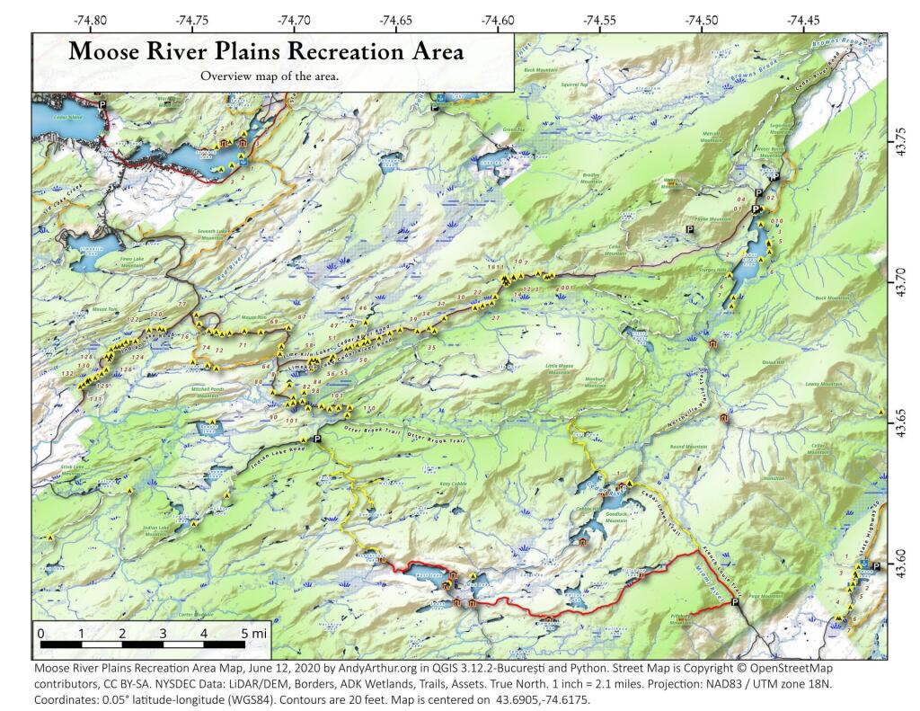
Overview map of Moose River Plains. This shows the location of the campsites and major trails throughout the area. I probably could improve on this map, but I think this does give on a good overview that can be easily printed on an 8x11" sheet of paper.
An overview map and list of campsites and their locations at the Moose River Recreation Area.
| Milepoint | Name | Feature | Notes | Access | Location | |||
|---|---|---|---|---|---|---|---|---|
| Cedar River Flow 1 | Cedar River Flow | Tent site on flow | Boat | 43.702924803151, -74.4871304116533 | ||||
| Cedar River Flow 2 | Cedar River Flow | Tent site on flow | Boat | 43.7104737708879, -74.4802343768254 | ||||
| Cedar River Flow 3 | Cedar River Flow | Tent site on flow | Boat | 43.7145237017622, -74.4679264444554 | ||||
| Cedar River Flow 5 | Cedar River Flow | Tent site on flow | Boat | 43.7111711590583, -74.4675178486588 | ||||
| Cedar River Flow 6 | Cedar River Flow | Tent site on flow | Boat | 43.7084767866376, -74.4717703157492 | ||||
| Beaver Lake Campsite | Beaver Lake | Site overlooks Beaver Lake | Hike | 43.6516613421651, -74.7407833400961 | ||||
| 81 | Icehouse Pond | Accessible site at Icehouse Pond with privy | Hike | 43.6646602166505, -74.7029502913239 | ||||
| 140A | Indian Lake | Campsite on Indian Lake, outhouse in bad condition | Hike | 43.6154753632731, -74.7499942080732 | ||||
| East of Muskrat Pond | Indian Lake Trail | Former roadside campsite, largely abandoned | Hike | 43.645116528704, -74.696221627206 | ||||
| 46 | Lost Ponds Trail | Beyond the end of current Lost Ponds Road | Hike | 43.6868179572109, -74.6655581886723 | ||||
| 47 | Lost Ponds Trail | Above Lost Ponds | Hike | 43.6859472953826, -74.6722052916864 | ||||
| Mitchell Pond 1 | Mitchell Pond | Tent site, bushwhack | Hike | 43.6729475881673, -74.7502538624373 | ||||
| Mitchell Pond 2 | Mitchell Pond | Tent site, bushwhack | Hike | 43.6716991892117, -74.7432124817486 | ||||
| 64A | Mitchell Pond (Accessible Campsite at End of Gravel Trail) | Gravel path to site, wildrness privy | Hike | 43.6706136251028, -74.7387363015355 | ||||
| 10 | 89 | Beaver Lake Road | Off Otter Brook Road, Sand Plains | Vehicle | 43.6583112347181, -74.7012491214803 | |||
| 11 | 90 | Beaver Lake Road | Off Otter Brook Road, Sand Plains | Vehicle | 43.6577446555162, -74.7038760912165 | |||
| 16 | 1 | Cedar River – Limekiln Lake Road | Driveway Along Tributary of Silver Run | Vehicle | 43.7033162602551, -74.5742148239156 | |||
| 16 | 3 | Cedar River – Limekiln Lake Road | Along Silver Run | Vehicle | 43.7027301523306, -74.5757742464803 | |||
| 16 | 4 | Cedar River – Limekiln Lake Road | Along Silver Run, driveway at Sharp S Turn | Vehicle | 43.7026421104662, -74.5769731929134 | |||
| 16 | 7 | Cedar River – Limekiln Lake Road | Along Silver Run | Vehicle | 43.7040070126376, -74.5809411044503 | |||
| 15 | 10 | Cedar River – Limekiln Lake Road | Old gravel pit, accessible | Vehicle | 43.7031498027862, -74.5893864145496 | |||
| 15 | 11 | Cedar River – Limekiln Lake Road | Across from 12 | Vehicle | 43.702458607149, -74.5926546451668 | |||
| 15 | 12 | Cedar River – Limekiln Lake Road | Across from 11 | Vehicle | 43.7028667147947, -74.5929833340894 | |||
| 15 | 13 | Cedar River – Limekiln Lake Road | Along Silver Run | Vehicle | 43.7010402113051, -74.5956355707995 | |||
| 15 | 14 | Cedar River – Limekiln Lake Road | Along Silver Run | Vehicle | 43.7010328498576, -74.597457469967 | |||
| 14 | 16 | Cedar River – Limekiln Lake Road | Access Road for 16/17/18 Group | Vehicle | 43.7025294616695, -74.5969885248639 | |||
| 14 | 17 | Cedar River – Limekiln Lake Road | Access Road for 16/17/18 Group | Vehicle | 43.7021028692463, -74.5966599329259 | |||
| 14 | 18 | Cedar River – Limekiln Lake Road | Access Road for 16/17/18 Group | Vehicle | 43.7023846304313, -74.5978818600647 | |||
| 14 | 19 | Cedar River – Limekiln Lake Road | Along Silver Run | Vehicle | 43.7003546491841, -74.5964872856253 | |||
| 14 | 21 | Cedar River – Limekiln Lake Road | Across road from Silver Run | Vehicle | 43.6957217888458, -74.6020563094081 | |||
| 13 | 22 | Cedar River – Limekiln Lake Road | Across road from Silver Run | Vehicle | 43.6935817523545, -74.6036764840587 | |||
| 13 | 27 | Cedar River – Limekiln Lake Road | Across road from Silver Run | Vehicle | 43.6926540634024, -74.6082201775478 | |||
| 13 | 30 | Cedar River – Limekiln Lake Road | Open Area in Woods | Vehicle | 43.6918525577623, -74.6118452191364 | |||
| 13 | 31 | Cedar River – Limekiln Lake Road | Near Marsh off Silver Run | Vehicle | 43.6881856235873, -74.6271629609656 | |||
| 12 | 34 | Cedar River – Limekiln Lake Road | Open Field Near Old Sly Pond Road | Vehicle | 43.6846954329325, -74.634678249126 | |||
| 12 | 35 | Cedar River – Limekiln Lake Road | Former Sly Pond Road | Vehicle | 43.6836690328942, -74.6318552827363 | |||
| 11 | 38 | Cedar River – Limekiln Lake Road | On Hill Overlooking Road, near start of Lost Ponds Area | Vehicle | 43.6836029270341, -74.6401393590772 | |||
| 11 | 39 | Cedar River – Limekiln Lake Road | Above CRLLR, start of Lost Ponds Area | Vehicle | 43.6841476346233, -74.6487511980121 | |||
| 11 | 40 | Cedar River – Limekiln Lake Road | Above CRLLR, start of Lost Ponds Area | Vehicle | 43.682942162164, -74.6537793571789 | |||
| 11 | 41 | Cedar River – Limekiln Lake Road | Above CRLLR, start of Lost Ponds Area | Vehicle | 43.681311345096, -74.6589116717693 | |||
| 10 | 42 | Cedar River – Limekiln Lake Road | Above CRLLR, start of Lost Ponds Area | Vehicle | 43.6799039050817, -74.6646031695507 | |||
| 10 | 43 | Cedar River – Limekiln Lake Road | Above CRLLR, start of Lost Ponds Area | Vehicle | 43.6793727911294, -74.6664156654099 | |||
| 10 | 44 | Cedar River – Limekiln Lake Road | West of Lost Ponds Road, Sand Plains | Vehicle | 43.678808787762, -74.6696555368193 | |||
| 10 | 50 | Cedar River – Limekiln Lake Road | West of Lost Ponds Road, Sand Plains | Vehicle | 43.677986610504, -74.6732025802129 | |||
| 10 | 51 | Cedar River – Limekiln Lake Road | Pull-Off, Small Site, Sand Plains | Vehicle | 43.6775108499728, -74.6750146421403 | |||
| 10 | 52 | Cedar River – Limekiln Lake Road | Old gravel pit, short loop below CRLLR | Vehicle | 43.6748840847288, -74.6815273754233 | |||
| 10 | 53 | Cedar River – Limekiln Lake Road | Access Road for 55/54/55 Group, Sand Plains | Vehicle | 43.6733317629897, -74.6820452615144 | |||
| 10 | 54 | Cedar River – Limekiln Lake Road | Access Road for 55/54/55 Group, Sand Plains | Vehicle | 43.673268538603, -74.6822820352903 | |||
| 9 | 55 | Cedar River – Limekiln Lake Road | Access Road for 55/54/55 Group, Sand Plains | Vehicle | 43.6733705968856, -74.6827076379887 | |||
| 9 | 56 | Cedar River – Limekiln Lake Road | Driveway, East of Former Dump, Sand Plains | Vehicle | 43.673126585883, -74.6891475571674 | |||
| 9 | 57 | Cedar River – Limekiln Lake Road | Has Trail to Moose River | Vehicle | 43.6736673106707, -74.6902687046523 | |||
| 8 | 64 | Cedar River – Limekiln Lake Road | Near Mitchell Pond Trail | Vehicle | 43.6757521870177, -74.707500815672 | |||
| 8 | 66 | Cedar River – Limekiln Lake Road | Near Pine Creek | Vehicle | 43.6784203854214, -74.7068492021325 | |||
| 7 | 67 | Cedar River – Limekiln Lake Road | Benedict Creek Road, Wooded | Vehicle | 43.6851041444828, -74.7031887110586 | |||
| 7 | 69 | Cedar River – Limekiln Lake Road | Remote site, perched over the road | Vehicle | 43.6834516958835, -74.7168906980223 | |||
| 6 | 70 | Cedar River – Limekiln Lake Road | Large loop off of CRLLR | Vehicle | 43.6839906014562, -74.7249870178447 | |||
| 6 | 71 | Cedar River – Limekiln Lake Road | Very sandy site near Mitchells Pond Upper Loop | Vehicle | 43.6833776353921, -74.7321947941391 | |||
| 5 | 72 | Cedar River – Limekiln Lake Road | At end of Bear Pond Loop Road (Accessable) | Vehicle | 43.6828956047277, -74.7359084701559 | |||
| 4 | 73 | Cedar River – Limekiln Lake Road | Very sandy site near Mitchells Pond Upper Loop | Vehicle | 43.6835777053685, -74.7387188889593 | |||
| 4 | 74 | Cedar River – Limekiln Lake Road | On a hill overlooking road and marshy area | Vehicle | 43.6839187521201, -74.742285779317 | |||
| 4 | 76 | Cedar River – Limekiln Lake Road | Very sandy site near Mitchells Pond Upper Loop | Vehicle | 43.6864452702399, -74.7471689344191 | |||
| 4 | 77 | Cedar River – Limekiln Lake Road | Near Red River, Bear Pond Loop, Sand Plains | Vehicle | 43.6897961458669, -74.7484803840413 | |||
| 10 | 58 | Helldiver Pond Road | Near Helldiver Pond | Vehicle | 43.6735979105991, -74.6920316000423 | |||
| 10 | 59 | Helldiver Pond Road | Near Helldiver Pond | Vehicle | 43.6723766419894, -74.6929318681131 | |||
| 10 | 60 | Helldiver Pond Road | Near Helldiver Pond | Vehicle | 43.6713193532923, -74.692758456613 | |||
| 10 | 61 | Helldiver Pond Road | Accessible site at end of Helldiver Pond Road | Vehicle | 43.6705019900204, -74.6921751440693 | |||
| 15 | West of Brooktrout Trail | Indian Lake Road | Past Brooktrout Trail, on a hill over road | Vehicle | 43.6254538914434, -74.7337300739322 | |||
| 10 | 48 | Lost Pond Road | Sand Plains, Marshes Aroubnd | Vehicle | 43.6814268347573, -74.6667101324338 | |||
| 11 | 49 | Lost Pond Road | Sand Plains, Marshes Aroubnd | Vehicle | 43.6819456385478, -74.6670131106595 | |||
| 10 | 80 | Otter Brook Road | Has Trail to Moose River | Vehicle | 43.6620917920003, -74.7112181918076 | |||
| 11 | 98 | Otter Brook Road | Above Moose River on Hill | Vehicle | 43.6588725644731, -74.6966603409996 | |||
| 11 | 101 | Otter Brook Road | Sand Plains | Vehicle | 43.6564420559443, -74.6938956128147 | |||
| 11 | 103 | Otter Brook Road | Sand Plains | Vehicle | 43.657108724794, -74.6873446316172 | |||
| 12 | 104 | Otter Brook Road | Wooded Site | Vehicle | 43.6560617426567, -74.6832992891923 | |||
| 12 | 106 | Otter Brook Road | Wooded Site | Vehicle | 43.6565121581975, -74.6789913497265 | |||
| 13 | 110 | Otter Brook Road | Wooded Site | Vehicle | 43.6566072628101, -74.6733859460379 | |||
| 13 | 111 | Otter Brook Road | Near Otter Brook Bridge | Vehicle | 43.6539235327721, -74.6747718892435 | |||
| 23 | 1 | Wakely Dam Camping Area | Accessible site | Vehicle (before gate) | 43.7266767212397, -74.474100266424 | |||
| 23 | 2 | Wakely Dam Camping Area | Field Camping | Vehicle (before gate) | 43.7266515010084, -74.4733110730078 | |||
| 23 | 3 | Wakely Dam Camping Area | Field Camping | Vehicle (before gate) | 43.7259595122959, -74.473899965642 | |||
| 23 | 4 | Wakely Dam Camping Area | On Driveway to Lake | Vehicle (before gate) | 43.7260676922081, -74.4742326471903 | |||
| 23 | 5 | Wakely Dam Camping Area | On Driveway to Lake | Vehicle (before gate) | 43.7255637908987, -74.4741751228291 | |||
| 23 | 6 | Wakely Dam Camping Area | On Driveway to Lake | Vehicle (before gate) | 43.7252231337487, -74.4745830371916 | |||
| 23 | 9 | Wakely Dam Camping Area | Across bridge | Vehicle (before gate) | 43.726275356142, -74.4717840349063 | |||
| 23 | 10 | Wakely Dam Camping Area | Across bridge | Vehicle (before gate) | 43.7266308152758, -74.4712600272389 | |||
| 10 | 82 | Otter Brook Road | On Moose River | Vehicle (driveway) | 43.6603083771227, -74.7010353925305 | |||
| 11 | 84 | Otter Brook Road | On Moose River | Vehicle (driveway) | 43.6619962517853, -74.6957783254417 | |||
| 6 | 120 | Natural Rock Dam Road | Sand Plains near Red River | Vehicle (Opens July) | 43.6848543033273, -74.7664253595203 | |||
| 6 | 122 | Natural Rock Dam Road | Wooded Site | Vehicle (Opens July) | 43.684367353989, -74.7717171949716 | |||
| 6 | 123 | Natural Rock Dam Road | Wooded Site | Vehicle (Opens July) | 43.6804228755091, -74.7782951743141 | |||
| 6 | 124 | Natural Rock Dam Road | Wooded Site | Vehicle (Opens July) | 43.6792030487765, -74.7847972548314 | |||
| 7 | 125 | Natural Rock Dam Road | Wooded Site | Vehicle (Opens July) | 43.6783559964111, -74.7880327043169 | |||
| 7 | 126 | Natural Rock Dam Road | Wooded Site | Vehicle (Opens July) | 43.6748535298235, -74.790591643043 | |||
| 7 | 127 | Natural Rock Dam Road | Wooded Site | Vehicle (Opens July) | 43.6739776362472, -74.7910844137006 | |||
| 7 | 128 | Natural Rock Dam Road | Wooded Site | Vehicle (Opens July) | 43.6751413481917, -74.7924842843025 | |||
| 8 | 129 | Natural Rock Dam Road | Wooded Site | Vehicle (Opens July) | 43.6703784784539, -74.7926312803463 | |||
| 8 | 130 | Natural Rock Dam Road | Wooded Site | Vehicle (Opens July) | 43.6666270858056, -74.8019151989726 | |||
| 8 | 131 | Natural Rock Dam Road | Wooded Site | Vehicle (Opens July) | 43.6643581634434, -74.8054154753831 | |||
| 8 | 132 | Natural Rock Dam Road | Wooded Site | Vehicle (Opens July) | 43.6652083016168, -74.8036826184027 | |||
| 5 | 119A | Natural Rock Dam Road | Sand Plains near Red River | Vehicle (Opens July) | 43.6844716021433, -74.7646961785253 | |||
| 6 | 123A | Natural Rock Dam Road | Wooded Site | Vehicle (Opens July) | 43.6802422604152, -74.782965042166 | |||
| 6 | 124A | Natural Rock Dam Road | Wooded Site | Vehicle (Opens July) | 43.6785899888224, -74.7864319884685 | |||
| 6 | 125A | Natural Rock Dam Road | Wooded Site | Vehicle (Opens July) | 43.6776017274889, -74.7902229325712 | |||
| 7 | 126A | Natural Rock Dam Road | Wooded Site | Vehicle (Opens July) | 43.6756110574941, -74.7901645681643 | |||
| 8 | 129A | Natural Rock Dam Road | Wooded Site | Vehicle (Opens July) | 43.6689370211979, -74.7948887917477 | |||
| 8 | 129AA | Natural Rock Dam Road | Wooded Site | Vehicle (Opens July) | 43.6674497436753, -74.7980604042935 | |||
| 8 | 130A | Natural Rock Dam Road | Wooded Site | Vehicle (Opens July) | 43.6661052974262, -74.8016557609016 | |||
| 8 | 130AA | Natural Rock Dam Road | Wooded Site | Vehicle (Opens July) | 43.6669094078356, -74.8007390664074 |
I thought my Moose River Trip was a pretty good one, even if I ran into some minor issues along the way.
It was a pretty foggy start to my morning when I first woke up with the fog picking up right before eight AM then burning off a little while after the sun rose. While Friday and Saturday nights were fairly chilly the same could not be said about last night. Yesterday was pretty nice paddling along the Cedar River Flow then up on Cedar River to Carry Lean-To, which as the name suggests is close to the end of the navigable waters on the river. Maybe you can “carry” and get to another section of deep enough water but I have my doubts. The leaves along the flow were quite colorful, although the mountains surrounding the flow where already past peak and starting to turn quite brown and gray, with only some deep reds from the maples and greens from the evergreens remaining. It seems ironic that Moose River Plains is already looking like late fall, with the weather still in the 80s. Cool weather, some with a frost in early September made the leaves fall on many of the trees, despite the big warm up of this weekend.
While I don’t know how truly warm it got up here on Sunday — September 24th I should note — my phone said it was 87 degrees by mid afternoon, and the water in the Cedar River wasn’t super cold. I went swimming every day I was up here. The weather this weekend was warmer then it was when I camped up here over the Independence Day Weeekend. So be it.
I got lost in the muck and vegetation looking for the Cedar River, which if your inexperienced paddling or been a while since the last time on the Cedar River Flow can be quite difficult to find. Fortunately I saw a passing kayaker and he gave me verbal advice on how to find the river. I had a topographic map on my phone but it’s only of limited use, because topographic maps are old, and do not reflect the lower lake level since the DEC put in the modern dam in 1969.
There was a dreaded beaver dam on the Cedar River, only a short distance from the entrance from the flow. I am really quite surprised a beaver dam survived the boats crossing the area and the trappers seeking beaver pelts. I guess beaver pelts haven’t been fetching the price they once did, and with less human pressures, beavers are able to build an dam up whatever they want these days.
Coming back over the Beaver Dam the second time, I managed to flip my kayak getting back into it. My smartphone stayed plenty dry in it’s protective bag, but my camera and tackle box got soaked. Well, only briefly, but my camera is drying out and I assume in a day or two it will be fine to power back up again. So for the last day of my trip, I am limited to smartphone pictures.
I haven’t paddled the Cedar River Flow in a while because I have been spending more time up in the western end of Moose River Plains, and it’s a big haul back there. At 15 MPH speed limit, it takes almost an hour. From Wakely Dam to Carry Lean-to, it’s an hour and a half paddle, assuming you find the entrance to the river with ease and don’t stop for an hour for lunch, personal business on the smartphone, and of course updating social media. I know, hah. But there is good AT&T GSM access from the upper end of Cedar River Flow, especially near Campsite 6. That’s not as common in much of the Moose River Recreation Area.
Driving to the Cedar River Flow from the camping area in the western part of the Moose River Plains near Helldiver is an hour long proposition, which is why I haven’t spent much time there lately. I’ve also been spending more time exploring things around Inlet, in part because I like being able to check my phone to see if any family or work things come on up. I also get a bit tired of all those bumpy miles of 15 MPH road, especially now that I know Cedar River – Limekiln Lake Road like the back of my hand.
I cooked up some beef, cheese and chilies, and had some more burritos with Corona beer. After a few beers, with the hot sun all day, the five hours of paddling, I watched the fire for a bit then I retired for the night. I was probably in bed by nine. Which seems silly, as it was it was a pleasant evening with billions of stars above and temperatures in the 60s, but I felt like I needed toothpicks to keep my eyes open. I’ve also been trying to get more sleep these days.
In the past few years, I’ve camped up at Moose River Plains but it’s been at least two years since I camped in the plains formal — the area where the campsites are sand, the canopies are open and the surrounding area is quite swampy. The reason for not camping up here is quite simple — the bugs can be quite horrific during the spring and early summer — while the surrounding wooded sites tend to be bug free or have much fewer mosquitoes. It can be like night or day, especially in black fly season.
That said the “plains” campsites just are a special place to camp at with the big starry skies above in the remote country. I really enjoyed campsite 80, and should try to make sure to camp up here more often.
Broke camp before ten, walked down to the Moose River. Cooked up biscuits in the camp oven, took down the flags, put away the gear, hung out the wet stuff to dry, worked on the blog post, and once the fog burnt off it was a beautiful but rapidly warming morning as the leaves continued to fall.
First tried my hand at fishing the Moose River from the path behind my campsite, then I drove to the bridge over the Moose River and fished under there. Caught nothing. Hiked back from the Squaw Lake parking area first to Muskrat Pond and then to Indian Lake, that is the one in the southwestern most part of Moose River Plains. Nice hike, although at this point some of the colors are already done. Other places, less color. It varies a lot with elevation. But regardless the weather on this extended weekend has been amazing.
I tell you there aren’t many 80 degree days during the last week of September in the Adirondacks. It was nice sitting down by the lake with a fishing pole, even if I only caught a few bullheads. No mosquitoes which was nice too. And I almost slipped and fell in the lake which honestly today wouldn’t have been the worse thing. They’ve removed most of the signs and tables from the old campsites along the closed portion of Indian Lake Road, even if it’s in better condition than the open portion. The open portion of Indian Lake Road has been beat to shit by trucks and cars due to it being so wet and rainy this summer. Good colors along the road though. Definitely a beautiful day, not too humid with a lot of fair weather clouds.
Apparently I don’t have cell service up at Indian Lake or Muskrat Pond with my GSM phone like my old CDMA model. That’s fine but I do like to check in with the world from time to time. Oh well, by the time you read this I will be back in cellphone range.
I was looking at the map and thinking I have never hiked back to the Indian River. I didn’t have time today but I should add that to my list for next summer. Also hiking back to Cellar Pond by Cellar Monument now that the DEC has a big sign announcing the trail and they’ve blocked off the old dirt track used by hunters to drive down that way. I always go to the same places at Moose River Plains, I should explore new places.
After visiting Muskrat Pond, Indian Lake, and Squaw Lake I made it back to my truck closer to four PM then three. And I was at the Inlet gate around five, when I stopped and put the front and back ropes back on the kayak, and headed back via Old Forge.I didn’t feel like driving all the way back through Moose River Plains to Indian Lake, and heck, I haven’t been back via NY 28 in a long time.
Driving back through Inlet and Old Forge was really quiet. It was nice to be on the nice smooth black top, after driving over Indian Lake Road, the little used and little maintained section between the Falls Pond and Squaw Lake Trailhead was particularly rough. The sound of windshield washer fluid hitting the kayak on NY 28 made me pull over, but it was just that noise, the kayak was riding fine. But in general it seemed like all of the roads at Moose River Plains were rougher then usual after such a wet summer, with some heavy rains eroding away the roads and vehicles giving the road a good pounding in spots. I thought there was a McDonalds in Old Forge where I could get a milk shake, but I couldn’t find it.
NY 28 except for the small towns is really a good road, if not boring. The DOT has straightened and improved much of the road except through the small towns. Without summer vacationer traffic and being a weekday, there was very little traffic. I always like that section of NY 28 when it meets up with NY 12 south of Alder Creek, and becomes a four lane, but I think people always seem to speed on it and there are always cops watching for speeders. But the scenery is nice along this section of the road, looking down at the Mohawk Valley and the rough farm country, and swamp land of the greater Remsen area. I always find the rocky, rough farms cut into the mountains to be much more interesting to look at then the lush, more heavily capitalized and better maintained farms of the lush alluvial valleys you see in some parts of the state. The Tug Hill, in it’s upper elevations is a rough country, with lots of snow, and very hardy people. A big black F-350 Harvey Davidson edition passed by with Agriculture plates, and I had to think, “he must do some good shit, “no pun intended”.
Drove down to Poland and Middleville via NY 28. I like this part of NY 28 even if the villages are pokey, just because it’s pretty along the East Canada Creek. I should try my hand trout fishing there one spring — I just got to find a good place to camp up that way — it’s a bit of a trip for a day trip from Albany in my opinion. Middleville is quite the quaint little town, reminding me of what America used to be like.
Then it was down to NY 169 to Little Falls from Herkimer. I like this section of road, even though it’s hilly, because it’s quite beautiful. I like seeing the farms and valleys, and a landscape that works but isn’t that perfect, and still somewhat rough. Drove through Little Falls, a nice little but struggling city that has much potential. Yeah, I was there last weekemd at Moss Island, then onwards toward the Thruway. Stopped at Fink Basin Road to tighten the kayak on the roof of my truck.
Right before getting on the Thruway, I decided to shun pike some more, and take NY 5S from the Little Falls exit to Canjahoharie. I don’t like having to drive through Fort Plain and then Canjahoharie before getting onto he Thruway, but so be it. I do like that section of NY 5S high above the valley though. Some farms in the valleys haven’t cut silage yet due to the high temperatures (more growing seasons, more yields) and lack of frost.
When I got to Fort Plain I almost stopped at the Red Dragon Chinese place. I like Chinese and they tend to be inexpensive. People always think small town Chinese places are bad, but actually some can be pretty good, especially if families are trying to make a living in a place with few other options. I liked the Chinese I got in Canastota when I was working there, but then again, I got awful tasting Chinese food in North Syracuse. I don’t know, I passed as it was getting dark and I wanted to get home.
When I got on the Thruway at Canjahoharie it was getting pretty dark. My eyes were watering up and I ended up stopping at the rest area outside of Amsterdam. Took a piss and washed my hands good — nice bathrooms — then went into my truck and cleaned off my contacts and reinstered them. That made the rest of the drive easier.
Got home around 8 PM and things unpacked, well mostly so, before the heat started to get to me. Then I took a shower, and finished up this blog post. And here we are now.
My current smartphone isn’t as good at picking up distant radio channels and I didn’t play with it much so I missed hearing the news during my extended weekend trip at Moose River Plains. I doubt I missed much, most of the things in the news don’t effect me much. I’m sure my political Facebook friends will post plenty of memes to fill me in on what I’ve been missing.
Among other things, the amendment would incorporate proposals identified by the International Mountain Bike Association as part of a comprehensive mountain bike trail plan prepared for the Department of Environmental Conservation. Specifically, it would expand opportunities for single-track riding in the Moose River Plains area; concentrate bicycling to specific areas and monitor the level of use; expand bicycling adjacent to highly visited areas such as DEC’s Eighth Lake Campground and Great Camp Sagamore; and connect the trail system to nearby towns and communities.
It would also provide additional recreational opportunities for persons with disabilities. Specifically, the plan calls for modifying the Eighth Lake Canoe Carry/Mike Norris Trail and the Eighth Lake lean-to and related facilities for persons with disabilities. The state would also construct a universal access trail and picnic area east of the new Route 28 parking area.
"Hamilton County Superintendent of Highways Tracy Eldridge says about 13.3 miles of road within the Moose River Plains desperately need gravel, but it would cost about $25,000."
"The Hamilton County Board of Supervisors approved a service contract between the county and the New York State Department of Environmental Conservation in April under which the DEC will pay up to $90,000 over three years ($30,000 per year) for road maintenance within the Moose River Recreation Area.
"This is just for culvert and grading work."