Ithaca – 1995, 2002, 2006, 2011, 2012, 2014, 2018, 2023
NYS ITS posted aerial photography of Ithaca and Tompkins County taken during the spring of 2023 today.
NYS ITS posted aerial photography of Ithaca and Tompkins County taken during the spring of 2023 today.
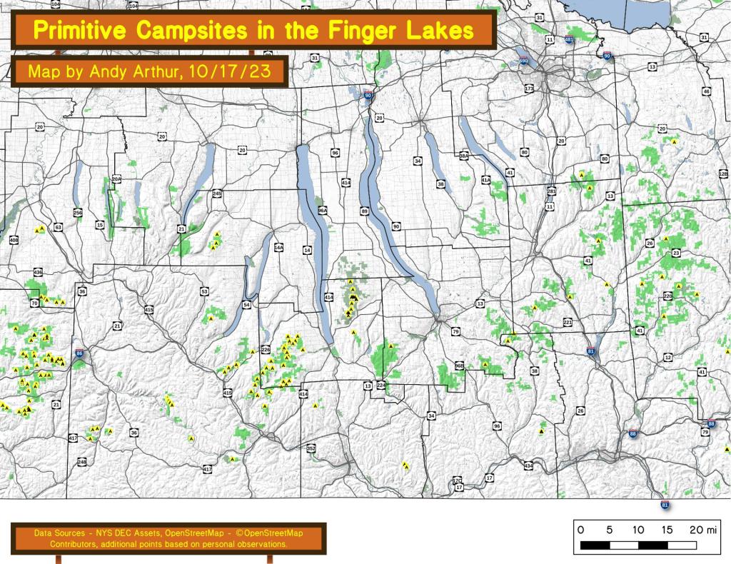
An overview of free primitive and roadside campsites located throughout the Finger Lakes region of New York State including Chemung County, Tioga County, Tompkins County, Steuben County, and Schuyler County. Major areas include the Sugar Hill State Forest and Recreation Area and the Finger Lakes National Forest. You can see more detailed locations by exploring this Interactive Google Map (KML) of the campsites across the state.
Counties: Albany to Delaware / Dutchess to Livingston / Madison to Otsego / Putnam to Suffolk / Sullivan to Yates
Browse Topographic Maps: Full State / Historical USGS Topographic Maps
Counties: Albany to Delaware / Dutchess to Livingston / Madison to Otsego / Putnam to Suffolk / Sullivan to Yates
Browse Topographic Maps: Full State / Historical USGS Topographic Maps
Most of the largest cities and towns in each county is well known, and in many cases it is the county seat. Starred towns in Italic are county seats.
| County – Largest Municipality | Population |
| Albany County – Albany city* | 97,279 |
| Allegany County – Wellsville town | 6,974 |
| Broome County – Union town | 53,251 |
| Cattaraugus County – Olean city | 13,597 |
| Cayuga County – Auburn city* | 26,454 |
| Chautauqua County – Jamestown city | 29,315 |
| Chenango County – Norwich city* | 6644 |
| Chemung County – Elmira city* | 27,204 |
| Clinton County – Plattsburgh city* | 19,438 |
| Columbia County – Kinderhook town | 8,215 |
| Cortland County – Cortland city* | 18,713 |
| Delaware County – Sidney town | 5,367 |
| Dutchess County – Poughkeepsie town | 44,035 |
| Erie County – Buffalo city* | 256,304 |
| Essex County – North Elba town | 8,094 |
| Franklin County – Malone town* | 14,139 |
| Fulton County – Gloversville city | 14,832 |
| Genesee County – Batavia city* | 14,491 |
| Greene County – Catskill town* | 11,364 |
| Hamilton County – Indian Lake town | 1,245 |
| Herkimer County – German Flatts town | 12,547 |
| Jefferson County – Watertown city | 25,290 |
| Lewis County – Lowville town* | 4,840 |
| Livingston County – Geneseo town* | 10,691 |
| Madison County – Sullivan town | 15,149 |
| Monroe County – Rochester city* | 206,284 |
| Montgomery County – Amsterdam city | 17,864 |
| Nassau County – Hempstead town | 768,103 |
| Niagara County – Niagara Falls city* | 48,144 |
| Oneida County – Utica city* | 60,100 |
| Onondaga County – Syracuse city* | 142,749 |
| Ontario County – Victor town | 15,069 |
| Orange County – Warwick town | 31,185 |
| Orleans County – Albion town* | 8,138 |
| Oswego County – Oswego city* | 17,337 |
| Otsego County – Oneonta city | 13,918 |
| Putnam County – Carmel town* | 34,245 |
| Rensselaer County – Troy city* | 49,374 |
| Rockland County – Ramapo town | 136,848 |
| Saratoga County – Clifton Park town | 36,566 |
| Schenectady County – Schenectady city* | 65,575 |
| Schoharie County – Cobleskill town | 6,239 |
| Schuyler County – Hector town | 4,933 |
| Seneca County – Seneca Falls town | 8,680 |
| St. Lawrence County – Potsdam town | 15,322 |
| Steuben County – Bath town | 11,938 |
| Suffolk County – Brookhaven town | 482,436 |
| Sullivan County – Thompson town | 15,019 |
| Tioga County – Owego town* | 18,843 |
| Tompkins County – Ithaca city* | 30,999 |
| Ulster County – Kingston city* | 22,950 |
| Warren County – Queensbury town* | 27,471 |
| Washington County – Kingsbury town | 12,346 |
| Wayne County – Arcadia town | 13,564 |
| Westchester County – Yonkers city | 199,663 |
| Wyoming County – Attica town | 7,021 |
| Yates County – Milo town | 6,811 |
Interactive Google Map consisting of federal, state, local, and non-governmental public lands and parks within the following counties in DEC Region 7 South: Broome, Chenango, Cortland, Tioga and Tompkins counties. Up to 5 additional counties (for a total of ten) can be added to the map. Data can be downloaded as KML and GPX Tracks and Waypoints for use in Google Earth or handheld GPS units.
Updated March 25, 2017. New to this update are trail data for Buttermilk Falls State Park, Robert Treman, and Taughannock Falls State Park. New lean-tos, campsites, parking areas, and trails, roads added to state forests. Minor adjustments to state land boundaries.


