Search Results for: map sugarloaf mountain
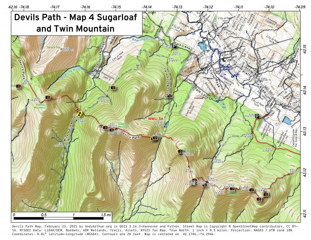
Devil’s Path
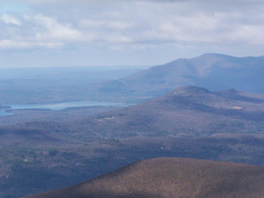
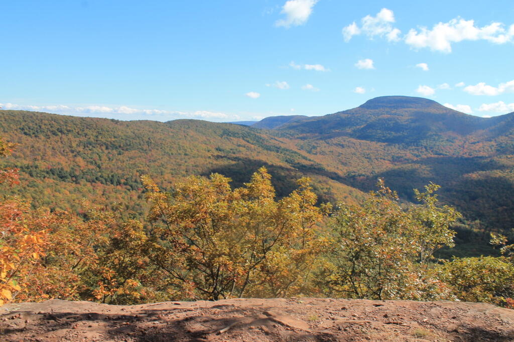
The Devil's Path is a challenging hiking trail located in the Catskill Mountains of New York State, renowned for its rugged terrain and demanding ascents and descents. Spanning approximately 25 miles in length, the Devil's Path traverses six major peaks within the Catskills, including Indian Head, Twin, Sugarloaf, Plateau, West Kill, and Hunter Mountains. This trail is notorious among hikers for its steep and rocky sections, as well as its significant elevation gains and losses. The Devil's Path offers stunning panoramic views of the surrounding wilderness.
The trail is divided into two main sections: the eastern and western halves, with each presenting its own set of challenges and scenic vistas. Hiking the entire Devil's Path is considered a formidable accomplishment and is often completed over the course of two or three days by experienced backpackers and outdoor enthusiasts.
Peaks Over 3,000 Feet Elevation in New York State
There are 229 summits in New York State greater then 3,000 feet elevation.
| Tallest Peak | Summit Name | Elevation | County | USGS Topo Map Name | State Land | Trail | Location |
|---|---|---|---|---|---|---|---|
| 1 | Mount Marcy | 5,344 | Essex | Mount Marcy | High Peaks Wilderness | NA | 44.112733, -73.9237833 |
| 2 | Algonquin Peak | 5,105 | Essex | North Elba | High Peaks Wilderness | Algonquin Trail | 44.1436636, -73.9865357 |
| 3 | Mount Haystack | 4,924 | Essex | Mount Marcy | High Peaks Wilderness | Haystack Trail Via Barklet Ridge | 44.1056093, -73.9004196 |
| 4 | Mount Skylight | 4,908 | Essex | Mount Marcy | High Peaks Wilderness | Skylight Trail | 44.0994987, -73.9306986 |
| 5 | Basin Mountain | 4,852 | Essex | Mount Marcy | High Peaks Wilderness | State Range Trail | 44.1211639, -73.8862527 |
| 6 | Iroquois Peak | 4,829 | Essex | North Elba | High Peaks Wilderness | Iroquois Herd Path Via Boundary Peak | 44.1369973, -73.9982027 |
| 7 | Boundary Peak | 4,826 | Essex | North Elba | High Peaks Wilderness | Iroquois Herd Path Via Boundary Peak | 44.1397749, -73.9937582 |
| 8 | Whiteface Mountain | 4,816 | Essex | Lake Placid | Whiteface Mountain Ski Center | Whiteface Landing To Whiteface Mtn. Trail | 44.3658804, -73.9026456 |
| 9 | Dix Mountain | 4,813 | Essex | Dix Mountain | High Peaks Wilderness | Elk Lake To Dix Mountain Trail | 44.0822756, -73.7862471 |
| 10 | Gray Peak | 4,800 | Essex | Mount Marcy | High Peaks Wilderness | Mount Marcy Trail Via Opalescent River | 44.1114427, -73.9348658 |
| 11 | Schofield Cobble | 4,744 | Essex | Mount Marcy | High Peaks Wilderness | NA | 44.1089427, -73.9270876 |
| 12 | Little Marcy | 4,728 | Essex | Mount Marcy | High Peaks Wilderness | Van Hoevenberg Trail To Marcy | 44.1197753, -73.910976 |
| 13 | Gothics | 4,724 | Essex | Keene Valley | High Peaks Wilderness | Beaver Meadow Falls Trail | 44.1281079, -73.8570849 |
| 14 | Mount Colden | 4,708 | Essex | North Elba | High Peaks Wilderness | Mount Colden Via Lake Arnold | 44.1269976, -73.9598674 |
| 15 | Beck-horn | 4,695 | Essex | Dix Mountain | High Peaks Wilderness | Elk Lake To Dix Mountain Trail | 44.0800534, -73.7845802 |
| 16 | Little Haystack | 4,678 | Essex | Mount Marcy | High Peaks Wilderness | Haystack Trail Via Slant Rock | 44.1103313, -73.9004197 |
| 17 | Giant Mountain | 4,623 | Essex | Rocky Peak Ridge | Giant Mountain Wilderness | North Trail To Giant Mtn. | 44.161165, -73.720279 |
| 18 | Mount Redfield | 4,603 | Essex | Mount Marcy | High Peaks Wilderness | Mt Redfield Trail | 44.094777, -73.949866 |
| 19 | Santanoni Peak | 4,596 | Essex | Santanoni Peak | High Peaks Wilderness | Bradley Pond Trail | 44.0822811, -74.1309855 |
| 20 | Wright Peak | 4,564 | Essex | North Elba | High Peaks Wilderness | Wright Peak Spur Trail | 44.1517187, -73.9801468 |
| 21 | Nippletop | 4,554 | Essex | Dix Mountain | High Peaks Wilderness | Nipple Top Trail | 44.0892202, -73.8159708 |
| 22 | Saddleback Mountain | 4,534 | Essex | North Elba | High Peaks Wilderness | State Range Trail | 44.1264414, -73.8748634 |
| 23 | Panther Peak | 4,455 | Essex | Santanoni Peak | High Peaks Wilderness | Bradley Pond Trail | 44.0983915, -74.132097 |
| 24 | Rocky Peak | 4,403 | Essex | Rocky Peak Ridge | Giant Mountain Wilderness | East Trail To Giant Mtn. Via Rocky Peak Ridge | 44.1542177, -73.7051718 |
| 25 | Macomb Mountain | 4,396 | Essex | Dix Mountain | High Peaks Wilderness | Macomb-E. Dix Trail | 44.0517211, -73.7801349 |
| 26 | Hough Peak | 4,393 | Essex | Dix Mountain | High Peaks Wilderness | S. Dix-Hough Trail | 44.0694981, -73.7776352 |
| 27 | Mount Marshall | 4,380 | Essex | Street Mountain | High Peaks Wilderness | Mt Marshall Trail | 44.1275538, -74.0118142 |
| 28 | Armstrong Mountain | 4,360 | Essex | Keene Valley | High Peaks Wilderness | Adk Range Trail | 44.1347741, -73.8490291 |
| 29 | Seward Mountain | 4,327 | Franklin | Ampersand Lake | High Peaks Wilderness | Seymour Mountain Herd Path | 44.1597799, -74.1993239 |
| 30 | Allen Mountain | 4,321 | Essex | Mount Marcy | High Peaks Wilderness | Mt Redfield Trail | 44.0708892, -73.9395871 |
| 31 | Table Top Mountain | 4,295 | Essex | North Elba | High Peaks Wilderness | Table Top Mountain Trail | 44.143663, -73.9070876 |
| 32 | Big Slide Mountain | 4,232 | Essex | Keene Valley | High Peaks Wilderness | Big Slide Trail | 44.1822721, -73.8704202 |
| 33 | Esther Mountain | 4,232 | Essex | Franklin Falls | Wilmington Wild Forest | Esther Mt Trail | 44.3869916, -73.8898673 |
| 34 | MacIntyre Mountains | 4,193 | Essex | Street Mountain | High Peaks Wilderness | Mt Marshall Trail | 44.1308868, -74.008203 |
| 35 | Lower Wolfjaw Mountain | 4,190 | Essex | Keene Valley | High Peaks Wilderness | W.a. White Trail | 44.1483845, -73.8326399 |
| 36 | Upper Wolfjaw Mountain | 4,190 | Essex | Keene Valley | High Peaks Wilderness | Adk Range Trail | 44.1406072, -73.8451402 |
| 37 | Slide Mountain | 4,167 | Ulster | Peekamoose Mountain | Slide Mountain Wilderness | Burroughs Range Trail-Wittenberg-Cornell | 41.9987034, -74.3862617 |
| 38 | Phelps Mountain | 4,137 | Essex | North Elba | High Peaks Wilderness | Phelps Mtn. Trail | 44.1569957, -73.9209775 |
| 39 | Cascade Mountain | 4,094 | Essex | Keene Valley | High Peaks Wilderness | Casade Mountain Trail | 44.2186594, -73.860143 |
| 40 | South Dix | 4,088 | Essex | Dix Mountain | High Peaks Wilderness | Macomb-E. Dix Trail | 44.060054, -73.7743014 |
| 41 | Lookout Mountain | 4,078 | Essex | Franklin Falls | Whiteface Mountain Ski Center | Esther Mt Trail | 44.3778249, -73.887645 |
| 42 | Donaldson Mountain | 4,062 | Franklin | Ampersand Lake | High Peaks Wilderness | Seymour Mountain Herd Path | 44.1539471, -74.210991 |
| 43 | Seymour Mountain | 4,055 | Franklin | Ampersand Lake | High Peaks Wilderness | Seymour Mountain Herd Path | 44.1578347, -74.1721003 |
| 44 | Colvin Range | 4,049 | Essex | Dix Mountain | High Peaks Wilderness | Colvin Trail | 44.0939424, -73.8345829 |
| 45 | Mount Colvin | 4,049 | Essex | Dix Mountain | High Peaks Wilderness | Colvin Trail | 44.0939424, -73.8345829 |
| 46 | Hunter Mountain | 4,045 | Greene | Hunter | Hunter-West Kill Wilderness | Spruceton Trail | 42.1778662, -74.2304216 |
| 47 | Mount Emmons | 4,022 | Franklin | Ampersand Lake | High Peaks Wilderness | Northville-Placid Trail | 44.1436698, -74.2140464 |
| 48 | Street Mountain | 4,022 | Essex | Street Mountain | High Peaks Wilderness | Street Mountain Trail | 44.1797741, -74.0437616 |
| 49 | Grace Peak | 4,006 | Essex | Dix Mountain | High Peaks Wilderness | Macomb-E. Dix Trail | 44.0653314, -73.7573564 |
| 50 | Yard Mountain | 3,999 | Essex | North Elba | High Peaks Wilderness | Big Slide Trail Via Yard Mtn. | 44.1747725, -73.8845874 |
| 51 | MacNaughton Mountain | 3,983 | Essex | Street Mountain | High Peaks Wilderness | Wall Face Ponds Trail | 44.1397768, -74.064317 |
| 52 | Dial Mountain | 3,980 | Essex | Dix Mountain | High Peaks Wilderness | Leach Trail | 44.1058859, -73.7959703 |
| 53 | Blake Peak | 3,976 | Essex | Dix Mountain | High Peaks Wilderness | Pinnacle Trail | 44.081443, -73.844583 |
| 54 | Green Mountain | 3,976 | Essex | Rocky Peak Ridge | Giant Mountain Wilderness | North Trail To Giant Mtn. | 44.182272, -73.714858 |
| 55 | Black Dome | 3,973 | Greene | Freehold | Windham-Blackhead Range Wilderness | Blackhead Range Trail | 42.2700864, -74.1226382 |
| 56 | Thomas Cole Mountain | 3,944 | Greene | Hensonville | Windham-Blackhead Range Wilderness | Blackhead Range Trail | 42.2709196, -74.1365275 |
| 57 | Cliff Mountain | 3,940 | Essex | Mount Marcy | High Peaks Wilderness | Mount Marcy Trail Via Opalescent River | 44.1031102, -73.9751452 |
| 58 | McDonnel Mountain | 3,940 | Essex | Mount Marcy | High Peaks Wilderness | Mt Redfield Trail | 44.0803332, -73.9340315 |
| 59 | Blackhead | 3,930 | Greene | Freehold | Windham-Blackhead Range Wilderness | Blackhead Mountain Spur Trail | 42.2678644, -74.1045818 |
| 60 | West Kill Mountain | 3,891 | Greene | Lexington | Hunter-West Kill Wilderness | Devil’s Path | 42.1678663, -74.2895904 |
| 61 | Doubletop Mountain | 3,875 | Ulster | Seager | NA | Seager Big Indian Trail | 42.0275913, -74.5282095 |
| 62 | Nye Mountain | 3,871 | Essex | Street Mountain | High Peaks Wilderness | Nye Mountain Trail | 44.1931062, -74.0240387 |
| 63 | Kilburn Mountain | 3,868 | Essex | Lake Placid | Sentinel Range Wilderness | Copperas Owen Pond Trl | 44.3028247, -73.8818114 |
| 64 | Moose Mountain | 3,868 | Essex | McKenzie Mountain | Mckenzie Mountain Wilderness | Mckenzie Mtn. Trail | 44.3506029, -74.0032049 |
| 65 | Howard Mountain | 3,852 | Essex | North Elba | High Peaks Wilderness | Klondike Notch Trail | 44.1583844, -73.8912539 |
| 66 | Cornell Mountain | 3,848 | Ulster | Phoenicia | Slide Mountain Wilderness | Burroughs Range Trail-Wittenberg-Cornell | 42.0014812, -74.3568163 |
| 67 | Graham Mountain | 3,848 | Ulster | Seager | NA | Seager Big Indian Trail | 42.0392576, -74.5495986 |
| 68 | Plateau Mountain | 3,845 | Greene | Hunter | Indian Head Wilderness | Devil’s Path | 42.1378671, -74.1743088 |
| 69 | McKenzie Mountain | 3,842 | Essex | McKenzie Mountain | Mckenzie Mountain Wilderness | Mckenzie Mtn. Trail | 44.3361593, -74.0320951 |
| 70 | Rist Mountain | 3,839 | Essex | Mount Marcy | High Peaks Wilderness | Boreas Road | 44.027559, -73.987366 |
| 71 | Sentinel Mountain | 3,835 | Essex | Keene | Sentinel Range Wilderness | Winch Pond | 44.3061581, -73.8523658 |
| 72 | Lyon Mountain | 3,829 | Clinton | Moffitsville | Chazy Highlands Wild Forest | New Lyon Mountain Trail | 44.7036537, -73.8645877 |
| 73 | T R Mountain | 3,829 | Essex | North Elba | High Peaks Wilderness | Lake Arnold Crossover | 44.143941, -73.9354222 |
| 74 | Snowy Mountain | 3,825 | Hamilton | Snowy Mountain | NA | Snowy Mt | 43.7003432, -74.3859856 |
| 75 | Table Mountain | 3,819 | Ulster | Peekamoose Mountain | Slide Mountain Wilderness | Peekamoose-Table Trail | 41.9587036, -74.4048739 |
| 76 | Peekamoose Mountain | 3,812 | Ulster | Peekamoose Mountain | Slide Mountain Wilderness | Peekamoose-Table Trail | 41.9531481, -74.398207 |
| 77 | Avalanche Mountain | 3,809 | Essex | North Elba | High Peaks Wilderness | Avalanche Pass Trail | 44.1361639, -73.9695903 |
| 78 | Averill Peak | 3,806 | Clinton | Lyon Mountain | Chazy Highlands Wild Forest | New Lyon Mountain Trail | 44.6928208, -73.8809768 |
| 79 | Sugarloaf Mountain | 3,806 | Greene | Hunter | Indian Head Wilderness | Devil’s Path | 42.1312006, -74.1501414 |
| 80 | Couchsachraga Peak | 3,793 | Essex | Santanoni Peak | High Peaks Wilderness | Cold River Horse Trail | 44.0956146, -74.1601539 |
| 81 | Boreas Mountain | 3,779 | Essex | Mount Marcy | NA | Gulf Brook Road | 44.0031138, -73.8806937 |
| 82 | Wittenberg Mountain | 3,766 | Ulster | Phoenicia | Slide Mountain Wilderness | Burroughs Range Trail-Wittenberg-Cornell | 42.0081478, -74.3473716 |
| 83 | Panther Mountain | 3,763 | Hamilton | Snowy Mountain | NA | Snowy Mt | 43.7367317, -74.3907093 |
| 84 | Burroughs Range | 3,760 | Ulster | Phoenicia | Slide Mountain Wilderness | Burroughs Range Trail-Wittenberg-Cornell | 42.0084255, -74.3476494 |
| 85 | Blue Mountain | 3,750 | Hamilton | Blue Mountain Lake | Blue Mountain Wild Forest | Blue Mountain Trail | 43.8725634, -74.4009917 |
| 86 | Porter Mountain | 3,750 | Essex | Keene Valley | High Peaks Wilderness | Porter Mountain Trail Via Marcy Field | 44.2153262, -73.8434754 |
| 87 | Wakely Mountain | 3,750 | Hamilton | Wakely Mountain | Wakely Mountain Primitive Area | Wakely Mountain Trail | 43.7358986, -74.5151595 |
| 88 | Little Nippletop | 3,720 | Essex | Mount Marcy | High Peaks Wilderness | Elk Lake To Marcy Trail | 44.0853327, -73.9201422 |
| 89 | Wallface Mountain | 3,720 | Essex | Street Mountain | High Peaks Wilderness | Indian Pass Trail | 44.1378317, -74.0365378 |
| 90 | Panther Mountain | 3,714 | Ulster | Shandaken | Slide Mountain Wilderness | Giant Ledge-Panther Mountian-Fox Hollow Trail | 42.0564799, -74.3945946 |
| 91 | Balsam Lake Mountain | 3,707 | Ulster | Seager | Balsam Lake Mountain Wild Forest | Balsam Lake Mountain Trail | 42.0459236, -74.5940438 |
| 92 | Henderson Mountain | 3,707 | Essex | Mount Adams | High Peaks Wilderness | Bradley Pond Trail | 44.0978353, -74.0976509 |
| 93 | Hoffman Mountain | 3,701 | Essex | Blue Ridge | Hoffman Notch Wilderness | Hoffman Notch Trail | 43.9114489, -73.8168 |
| 94 | Lone Mountain | 3,697 | Ulster | Peekamoose Mountain | Slide Mountain Wilderness | Peekamoose-Table Trail | 41.9692592, -74.3893177 |
| 95 | Big Indian Mountain | 3,694 | Ulster | Shandaken | Big Indian Wilderness | Pine Hill West Branch Trail | 42.0350915, -74.4965421 |
| 96 | Hurricane Mountain | 3,688 | Essex | Rocky Peak Ridge | Hurricane Mountain Wilderness | East Hurricane Mtn Trial | 44.235326, -73.7106926 |
| 97 | Friday Mountain | 3,681 | Ulster | West Shokan | Slide Mountain Wilderness | Burroughs Range Trail-Wittenberg-Cornell | 41.9875924, -74.3620944 |
| 98 | Rusk Mountain | 3,678 | Greene | Lexington | Rusk Mountain Wild Forest | Spruceton Trail | 42.2006434, -74.2770897 |
| 99 | Cheney Cobble | 3,674 | Essex | Mount Marcy | High Peaks Wilderness | East River Trail | 44.0445021, -73.9648654 |
| 100 | Lewey Mountain | 3,665 | Hamilton | Snowy Mountain | West Canada Lake Wilderness | Sucker Brook Trail | 43.6642328, -74.4412649 |
| 101 | Seward Mountains | 3,665 | Franklin | Ampersand Lake | High Peaks Wilderness | Calkins Creek Truck Trail | 44.1561694, -74.2148801 |
| 102 | Santanoni Mountains | 3,661 | Essex | Santanoni Peak | High Peaks Wilderness | Bradley Pond Trail | 44.0881144, -74.138486 |
| 103 | Buell Mountain | 3,652 | Hamilton | Snowy Mountain | NA | Snowy Mt | 43.7161764, -74.4065426 |
| 104 | High Peak | 3,645 | Greene | Kaaterskill Clove | Kaaterskill Wild Forest | Kaaterskill High Peak Trail | 42.1620334, -74.0801381 |
| 105 | Little Whiteface Mountain | 3,638 | Essex | Lake Placid | Whiteface Mountain Ski Center | Whiteface Landing To Whiteface Mtn. Trail | 44.3558804, -73.891534 |
| 106 | Burtons Peak | 3,632 | Essex | Keene Valley | NA | The Brothers Trail | 44.1925, -73.8586111 |
| 107 | Fir Mountain | 3,629 | Ulster | Shandaken | Big Indian Wilderness | Pine Hill West Branch Trail | 42.0275916, -74.4690414 |
| 108 | Twin Mountain | 3,629 | Greene | Hunter | Indian Head Wilderness | Devil’s Path | 42.1256453, -74.1290294 |
| 109 | Little Moose Mountain | 3,609 | Hamilton | Wakely Mountain | Little Moose Wilderness | Otter Brook Trail | 43.6700663, -74.5707151 |
| 110 | Balsam Mountain | 3,606 | Ulster | Shandaken | Big Indian Wilderness | Pine Hill West Branch Trail | 42.0909235, -74.4882082 |
| 111 | Calamity Mountain | 3,606 | Essex | Mount Adams | High Peaks Wilderness | Calamity Brook Trail | 44.1028328, -74.0043132 |
| 112 | Sunrise Mountain | 3,606 | Essex | Dix Mountain | High Peaks Wilderness | Elk Lake To Dix Mountain Trail | 44.0247778, -73.7904124 |
| 113 | Balsam Cap | 3,602 | Ulster | West Shokan | Slide Mountain Wilderness | Burroughs Range Trail-Wittenberg-Cornell | 41.9770369, -74.3573722 |
| 114 | Stewart Mountain | 3,602 | Essex | Keene | Sentinel Range Wilderness | Winch Pond | 44.3261581, -73.8562549 |
| 115 | North Dome | 3,596 | Greene | Lexington | Hunter-West Kill Wilderness | Devil’s Path | 42.1734217, -74.3490366 |
| 116 | Pillsbury Mountain | 3,589 | Hamilton | Spruce Lake | West Canada Lake Wilderness | Pillsbury Mountain Trail | 43.580901, -74.5120992 |
| 117 | Slide Mountain | 3,586 | Essex | Lake Placid | Sentinel Range Wilderness | Barkeater Cliffs Campsite Trail | 44.2767136, -73.8862561 |
| 118 | Eagle Mountain | 3,573 | Ulster | Seager | Big Indian Wilderness | Pine Hill West Branch Trail | 42.0620352, -74.50932 |
| 119 | Dun Brook Mountain | 3,563 | Hamilton | Dun Brook Mountain | NA | Deer Pond Road | 43.890897, -74.3187666 |
| 120 | Saddleback Mountain | 3,560 | Essex | Jay Mountain | Jay Mountain Wilderness | Jay Mountain Trail | 44.2953258, -73.6676367 |
| 121 | Indian Head Mountain | 3,553 | Greene | Woodstock | Indian Head Wilderness | Devil’s Path | 42.116201, -74.1145846 |
| 122 | Fishing Brook Mountain | 3,550 | Essex | Dun Brook Mountain | Blue Mountain Wild Forest | Deer Pond Road | 43.9342303, -74.2946002 |
| 123 | Mount Sherrill | 3,550 | Greene | Lexington | Hunter-West Kill Wilderness | Devil’s Path | 42.1756439, -74.3729262 |
| 124 | Gooseberry Mountain | 3,540 | Essex | Keene Valley | High Peaks Wilderness | Orebed Brook Trail | 44.1367187, -73.8731969 |
| 125 | Bearpen Mountain | 3,530 | Delaware | Prattsville | Bearpen Mountain State Forest | Access Trail | 42.2734189, -74.4840396 |
| 126 | Vly Mountain | 3,530 | Greene | West Kill | Bearpen Mountain State Forest | Snowmobile Trail | 42.2453645, -74.4459834 |
| 127 | Windham High Peak | 3,527 | Greene | Hensonville | Windham-Blackhead Range Wilderness | Escarpment Trail | 42.3148069, -74.1434718 |
| 128 | Halcott Mountain | 3,524 | Greene | West Kill | Halcott Mountain Wild Forest | Condon Hollow Rd. | 42.1800882, -74.4379281 |
| 129 | Mount Adams | 3,520 | Essex | Mount Adams | High Peaks Wilderness | Mt Adams Trail | 44.0867231, -74.0257027 |
| 130 | Pitchoff Mountain | 3,501 | Essex | North Elba | Sentinel Range Wilderness | Pitchoff Mountain Trail | 44.2375474, -73.8776443 |
| 131 | Noonmark Mountain | 3,491 | Essex | Keene Valley | High Peaks Wilderness | Stimson Trail | 44.1289404, -73.7720809 |
| 132 | Rocky Mountain | 3,478 | Ulster | West Shokan | Slide Mountain Wilderness | Peekamoose-Table Trail | 41.9728703, -74.3726505 |
| 133 | Little Santanoni Mountain | 3,471 | Essex | Santanoni Peak | High Peaks Wilderness | Moose Pond Horse Trail | 44.0731156, -74.1670981 |
| 134 | Spotted Mountain | 3,461 | Essex | Underwood | High Peaks Wilderness | Macomb-E. Dix Trail | 44.0769975, -73.7440228 |
| 135 | Manbury Mountain | 3,455 | Hamilton | Wakely Mountain | Little Moose Wilderness | Otter Brook Trail | 43.6653442, -74.5532143 |
| 136 | Blue Ridge Mountain | 3,451 | Essex | Blue Ridge | Hoffman Notch Wilderness | Hoffman Notch Trail | 43.9247817, -73.8148558 |
| 137 | Roundtop | 3,451 | Delaware | Prattsville | Bearpen Mountain State Forest | Ski Run Road | 42.2939737, -74.4904283 |
| 138 | Roundtop Mountain | 3,451 | Greene | Kaaterskill Clove | Kaaterskill Wild Forest | Kaaterskill High Peak Trail | 42.1684222, -74.094583 |
| 139 | Olderbark Mountain | 3,438 | Greene | Bearsville | Indian Head Wilderness | Mink Hollow Trail | 42.1142565, -74.1909765 |
| 140 | Puffer Mountain | 3,438 | Hamilton | Bullhead Mountain | Siamese Ponds Wilderness | Puffer Pond Brook Trail | 43.6617318, -74.1993082 |
| 141 | Morgan Mountain | 3,432 | Essex | Wilmington | Wilmington Wild Forest | Cooper Kill Trail | 44.4186582, -73.8593108 |
| 142 | Wolf Pond Mountain | 3,425 | Essex | Cheney Pond | NA | Gulf Brook Road | 43.9892253, -73.8781933 |
| 143 | Stoppel Point | 3,422 | Greene | Kaaterskill Clove | Windham-Blackhead Range Wilderness | Escarpment Trail | 42.2250879, -74.0651364 |
| 144 | Huntersfield Mountain | 3,419 | Greene | Ashland | Huntersfield State Forest | Huntersfield Access Trail #8/Long Path Access | 42.355638, -74.3465339 |
| 145 | Cellar Mountain | 3,405 | Hamilton | Wakely Mountain | Moose River Plains Wild Forest | Cellar Pond Trail | 43.7122879, -74.5429375 |
| 146 | Haynes Mountain | 3,405 | Ulster | Seager | Big Indian Wilderness | Pine Hill West Branch Trail | 42.0792571, -74.5079309 |
| 147 | Sawtooth Mountains | 3,402 | Franklin | Street Mountain | High Peaks Wilderness | Northville-Placid Trail | 44.1928314, -74.1134874 |
| 148 | Bear Den Mountain | 3,389 | Essex | Dix Mountain | High Peaks Wilderness | Leach Trail | 44.1194964, -73.792915 |
| 149 | Pinnacle | 3,389 | Essex | Dix Mountain | High Peaks Wilderness | Pinnacle Trail Spur To Summit | 44.0583887, -73.8640277 |
| 150 | Vanderwhacker Mountain | 3,389 | Essex | Vanderwhacker Mountain | Vanderwhacker Mountain Wild Forest | Vanderwhacker Firetower Trail | 43.8983963, -74.0959781 |
| 151 | Jay Mountain | 3,379 | Essex | Jay Mountain | Jay Mountain Wilderness | Jay Mountain Trail | 44.3125477, -73.685693 |
| 152 | Spruce Top | 3,379 | Greene | Hunter | NA | Devil’s Path | 42.1506447, -74.1679195 |
| 153 | Spruce Mountain | 3,376 | Ulster | Shandaken | Big Indian Wilderness | Phoenicia East Branch Trail | 42.0175919, -74.4498744 |
| 154 | Belle Ayr Mountain | 3,373 | Ulster | Shandaken | Belleayre Mountain Ski Center | NA | 42.1159229, -74.4979304 |
| 155 | Evergreen Mountain | 3,369 | Greene | Lexington | Rusk Mountain Wild Forest | Devil’s Path | 42.2117542, -74.3079238 |
| 156 | Hedgehog Mountain | 3,366 | Essex | Keene Valley | High Peaks Wilderness | Rooster Comb And Hedgehog Trail | 44.159495, -73.8109724 |
| 157 | Balsam Mountain | 3,353 | Greene | West Kill | Hunter-West Kill Wilderness | Condon Hollow Rd. | 42.1836992, -74.387371 |
| 158 | Kempshall Mountain | 3,350 | Hamilton | Kempshall Mountain | High Peaks Wilderness | Northville-Placid Trail | 44.0236734, -74.3271041 |
| 159 | Buck Mountain | 3,346 | Hamilton | Snowy Mountain | West Canada Lake Wilderness | Snowy Mt | 43.6947879, -74.4368212 |
| 160 | Mount Pisgah | 3,340 | Delaware | Margaretville | NA | Mountain Brook Road | 42.2211973, -74.7357125 |
| 161 | MacDonough Mountain | 3,320 | Essex | Jay Mountain | Jay Mountain Wilderness | Jay Mountain Trail | 44.3050482, -73.644025 |
| 162 | Debar Mountain | 3,317 | Franklin | Debar Mountain | Debar Mountain Wild Forest | Debar Mountain Trail | 44.6033852, -74.2204351 |
| 163 | Bullhead Mountain | 3,314 | Warren | Bullhead Mountain | Siamese Ponds Wilderness | John Pond Crossover Trail | 43.7017316, -74.1804199 |
| 164 | Laramore Mountain | 3,314 | Essex | Keene Valley | High Peaks Wilderness | Casade Mountain Trail | 44.2258813, -73.8501427 |
| 165 | Tripod Mountain | 3,307 | Essex | Rocky Peak Ridge | Giant Mountain Wilderness | Hopkin Via Direct Trail | 44.1983824, -73.736248 |
| 166 | Metcalf Mountain | 3,304 | Hamilton | Blue Mountain Lake | Blue Ridge Wilderness | Gould Road | 43.7522873, -74.4957146 |
| 167 | Wyman Mountain | 3,304 | Essex | Underwood | High Peaks Wilderness | Macomb-E. Dix Trail | 44.0581093, -73.7445779 |
| 168 | Jay Mountains | 3,297 | Essex | Jay Mountain | Jay Mountain Wilderness | Jay Mountain Trail | 44.308659, -73.6704147 |
| 169 | Eleventh Mountain | 3,294 | Warren | Bakers Mills | Siamese Ponds Wilderness | Bog Meadow Trail | 43.6142322, -74.0720783 |
| 170 | Schultice Mountain | 3,284 | Delaware | Roxbury | NA | Ski Run Road | 42.3186948, -74.5157062 |
| 171 | Cellar Mountain | 3,281 | Hamilton | Snowy Mountain | West Canada Lake Wilderness | Sucker Brook Trail | 43.6411776, -74.4443199 |
| 172 | Plattekill Mountain | 3,268 | Delaware | Hobart | Plattekill State Forest | Mountain Brook/ Harold Roberts Access Trail | 42.2667522, -74.6482102 |
| 173 | South Pond Mountain | 3,258 | Hamilton | South Pond Mountain | Siamese Ponds Wilderness | County Line Brook Trail | 43.5900656, -74.2204175 |
| 174 | Hemlock Mountain | 3,248 | Ulster | Shandaken | Big Indian Wilderness | Phoenicia East Branch Trail | 42.0128698, -74.4390407 |
| 175 | Peaked Mountain | 3,235 | Essex | Jay Mountain | Hurricane Mountain Wilderness | Soda Range Trail | 44.2656034, -73.6993039 |
| 176 | Onteora Mountain | 3,232 | Greene | Hunter | NA | Blackhead Range Trail | 42.2223098, -74.1679184 |
| 177 | Kitty Cobble | 3,225 | Hamilton | Wakely Mountain | West Canada Lake Wilderness | Otter Brook Trail | 43.6295111, -74.6229377 |
| 178 | Baldwin Hill | 3,218 | Essex | Franklin Falls | Mckenzie Mountain Wilderness | Esther Mt Trail | 44.3847694, -73.9195905 |
| 179 | Richmond Mountain | 3,218 | Greene | Ashland | Mount Pisgah State Forest | Long Path Hiking Trail | 42.367582, -74.270976 |
| 180 | Squaw Mountain | 3,218 | Hamilton | Indian Lake | NA | Snowy Mt | 43.7270094, -74.3420956 |
| 181 | Dug Mountain | 3,215 | Hamilton | Kunjamuk River | NA | Long Pond Trail | 43.583122, -74.345146 |
| 182 | Hamilton Mountain | 3,215 | Hamilton | Wells | Silver Lake Wilderness | West River Road | 43.412013, -74.3673645 |
| 183 | Mount Alton | 3,212 | Essex | Lake Placid | Mckenzie Mountain Wilderness | Whiteface Mountain Trail | 44.3717139, -73.9662589 |
| 184 | Utsayantha Mountain | 3,209 | Delaware | Stamford | NA | Ward Allen Road | 42.3992472, -74.5895953 |
| 185 | Van Wyck Mountain | 3,202 | Ulster | Peekamoose Mountain | Slide Mountain Wilderness | Phoenicia East Branch Trail | 41.9523147, -74.4354304 |
| 186 | Colonels Chair | 3,199 | Greene | Hunter | NA | Colonel’s Chair Trail | 42.2006434, -74.2306991 |
| 187 | Gore Mountain | 3,199 | Warren | Gore Mountain | Gore Mountain Ski Center | Schaefer Trail | 43.6764539, -74.035134 |
| 188 | Chase Mountain | 3,192 | Essex | Rocky Peak Ridge | Hurricane Mountain Wilderness | North Hurricane Trail | 44.2417145, -73.7248599 |
| 189 | Knob Lock Mountain | 3,192 | Essex | Rocky Peak Ridge | Giant Mountain Wilderness | Hurricane Trail From 9n | 44.2003271, -73.7073583 |
| 190 | McGregor Mountain | 3,192 | Delaware | Stamford | Stamford Fp Detached Parcel | Relay Public Forest Access Road | 42.3900808, -74.5790396 |
| 191 | Weston Mountain | 3,192 | Essex | Jay Mountain | Hurricane Mountain Wilderness | Soda Range Trail | 44.2642144, -73.7079152 |
| 192 | Burnt Knob | 3,189 | Greene | Freehold | Windham-Blackhead Range Wilderness | Escarpment Trail | 42.3020297, -74.1190264 |
| 193 | Burgess Mountain | 3,189 | Hamilton | Rock Lake | NA | Bear Trap Brook Trail | 43.7520092, -74.3565416 |
| 194 | North Mountain | 3,186 | Greene | Kaaterskill Clove | Windham-Blackhead Range Wilderness | Escarpment Trail | 42.2175881, -74.0487469 |
| 195 | Payne Mountain | 3,182 | Hamilton | Snowy Mountain | Moose River Plains Wild Forest | Northville-Placid Trail | 43.7231211, -74.4951582 |
| 196 | Hopkins Mountain | 3,169 | Essex | Rocky Peak Ridge | Giant Mountain Wilderness | Hopkins Mtn. Via Spread Eagle Mtn. | 44.1833828, -73.7490257 |
| 197 | Spruce Lake Mountain | 3,163 | Hamilton | Spruce Lake Mountain | West Canada Lake Wilderness | Northville-Placid Trail | 43.5120126, -74.6532121 |
| 198 | Tongue Mountain | 3,159 | Hamilton | Dun Brook Mountain | NA | Northville-Placid Trail | 43.9114522, -74.3454349 |
| 199 | Catamount Mountain | 3,153 | Clinton | Wilmington | Taylor Pond Wild Forest | Catamount Trail | 44.459214, -73.8723668 |
| 200 | Wildcat Mountain | 3,153 | Ulster | Peekamoose Mountain | Slide Mountain Wilderness | Pine Hill West Branch Trail | 41.9775924, -74.4759867 |
| 201 | White Man Mountain | 3,146 | Delaware | Roxbury | NA | Access Trail | 42.2845295, -74.5340406 |
| 202 | Bradley Mountain | 3,140 | Hamilton | Wakely Mountain | Blue Ridge Wilderness | Cellar Pond Trail | 43.7378431, -74.5546055 |
| 203 | Overlook Mountain | 3,136 | Ulster | Woodstock | Overlook Mountain Wild Forest | Firetower Spur | 42.0850905, -74.0931954 |
| 204 | Mount Tamarac | 3,127 | Essex | McKenzie Mountain | Mckenzie Mountain Wilderness | Jackrabbit Trail | 44.3267144, -74.0204281 |
| 205 | Mount Morris | 3,117 | Franklin | Tupper Lake | NA | Goodman Mountain Trail | 44.1595046, -74.475168 |
| 206 | Acra Point | 3,110 | Greene | Freehold | Windham-Blackhead Range Wilderness | Escarpment Trail | 42.2964745, -74.0998591 |
| 207 | Round Mountain | 3,107 | Essex | Keene Valley | High Peaks Wilderness | Weston Trail Spur To Round Mt | 44.1317179, -73.7515245 |
| 208 | Cave Mountain | 3,104 | Greene | Hensonville | Elm Ridge Wild Forest | North Face Trail | 42.2859185, -74.2462543 |
| 209 | Pete Gay Mountain | 3,097 | Warren | Gore Mountain | NA | Schaefer Trail | 43.6903427, -74.0443015 |
| 210 | Plattekill Mountain | 3,091 | Greene | Woodstock | Indian Head Wilderness | Overlook Trail | 42.1073123, -74.0865281 |
| 211 | Mount Andrew | 3,081 | Essex | Mount Adams | High Peaks Wilderness | Bradley Pond Trail | 44.0564482, -74.093483 |
| 212 | County Line Mountain | 3,081 | Hamilton | South Pond Mountain | Siamese Ponds Wilderness | Siamese Ponds Trail | 43.6114543, -74.2006952 |
| 213 | High Point | 3,074 | Ulster | West Shokan | Sundown Wild Forest | Ashokan High Point | 41.9248149, -74.2879263 |
| 214 | Rose Mountain | 3,074 | Ulster | West Kill | NA | Rochester Hollow | 42.1506445, -74.4379284 |
| 215 | Cowan Mountain | 3,068 | Delaware | Hobart | NA | Relay Public Forest Access Road | 42.3450825, -74.6498756 |
| 216 | Round Top | 3,068 | Delaware | Hobart | Plattekill State Forest | Mountain Brook/ Harold Roberts Access Trail | 42.2714741, -74.6832109 |
| 217 | Churchill Mountain | 3,064 | Delaware | Stamford | NA | Relay Public Forest Access Road | 42.388692, -74.6098738 |
| 218 | Irish Mountain | 3,064 | Delaware | Roxbury | NA | Ski Run Road | 42.3356386, -74.5262617 |
| 219 | Swart Mountain | 3,061 | Hamilton | Lake Pleasant | Silver Lake Wilderness | West River Road | 43.3967355, -74.3815314 |
| 220 | Scarface Mountain | 3,058 | Essex | McKenzie Mountain | Saranac Lakes Wild Forest | Scarface Mountain Trail | 44.2647717, -74.0737646 |
| 221 | T Lake Mountain | 3,058 | Hamilton | Piseco Lake | West Canada Lake Wilderness | T Lake Trail | 43.4470133, -74.5770967 |
| 222 | Bailey Hill | 3,054 | Essex | Cheney Pond | Hoffman Notch Wilderness | Hoffman Notch Trail | 43.9108943, -73.9026366 |
| 223 | Bald Peak | 3,054 | Essex | Rocky Peak Ridge | Giant Mountain Wilderness | East Trail To Giant Mtn. Via Rocky Peak Ridge | 44.1597731, -73.6654114 |
| 224 | Little Rocky Mountain | 3,051 | Greene | Bearsville | Indian Head Wilderness | Warner Creek Trail | 42.1150898, -74.2040325 |
| 225 | Denman Mountain | 3,048 | Sullivan | Claryville | NA | Denman Mountain Snowmobile Trail | 41.90287, -74.5396005 |
| 226 | Woodhull Mountain | 3,045 | Ulster | Peekamoose Mountain | NA | Phoenicia East Branch Trail | 41.9459259, -74.4637647 |
| 227 | Barkaboom Mountain | 3,005 | Delaware | Arena | Dry Brook Ridge Wild Forest | Touch-Me-Not-Trail | 42.0717554, -74.7201571 |
| 228 | Stony Creek Mountain | 3,002 | Franklin | Stony Creek Mountain | High Peaks Wilderness | Ampersand Mountain Trail | 44.222002, -74.2659949 |
| 229 | Van Dorrien Mountain | 3,002 | Franklin | Ampersand Lake | High Peaks Wilderness | Ampersand Mountain Trail | 44.2222766, -74.1704351 |
An interactive map and listing of the 280 peaks over 3,000 feet elevation listed in the Open Street Map database for New York State.
The Catskill Wilderness Areas

The text of today’s fodder is based on the Catskill Park State Lands Master Plan, as revised in 2008. Maps were rendered by myself, using Quantum GIS and DEC Lands and Forests data.
Big Indian Wilderness
(Formerly Big Indian – Beaverkill Range Wilderness Area)
This wilderness is located in the Towns of Hardenburgh, Denning and Shandaken in Ulster County. It lies generally west of Oliverea and the Frost Valley Road, south of Belleayre Ski Center, east of Seager and Hardenburgh and north of Willowemoc and Claryville. The area ranges in width from 1 to 5 miles, is about 19 miles long and contains approximately 33,500 acres of land. Elevations range from 1,500 feet in McKenley Hollow to 3,840 feet where the state boundary crosses Doubletop Mountain. The mountains in the northeastern portion of the area are quite rugged, while those to the south and west are more characteristic of high hills. Water from the area flows into three New York City water supply reservoirs and the Delaware River Basin. Nine mountains or ridges with elevations of over 3000 feet make up the area.
Peaks
Doubletop* 3,860′
Haynes 3,420′
Big Indian 3,700′
Spruce 3,380′
Fir 3,620′
Eagle 3,600′
Hemlock 3,240′
Balsam* 3,600′
Beaver Kill Range 3,377′
* Maximum elevations given are not necessarily located within the Wilderness Area.
The forest cover is predominantly hardwood mixtures in various associations. Spruce and fir, while present at some of the higher elevations, are less noticeable here than in other Catskill wilderness areas.
Interior facilities consisting of foot trails and lean-tos are generally considered adequate.
Area statistics:
Approximate Area 33,500 Acres
Roads (non conforming) 1.4 Miles
Foot Trails 29.4 Miles
Lean-tos 6
Designated Campsites 5
Parking Lots 5
Public Use (visitors/year) 4,500
Exterior Boundary Line 67 Miles
Minimum Elevation 1,500′
Maximum Elevation 3,840′
Non-conforming uses:
Motor vehicle use of Black Bear Road from the wilderness boundary to Fall Brook Lean-to.
A UMP for this area was completed in June of 1993.
Hunter – West Kill Wilderness
(Formerly West Kill – North Dome Wilderness, Ox Clove Wild Forest, and a portion of the former Hunter Mountain Wild Forest)
The unit generally lies within the following boundaries: New York State Route 42 on the west, the Shandakan Wild Forest and NYS Route 28 to the south, and NYS Route 214 on the east. The northern extent of the unit is County Route 6, and continues along a line 100′ parallel to, and south or east of, the edge of Spruceton trailhead parking area and the centerline of the Spruceton Truck Trail, to the junction of the Colonel’s Chair Trail. A corridor, 100 feet either side of the center line of the Spruceton Truck Trail, from the Colonel’s Chair Trail to the summit of Hunter Mountain, culminating in a circle 175′ in radius from the center of the chimney on the observer’s cabin shall be within the Rusk Mountain Wild Forest.
The unit contains approximately 27,000 acres of land, and inside it’s boundaries are found the named mountain peaks of Balsam, Sherrill, North Dome, West Kill, Sheridan, Hunter and Southwest Hunter. Hunter Mountain is the second highest peak in the Catskills at 4,040 feet, and portions of it’s summit, along with a fairly extensive area on the summits of West Kill, North Dome and Sherrill Mountains are within the Catskill High Peaks Bird Conservation Area, and are of special significance in that they provide habitat for high elevation spruce-fir inhabitants such as Bicknell’s Thrush and the Blackpoll Warbler, among others.
There are currently two lean-to’s on the unit, the Diamond Notch lean-to located just off the Diamond Notch Trail, and the Devil’s Acre Lean-to off of the Devil’s Path Trail. Waters from this unit drain into Schoharie and Esopus Creeks and then into the Schoharie and Ashokan Reservoirs, which are in the New York City water supply system.
Area statistics:
Approximate Area 27,000 Acres
Foot Trails 18 Miles
Lean-to’s 2
Parking Lots 5
Minimum Elevation 920′ Maximum Elevation 4,040′
Indian Head Wilderness
(Formerly Plateau Mountain – Indian Head Mountain Wilderness Area)
This wilderness is located in the Town of Hunter, Greene County and the Towns of Saugerties and Woodstock, Ulster County. It lies generally west of the east boundary of the Catskill Park, south of Platte Clove, east of Devil’s Tombstone Campground and north of Lake Hill and Shady. The area ranges from 1 ½ miles to 3 ½ miles in width, is eight miles long and contains approximately 16,800 acres.
Elevations range from 900 to 3840 feet and the four major mountains in the area are visible against the skyline from all directions. Echo Lake, the only natural lake in a Catskill wilderness, is located in the east-central portion of the area. Water from this eastern section flows into the Kingston and Saugerties water supply reservoirs, while drainage from the central and western section flows into two New York City water supply reservoirs. Six named mountain peaks over 3,000 feet in elevation dominate the area.
Peaks
Plateau 3,840′
Indian Head 3,573′
Sugarloaf 3,800′
Olderbark 3,440′
Twin 3,640′
Plattekill 3,100′
The forest cover varies from extensive oak stands on the eastern most slopes to mature spruce-fir on top of Plateau Mountain. An excellent mature stand of northern hardwood and hemlock occupies the slopes south of the Saw Kill.
Echo Lake, unique to the Catskill wilderness, is very popular for undeveloped camping. A small number of scattered primitive tent sites with fire rings have been established and public camping is limited to their capacities.
Public access is provided by several foot trails entering the area, including the old road from Meads to Overlook Mountain.
Area statistics:
Approximate Area 16,800 Acres
Roads 6.6 Miles
Foot Trails 24.1 Miles
Cross-country Ski Trails 5.6
Lean-tos 3
Designated Campsites 10
Parking Lots 1
Public Use (visitors/year) 8,000
Length of Boundary 33 Miles
Minimum Elevation 900′
Maximum Elevation 3,840′
A UMP for this area was completed in October of 1992.
Slide Mountain Wilderness
(Formerly Slide Mountain – Panther Mountain Wilderness Area)
This wilderness is located in the towns of Shandaken, Denning and Olive in Ulster County. It lies generally south of NYS Route 28, west of West Shokan, north of the Peekamoose Road (County Route 42) and east of the Frost Valley Road (County Route 47). It surrounds the Woodland Valley Campground and abuts the Sundown Wild Forest to its south. This area ranges from 1 to 10 miles in width, is about 13 miles long, and contains approximately 47,500 acres of land. The wilderness boundary is 118 miles long.
The terrain is rugged and steep with elevations ranging from 1,100 to 4,180 feet. All water draining from the area eventually reaches three New York City water supply reservoirs by way of the East and West Branches of the Neversink River, Rondout Creek and Esopus Creek. Twelve named mountain peaks with elevations over 3000 feet exist in the area. Of these, six may still be considered trail-less to the extent that they have no marked and maintained trails.
Peaks with Trails
Slide 4,180′
Peekamoose 3,843′
Cornell 3,860′
Wittenberg 3,780′
Table 3,847′
Panther 3,720′
Trail-less Peaks
Lone 3,721′
Rocky 3,508′
Friday 3,694′
Van Wyck 3,206′
Wildcat 3,340′
Balsam Cap 3,623′
The forest cover consists of nearly every possible mixture and association of hardwood and softwood trees native to the mountain region. While hardwoods predominate higher elevations are often covered with red spruce and balsam fir.
This area receives more public use than any other Catskill wilderness. Superb vistas are found on Slide, Wittenberg, Cornell, Giant Ledge and Panther Mountains. Access via foot trails is available from the north, south, east and west.
Area statistics:
Approximate Area 47,500 Acres
Foot Trails 35.3 Miles
Lean-tos 3
Parking Lots 10
Designated Campsites 29
Public Use (visitors/year) 23,000
Length of Boundary 118 Miles
Minimum Elevation 1,100′
Maximum Elevation 4,180′
A UMP for this area was completed in March of 1987 and revised in October of 1998.
Windham – Blackhead Range Wilderness
(Formerly Blackhead Range, and North Mountain Wild Forests, and portions of Windham High Peak, and Black Dome Valley Wild Forests)
The combination of these Wild Forest areas creates the Windham – Blackhead Range Wilderness Area, which lies within the Greene County towns of Cairo, Hunter, Jewett, Windham and Durham. The classification of these former Wild Forest areas was changed to Wilderness because their combined area comprises approximately 17,100 acres and contains rugged, high elevation land that clearly exhibits wilderness character. This newly classified area has seven named mountain peaks over 3,000 feet in elevation.
They are:
Peaks Black Dome 3,980′
Windham High Pk 3,520′
Blackhead 3,940′
Stoppel Point 3,420′
Thomas Cole 3,940′
Burnt Knob 3,180′
Acra Point 3,100′
The unit also contains six unnamed peaks over 3,000 feet, which range from 3,040 feet to 3,540 feet in elevation. Of the five highest peaks in the Catskills, three – Black Dome, Thomas Cole and Blackhead – are in this unit. This concentration of 13 peaks over 3,000 feet, within an area of approximately 28 square miles, with limited access, structures and improvements (30 miles of maintained foot trails and two lean-to’s) make the Windham – Blackhead Range Unit an area with excellent wilderness character.
A fairly extensive area of old growth forest can be found on this unit at the higher elevations, along the ridge stretching from an area west of Thomas Cole Mountain to Blackhead Mountain, and on Windham High Peak. The presence of this old growth forest, with its distinctive flora and fauna, add to the wilderness character of the unit. The unit also includes the headwaters of the Batavia Kill and, to the south over the Blackhead Range, the headwaters of the East Kill. Both of these rivers flow into Schoharie Creek, and are an integral part of the New York City Watershed system.
The western boundary of this unit shall be the east side of the Elm Ridge Trail, Black Dome Trail leaving it within the Elm Ridge Wild Forest, continuing north along the drainage to the Catskill Park boundary. The southern boundary of the unit shall be the Escarpment Trail approximately one half mile south of Stoppel Point to a point on the Escarpment Trail where it comes closest to the eastern Forest Preserve boundary. Both North Point and Stoppel Point will be within the Wilderness area. Lands to the south of the south edge of the Escarpment Trail in this area, will be in the Kaaterskill Wild Forest.
Because the Windham – Blackhead Range Wilderness surrounds the smaller Colgate Lake Wild Forest Unit, and because they are linked together by public use, the Unit Management Plans for the two units shall be contained in one document.
Area statistics:
Approximate Area 18,0000 Acres
Foot Trails 30 Miles
Lean-tos 2
Parking Lots 1
Minimum Elevation 980′
Maximum Elevation 3,980′
List of Peaks in the Catskill Park
Below is a list of peaks within the Catskill Park that are on state land. This is based on the OpenStreetMap data combined with the DEC property data. Click location for a map of the property, or click State Land to get more information about the land the peak is located on.
Region 3 – Ulster County
Region 4 – Delaware County
Region 4 – Greene County