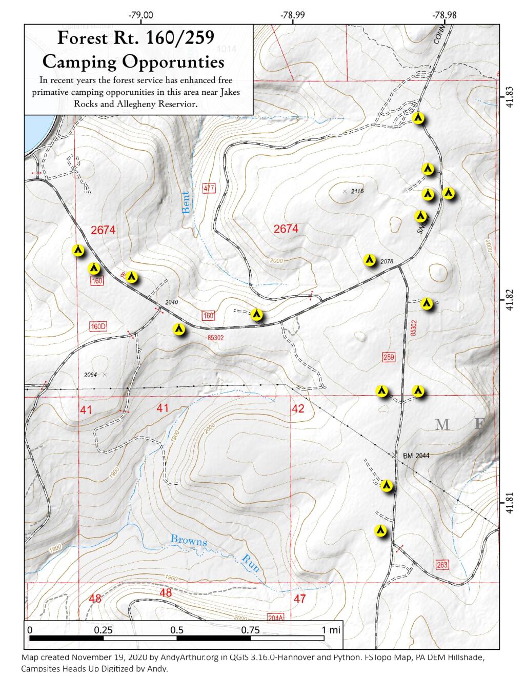
Forest Route 160 And 259 Camping Opporunity
While camping is not allowed at Jakes Rocks, numerous primative campsites exist not all that far from the Jakes Rock trails.
While camping is not allowed at Jakes Rocks, numerous primative campsites exist not all that far from the Jakes Rock trails.
Looking for state land to wheel on? This list shows all of the conservation department-maintained DEC truck trails and public access roads that are more then a 1/2 mile long. This roads are varied, but most of them are dirt roads that take you through the back country. Town maintained roads through state forests are generally not shown on in this listing.
| State Land | Road | Miles |
|---|---|---|
| Albert J. Woodford Memorial State Forest | Truck Trail | 0.7 |
| Albert J. Woodford Memorial State Forest | Janis Road | 1.1 |
| Aldrich Pond Wild Forest | Powell Road | 0.5 |
| Aldrich Pond Wild Forest | Mullins Flow Road | 0.6 |
| Aldrich Pond Wild Forest | Little River Road | 0.7 |
| Aldrich Pond Wild Forest | Silver Dawn Road | 0.7 |
| Aldrich Pond Wild Forest | Jackworks Trail | 1.1 |
| Aldrich Pond Wild Forest | South Creek Lake Road | 1.6 |
| Aldrich Pond Wild Forest | Tyler Road | 3.7 |
| Aldrich Pond Wild Forest | Streeter Lake Road | 4.8 |
| Allen Lake State Forest | George Forest Road | 1.5 |
| Ambler State Forest | Truck Trail | 1.8 |
| Ampersand Primitive Area | Ampersand Park Road | 3.2 |
| Andersen Hill State Forest | Big Pine Public Forest Acess Road | 1.5 |
| Arctic China State Forest | China Public Forest Access Road | 1.1 |
| Arctic China State Forest | Shears Public Forest Access Road | 2 |
| Arctic China State Forest | Dunbar Public Forest Access Road | 2.1 |
| Armlin Hill State Forest | Truck Trail | 1.1 |
| Arnold Lake State Forest | Public Forest Access Road | 0.9 |
| Arnold Lake State Forest | Hartwick Forest Access Road | 1 |
| Ashland Pinnacle State Forest | Ashland Pinnacle Access Road #2 | 0.5 |
| Ashland Pinnacle State Forest | Haul Road #1/Long Path Hiking Trail | 1.4 |
| Avon Regional Office | Goodlake Year Entrance Road | 0.7 |
| Baker School House State Forest | Baker School House Public Forest Acess Road | 1.8 |
| Bald Mountain State Forest | Howe Forest Road | 2.4 |
| Balsam Creek State Forest | Briar Hill Road | 1.5 |
| Barbour Brook State Forest | Barbour Brook Public Forest Access Road | 2 |
| Basswood State Forest | Burlington Public Forest Access Road | 0.5 |
| Basswood State Forest | Basswood Pond Public Forest Access Road | 1 |
| Basswood State Forest | Dr. Crouch Truck Trail | 1.3 |
| Bates State Forest | Pucker Street | 1 |
| Bates State Forest | Bates Forest Road | 2.6 |
| Battle Hill State Forest | Unnamed | 1.3 |
| Bear Pond Primitive Area | Bear Pond Road | 0.8 |
| Bear Swamp State Forest | Karsch Haul Road | 0.5 |
| Bear Swamp State Forest | Joe Chamberlin Public Forest Access Road | 1.6 |
| Bear Swamp State Forest | Roseboom Public Facility Truck Trail | 1.8 |
| Bear Swamp State Forest | Snowmobile Trail | 8.3 |
| Bearpen Mountain State Forest | Ski Run Road | 2.1 |
| Beartown State Forest | Town Road | 0.7 |
| Beartown State Forest | Cotton Road | 0.8 |
| Beartown State Forest | Steam Mill Road | 0.8 |
| Beartown State Forest | Aspen Hollow Road | 2.4 |
| Beaver Creek State Forest | Public Forest Access Road 2, Madison 11 | 0.5 |
| Beaver Creek State Forest | Truck Trail -2-12 | 0.7 |
| Beaver Creek State Forest | Public Forest Access Road 1, Madison 11 | 1.3 |
| Beaver Creek State Forest | Truck Trail -1-12 | 3.6 |
| Beaver Dam State Forest | Sears Public Forest Acess Road | 1.4 |
| Beaver Meadow State Forest | Weir Dam Truck Trail | 0.5 |
| Beebe Hill State Forest | Barrett Pond Road | 1.4 |
| Beebe Hill State Forest | Loop Road | 2.3 |
| Big Brook State Forest | County Line Road Spur | 0.6 |
| Big Brook State Forest | Walasek Mulcoy Road | 0.8 |
| Big Brook State Forest | Hanifin Road | 0.9 |
| Big Brook State Forest | County Line Road | 1.4 |
| Birdseye Hollow State Forest | Sanford Lake Access Road | 0.5 |
| Black Creek State Forest | Stanley Road | 1.1 |
| Black River Wild Forest | Remsen Falls Trail | 0.5 |
| Black River Wild Forest | Woods Lake Road | 0.5 |
| Black River Wild Forest | Gull Lake Road | 0.6 |
| Black River Wild Forest | Flansburg Road | 0.7 |
| Black River Wild Forest | Party Road | 0.7 |
| Black River Wild Forest | Black Creek Road | 0.8 |
| Black River Wild Forest | Cohen Road | 1.7 |
| Black River Wild Forest | Flansberg Road | 2.6 |
| Black River Wild Forest | Black Creek Lake Road | 3 |
| Black River Wild Forest | Haskell Road | 3 |
| Black River Wild Forest | Mill Creek Road | 3.4 |
| Black River Wild Forest | Nicks Lake Campground Roads | 3.5 |
| Black River Wild Forest | Wolf Lake Landing Road | 4.8 |
| Black River Wild Forest | West Creek Road | 6.3 |
| Blenheim Hill State Forest | Ward Allen Road | 1.1 |
| Blenheim Hill State Forest | Quarry Road | 1.2 |
| Blue Mountain Wild Forest | Deer Pond Road | 1.1 |
| Blue Mountain Wild Forest | Chain Lakes Road North | 1.3 |
| Blue Mountain Wild Forest | Polaris Road | 1.3 |
| Bombay State Forest | Cross Haul Road | 0.7 |
| Bombay State Forest | Railroad Bed Public Forest Acess Road | 1.2 |
| Bombay State Forest | Pike Brook Haul Road | 3.1 |
| Bonaparte’s Cave State Forest | Corbine Road | 0.8 |
| Bonaparte’s Cave State Forest | Mud Pond Road | 0.8 |
| Boutwell Hill State Forest | Arab Hill Forest Road, Cha 1 Section | 0.8 |
| Boutwell Hill State Forest | Arab Hill Forest Road, Cha 7 Section | 2.1 |
| Boyce Hill State Forest | Jackson Forest Road | 0.6 |
| Brasher State Forest | Route 53 Haul Road | 0.5 |
| Brasher State Forest | Beaver Pond Trail | 0.6 |
| Brasher State Forest | Kennehan Haul Road | 0.8 |
| Brasher State Forest | Bush Road | 1.1 |
| Brasher State Forest | Buckley Haul Road | 1.2 |
| Brasher State Forest | Cc Dam Public Forest Access Road | 1.2 |
| Brasher State Forest | Mccarthy Public Forest Access Road | 1.6 |
| Brasher State Forest | Liberty Public Forest Access Road | 1.7 |
| Brasher State Forest | Hastings Falls Haul Road | 2.1 |
| Brasher State Forest | Wilson Public Forest Access Road | 2.1 |
| Brasher State Forest | Camp / Larue Public Forest Access Road | 2.2 |
| Brasher State Forest | Pascal Haul Road | 2.4 |
| Brasher State Forest | Bush Public Forest Access Road | 2.9 |
| Brasher State Forest | Railroad Bed Public Forest Access Road | 3.6 |
| Brokenstraw State Forest | Brokenstraw Forest Road | 1.7 |
| Bryant Hill State Forest | Hawk Forest Road | 1.4 |
| Buck Hill State Forest | Hertz Road | 0.7 |
| Buck Hill State Forest | Truck Trail | 1.5 |
| Buck Hill State Forest | Buck Hill Road | 3.1 |
| Bucks Brook State Forest | Access Trail | 0.6 |
| Buckton State Forest | Buckton Haul Road | 0.8 |
| Bucktooth State Forest | Baily Hollow Forest Road | 0.6 |
| Bucktooth State Forest | Manley Hill Forest Road | 1 |
| Bully Hill State Forest | Dixon Forest Road | 1 |
| Bully Hill State Forest | Connection Forest Road | 1.6 |
| Bully Hill State Forest | Stearns Forest Road | 2.1 |
| Burnt-Rossman Hills State Forest | Koenig Road | 0.5 |
| Burnt-Rossman Hills State Forest | Betty Brook Haul Road | 0.6 |
| Burnt-Rossman Hills State Forest | Eminence Dead End Truck Trail | 0.7 |
| Burnt-Rossman Hills State Forest | Duck Pond Road | 1.2 |
| Burnt-Rossman Hills State Forest | Monkey Run Truck Trail East | 1.3 |
| Burnt-Rossman Hills State Forest | Yankee Street Truck Trail | 1.3 |
| Burnt-Rossman Hills State Forest | Betty Brook Road | 1.4 |
| Burnt-Rossman Hills State Forest | Betty Brook Truck Trail | 1.5 |
| Burnt-Rossman Hills State Forest | Duck Pond Truck Trail | 1.5 |
| Burnt-Rossman Hills State Forest | Morey Road Truck Trail | 1.7 |
| Burnt-Rossman Hills State Forest | Eminence Road Truck Trail | 2.6 |
| Burnt-Rossman Hills State Forest | Burnt Hill Road | 2.9 |
| Bush Hill State Forest | Fox Cross Forest Road | 2 |
| California Hill State Forest | Wayawanda Road | 0.7 |
| Canacadea State Forest | Macduff Road | 2.3 |
| Canadaway Creek Wma | Dibble Hill Forest Road | 2 |
| Canaseraga State Forest | Ringelberg Truck Trail | 0.5 |
| Canaseraga State Forest | Right Fork Truck Trail | 1 |
| Canaseraga State Forest | Stanley Road | 1.1 |
| Canaseraga State Forest | Left Fork Truck Trail | 1.4 |
| Caroga Lake Campground | Campground Road | 2 |
| Catherineville State Forest | Santamont Access Trail | 1.1 |
| Catherineville State Forest | Circle Public Forest Access Road | 1.8 |
| Charles E. Baker State Forest | Truck Trail 5 | 0.6 |
| Charles E. Baker State Forest | Truck Trail 2 | 0.9 |
| Charles E. Baker State Forest | Truck Trail 6 | 0.9 |
| Charles E. Baker State Forest | Truck Trail 4 | 1.4 |
| Charles E. Baker State Forest | Truck Trail 12 | 1.5 |
| Charles E. Baker State Forest | Truck Trail 8 | 1.9 |
| Charles E. Baker State Forest | Truck Trail 7 | 2.1 |
| Charles E. Baker State Forest | Truck Trail 1 | 3 |
| Charles E. Baker State Forest | Truck Trail 13 | 3.2 |
| Chazy Highlands State Forest | Spring Road | 0.6 |
| Cherry Valley State Forest | Kniskern Public Access Road | 1.2 |
| Cherry Valley State Forest | Mosse Public Forest Access Road | 1.9 |
| Cinnamon Lake State Forest | Hornby Road Haul Road | 0.7 |
| Clapper Hollow State Forest | Clapper Hollow Truck Trail | 1 |
| Clark Hill State Forest | Abandoned Town Road | 0.8 |
| Clark Hill State Forest | Truck Trail | 0.9 |
| Clark Hill State Forest | Access Road North Of Buck Hill Road | 0.9 |
| Clark Hill State Forest | Class A Truck Trail | 1.2 |
| Clark Hill State Forest | Haul Road | 1.3 |
| Cliffside State Forest | Railroad Haul Road | 1.3 |
| Cobb Brook State Forest | Unnamed Truck Trail | 0.6 |
| Cold Creek State Forest | Headwaters Forest Road | 1.4 |
| Cold Spring Brook State Forest | Cold Spring Brook Public Forest Access Road | 1.9 |
| Cole Hill State Forest | Cr 2 Access Road | 0.8 |
| Coyle Hill State Forest | Warner Spur Forest Road | 0.5 |
| Coyle Hill State Forest | Slawson Forest Road | 0.8 |
| Coyle Hill State Forest | Warner Forest Road | 1.8 |
| Cranberry Lake Campground | Campground Road | 2.5 |
| Cranberry Lake Wild Forest | Grass River Railroad | 6.1 |
| Cuyler Hill State Forest | Jipson Hill Public Forest Acess Road | 1.3 |
| Cuyler Hill State Forest | Cuyler Hill Public Forest Acess Road | 5.1 |
| David A. Sarnoff Preserve | Field Access Road | 0.8 |
| Debar Mountain Wild Forest | Debar Game Refuge Road | 0.5 |
| Debar Mountain Wild Forest | Debar Meadow Road | 0.6 |
| Debar Mountain Wild Forest | Vanderwalker Road | 0.9 |
| Debar Mountain Wild Forest | 4 Mile Road Riffle Season Access Corridor | 1.1 |
| Debar Mountain Wild Forest | Ny Centrail Railroad Bed | 2.2 |
| Deer River State Forest | Ccc Road | 0.6 |
| Deer River State Forest | Hogsback Road | 0.6 |
| Deer River State Forest | Willow Road | 0.6 |
| Deer River State Forest | Glaze Road | 0.7 |
| Deer River State Forest | Avery Lot Road | 0.9 |
| Deer River State Forest | Esseltine Hill Road | 0.9 |
| Deer River State Forest | Ricky’s Number Trail | 1 |
| Deer River State Forest | Horse Barn Road | 1.2 |
| Deer River State Forest | Laramie Road | 1.3 |
| Deer River State Forest | Beanville Road | 1.4 |
| Deer River State Forest | Spruce Road | 1.6 |
| Deer River State Forest | Loope Road | 2 |
| Deer River State Forest | Firewood Road | 2.6 |
| Degrasse State Forest | Burns Flats Road | 0.5 |
| Degrasse State Forest | Loop Road | 1.2 |
| Deruyter State Forest | Tromp Road | 1.5 |
| Dobbins Memorial State Forest | Snowmobile Trail | 3.5 |
| Dog Hollow State Forest | Brewer Public Forest Acess Road | 0.9 |
| Downerville State Forest | River Public Forest Access Road | 1 |
| Dry Run State Forest | Wildcat Hollow | 0.8 |
| Dunkin’s Reserve State Forest | Access Road | 3.5 |
| Dutch Settlement State Forest | Haul Road #1 | 0.6 |
| Dutton Ridge State Forest | Dutton Ridge Access Road | 1.5 |
| Earlville State Forest | Mad 2 Forest Access Road | 1.5 |
| East Osceola State Forest | Malloy Brook Road | 1.1 |
| East Otto State Forest | Kriedeman Forest Road | 1.7 |
| Edgewood Oak Brush Plains Preserve | Edgewood Oak Brush Plains Preserve | 0.5 |
| Edgewood Oak Brush Plains Preserve | Unpaved Forest Road | 0.5 |
| Edgewood Oak Brush Plains Preserve | Old Commack Road | 1.6 |
| English Hill State Forest | Ricketts Forest Road | 0.9 |
| Exeter State Forest | Exeter Public Forest Access Road | 1.3 |
| Fairfield State Forest | Jenksville Hill Public Forest Acess Road | 2 |
| Fall Brook State Forest | Gossner Road | 0.6 |
| Fall Brook State Forest | Haul Road To B-45 Wetland | 0.9 |
| Fall Brook State Forest | Access Road From Co. Rt 67A | 1 |
| Fall Brook State Forest | Forest Access Roaad | 1.2 |
| Ferris Lake Wild Forest | Meco Lake Trail | 0.9 |
| Ferris Lake Wild Forest | Sheriff Lake Trail | 0.9 |
| Ferris Lake Wild Forest | Mud Lake Road | 5.5 |
| Fish Creek State Forest | Forward Road | 0.5 |
| Fish Creek State Forest | Trestle Road | 0.6 |
| Fish Creek Wma | State Highway 184 Access Road | 0.9 |
| Five Rivers Education Center | Goose Lane | 0.5 |
| Flat Rock State Forest | Pedobo Road | 0.8 |
| Flat Rock State Forest | Karsch Haul Road | 0.9 |
| Flat Rock State Forest | Ampersand Park Road | 1.9 |
| Florence Hill State Forest | Florence Hill Road | 1.9 |
| Fort Jackson State Forest | Sheldon Public Forest Access Road | 0.5 |
| Frank E. Jadwin Memorial State Forest | Keesler Road | 0.6 |
| Frank E. Jadwin Memorial State Forest | Old Croghan Road | 0.7 |
| Frank E. Jadwin Memorial State Forest | Henry Road | 0.8 |
| Frank E. Jadwin Memorial State Forest | Nelson Road | 0.8 |
| Frank E. Jadwin Memorial State Forest | Wahalula Road | 0.8 |
| Frank E. Jadwin Memorial State Forest | Q- Road | 1.5 |
| Frank E. Jadwin Memorial State Forest | Patchin Road | 1.7 |
| Frank E. Jadwin Memorial State Forest | Blanchard Creek Road | 2.7 |
| Frank E. Jadwin Memorial State Forest | Wisner Road | 2.7 |
| Frank E. Jadwin Memorial State Forest | Judy Cole Road | 2.8 |
| Frank E. Jadwin Memorial State Forest | Loop Road | 3.2 |
| Fulton Chain Wild Forest | Cary Lake Road | 1.8 |
| Furnace Creek State Forest | Miller Road East | 0.7 |
| Furnace Creek State Forest | Powerline Row | 0.7 |
| Furnace Creek State Forest | Sheehan Road | 1.2 |
| Furnace Creek State Forest | B-29 Road | 1.4 |
| Gates Hill State Forest | Coons Den Truck Trail | 0.6 |
| Gates Hill State Forest | Eviann Road | 1.2 |
| Genegantslet State Forest | South Loomis Road | 0.7 |
| Gillies Hill State Forest | Abbey Forest Road | 0.9 |
| Gillies Hill State Forest | Pettit Forest Road | 1.4 |
| Golden Hill State Forest | Firelane Forest Road | 1.6 |
| Goundry Hill State Forest | Guiren Road | 1 |
| Goundry Hill State Forest | Corbett Hollow Access Road | 1.1 |
| Grant Powell State Forest | Huck Berry Road | 2.1 |
| Grass River Wild Forest | Spruce Mountain Road | 0.8 |
| Grass River Wild Forest | Hollywood Road | 2.5 |
| Grass River Wild Forest | Railroad Grade Road | 2.9 |
| Greenwood Creek State Forest | Grass Pond Public Forest Access Road | 0.9 |
| Grigg’s Gulf State Forest | Grigg’s Gulf Public Forest Acess Road | 1.5 |
| Gulf Unique Area | Gulf R.O.W. Road | 0.5 |
| Gulf Unique Area | Old Skid Road | 1.1 |
| Hall Island State Forest | Unnamed Public Forest Acess Road | 0.7 |
| Hammond Hill State Forest | Redman Run Public Forest Acess Road | 1.1 |
| Hammond Hill State Forest | Cannan Public Forest Acess Road | 1.3 |
| Hammond Pond Wild Forest | Paynes Way | 0.7 |
| Harris Hill State Forest | Sprague Forest Road | 0.8 |
| Harvey Mountain State Forest | Harvey Mt Access Road | 0.9 |
| Harvey Mountain State Forest | East Hill Access Road | 2.4 |
| Hatch Creek State Forest | Hodge Forest Road | 0.6 |
| Hatch Creek State Forest | North Forest Road | 0.8 |
| Hatch Creek State Forest | South Forest Road | 0.9 |
| Hemlock-Canadice State Forest | South Hemlock Access Road | 0.7 |
| Henderson Shores Unique Area | Radar Road | 0.8 |
| Hewitt State Forest | Hewitt Rd | 1.1 |
| Hickok Brook Multiple Use Area | Spur Road | 0.7 |
| Hickok Brook Multiple Use Area | Main Road | 1.1 |
| High Flats State Forest | Chapel Hill Access Trail | 0.5 |
| High Flats State Forest | Crowley Access Trail | 0.5 |
| High Flats State Forest | Close Pond Access Trail | 0.7 |
| High Flats State Forest | Donovan Public Forest Access Road | 1.1 |
| High Knob State Forest | Shale Pit Road | 1.9 |
| High Peaks Wilderness | Northville-Placid Trail-Northern Terminus | 1.1 |
| Hill Higher State Forest | Hill Higher Forest Road | 1.1 |
| Hinckley State Forest | Elm Flats Road | 0.5 |
| Hinckley State Forest | Roberts Road | 0.5 |
| Hinckley State Forest | Lanning Road | 0.8 |
| Hinckley State Forest | Access Road | 1.6 |
| Hinckley State Forest | Black Creek Road | 2 |
| Hogsback State Forest | Forest Access Road | 3 |
| Honey Hill State Forest | Edwards Public Forest Access Road | 1.4 |
| Hooker Mountain State Forest | Norton Public Forest Access Road | 0.8 |
| Horseshoe Lake Wild Forest | Cut Off Road | 0.6 |
| Horseshoe Lake Wild Forest | Lower Dam Road | 0.7 |
| Horseshoe Lake Wild Forest | Otter Brook Trail | 0.9 |
| Horseshoe Lake Wild Forest | Grass River Railroad | 1.7 |
| Horseshoe Lake Wild Forest | Otter Brook Road | 2.2 |
| Hoxie Gorge State Forest | Russel Hill Public Forest Acess Road | 2.5 |
| Huntersfield State Forest | Huntersfield Access Road #2 | 0.7 |
| Huntersfield State Forest | Huntersfield Access Road #1 | 1.9 |
| Hunts Pond State Forest | Truck Trail | 1.7 |
| Independence River State Forest | Assembly Road | 1 |
| Independence River Wild Forest | Blue Jog Road | 0.5 |
| Independence River Wild Forest | Sunday Lake Road | 0.5 |
| Independence River Wild Forest | Evies Pond Road | 0.7 |
| Independence River Wild Forest | Burnt Creek Road | 0.7 |
| Independence River Wild Forest | Elbow Rd | 0.7 |
| Independence River Wild Forest | Shortcut Road | 0.8 |
| Independence River Wild Forest | Fish Pond Road | 1 |
| Independence River Wild Forest | Halfmoon Lake Rd | 1 |
| Independence River Wild Forest | Little Otter Creek Road | 1 |
| Independence River Wild Forest | Long Pond Spur | 1 |
| Independence River Wild Forest | East Loop Road | 1.1 |
| Independence River Wild Forest | Copper Lake Road | 1.2 |
| Independence River Wild Forest | Necessary Dam Road | 1.2 |
| Independence River Wild Forest | Pitcher Pond Road | 1.3 |
| Independence River Wild Forest | Hinchings Pond Road | 1.8 |
| Independence River Wild Forest | Basket Factory Road | 2.1 |
| Independence River Wild Forest | Catspaw Lake Road | 2.4 |
| Independence River Wild Forest | Confusion Flats Road | 2.6 |
| Independence River Wild Forest | Big Otter Lake Road | 3.1 |
| Independence River Wild Forest | Stony Lake Road | 3.1 |
| Independence River Wild Forest | Florence Pond Road | 3.1 |
| Independence River Wild Forest | Steam Mill Road | 3.5 |
| Independence River Wild Forest | Smith Road | 3.7 |
| Indian Pipe State Forest | Dunes Road | 0.7 |
| Indian River Wma | Red Lake Road | 2 |
| Jackson Hill State Forest | Forest Access Road | 2.1 |
| Jersey Hill State Forest | Scholes Forest Road | 1.6 |
| Jessup River Wild Forest | Lake Colby Camp Road | 0.7 |
| Karr Valley Creek State Forest | Frungillo Forest Road | 0.8 |
| Karr Valley Creek State Forest | Norton Forest Road | 1.3 |
| Karr Valley Creek State Forest | Davison Forest Road | 1.4 |
| Keeney Swamp State Forest | Fitch Hill Spur Forest Road | 0.7 |
| Keeney Swamp State Forest | C3D | 0.8 |
| Keeney Swamp State Forest | Fitch Hill Forest Road | 1.2 |
| Keeney Swamp State Forest | Gordon Forest Road | 1.4 |
| Kennedy State Forest | Courtney Hill Public Forest Acess Road | 0.7 |
| Kennedy State Forest | Cotton-Hanlon Public Forest Acess Road | 1 |
| Kennedy State Forest | Kennedy Public Forest Acess Road | 2.5 |
| Kenneth Wilson Campground | Campground Road | 9.7 |
| Ketchumville State Forest | Ketchumville Public Forest Acess Road | 1 |
| Keyserkill State Forest | Guinea Road Truck Trail | 1 |
| Keyserkill State Forest | Keyserkill Truck Trail #1 | 1.3 |
| Klipnocky State Forest | Emery Forest Road | 1.2 |
| Klipnocky State Forest | Marble Forest Road | 1.6 |
| Klondike State Forest | Klondike Public Forest Acess Road | 1.7 |
| Lafayetteville Multiple Use Area | Wilbur Flats Road | 0.9 |
| Lake Durant Campground | Scott Public Forest Acess Road | 0.9 |
| Lake George Wild Forest | Jabe Pond Road | 1 |
| Lake George Wild Forest | Dacy Clearing Road | 1.6 |
| Lake George Wild Forest | Lily Pond Road | 2.1 |
| Lake George Wild Forest | Gay Pond Road | 4 |
| Lake Harris Campground | Campground Road | 0.9 |
| Lakeview Marsh Wma | Skinner Road | 0.7 |
| Leonard Hill State Forest | Leonard Hill Access Road #1 | 0.7 |
| Leonard Hill State Forest | Leonard Hill Access Road #3 | 1.2 |
| Leonard Hill State Forest | Leonard Hill Access Road #2 | 1.6 |
| Lesser Wilderness State Forest | Gomer Hill Road | 0.5 |
| Lesser Wilderness State Forest | Toole Road | 0.6 |
| Lesser Wilderness State Forest | Alguire Road | 0.7 |
| Lesser Wilderness State Forest | Smith Road | 0.8 |
| Lesser Wilderness State Forest | Nob Road | 0.9 |
| Lesser Wilderness State Forest | Seelman Road | 1.3 |
| Lesser Wilderness State Forest | Mcgoldrick Road | 3 |
| Lesser Wilderness State Forest | #9 Road | 4.7 |
| Limekiln Lake Campground | Lime Kiln Lake Campground Trails | 3.9 |
| Linda Gronlund Memorial At Barcelona Neck | Trustee Road West | 1 |
| Linda Gronlund Memorial At Barcelona Neck | Trustee Road East | 1.7 |
| Lonesome Bay State Forest | Alamogin Public Forest Access Road | 2.2 |
| Long Pond State Forest | Access Road | 0.5 |
| Long Pond State Forest | Truck Trail | 0.7 |
| Long Pond State Forest | Long Pond Snowmobile Trail | 0.8 |
| Lookout State Forest | Ball Road | 0.6 |
| Lost Nation State Forest | Brookdale Road / Jenkins Corners Rd / Red Barn Rd | 2.5 |
| Lost Valley State Forest | Lost Valley Haul Road | 1.2 |
| Lowville Demonstration Area | Dadville Road | 0.6 |
| Ludlow Creek State Forest | Trail Road | 1.3 |
| Lutheranville State Forest | Access Road #1 | 0.5 |
| Lutheranville State Forest | Access Road #2 | 1.2 |
| Lyon Brook State Forest | Lyon Brook Truck Trail | 1.2 |
| Mad River State Forest | Thompson Corners Florence Road | 0.5 |
| Mad River State Forest | Bartlett Road | 0.6 |
| Mad River State Forest | Rehm Road | 0.6 |
| Mad River State Forest | Phalen Road South | 1.9 |
| Mad River State Forest | Mcspirit Road | 2.1 |
| Madawaska Flow – Quebec Brook Primitive Area | Benz Pond Road | 2.2 |
| Mallet Pond State Forest | Cemetery Road Truck Trail | 2 |
| Maxon Creek State Forest | Pease Hill Public Forest Acess Road | 1 |
| Mccarthy Hill State Forest | Main Access Road | 0.5 |
| Mccarty Hill State Forest | Ccc Forest Road | 1.5 |
| Mccarty Hill State Forest | Mccarty Hill East Forest Road | 2 |
| Mcdonough State Forest | Ccc Trail | 1 |
| Mcdonough State Forest | Truck Trail 4 | 1.1 |
| Mcdonough State Forest | Finger Lakes Trail | 1.8 |
| Mcdonough State Forest | Truck Trail 3 | 2 |
| Melondy Hill State Forest | Public Forest Access Road | 2.5 |
| Montrose Point State Forest | Through Trail | 0.6 |
| Moose River Plains Wild Forest | Loop Road | 1.2 |
| Moose River Plains Wild Forest | Indian Lake Road | 3.4 |
| Moose River Plains Wild Forest | Otter Brook Road | 3.4 |
| Moose River Plains Wild Forest | Rock Dam Road | 4.2 |
| Moose River Plains Wild Forest | Lime Kiln Lake – Cedar River Road | 16.9 |
| Morgan Hill State Forest | Herlihy Haul Road | 0.6 |
| Morgan Hill State Forest | Keith Gutchess Haul Road | 0.7 |
| Morrow Mountain State Forest | Mollie Road | 2.8 |
| Mount Hunger State Forest | Whalen Road | 0.6 |
| Mount Pisgah State Forest | Mt Pisgah Access Road #1 | 1.3 |
| Mount Pleasant State Forest | Beck Forest Road | 0.6 |
| Mount Pleasant State Forest | Brumagin Forest Road | 0.7 |
| Mount Pleasant State Forest | Spruce Forest Road | 0.8 |
| Mount Tom State Forest | Notch Lane Access Road | 1.4 |
| Mount Tom State Forest | Shaker Hollow Access Trail | 1.4 |
| Muller Hill State Forest | Davenport Road | 1.4 |
| Muller Hill State Forest | Bliss Road | 1.5 |
| New Forge State Forest | New Forge Access Road #2 | 0.5 |
| New Forge State Forest | New Forge Access Road #3 | 0.6 |
| New Forge State Forest | New Forge Access Road | 1.5 |
| Newfield State Forest | Irish Hill Haul Road | 0.8 |
| Nicks Lake Campground | Nicks Lake Campground Roads | 0.6 |
| Nimham Mountain Multiple Use Area | Coles Mills Road | 0.7 |
| Nimham Mountain Multiple Use Area | Tower Road | 0.7 |
| Nine Mile Creek State Forest | North Nine Mile Town Road | 0.5 |
| Nine Mile Creek State Forest | Phearsdorf Forest Road | 0.5 |
| Nine Mile Creek State Forest | North Nine Mile Forest Road | 2.2 |
| North Harmony State Forest | Snake Forest Road | 0.9 |
| North South Lake Campground | South Lake Road | 1.3 |
| North South Lake Campground | North Lake Campground Road | 1.8 |
| Northhampton Beach Campground | Campground Road | 5.5 |
| Oakley Corners State Forest | Oakley Corners North Public Forest Acess Road | 1.6 |
| Ohissa State Forest | Cramers Corner Road | 0.8 |
| Onjebonge State Forest | Lime Quarry Road | 1.3 |
| Onjebonge State Forest | Alice Coffey Road | 2.5 |
| Orebed Creek State Forest | Ritz Road | 1.3 |
| Ossian State Forest | Back Road To Rattlesnake | 0.7 |
| Ossian State Forest | Scoville Access Road | 1 |
| Ossian State Forest | Linzy Road Truck Trail | 1.8 |
| Otselic State Forest | Truck Trail | 3.1 |
| Otsquago State Forest | Wagner Hill Road | 0.8 |
| Otter Creek State Forest | Eatonville Road | 0.6 |
| Otter Creek State Forest | Mikes Road | 1.2 |
| Otter Creek State Forest | Otter Creek Road | 1.5 |
| Palmer’s Pond State Forest | Geitner Forest Road | 0.7 |
| Palmer’s Pond State Forest | Palmer’s Pond Forest Road | 1.5 |
| Palmer’s Pond State Forest | 6 | 2.4 |
| Partridge Run Wma | Boys Camp Road Ext | 2 |
| Patria State Forest | Pleasant Valley Road | 0.6 |
| Patria State Forest | Barkman Road Access | 0.6 |
| Patria State Forest | Hardscrabble Road Access | 0.8 |
| Peck Hill State Forest | Swamp Road | 0.5 |
| Peck Hill State Forest | West Boundary Trail | 0.6 |
| Peck Hill State Forest | Beaver Vly | 0.7 |
| Peck Hill State Forest | Dam Road | 0.7 |
| Penn Mountain State Forest | Star Hill Road | 1 |
| Penn Mountain State Forest | West Gate Road | 2.6 |
| Penn Mountain State Forest | South Gate Road | 3.6 |
| Penn Mountain State Forest | East Gate Road | 3.8 |
| Perch River Wma | Perch Lake Road | 0.5 |
| Perch River Wma | Buckminster Road | 0.9 |
| Perch River Wma | Cook Road | 1.4 |
| Perch River Wma | Allen Road | 2.1 |
| Perch River Wma | State Route 12 | 2.6 |
| Perch River Wma | Vaadi Road | 3 |
| Perch River Wma | Dog Hill Road | 4 |
| Pharsalia Woods State Forest | Nine Mile Truck Trail Snowmobile Trail | 1.6 |
| Piermont Marsh Tidal Wetland | Piermont Pier Access Road | 0.9 |
| Pine Hill State Forest | Bundy Hollow Public Forest Access Road | 1 |
| Pittstown State Forest | State Fire Lane | 2.2 |
| Plainfield State Forest | Hughes Public Forest Access Road | 1.3 |
| Plattekill State Forest | Mountain Brook Road | 1 |
| Plumbottom State Forest | Reddy Forest Road | 3 |
| Point Peninsula Wma | Pine Woods Road | 1.5 |
| Point Peninsula Wma | Beach Road | 2.1 |
| Point Peninsula Wma | Shore Road | 8 |
| Point Rock State Forest | Egger Brrok Raod | 1.3 |
| Popple Pond State Forest | Smith Road | 0.7 |
| Popple Pond State Forest | Haul Road Shared By Oneida 6 And County Forest | 1.6 |
| Popple Pond State Forest | Truck Trail | 3 |
| Potato Hill State Forest | Blackman Hill Rd | 1.1 |
| Potato Hill State Forest | Level Green Rd | 1.2 |
| Pulpit Rock State Forest | Watson Road | 0.6 |
| Punkeyville State Forest | Irish Settlement Road | 0.7 |
| Punkeyville State Forest | River Road | 0.9 |
| R Milton Hick Memorial State Forest | Lafleuer Road | 1.2 |
| Relay State Forest | Relay Public Forest Access Road | 1.2 |
| Rensselaerville State Forest | Kenyon Road Access | 2.4 |
| Ridge Conservation Area And Maintenance Center | Mid-Island Access Road | 0.5 |
| Rock City State Forest | Salamanca Forest Road | 0.8 |
| Rock City State Forest | Eckert Forest Road | 0.9 |
| Rock City State Forest | Little Rock City Forest Road | 2 |
| Rock Creek State Forest | Admin Access Road | 1.3 |
| Rockwood State Forest | Spring Road | 0.5 |
| Rockwood State Forest | B Road | 0.6 |
| Rocky Point Pine Barrens State Forest | Accessible | 0.5 |
| Rocky Point Pine Barrens State Forest | Firestone Road | 1.7 |
| Rural Grove State Forest | Rural Grove Access Road (Shibley Road) | 3.1 |
| Rush Creek State Forest | C2-C | 1.2 |
| Rush Creek State Forest | Russell Forest Road | 3 |
| Sacandaga Campground | Sacandaga Campground | 1.4 |
| Salmon River State Forest | Harpers Ferry Public Forest Acess Road | 0.9 |
| Sand Flats State Forest | Bucks Corners Road | 0.9 |
| Sand Flats State Forest | Obrian Road | 0.9 |
| Sand Flats State Forest | Water Hole Road | 1 |
| Sand Flats State Forest | Y Road | 1.5 |
| Sand Flats State Forest | Powell Road | 1.7 |
| Sand Flats State Forest | Fall Brook Road | 2.2 |
| Saranac Lakes Wild Forest | Horseshoe Pond Trail | 0.5 |
| Saranac Lakes Wild Forest | Little Clear Pond Road | 0.5 |
| Saranac Lakes Wild Forest | Connery Pond Road | 0.6 |
| Saranac Lakes Wild Forest | Little Green Pond Road | 0.6 |
| Saranac Lakes Wild Forest | Rollins Pond Access Road | 0.8 |
| Saranac Lakes Wild Forest | Medow Pond Truck Trail | 0.9 |
| Saranac Lakes Wild Forest | Bartlett Carry Road | 1.2 |
| Saranac Lakes Wild Forest | Floodwood Mountain Road | 1.2 |
| Saranac Lakes Wild Forest | Rat Pond Road | 1.5 |
| Saranac Lakes Wild Forest | Sunday Pond Road | 1.6 |
| Scott Patent State Forest | Scott Patent Access Road | 1.4 |
| Shawangunk Ridge State Forest | Woods Road | 1 |
| Shindagin Hollow State Forest | Ekroos Public Forest Acess Road | 1.4 |
| Skyline Drive State Forest | Skyline Drive Public Forest Acess Road | 2.2 |
| Slader Creek State Forest | Oberdorf Forest Road | 2.1 |
| Sonyea State Forest | Shaker Access Road | 1.9 |
| South Bradford State Forest | Ccc Road | 1.6 |
| South Hill State Forest | South Hill Truck Trail | 0.5 |
| South Hill State Forest | Public Forest Access Road Extension | 0.9 |
| South Hill State Forest | South Hill Public Forest Access Road | 0.9 |
| South Hill State Forest | Kotary Road Extension | 1 |
| South Hill State Forest | Powerline Road | 1 |
| South Mountain State Forest | Ashland Pinnacle Access Road #2 | 0.5 |
| South Mountain State Forest | South Mountain Access Road | 0.9 |
| South Mountain State Forest | Bluebird Road | 1.1 |
| South Valley State Forest | Phillips Brook Fr First Section | 0.7 |
| South Valley State Forest | Phillips Brook Forest Road | 1.2 |
| St. Regis River State Forest | Old Railroad Bed | 1.6 |
| Stammer Creek State Forest | Sugar Bush Haul Road | 1.1 |
| Steam Mill State Forest | Zion Public Forest Access Road #2 | 0.5 |
| Steam Mill State Forest | Glass House Hill Road | 1 |
| Steam Mill State Forest | Assembly Road | 1.1 |
| Steam Mill State Forest | Steammill Rd | 1.4 |
| Steam Mill State Forest | Carroll Hill Public Forest Access Road #2 | 1.9 |
| Steam Mill State Forest | Zion Public Forest Access Road #1 | 2 |
| Steam Mill State Forest | Carroll Hill Public Forest Access Road #3 | 2.5 |
| Stewart State Forest | Great Swamp Road | 0.5 |
| Stewart State Forest | Drakes Ln | 0.6 |
| Stewart State Forest | Orlando Dr | 0.6 |
| Stewart State Forest | Ridge Road South | 0.6 |
| Stewart State Forest | Scofield Lane | 0.7 |
| Stewart State Forest | Armstrong Lane Trail | 0.9 |
| Stewart State Forest | Giles Road | 0.9 |
| Stewart State Forest | Pittman Robertson Pond Road | 0.9 |
| Stewart State Forest | Weed Road | 1.2 |
| Stewart State Forest | Beaver Pond Road | 1.3 |
| Stewart State Forest | Barron Road | 1.8 |
| Stewart State Forest | Barron Road South 208 | 1.8 |
| Stewart State Forest | Ridge Road | 2.8 |
| Stewart State Forest | Maple Ave | 3.1 |
| Stewart State Forest | New Road | 3.4 |
| Stockton State Forest | Blackman Forest Road | 1.4 |
| Stone Store State Forest | Fawn Ridge Road | 2.7 |
| Sugar Hill State Forest | Firetower Access Road | 0.5 |
| Sugar Hill State Forest | Old Westerfield Road | 0.5 |
| Sugar Hill State Forest | A Trail | 1 |
| Sugar Hill State Forest | Pine Knob Road | 1 |
| Sugar Hill State Forest | Maple Lane | 2.1 |
| Summer Hill State Forest | Snowmobile Trail | 5 |
| Sundown Wild Forest | South Mountain Extension | 1 |
| Swancott Hill State Forest | Tower Road | 2.3 |
| Swancott Mill State Forest | Swancott Mill Road | 0.9 |
| Taconic Hereford Multiple Use Area | Pirate Crrek | 0.5 |
| Taconic Hereford Multiple Use Area | Whatchamacallit | 0.5 |
| Taconic Hereford Multiple Use Area | Camp | 0.6 |
| Taconic Hereford Multiple Use Area | Mercury | 0.6 |
| Taconic Hereford Multiple Use Area | Border Trail | 0.8 |
| Taconic Hereford Multiple Use Area | Mustang | 0.8 |
| Taconic Hereford Multiple Use Area | Outer Gut | 0.8 |
| Taconic Hereford Multiple Use Area | Brockway Road | 0.9 |
| Taconic Hereford Multiple Use Area | Green Acres | 1.2 |
| Taconic Hereford Multiple Use Area | Tsp Road | 1.2 |
| Taconic Hereford Multiple Use Area | Pond Gut Road | 1.3 |
| Taconic Hereford Multiple Use Area | Timbuktu | 1.3 |
| Taconic Hereford Multiple Use Area | Fong’s Way | 1.4 |
| Taconic Hereford Multiple Use Area | Getaway | 1.9 |
| Taconic Hereford Multiple Use Area | Upper Snowmobile Trail | 1.9 |
| Taconic Ridge State Forest | Rounds Mountain Rd. | 0.8 |
| Taconic Ridge State Forest | Robinson’s Hollow Road | 0.9 |
| Taconic Ridge State Forest | Green Hollow Access Road | 1.1 |
| Taylor Creek State Forest | T Road Public Forest Access Road | 1 |
| Taylor Valley State Forest | Seacord Hill Spur Public Forest Acess Road | 0.9 |
| Taylor Valley State Forest | Seacord Hill Public Forest Acess Road | 2.1 |
| Taylor Valley State Forest | Mount Roderick Public Forest Acess Road | 4.3 |
| Terry Mountain State Forest | Lynch Mt Road Trail | 1 |
| Terry Mountain State Forest | Red Road | 1.7 |
| Terry Mountain State Forest | Mud Pond Road Trail | 2 |
| Terry Mountain State Forest | Tower Road | 2 |
| Texas Hill State Forest | M8 Access Trail | 0.6 |
| Texas Hill State Forest | Texas Hill Truck Trail | 0.7 |
| Texas School House State Forest | New Lisbon Public Forest Access Road | 1.2 |
| Three Springs State Forest | Three Springs Access Road | 1.6 |
| Tied Lake Primitive Area | Tied Lake Road | 1.2 |
| Titusville Mountain State Forest | Lee Road | 2 |
| Tomannex State Forest | Tomannex Public Forest Access Road | 1 |
| Tomannex State Forest | Haul Road #1 | 4.7 |
| Toothaker Creek State Forest | Garrison Access Trail | 1.1 |
| Tri-County State Forest | Flanagan Road | 0.5 |
| Trout Lake State Forest | Cedar Lake Public Forest Access Road | 0.5 |
| Tug Hill State Forest | Home Run Road | 0.6 |
| Tug Hill State Forest | Babbit Road | 0.8 |
| Tug Hill State Forest | Gruntley Road | 1.3 |
| Tug Hill State Forest | Mile Strip Road | 2.5 |
| Tug Hill State Forest | Denning (West) Road | 2.8 |
| Tug Hill State Forest | Willams Road | 2.9 |
| Tug Hill State Forest | Horace Forward Road | 3.3 |
| Tug Hill Wma | Alphabet Lane Road | 0.8 |
| Tug Hill Wma | Runing George Road | 1.3 |
| Tug Hill Wma | Beech Street Road | 1.7 |
| Tug Hill Wma | Running George Road | 3.8 |
| Tuller Hill State Forest | Snyder Hill Public Forest Acess Road | 1.6 |
| Tuller Hill State Forest | Pipeline Public Forest Acess Road | 1.6 |
| Tuller Hill State Forest | Vinnedge Public Forest Acess Road | 1.7 |
| Turkey Hill State Forest | Turkey Hill Public Forest Acess Road | 1.3 |
| Turkey Ridge State Forest | Turkey Road | 0.7 |
| Turnpike State Forest | Turnpike Forest Road | 2.2 |
| Turnpike State Forest | Stewart Forest Road | 3.1 |
| Upper And Lower Lakes Wma | Canton Access Road | 0.5 |
| Upper And Lower Lakes Wma | Logging Access Road | 0.5 |
| Upper And Lower Lakes Wma | Corning Access Road | 1 |
| Upper And Lower Lakes Wma | Middle Access Road | 1.2 |
| Vandermark State Forest | Allen Forest Road | 1.1 |
| Vandermark State Forest | Bird Forest Road | 1.5 |
| Vanderwhacker Mountain Wild Forest | Cheney Pond Road | 0.5 |
| Vanderwhacker Mountain Wild Forest | Thilo Road | 1.7 |
| Vanderwhacker Mountain Wild Forest | Vanderwhacker Road | 2.6 |
| Watson’s East Triangle Wild Forest | Wolf Creek Road West | 0.5 |
| Watson’s East Triangle Wild Forest | Deep Cuts Road | 0.6 |
| Watson’s East Triangle Wild Forest | Tunnel Road | 0.7 |
| Watson’s East Triangle Wild Forest | Number 1 Road | 2.1 |
| Watson’s East Triangle Wild Forest | Bear Pond Road | 8.4 |
| Webster Hill State Forest | Webster Hill Forest Access Road | 0.8 |
| West Canada Lake Wilderness | Northville-Placid Trail | 2.2 |
| West Parishville State Forest | Scotch Pine Access Trail | 0.5 |
| West Parishville State Forest | Red Pine Access Trail | 0.7 |
| West Parishville State Forest | Kidney Killer Access Trail | 0.9 |
| Whalen Memorial State Forest | Whalen Forest Road | 1.6 |
| Whaupaunaucau State Forest | Haul Road #4 | 0.5 |
| Whaupaunaucau State Forest | Alguire Road | 1 |
| Whaupaunaucau State Forest | C8 – B15 Road | 1.3 |
| Whippoorwill Corners State Forest | Loop Access Road | 1.3 |
| Whiskey Flats State Forest | Capell Access Road | 0.5 |
| Whiskey Flats State Forest | Sochia Pond Public Forest Access Road | 0.5 |
| Whiskey Flats State Forest | Sandy Public Forest Access Road | 0.7 |
| White Pond Multiple Use Area | Farmers Mills Road | 0.9 |
| White Pond Multiple Use Area | White Pond Road | 1 |
| Wilcox Lake Wild Forest | Dorr Road | 0.5 |
| Wilcox Lake Wild Forest | Lizard Pond Road | 0.6 |
| Wilcox Lake Wild Forest | Mud Pond Road | 0.7 |
| Wilcox Lake Wild Forest | Fish Ponds Road | 0.8 |
| Wilcox Lake Wild Forest | Harrisburg Lake Road | 1.5 |
| Wilcox Lake Wild Forest | Pumpkin Hollow Road | 1.5 |
| Wilcox Lake Wild Forest | Oregon Road | 1.7 |
| Wilcox Lake Wild Forest | West Stony Creek Road | 5.4 |
| Wiley Brook State Forest | Finger Lakes Trail | 0.7 |
| William C. Whitney Wilderness | Lake Lila Road | 5.8 |
| Wilson Hill Wma | Sand Road | 0.6 |
| Wilson Hill Wma | Northern Access Road | 1.9 |
| Winona State Forest | Blood Road | 0.7 |
| Winona State Forest | Hessel Road | 0.9 |
| Winona State Forest | Remington | 1.1 |
| Winona State Forest | Hawley Road | 1.5 |
| Winona State Forest | Tucker Road | 2.6 |
| Winona State Forest | Bargy (Main) Road | 3.2 |
| Wolf Lake State Forest | Orbegezo Row | 1.4 |
| Woodland Valley Campground | Woodland Valley Road | 0.5 |
| Woodland Valley Campground | Camping Trail Road | 0.8 |
| Yatesville Falls State Forest | Yatesville Falls Access Road | 1.2 |
Looking for state land to wheel on? This list shows all of the conservation department-maintained DEC truck trails and public access roads that are more then a 1/2 mile long. This roads are varied, but most of them are dirt roads that take you through the back country. Town maintained roads through state forests are generally not shown on in this listing.
Allegheny National Forest Dispersed Campsites (shown on this map with a round Yellow Camp logo) are free-to-use with a 14-day stay limit in any 30 day period. Many of these campsites are informal areas used for camping, others like along Forest Road 160 and 259 near Jakes Rock;s and along Lolita Grade have enhanced gravel pads/parking areas. Unlike New York State, they do not have formal markings at the sites.
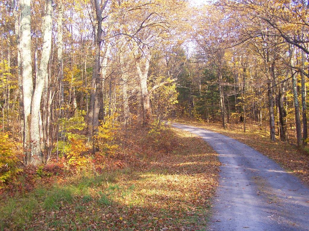
In the Allegheny National Forest there are a variety of back country roads, offering primitive roadside camping.
Updated 5/11/2020 - Additional sites along Loleta Grade shown on this map, this new map separated out from NYS campsite map and includes additional information about developed recreation areas, roads and trails.
Please see also information on dispersed, roadside and back-country camping in New York State, Pennsylvania (including DCNR's free-Motor Vehicle Camping program) and West Virginia.
Link to an Interactive Map of the Northville Placid Trail.
| Type | Name | Description | Coordinates |
| Hand Launch | Ceder River Flow Boat Ramp | Hand Carry Launch, Ramp | 43.725826369700904, -74.47289916126694 |
| Lean-To | Beaver Pond (Aka Cedar Lakes Lean-To #2) | 43.625969396804386, -74.54927150370021 | |
| Lean-To | Carry Lean-To | 43.67874488347091, -74.49549821879448 | |
| Lean-To | Catlin Bay #1 Lean-To | 43.99801269269887, -74.39278456108421 | |
| Lean-To | Cedar Lakes #1 Lean-To | 43.628125665037935, -74.54047323992656 | |
| Lean-To | Cold River #2 Lean-To | 44.14251664317184, -74.13035824291548 | |
| Lean-To | Cold River #3 Lean-To | 44.091459278051204, -74.25764175084498 | |
| Lean-To | Cold River #4 Lean-To | 44.09139025333258, -74.25573480252505 | |
| Lean-To | Cold River Lean-To #1 Lean-To | 44.14272737628489, -74.12984021065587 | |
| Lean-To | Duck Hole #1 Lean-To | 44.14162687400988, -74.10693734676616 | |
| Lean-To | Duck Hole #2 Lean-To | 44.14167686466829, -74.10654354672256 | |
| Lean-To | Hamilton Lake Stream #1 Lean-To | 43.39741359517532, -74.45529759002217 | |
| Lean-To | Hidden Cove Lean-To | 44.00265528819394, -74.38648026325164 | |
| Lean-To | Kelly Point #1 Lean-To | 44.02880023617087, -74.36730798599064 | |
| Lean-To | Kelly Point #2 Lean-To | 44.02870256717196, -74.36713034867948 | |
| Lean-To | Moose Pond Lean-To | 44.182843382402666, -74.07364102375995 | |
| Lean-To | Mud Lake Lean-To | 43.342671073157994, -74.45629078563864 | |
| Lean-To | O’neill Flow Lean-To | 43.875596840936154, -74.36642623697053 | |
| Lean-To | Ouluska Pass Brook Lean-To | 44.120221281603584, -74.18744717390932 | |
| Lean-To | Plumley Point #2 Lean-To | 44.06559891610762, -74.32761224546002 | |
| Lean-To | Rodney Point #1 Lean-To | 44.04140938489936, -74.35014909639557 | |
| Lean-To | Rodney Point #2 Lean-To | 44.042976745412616, -74.34933464753136 | |
| Lean-To | Seward Lean-To | 44.106244137686204, -74.2091536427719 | |
| Lean-To | Silver Lake Lean-To | 43.29193545679836, -74.4237351676776 | |
| Lean-To | South Lake Lean-To | 43.58724480971, -74.62157883837274 | |
| Lean-To | Spruce Lake #1 Lean-To | 43.52728411257782, -74.6099246975027 | |
| Lean-To | Spruce Lake #2 Lean-To | 43.53463062983387, -74.60808580306896 | |
| Lean-To | Spruce Lake #3 Lean-To | 43.53712972792447, -74.60820962802477 | |
| Lean-To | Stephens Pond Lean-To | 43.818673668554965, -74.42052487172707 | |
| Lean-To | Tirrel Pond North Lean-To | 43.887344477557306, -74.37880062606054 | |
| Lean-To | West Canada Creek Lean-To | 43.58698761405157, -74.61399797100106 | |
| Lean-To | West Lake #1 Lean-To | 43.59316222884976, -74.62688668431306 | |
| Lean-To | West Stony Creek Lean-To | 43.22474428954461, -74.26933345717664 | |
| Paved Parking Lot | Lake Durant Northville Placid Trail Parking Lot | Paved, 12 Vehicle Capacity | 43.84219550506574, -74.3862742856788 |
| Paved Parking Lot | Northville Lake Placid Trail Parking Lot | Paved, Good Condition | 43.84213270187873, -74.38656792328511 |
| Primitive Tent Site | Canary Pond Campsite | 43.30513256312245, -74.4472062440692 | |
| Primitive Tent Site | Cedar Lake Dam 1 | 43.62894580965635, -74.53639939387939 | |
| Primitive Tent Site | Cedar Lake Dam Tentsite | 43.62937624507422, -74.53679785644344 | |
| Primitive Tent Site | Cedar River Flow Tentsite | 43.70292480315104, -74.48713041165333 | |
| Primitive Tent Site | Fall Stream Tentsites | 43.49661052800474, -74.53713112743992 | |
| Primitive Tent Site | Jessup River Tentsites | 43.51246207852797, -74.57229710138834 | |
| Primitive Tent Site | Kelly Point Tentsites | 44.02910364406153, -74.36670207204214 | |
| Primitive Tent Site | Moose Pond Tentsites | 44.18274441156179, -74.07408240028583 | |
| Primitive Tent Site | Moose River Plains Campsite 01 | Live | 43.72667672123972, -74.47410026642402 |
| Primitive Tent Site | Moose River Plains Campsite 02 | Live | 43.72665150100841, -74.47331107300782 |
| Primitive Tent Site | Moose River Plains Campsite 03 | Live | 43.725959512295866, -74.47389996564202 |
| Primitive Tent Site | Moose River Plains Campsite 04 | Live | 43.726067692208126, -74.47423264719026 |
| Primitive Tent Site | Moose River Plains Campsite 05 | Live | 43.725563790898704, -74.47417512282912 |
| Primitive Tent Site | Moose River Plains Campsite 06 | Live | 43.72522313374867, -74.47458303719159 |
| Primitive Tent Site | Mud Lake Tentsites | 43.59647433847274, -74.61354076182431 | |
| Primitive Tent Site | O’neill Flow Tentsite | 43.87567135918534, -74.3666467203306 | |
| Primitive Tent Site | Rock Lake Campsite | 43.265591839994535, -74.41543516012669 | |
| Primitive Tent Site | Salmon River Tentsites | 43.907925071619914, -74.38530801916977 | |
| Primitive Tent Site | Shattuck Clearing Tentsites | 44.08679657756681, -74.26368397541134 | |
| Primitive Tent Site | Silver Lake Tent Site | 43.29112770008321, -74.4240469986026 | |
| Primitive Tent Site | Spruce Lake Tentsite | 43.53695545329776, -74.60818912022354 | |
| Primitive Tent Site | Tirrell Pond North Tentsites | 43.88594343639596, -74.37834897628142 | |
| Primitive Tent Site | Trailside Campsite | 43.2716741112023, -74.43107546264162 | |
| Primitive Tent Site | Wanika Falls Tentsites | 44.19944690357389, -74.05663862305364 | |
| Primitive Tent Site | West Lake Former Caretaker Clearing Tentsites | 43.59389874347195, -74.62560220247346 | |
| Primitive Tent Site | Whitehouse Campsite | 43.373430193527696, -74.43578942968477 | |
| Primitive Tent Site | Whitehouse Campsite | 43.37406302094423, -74.43516794694158 | |
| Primitive Tent Site | Woods Lake Campsite #2 | Fire Pit, Water Front Campsite | 43.25071034607129, -74.31177480398298 |
| Primitive Tent Site | Woods Lake Campsite #3 | Fire Ring, Water Front Tentsite, Scenic View | 43.250888826581715, -74.31104030228295 |
| Primitive Tent Site | Woods Lake Campsite #4 | Fire Place, Water Front Campsite, Nice View | 43.251811433787196, -74.3092782205918 |
| Unpaved Parking Lot | Benson Road Parking Area | 8 Vehicle Capacity | 43.24745928673895, -74.31187044250609 |
| Unpaved Parking Lot | Chubb River Bridge | 44.2628824981147, -74.01364844250504 | |
| Unpaved Parking Lot | Moose River Recrieation Area | Northville-Placid And Cedar River Trails | 43.726457025366315, -74.47386984656715 |
| Unpaved Parking Lot | Norhtville Placid Parking-Haskells Rd | 43.45841038153893, -74.52201705350714 | |
| Unpaved Parking Lot | Northville Placid Trail Parking Area | 6 Car Interior Parking Area | 43.21330828950083, -74.2083824784703 |
| Unpaved Parking Lot | Northville Placid Trail Route 28n Parking Lot | 43.97584466308438, -74.39296138679799 | |
| Unpaved Parking Lot | Tarbell Road Shoulder Parking Lot | 43.984346733793245, -74.39813014848872 | |
| Unpaved Parking Lot | Wakely Dam | 43.72640808237045, -74.47425964611213 | |
| Unpaved Parking Lot | Wakely Mountain Trailhead Parking Lot | 1250 Sq Feet | 43.732197733217824, -74.47253968128065 |
| Unpaved Parking Lot | Wakely Pond Accessible Fishing Dock | 43.737643556916666, -74.46542853470272 | |
| Unpaved Parking Lot | Wakely Pond Accessible Launch | 43.738042554833534, -74.46399313053813 |
At this point, September is but a memory. A good one but much too short. October is here and will come and go in due time but I plan to maximize it. And November is fun with Thanksgiving and all of those holidays. The first full week of November both Tuesday and Friday is a holiday, which offers possibilities for another trip after my October vacation probably out to Madison County before rifle season, assuming it’s not to wet or snowy.
Mostly clear with some fog 🌫 and 54 degrees in Delmar, NY.  There is a north breeze at 5 mph. 🍃. The dew point is 53 degrees. I am not complaining, it’s October out there. Mornings could be a lot cooler and wetter, as we experienced yesterday. I couldn’t believe how long we got stuck in that rainy pattern yesterday. But it was good to stay home and indulge in too much 15 bean soup
  and slightly stale whole-wheat homemade bread.
  The rumblings of my stomach tell me that the bean soup and bread are done.
  But it was good. Apparently I don’t have enough gas currently, I am cooking up more red kidney beans up this morning.
That rain came and stuck around most of yesterday.  It finally cleared late, and I got down to the library and ended up returning home at 5 PM with a stack of nine books. Lots of good reading material.
  Of course, the book I had to open first was one about food and health and nutrition. I don’t know why I am so into cooking and eating healthy these day, but it’s just fascinating to learn new things. I like good fuel for my body as it keeps me going to when I go out for bike rides and hiking.
Yesterday I rode out to Voorheesville at 5 PM  and then around the neighborhood doing about 14 1/2 miles for the day, which wasn’t bad before it started to get dark out, when I sat out back and had some cottage cheese with mango, strawberries and pineapple and some ginger.
  I really have been into ginger lately, I like the zing, and the fact that it makes you at less achy at least in one’s mind. Not sure if that’s completely scientific, but it’s way to give boring foods a lot more taste, like most spices, without adding a lot of sugar, salt or fat. Other then that, it was a pretty lazy day, eating way too much bean soup with a rumbling stomach from all those beans. But between the bean soup and eggs this morning
  with some help from the food processor, I got rid of a lot of vegetables that would otherwise become compost.
The government shutdown is over,  which is good as opens up more vacation options, including heading down to Table Rock / Blackwater Falls area of West Virginia.
  Kind of a long trip though, and gas prices are going up through the roof once again
  and I know it puts a lot of load on my old truck
  but it might be a fun trip. I could still change my mind, I figure I will start out in Pennsylvania doing the rail trail, and if the weather or anything else changes my mind I can always go to the Allegheny National Forest or back north to New York State like the Southern Tier and the Finger Lakes.
All $2,300 has gone out the door on Friday,  and I’m above the minimum balance, though I don’t get paid until a week from Tuesday, aka the day after Columbus Day, and soon after that my credit card bill is due.
  You know, rent, car insurance, retirement, and investing. I guess technically the last two things aren’t expenses, but they are money gone for now. I might have to dip into the rainy day fund, especially if I decide to retire some extra credit card debt early prior to vacation, especially as the web hosting bill goes out next Sunday.
  That said, it looks like I will be close to $16 for the first week of running ads, and it looks like there is ways I can further optimize the blog for additional revenue. It won’t make me rich
  but it should cover the cost of blog hosting, allowing me to continue to tell my story and have fun posting maps and other useful information.
After the morning walk 🚶, I am going to get out the rattle can, newspaper, masking tape and put on another layer of paint over the rust spots on Big Red. 🛻 I’m sure the salt spreaders are on their way. I decided at this point to just use not quite so expensive body primer and duplicate match but instead just red rust proofer and I can sand down later and add duplicate color but I don’t care that much, my truck is 12 years old and in a year or two I’m going to have to throw away at any rate. I figure by the time I head out to the folks house for Sunday things should be dry enough.
Also going to run down to the store 🍏 on my bike 🚲 and get more apples, along with frozen fruit like broccoli 🥦 and peas in part to bring out for Sunday dinner as while I’m sure the lasagna will be good I’m sure they won’t have enough good healthy veggies to go with it. Mom says she’ll include a salad 🥗 and garlic bread but I feel like both are basically junk food – salad has some fiber but for the most part is really nutrient poor and mostly an excuse to load with fats like dressing. I’m going to bring a big container for left overs which I’ll freeze for future weeks in small portions with vegetables for complete meals like to take on vacation for quick dinners after a full day of riding. 🚲
Looks like it will be a great week for riding to work. 🚲 I might take off Wednesday to ride the Albany Electric Trail and explore the Martin Van Buren Historical Site and get more apples 🍏 at the Golden Harvest Farms in Kinderhook. And then I can pack for the weekend. Assuming they let us leave early come Friday for Columbus Day Weekend – I have to work Friday as the other director is off – I might head up north or out to Schoharie. I’m kind of thinking up north as it might be a great weekend at Piseco-Powley and I’m kind of I’m kind of interested in the Little Falls Cheese 🧀 Festival. Saturated fats are bad but so delicious 😋.
I need to look at getting another rear light for my bicycle.  I’ll have to look on Amazon and Ebay. I want to have good lights before going on vacation, as while I don’t plan to ride after dark, it gets dark so early this time of year, and it’s important for safety to be seen with dusk coming so early. Also need to top off the windshield washer fluid in my truck, and then I might go up to Wolf Hill to ride this afternoon on the bike trails up there. Hopefully not get my bike too muddy in the process, but worse comes to worse, I can watch it off.

The text of today’s fodder is based on the Catskill Park State Lands Master Plan, as revised in 2008. Maps were rendered by myself, using Quantum GIS and DEC Lands and Forests data.
(Formerly Big Indian – Beaverkill Range Wilderness Area)
This wilderness is located in the Towns of Hardenburgh, Denning and Shandaken in Ulster County. It lies generally west of Oliverea and the Frost Valley Road, south of Belleayre Ski Center, east of Seager and Hardenburgh and north of Willowemoc and Claryville. The area ranges in width from 1 to 5 miles, is about 19 miles long and contains approximately 33,500 acres of land. Elevations range from 1,500 feet in McKenley Hollow to 3,840 feet where the state boundary crosses Doubletop Mountain. The mountains in the northeastern portion of the area are quite rugged, while those to the south and west are more characteristic of high hills. Water from the area flows into three New York City water supply reservoirs and the Delaware River Basin. Nine mountains or ridges with elevations of over 3000 feet make up the area.
Peaks
Doubletop* 3,860′
Haynes 3,420′
Big Indian 3,700′
Spruce 3,380′
Fir 3,620′
Eagle 3,600′
Hemlock 3,240′
Balsam* 3,600′
Beaver Kill Range 3,377′
* Maximum elevations given are not necessarily located within the Wilderness Area.
The forest cover is predominantly hardwood mixtures in various associations. Spruce and fir, while present at some of the higher elevations, are less noticeable here than in other Catskill wilderness areas.
Interior facilities consisting of foot trails and lean-tos are generally considered adequate.
Area statistics:
Approximate Area 33,500 Acres
Roads (non conforming) 1.4 Miles
Foot Trails 29.4 Miles
Lean-tos 6
Designated Campsites 5
Parking Lots 5
Public Use (visitors/year) 4,500
Exterior Boundary Line 67 Miles
Minimum Elevation 1,500′
Maximum Elevation 3,840′
Non-conforming uses:
Motor vehicle use of Black Bear Road from the wilderness boundary to Fall Brook Lean-to.
A UMP for this area was completed in June of 1993.
(Formerly West Kill – North Dome Wilderness, Ox Clove Wild Forest, and a portion of the former Hunter Mountain Wild Forest)
The unit generally lies within the following boundaries: New York State Route 42 on the west, the Shandakan Wild Forest and NYS Route 28 to the south, and NYS Route 214 on the east. The northern extent of the unit is County Route 6, and continues along a line 100′ parallel to, and south or east of, the edge of Spruceton trailhead parking area and the centerline of the Spruceton Truck Trail, to the junction of the Colonel’s Chair Trail. A corridor, 100 feet either side of the center line of the Spruceton Truck Trail, from the Colonel’s Chair Trail to the summit of Hunter Mountain, culminating in a circle 175′ in radius from the center of the chimney on the observer’s cabin shall be within the Rusk Mountain Wild Forest.
The unit contains approximately 27,000 acres of land, and inside it’s boundaries are found the named mountain peaks of Balsam, Sherrill, North Dome, West Kill, Sheridan, Hunter and Southwest Hunter. Hunter Mountain is the second highest peak in the Catskills at 4,040 feet, and portions of it’s summit, along with a fairly extensive area on the summits of West Kill, North Dome and Sherrill Mountains are within the Catskill High Peaks Bird Conservation Area, and are of special significance in that they provide habitat for high elevation spruce-fir inhabitants such as Bicknell’s Thrush and the Blackpoll Warbler, among others.
There are currently two lean-to’s on the unit, the Diamond Notch lean-to located just off the Diamond Notch Trail, and the Devil’s Acre Lean-to off of the Devil’s Path Trail. Waters from this unit drain into Schoharie and Esopus Creeks and then into the Schoharie and Ashokan Reservoirs, which are in the New York City water supply system.
Area statistics:
Approximate Area 27,000 Acres
Foot Trails 18 Miles
Lean-to’s 2
Parking Lots 5
Minimum Elevation 920′ Maximum Elevation 4,040′
(Formerly Plateau Mountain – Indian Head Mountain Wilderness Area)
This wilderness is located in the Town of Hunter, Greene County and the Towns of Saugerties and Woodstock, Ulster County. It lies generally west of the east boundary of the Catskill Park, south of Platte Clove, east of Devil’s Tombstone Campground and north of Lake Hill and Shady. The area ranges from 1 ½ miles to 3 ½ miles in width, is eight miles long and contains approximately 16,800 acres.
Elevations range from 900 to 3840 feet and the four major mountains in the area are visible against the skyline from all directions. Echo Lake, the only natural lake in a Catskill wilderness, is located in the east-central portion of the area. Water from this eastern section flows into the Kingston and Saugerties water supply reservoirs, while drainage from the central and western section flows into two New York City water supply reservoirs. Six named mountain peaks over 3,000 feet in elevation dominate the area.
Peaks
Plateau 3,840′
Indian Head 3,573′
Sugarloaf 3,800′
Olderbark 3,440′
Twin 3,640′
Plattekill 3,100′
The forest cover varies from extensive oak stands on the eastern most slopes to mature spruce-fir on top of Plateau Mountain. An excellent mature stand of northern hardwood and hemlock occupies the slopes south of the Saw Kill.
Echo Lake, unique to the Catskill wilderness, is very popular for undeveloped camping. A small number of scattered primitive tent sites with fire rings have been established and public camping is limited to their capacities.
Public access is provided by several foot trails entering the area, including the old road from Meads to Overlook Mountain.
Area statistics:
Approximate Area 16,800 Acres
Roads 6.6 Miles
Foot Trails 24.1 Miles
Cross-country Ski Trails 5.6
Lean-tos 3
Designated Campsites 10
Parking Lots 1
Public Use (visitors/year) 8,000
Length of Boundary 33 Miles
Minimum Elevation 900′
Maximum Elevation 3,840′
A UMP for this area was completed in October of 1992.
(Formerly Slide Mountain – Panther Mountain Wilderness Area)
This wilderness is located in the towns of Shandaken, Denning and Olive in Ulster County. It lies generally south of NYS Route 28, west of West Shokan, north of the Peekamoose Road (County Route 42) and east of the Frost Valley Road (County Route 47). It surrounds the Woodland Valley Campground and abuts the Sundown Wild Forest to its south. This area ranges from 1 to 10 miles in width, is about 13 miles long, and contains approximately 47,500 acres of land. The wilderness boundary is 118 miles long.
The terrain is rugged and steep with elevations ranging from 1,100 to 4,180 feet. All water draining from the area eventually reaches three New York City water supply reservoirs by way of the East and West Branches of the Neversink River, Rondout Creek and Esopus Creek. Twelve named mountain peaks with elevations over 3000 feet exist in the area. Of these, six may still be considered trail-less to the extent that they have no marked and maintained trails.
Peaks with Trails
Slide 4,180′
Peekamoose 3,843′
Cornell 3,860′
Wittenberg 3,780′
Table 3,847′
Panther 3,720′
Trail-less Peaks
Lone 3,721′
Rocky 3,508′
Friday 3,694′
Van Wyck 3,206′
Wildcat 3,340′
Balsam Cap 3,623′
The forest cover consists of nearly every possible mixture and association of hardwood and softwood trees native to the mountain region. While hardwoods predominate higher elevations are often covered with red spruce and balsam fir.
This area receives more public use than any other Catskill wilderness. Superb vistas are found on Slide, Wittenberg, Cornell, Giant Ledge and Panther Mountains. Access via foot trails is available from the north, south, east and west.
Area statistics:
Approximate Area 47,500 Acres
Foot Trails 35.3 Miles
Lean-tos 3
Parking Lots 10
Designated Campsites 29
Public Use (visitors/year) 23,000
Length of Boundary 118 Miles
Minimum Elevation 1,100′
Maximum Elevation 4,180′
A UMP for this area was completed in March of 1987 and revised in October of 1998.
(Formerly Blackhead Range, and North Mountain Wild Forests, and portions of Windham High Peak, and Black Dome Valley Wild Forests)
The combination of these Wild Forest areas creates the Windham – Blackhead Range Wilderness Area, which lies within the Greene County towns of Cairo, Hunter, Jewett, Windham and Durham. The classification of these former Wild Forest areas was changed to Wilderness because their combined area comprises approximately 17,100 acres and contains rugged, high elevation land that clearly exhibits wilderness character. This newly classified area has seven named mountain peaks over 3,000 feet in elevation.
They are:
Peaks Black Dome 3,980′
Windham High Pk 3,520′
Blackhead 3,940′
Stoppel Point 3,420′
Thomas Cole 3,940′
Burnt Knob 3,180′
Acra Point 3,100′
The unit also contains six unnamed peaks over 3,000 feet, which range from 3,040 feet to 3,540 feet in elevation. Of the five highest peaks in the Catskills, three – Black Dome, Thomas Cole and Blackhead – are in this unit. This concentration of 13 peaks over 3,000 feet, within an area of approximately 28 square miles, with limited access, structures and improvements (30 miles of maintained foot trails and two lean-to’s) make the Windham – Blackhead Range Unit an area with excellent wilderness character.
A fairly extensive area of old growth forest can be found on this unit at the higher elevations, along the ridge stretching from an area west of Thomas Cole Mountain to Blackhead Mountain, and on Windham High Peak. The presence of this old growth forest, with its distinctive flora and fauna, add to the wilderness character of the unit. The unit also includes the headwaters of the Batavia Kill and, to the south over the Blackhead Range, the headwaters of the East Kill. Both of these rivers flow into Schoharie Creek, and are an integral part of the New York City Watershed system.
The western boundary of this unit shall be the east side of the Elm Ridge Trail, Black Dome Trail leaving it within the Elm Ridge Wild Forest, continuing north along the drainage to the Catskill Park boundary. The southern boundary of the unit shall be the Escarpment Trail approximately one half mile south of Stoppel Point to a point on the Escarpment Trail where it comes closest to the eastern Forest Preserve boundary. Both North Point and Stoppel Point will be within the Wilderness area. Lands to the south of the south edge of the Escarpment Trail in this area, will be in the Kaaterskill Wild Forest.
Because the Windham – Blackhead Range Wilderness surrounds the smaller Colgate Lake Wild Forest Unit, and because they are linked together by public use, the Unit Management Plans for the two units shall be contained in one document.
Area statistics:
Approximate Area 18,0000 Acres
Foot Trails 30 Miles
Lean-tos 2
Parking Lots 1
Minimum Elevation 980′
Maximum Elevation 3,980′
Here is an interactive map of the campsites and trails along the East Branch of Sacandaga River.
Here are several helpful printable maps.
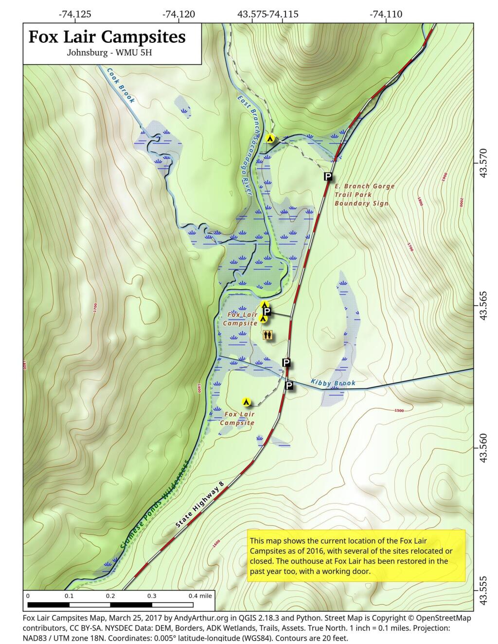
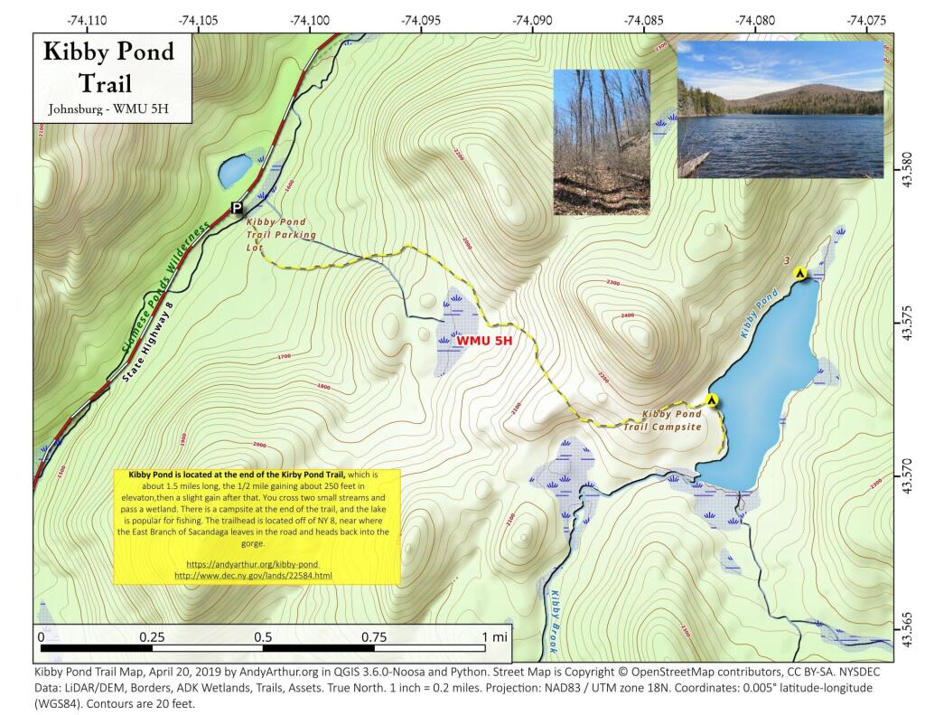
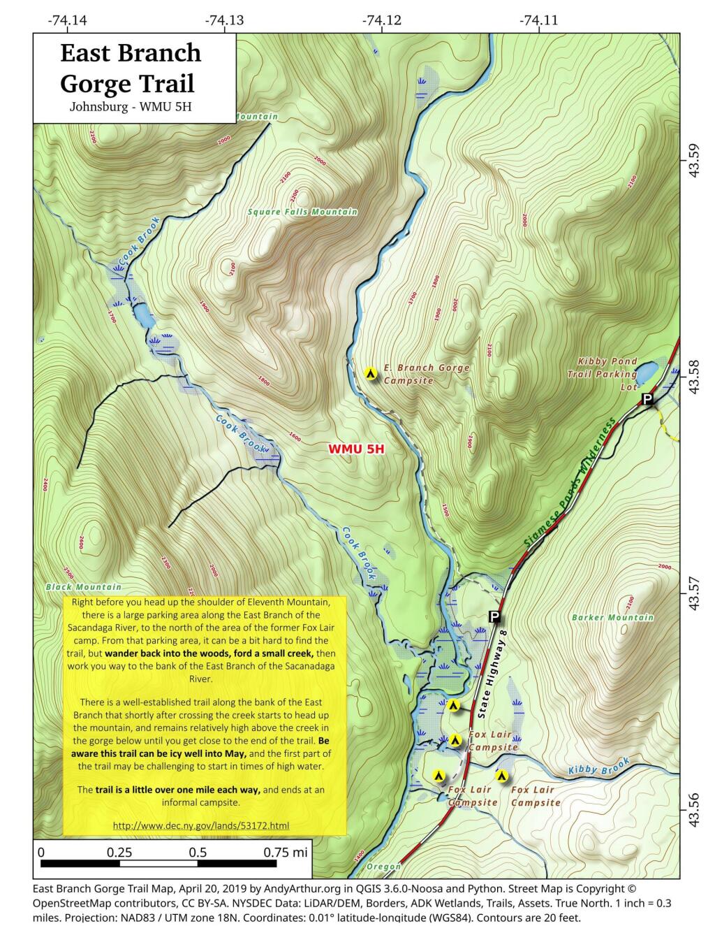
Here is a list of campsites, trailheads and other destinations along NY 8 and East Branch Sacandaga River. You can also get this as a Google Sheets.
| Name | Details | Latitude | Longitude |
| 11th Mountain Parking Lot | Large > 20 Cars | 43.5903782 | -74.0900314 |
| 11th Mountain Trailhead Campsite | Near large parking area for 11th Mountain | 43.5901834 | -74.0910822 |
| Boulder Rock Campsite | Cave-Like Site Against Large Erratic | 43.5384607 | -74.1215703 |
| Cod Pond Parking Lot | Medium 5 – 20 Cars, across from campsite 7 and 8 | 43.5301580 | -74.1455890 |
| Cod Pond Trail Campsite | At end of Cod Pond trail on pond | 43.5176969 | -74.1437559 |
| County Line Brook Trail Campsite | Along County Line Trail | 43.5242772 | -74.1892664 |
| County Line Campsite | End of County Line Trail | 43.5022688 | -74.1828085 |
| E. Branch Gorge Campsite | End of East Branch George, near Waterfalls | 43.5803187 | -74.1209517 |
| E. Branch Gorge Trail Parking Area | Small < 5 Cars | 43.5690250 | -74.1132232 |
| Eagle Pond Campsite | Near Eagle Pond | 43.5401509 | -74.1167243 |
| East Sacandaga River Parking Picnic Area | DOT Maintained Roadside Parking And Picnic Area | 43.4783862 | -74.2010766 |
| Forks Mountain Trail – Bushwhack to Auger Falls | 43.4685687 | -74.2457562 | |
| Georgia Creek Parking Lot | Medium 5 – 20 Cars | 43.4915171 | -74.1892866 |
| Girrad Sugarbush Trailhead | 43.4764458 | -74.2043731 | |
| Griffin Connector Parking Lot At Route 8 | Medium 5 – 20 Cars | 43.4703209 | -74.2248680 |
| Kibby Pond Campsite #3 | Far End of Lake | 43.5766649 | -74.0781098 |
| Kibby Pond Trail #2 | End of Trail | 43.5725581 | -74.0821443 |
| Kibby Pond Trail Parking Lot | Small <5 Cars | 43.5789951 | -74.1033601 |
| Little Joe Pond Campsite | At Little Joe Pond | 43.5055662 | -74.1423052 |
| Little Joe Pond Picnic Site | 43.5039558 | -74.1422817 | |
| Mud Ponds Campsite | At Mud Point | 43.5650797 | -74.1739273 |
| NY 8 Campsite 1 | Old Routing of 8, Near Kibby Pond Area | 43.5771279 | -74.1054574 |
| NY 8 Campsite 2 | Overlooks Cliff | 43.5650960 | -74.1160232 |
| NY 8 Campsite 3 | Long dirt road to open area | 43.5616391 | -74.1169664 |
| NY 8 Campsite 4 | Dirt road to campsite above Kibby Brook | 43.5612062 | -74.1138524 |
| NY 8 Campsite 5 | Old home site, sits on ledge above NY 8 | 43.5542527 | -74.1234025 |
| NY 8 Campsite 7 | 1/4 mile north of Cod Pond Parking | 43.5328656 | -74.1440210 |
| NY 8 Campsite 8 | Near Cod Pond Parking | 43.5316564 | -74.1459341 |
| NY 8 Campsite 9 (Seasonal Use) | Route 8 Near Little Joe Trail Pulloff With Fire Ring (Campsite Removed During Winter) | 43.5149220 | -74.1583197 |
| NY 8 Campsite 10 | Gravel Pit 1/4 mile south of Girrad Sugarbush Trailhead | 43.4761691 | -74.2072253 |
| Oregon Trail Primitive Campsite | Beyond Stewart Creek Snomwobile Bridge | 43.5194607 | -74.1339532 |
| Parking Lot | Medium 5 – 20 Cars | 43.5355769 | -74.1414217 |
| Shanty Brook Trail Campsite | Along Shanty Brook Trail | 43.5460737 | -74.1459537 |
| Shanty Falls Parking Lot | Small <5 | 43.5376556 | -74.1409559 |
| Square Falls | 43.5814233 | -74.1218099 | |
| Stewart Creek Bridge | 43.5204188 | -74.1356239 | |
| Stewart Creek Flume | 43.5204188 | -74.1356239 | |
| Stewart Creek Lower Falls | 43.5225332 | -74.1365675 | |
| Teachout Road Bridge Over Griffin Falls | 43.4733545 | -74.2236654 | |
| Teachout Road Parking at Griffin Falls | 43.4737995 | -74.2238438 |