Search Results for: map rear portion 2

October 12, 2015 update

Monday, Columbus Day was my first full day in West Virginia. It was a beautiful day with deep blue skies throughout the day and pretty good colors, at least at the middle elevations. The valleys were still somewhat green and by the time I got up to Dolly Sods, it was well past peak – but still amazingly beautiful. Still no cellphone service, so all of the blog posts from my trip will be posted late. Made a good breakfast of scrambled eggs with Shantung (?) mushrooms that I bought on Saturday afternoon at the farm stand in Coudersport, PA. They were delicious. Sat back and enjoyed the beautiful morning up on the big open campsite at had on Forest Road 13.

I liked the campsite so much, I seriously thought about camping back up there again – although it was a bit far north from my tentatively planned route. I woke up early but didn’t really rush around. I probably should have stayed later in the bed, but I’ve gotten into the habit lately of getting up early. Which is not a good thing because at the same time I’ve been getting up early, I’ve been staying up late. So by evening I’ve been tired. But not having to travel a lot of miles today, I figured to take it easy.

West Virginia Roads are crazy. They are all so narrow, so steep, and so twisty. When people say roads in West Virginia wind and wind, it’s true. But it’s the with of the roads, the lack of guard rails, the speed of other local drivers, that make driving around here kind of hair raising. Most of the secondary roads are little more then a lane wide, and when two vehicles have to pass, they have to virtually come to a stop.

This one road I was on, Virginia Route 32/2 in Lanesville, was a crazy 13-15 feet wide road (about the size of a typical interstate lane), except with two lane traffic sharing that one lane. Virigina 32/4 road was so narrow – that while it had a guard rail – the guard rail was hanging off the edge of the cliff. Lot of traffic too. Both cars had to basically stop to pass each time. I don’t think I have ever driven so many miles with my truck locked into first gear, or smelled my brakes burning a couple of times. After getting down one mountain pass, I felt like a could cook a turkey by placing it next to my wheel well. I tried not to ride the brakes, but I had to control my speed on these steep, twisty, narrow decent. Roads labeled Main_Route/SubRoute are scariest to drive in West Virigina by far. If you want white knuckle driving in West Virginia look for a route labeled like West Virigina 32/4.

Driving up to Dolly Sods is another crazy climb. Again, your 15 feet wide typical West Virginia Road, with no guard rail and steep descent off the side. At least the Dolly Sods road is relatively straight, with some long mile long climbs, where you go up 1,000 feet every mile or so. Dolly Sods is about 3,000 or so feet above the valley, so three miles of craziness. Fortunately, not a lot of people coming in the opposite direction. Still, I was happy enough to drive off the mountain later in the afternoon, again in low gear, then eventually down-shifting into 4×4 low, because I didn’t want to overheat the brakes. Maybe my fear of destroying the brakes on these hills is not rational – the brakes just passed inspection and aren’t making any unusual noises or have any problems that I know of – but brakes are something that scare me a lot on cars.

Brakes are designed to turn forward motion into heat to slow the vehicle. They are designed to have a lot of stopping power in their lifetimes, and modern brakes don’t fade severely until they get very, very hot. I’ve had too many brake problems on old junky cars and trucks, so using the brakes extensively puts a lot of fear in me. And I’ve watched too many Wiley Coyote and Road-Runner shows as a kid, and movies where cars drive off the shoulder, and roll dozens of times, not to be found deep in the hollow for month later. Or as usually happens in movies in California, a big truck rear-ends you, pushing you off the side of the hill, leaving you for death. I think that happened in the movie the China syndrome. Fortunately, I did not any roadrunners along the way, nor any coyotes. I did have a deer run out in front of me on one of those insane decent, but I applied the brakes firmly and aimed the wheels away from the edge of the cliff of death. Plus crazy locals racing past in opposite directions, because the traveled lane in West Virigina primarily exists for one vehicle going in one direction, and the other vehicle takes half of the shoulder where it exists. Even in the valleys, on major arterials, most roads are like 10 feet wide with a gravel shoulder that often ends for narrow culverts or other inconveniences that the DOT couldn’t be bothered to re-engineer for safety. Probably the widest, most modern arterials I’ve been on West Virginia – like parts of US 219 and WV 32 have no more then two 11 feet lanes and a foot shoulder. Certainly not the modern NYSDOT standard of 13-14 foot lanes and 8 foot shoulder.

Freaking insane driving down here.

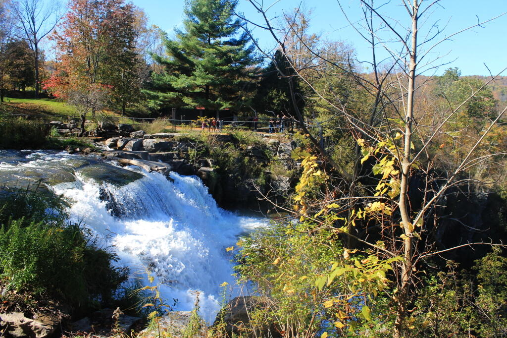
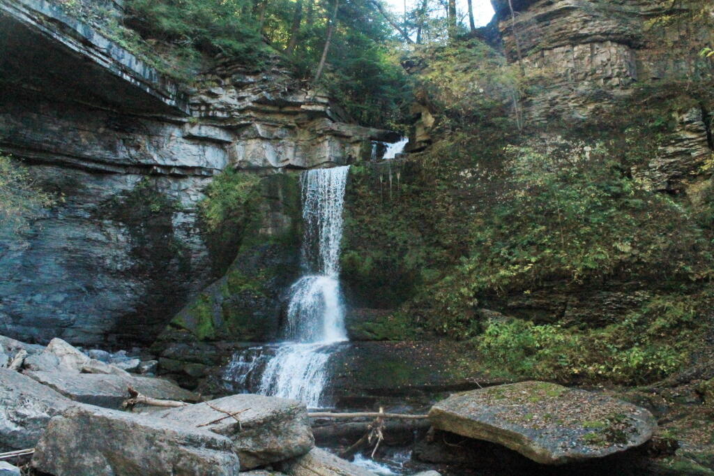
Despite the awful drive, Dolly Sods is stunningly beautiful. That’s the only way you can describe it. In the autumn the vast, lush fields of blueberries mixed with occasional deciduous trees and surrounding mountains is nothing short of stunning. I hope the pictures I took today came out, because it was a stunning place, from the narrow dirt road to the beauty in all directions.

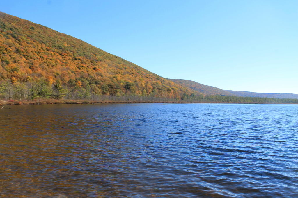
Looking down off Dolly Sands, you could see the various Blue Ridges, with some color still on them. Their is a campground on top of Dolly Sands and some roadside campsites about a 1 mile below Dolly Sods, but I didn’t want to spend the night up there, with potentially bad weather coming with a front coming through. Those roads are insane enough without them being muddy. Ankle hurt a little bit after stepping funny up there. I have my ankle brace I may put on tomorrow before hiking.

After I made it down from Dolly Sods, the drive on WV 55/4 wasn’t that bad. It was blacktop and had two lanes of at least 10 feet wide. Some crazy curbs and decents, and no place to pull off, but at least I wasn’t sharing a lane. WV 55/4 even had guard rails when it climbed down a mountain. And WV 55 running through the valley actually had nice big lanes and you could go in the straightaways 55 miles per hour. Of course, there was heavy truck traffic on it, and people weren’t happy that I was going cautiously around the curbs and only speeding up to 55 on the straightaways.

Eventually I found a place I could pull off and let traffic go by. Drove down to Seneca Rocks Visitor Center, hoping to find a payphone to call my folks to let them I doing okay, despite the white knuckle driving and no cell service up here, anywheres that I’ve been in West Virigina or Western Maryland. The Seneca Rocks Visitor Center is only open Wednesday through Saturday after September, so it was all closed up. Seneca Rocks was stunning. No payphone to be found here, but then I found a payphone at a general store that looked like a store out of Deliverance or maybe the Easy Rider.

I should have gone in and bought some milk that couldn’t have been that old but I was cheesed off about a call being $1, so I decided to hold off on calling my parents. I would have been fascinated to hear the accents – would they be strong, would they be Mid-western or Southern Applachian sounding? They’ll be startled enough to get a call from me, rather then just seeing a Facebook update. Seneca Rocks is a stunning view, especially right now with color peaking around it. I almost want to hike up Seneca Rocks and look down from it, but I don’t know if I will be back up that way or if my ankle will tolerate it.

I decided in the evening to head over to Gandy River dispersed campsites as shown on the map. I decided to take Forest Route 7 over from WV Route 55. Forest Route 7 was a nice drive, actually fairly wide, following an old creek, until the valley got narrower and the road got steeper and started to drop down to 15 feet or less, with a steep embankment. But I made it up there.

Then to get to Gandy, I had to take WV 33/2,
which much like it’s name suggested it was about 13-15 foot wide for both directions with a steep drop off and no guard rail. I think it only dropped 1,500 feet in a mile or so heading into Gandy. I didn’t realize I was in Gandy or the road to the campsites and ended up going north for 5 miles until I found a place to safely pull off of WV 33 and study the map.

When I realized from the map that the road to campsites was relatively flat, I figured I would turn around and drive 5 miles back south and eventually to the campsites. I don’t mind driving in the valleys – the roads tend to be somewhat wider and less scary there, even if they still have crazy curves that you have to watch out. The campsite I got on Gandy River looked pretty nice but once I started to set up the trees didn’t really work for a tarp, so I decided against setting up a tarp.

Rain is expected later tonight, but not until late, so I don’t really need the tarp. I’ll just make sure anything that could be damaged by getting wet is put away. And make sure to retire to bed before it the rain comes. Right now, it’s just starry out so the front must be a ways away. It’s supposed to be a quick clipper with a burst of rain over night with clearing out by afternoon.

Tomorrow morning ain’t supposed to be nice,
but a good chance to catch up on sleep. The campsite is not totally out of ear shot of another campsite a ¼ mile down the road, so I’ve had to keep the music down. I like West Virginia just not the driving. The scenery is outstanding. But I’ve had an enough with the white knuckle driving. I need supplies and food, so I need to get to a city with a grocery store, if at all possible.

I’m seriously thinking of heading east tomorrow and if it’s decent getting out on the Blue Ridge Parkway.
The Blue Ridge Parkway is no expressway but it’s at least two lanes wide and probably not nearly as steep or narrow as so many of the roads in West Virginia. The state of Virigina is much wealthier then West Virginia, so I suspect their roads are much wider and less scary to drive, even if some of them climb right up mountains. I was planning on spending one more day in West Virigina, but if the weather is decent, I could really get into checking out the Parkway – possibly heading farther south then expected.

Thursday and Friday, heading north to Shenandoah National Park to do Skyline Drive. That said, I’m still kind of disappointed that West Virginia isn’t as wild or backwards as I expected. Honestly, at least the part of West Virginia I’ve been in is no different then most of rural Upstate NY. If anything, the houses are somewhat nicer down here. Probably money goes farther down here, and people can afford nicer cars and yards.

There are some shacks, but nothing like what you see in Western NY and other chronically depressed parts of New York. Maybe I’m just not in the right part of West Virginia, despite this portion of the state not having much in the way of gas stations, stores, or businesses. I think a lot of the houses in this part of West Virginia are second homes, and it’s more tourists from Virginia then real Appalachia.

Maybe I need to go farther south in the National Forest to see real Appalachia. I think I’ve seen far more rural poverty in parts of Pennsylvania then down here.

Columbus Day 2015 morning

Good Morning! As I now have cellphone service, here is a brief update from Sunday. More updates latef.

As soon as I got into Maryland then West Virgina I lost cellphone service. I am surprised, as except for the Adirondacks and a few valleys in Western NY or the Catskills, I usually have good cell service. The same thing is true with the Northern Tier of Pennsylvania, and heck I had good service most of the way down through Pennsylvania on US 219 until I entered Maryland. Then there was no service in Maryland and West Virgina, anywhere I went along US 219 and down through WV Route 32. This is why I haven’t posted a update since yesterday morning.

Saturday night was a pleasant night up on Loleta Grade Road at the Allegheny National Forest. I had previously camped on Loleta Grade Road, but never took the part of Loleta Grade beyond where it leaves the East Branch of the Millstone Creek. Loleta Grade Road (FR 133) gets a lot narrower and somewhat narrower past the Millstone Creek and passes several marshlands and has a handful of campsites on it. It turns out the portion of Loleta Grade Road by East Millstone Creek is closed for reconstruction. They have a done such a nice job at building and improving roadside campsites throughout the Allegheny National Forest, while adding earthen barriers or rock barriers to protect forest resources from people driving past the campsites. Each campsite has a natural stone fire ring and many of them hardened with gravel. Loleta Grade was pretty with the fall colors. I took several pictures and will be uploading them as Internet or cellphone data service becomes available. The sun didn’t rise above the horizon of the forest until well after 8 AM this morning, although first light came a little before 7 AM. The campsite I was at was Forest Road 777, which I knew was a sign of good luck for the day.

Drove Along PA 3002 along the Clarion River to Ridgeway. That’s another part of the Allegheny National Forest I had never explored before. The Clarion River was pretty with the leaves turning, and looks like a lot of fun to paddle at least downstream. It has a good current but is deep and flat enough that it’s not white water by any means. I stopped along one of the State Game Lands where a creek – which I don’t know the name of – cross through a hollow in peak colors. It was beautiful. Eventually I made it to Ridgeway, and much like you would expect from that town, the approach into the city was a steep drive down. Ridgeway stunk of the hydrogen sulfide from paper manufacturing.

Then it was down US 219 all the way down to West Virigina. It’s a beautiful drive, but oh my gosh, does US 219 wind and have some steep descents and climbs. It also hits a lot of hick towns – some quite pretty and others dying coal mining towns – that are mostly sustained these days by government services and healthcare. Some nice farm lands and great sweeping vistas along the way, but not a lot of places to pull over and take pictures. To make matters worst I drank a lot of coffee this morning, and after a piss break at McDonalds bought more coffee and spent have the afternoon looking for places to take piss breaks. US 219 certainly winds a lot. The locals were blowing past me whenever they could pass me or whenever I would pull over. I don’t consider myself to be a slow driver, but with those narrow lanes and windy roads, I certainly had to hold back my speed a bit especially with my big lifted truck.

US 219 becomes an expressway after Clariton and the first ten miles of it is spectacularly beautiful. It reminds me a lot of the Taconic Parkway, only more modern and wider but with many of the same sweeping views of farm country and color packed hills. Some of the steepest hills I’ve ever driven on an expressway. Eventually the terrain becomes more rolling, with some larger farms. I ended up getting off a few different exits looking for a place to piss, and then got back on not finding one. I didn’t stop for a badly needed piss break until I reached a fast-food place just over the line in Maryland, where US 219 joins I-69 for a brief concurrency. The clerk at Burger King in Maryland there had a strong Southern Accent, but strangely enough when I got into West Virgina, the clerk at the gas station sounded modestly Appalachian but without much of a noticeable accent – even less then the Midwestern/Appalachian accent what I heard in Northern Pennsylvania. Being that I was in a hurry to get to West Virgina to figure out where I would camp and realizing that the Flight 92 memorial was 9 miles from US 219, I decided against visiting the memorial. It’s possible it was closed on Sunday. I got off US 219 at this one exit and drove through this large, old coal mining town with narrow roads and houses on the edge of a cliff, facing a mountain whose top had been blown off years ago to produce bituminous coal. At the bottom of the mountain was a vast tank that was being used to collect and treat acid mining discharge. Kind of sad to be driving past a place that time in many ways had left behind with nothing but a toxic legacy. Pennsylvania has a lot of old, small towns that were heavily built up during the industrializing era of America but seem to have little purpose today besides cheap housing and traditional communities.

South of the Pennsylvania Turnpike US 219 suddenly becomes a two lane road. You have to exit the expressway and then drive on another pokey local part of US 219 then you get diverted on a completed section of US 219. It’s obvious from the construction that Pennsylvania plans to continue the US 219 expressway all the way to Maryland border – a project that is requiring the blasting away of whole mountains and building massive bridges through the steep terrain of the Laurel Highlands. After driving a few miles on the congested highway, you get back on the expressway for a few miles before it drops back down two lanes, and your in Maryland.

It’s pretty wild driving I-69 in Maryland with it’s steep hills and the 70 MPH speed limit. At times I was pushing Big Red almost to the floor climbing over the mountains at the speed. I-69 is very twisty and steep. By interstate standards it seems to be sub-prime in design, but that may have to do more with the steep Appalachian terrain then the engineering that had to blast a 70 MPH expressway through. Heading west on I-69 traffic was fairly light. Stopped at a nice overlook on US 219 just after getting off of I-69.

I don’t have much good to say about Garnet County, Maryland or the state of Maryland more generally. US 219 crosses more of Western Maryland then most other roads, cutting through the widest portion of Maryland between Pennsylvania and West Virgina. A lot of farms in this part of the state, perched up on hills. Evidence of coal mining was all over, and honestly the terrain didn’t differ that much from the Laurel Highlands of Pennsylvania. Farther south of I-69, past a town named Accident, the terrain became more rolling and you could see to the east the Blue Ridge Mountains. A lot of wind turbines on the mountains. Unlike Pennsylvania, no burn barrels in Maryland. Apparently they don’t like the smell of burnt plastic as much as Pennsyltuckians. A lot of traffic on US 219 near Silver Lake in Maryland and the city of Oakland was pokey. People must come from Baltimore to vacation in Western Marlyand. But then it opened up to farm country, and I was in West Virgina without warning except for a brief county sign and a very stern sounding sign warning against littering – a $25,000 fine, lost of license, and jail for littering. Didn’t stop people from leaving litter on the road though as seen driving down US 219.

Maryland is probably a state best known for Spiro Agnew, our country’s only Grecian Vice President. Too bad he had to resign as Nixon’s Vice President for graft as Governor of Maryland and failing to pay on taxes on that graft. Also Martin O’Mallary, the former Democratic Governor best known for his unpopular gun control laws. Of course the whole time driving through the commonwealth, I drove carefully with an eye for cops, because I vaguely remember that Maryland is a state where they are really strict about their fender law, and are known to ticket people driving jacked up pickup trucks with tires sticking out past the fenders, as is the case with my truck. Lot of people have lifted trucks in Western Maryland, but that may be a southern thing too. People in Western Maryland may be relatively wealthy, with money from Baltimore and Washington suburbs to pay for their jacked up truck addiction.  Most had fenders but not all did. I am also not an expert on Maryland gun laws, but I figured I was probably okay just driving through the state with a cased, locked, and unloaded shotgun and 22 in back of my truck. I made it through the state, and took a deep breath once I realized I was in West Virigina. I have nothing good to say about Maryland, the state that is dominated by shitty Baltimore and Washington suburbs, with a neck following the Potomac River quite a ways out west. On the way back I will probably take US 220 through Maryland, which cuts through a lot narrower section of Western Maryland just to cover my fears of that god awful state that sticks between a lot of Pennsylvania and Virgina and West Virgina.

US 219 returns to being steep, windy, and narrow as you head into West Virigina and start climbing through the Blue Ridge Mountains. Actually, it gets narrow with sharp turns in Maryland  before you quietly cross – almost unannounced in West Virgina. The road is incredibly narrow, curvey, and steep climbing through the mountains. You think you’d never make it there, and eventually your in Thomas, WV. It seems like Thomas was a really hoping touristy place this Columbus Day Weekend, but as far as I could tell it lacked most of the chain stores. They probably are in a more populated place. Just down the road is Davis, WV. Davis has a bit more of a main street, it reminds me a lot of Lake Placid minus of course the Olympic tracks. Bought gas in Davis, one of those stations you have to go inside. I was hoping to hear the clerk’s strong West Virgina accent, but she didn’t have much of one. One of the older people in the store certainly had a classic West Virgina/Southern accent though. From there I took West Virgina 32 to the first major forest road I saw on map – FR 13 which runs along the top of Canaan Mountain. It was farthest north forest road of significance along the way, so I figured it was worth a try.

Forest Road 13, besides the unlucky number is astoundingly beautiful with marshlands and the kind of marshy forest you would associate with Dolly Sods Wilderness to the east of this area. Not a lot of maples of deciduous trees up on the top of the Canaan Mountain, but as you head down Forest Road 13, it descends into a deep hollow, following along a creek. Lots of colors from the hardwoods in this valley. This portion of Forest Road 13 is a bit scary to drive, because it’s only one lane wide, and difficult if not impossible in many portion for two cars to pass. Get too far off the road, and you could roll your truck, and assuming you don’t hit a tree, fall 100 feet or more into the hollow. A good gravel road, but so narrow once you down by the stream.

Put the truck in 4×4 low on the way back up the hill in case I had to crawl past a car on the way back up. Fortunately, I did not. Of course, when I got to camp I wanted to take the truck out of 4×4 low. Almost had a heart attack when I couldn’t get the transfer case to switch back to high. I forgot to go from 4×4 low to 4×4 high (and two-wheel drive), you have to have the truck in neutral when you hit the lever, otherwise nothing happens. I thought I was going to get stuck only being able to crawl somewheres, and have to find out what kind of services I could get by flagging down some random person. Literally had to get out the manual to find the answer – I knew there was a procedure, and they recommended you have the truck rolling when you switched – but forgot you had to be in neutral before shifting the case.

A few miles up Forest Road 13 from where I was camping was a big military encampment – there are like 50 brown Silverado pickups with brushguards parked up there. I thought it was Forest Service personal trucks – a big group for sure – but the rear plates said US Army. The guys I saw appeared to be military too. I don’t know if it’s military training or maybe it’s one of the groups that comes up here searching for old unexploded bombs that are occassionally found in the forest (the US Army used this area for war games and testing bombs during World War II). They are tent camping. I guess this must be part of wilderness training of some sort. Not something you would think you would find in the forest for sure.

On the way down into the valley, I spotted two campsites that were definite possibility for camping. I ended up camping for the night at one of the campsites, under starry skies. I don’t think the stars are quite as good here as the southern Allegheny National Forest, because we get some light pollution from the Washington DC metro area out here, but still much better then most of Upstate NY. A fairly big open campsite, but that was fine as I had extension cords to reach the lights where they needed to be on the trees. Reheated pork roast from a previous trip on the grill then started a fire. It was delicous and a nice evening. The sunset here is similar to that of the Allegheny National Forest – while I am 250 miles farther south, on the whole I’m jut as far west. Before dusk, somebody from Virgina stopped by to ask for directions to an overlook. I was shocked somebody would ask me, a New Yorker for directions. I guess like I must look like I’m from West Virgina with my big jacked up truck.

Sorry this is a long post, but it was a long day with a lot of adventures and stories to tell. I’m sure I will have more for tomorrow. At least I don’t have to drive any long distances tomorrow, as that US 219 got tiring with all the winding narrow road. I won’t be taking US 219 back north to Pennsylvania. It’s one of these roads you want to take once to see what the countryside is like, then avoid it because it’s so pokey, narrow, twisty, and steep. I probably will take US 220 up to I-99 and then overnight next Saturday night in Wellsboro in Grand Canyon Country, assuming the weather is good. I guess I could drive all the way back in Albany via I-81 / I-88 but that’s a hell of a trip in one day. I want to stay over somewheres in Pennsylvania on the way back, and I’d prefer to avoid the cities that I-81 runs through (Harrisburg, Scranton, among others).

September 2, 2015 morning

Good morning! Happy Wednesday. As they say, it’s Hump Day. Going to be a remarkably hot Hump Day for September, although temperatures in the low 90s are not unheard of this time of year. Most of the summer was fairly cool, so I guess now we have to make up for it. We are now at 66 degrees in thick humidity, with the fog starting to burn-off. The dewpoint is in the range of 64-65, which is why we are in a cloud of fog and swamp air. In the city, the folk appears to be burning off, and should be mostly gone by the ten o’clock hour. Hot and humid weather continues for the foreseeable future, until it breaks and the weather struggles to reach 50 degrees every day. It will happen that way for sure. But in the meantime, we are still looking at a very pleasant Labor Day Weekend.

Today’s post is kind of long, because my phone is broken, so I wrote a portion of it sitting out back last night, listening to the crickets in the muggy, 80 degrees evening air that smelled a little like corn silage they are harvesting the down the road. Cold beer and peanuts … I have a lot to get off my chest without even getting into the nasty politics of the day.

Wonderful morning, catching a circa-2000 year NOVA bus with a broken kneeler and no air conditioning. Because on these sticky morning, nobody wants to have air conditioning on the bus going to work. And people with disabilities or a sprained ankle, really want to climb two and a half feet to get up on a bus that can’t kneel due to a stuck air bag suspension. It’s lower then my truck, but with my truck I can use the steering wheel to pull me up, and the seat is closer. I guess it’s September, so air conditioning is optional for professionals heading downtown in a suit. It’s NOVA bus 3024, running the Route 18. I will file a complaint with CDTA, so it gets marks down in their statistics.

Did you see that article about unlocked cars being broke into in Rotterdam? This time I made sure to lock my truck because I really didn’t want to have the three-quarters empty RemOil can stolen, among other things that are slightly more valuable like the radio. That said, I think my driveway is far enough back and the neighbors nosy enough that they would see a theft. Plus, I think Rotterdam is a little more rough around the edges compared to Delmar, but who knows, especially now that kids are back in school, and suburban kids looking for money to score some pot have access to Ebay at home..

Went down fishing at the Hudson River. Didn’t catch anything, but I don’t care. It was mostly to kill time, and sit down by the river and enjoy the evening. Saw a big oil barge pass by and some kayakers. The waterlevels on the river was quite high, probably caused by the near full moon causing unusually high tides. The water was only 1-2 feet below slopping over into Henry Hudson Town Park. It was a lot cooler down by the river then certainly in my un-air conditioned apartment. It was pretty dark by 8 PM and while I could have spent all night down fishing there, with my broken cellphone, I had nothing to play with, so I packed up and headed over to Walmart to pick up a few supplies.

The primary reason I went to Walmart was to get some high-ankle hiking boots to wear as I start getting out and walking again. I could have gone more high-end and gotten some Timberland Boots or something similar, but with all my walking, I tend to wear them all out at about the same speed. The low-cut work boots I’ve worn all summer have been fine and comfortable until I sprained my ankle. Now they don’t offer much support for my foot. I will save the low-cut boots for next summer, and hopefully each day I will be able to walk a little farther. The new boots definitely need to be broken in, but the best way to do that is wear them and walk around. Tomorrow, I plan to do a little more walking, but nowheres I can’t catch a bus as necessary.

My replacement cellphone has arrived but I have to go to up to Colonie to sign for it. Hopefully I can get both the gun I’m still waiting for clearance on and the phone at the same time. If for some reason I can’t pick up the gun today, I still will drive up to the store to get the phone. I want to get it on the WiFi either at the library or work on Thursday, so I can get my programs and podcasts on the phone before I head up to the Adirondacks for the long weekend for camping. I’m not sure if this phone has many features as my old one, but one thing I like about it is the built in FM radio. That will come in handy for listening to NPR news on the way home from work. I think it will also run the GPS app I use, WordPress, Twitter, Facebook, Instagram, Foursquare, Waze and Moovit just fine. It will play my music. Not sure if it has less internal memory, and the camera is somewhat crappy with a fixed lens. Maybe I got to start shooting with Digital SLR camera once again. I really don’t need much beyond that. It was only $43 refurbished. Hopefully it will hold up better then the stupid Samsung Galaxy Ace Style that both the original and replacement broke. The one that isn’t working at all, may be hit with several rounds of .22 fire this weekend if all goes well. Once I burn the plastic off, I can recycle the remaining scrap metal.

Still haven’t heard from the gun shop about the delayed NICS check. This afternoon I will call the shop. It’s possible I just didn’t get their call back when the phone wasn’t working right, but I would have thought I would have gotten a voicemail. I haven’t followed up, because I’ve been busy, and honestly, I wanted to combine the trip for picking up my replacement cellphone with picking up the gun. Tomorrow, they can legally complete the sale, even if a final check doesn’t come back. Most places will complete the sale without a final NICS result, so I am fairly sure I’ll have the gun by the Thursday (and therefore the holiday weekend). If they refuse to sell without a final disposition, I will go to another gun store on Friday. Watch as NICS clears instantly at a second gun shop (rolls eyes). There is no reason for it to come back denied, as I’ve never been convicted of a felony or subject to involuntary confinement for mental illness. I answered the questions truthfully, to the best of my knowledge. I mean doubt I would be convicted of a felony and not know about it. Usually they tell you about such things. Maybe I’m not perfect with youthful blemishes on my record, but no reason not to prohibit the sale to me.

The delays make me wonder if I did something wrong, but NICS delays are not unheard of when somebody else has a similar name and need to confirm a record. My mom was skeptical when I told her. I’ve broken bones and cussed, but been convicted of no felonies. All the official documentation say that NICS delays aren’t a reflection on the character of the individual – the reason for delay of the approval or need for further investigation has nothing to do with the person getting the NICS clearance. Many times it’s just a similar name and a need to make a phone call to clear up confusion. Other times, a record needs to be pulled that requires a security clearance or other high-level approval. Most people say NICS delays are fairly random – I may buy my next 5 long guns, by walking in and walking out with the new gun – after an instant check. I’ve heard police officers and military sometimes get delayed with NICS.

When I become a resident of Pennsylvania, handguns will be purchasable with the ease of long guns in NY. That’s the norm in most states. The previous gun I bought last year, they spent 15 minutes on the NICS processing and 45 minutes trying to find the box the box the gun came in. They ended up selling the shotgun to me that I bought last year without the box or the manual. Which is fine, as I just printed up the manual myself. I don’t know at this point if I will bother getting finger printed and a NICS User PIN, but I know when I move to Pennsylvania, I will take the course to get my Concealed Carry License. The Pennsylvania CCL is a reasonable process, and while the state is not must issue, the state can only deny for cause. I’m not super into getting my CCL to carry in the city, as much for the convenience of buying future guns (no NICS required) and because it makes it legal to have a loaded handgun in your truck in most states that honor PA concealed carry licenses. In PA you can open-carry handguns when hunting/hiking (and in most public accommodations) without a permit, like most normal states (e.g. not New York).

Reading the recent article on Politico NY comparing the Southern Tier and Northern Tier of New York, I think most of the things they say are true. There are more jobs total in the Southern Tier of New York, as it’s more populated with Binghamton, but the economy is healthier with fracking. I never understood the ban on fracking. It seemed like the anti-frackers didn’t want any drilling activity in their neighborhood, no matter temporary in the inconvenience might be. Fracking boom is basically over in Penns. They believed what they wanted, and found ways to use fear, uncertainty, and doubt to get it banned. FUD-ers don’t believe in science, logics, or statistics, at least when it doesn’t agree with their political disposition.

But Pennsylvania not only has much better gun laws (even if they aren’t as good as many Southern and Western states), and they manage their state parks and lands much better. NY State Parks are often garbage dumps with decrepit facilities. There is very little pride in demoralized NY state parks workforce. Penns has publicly funded shooting ranges, and it’s rare to find litter on their state lands. Open burning and burn barrels are allowed on farms and rural houses, as are bonfires. I love fire, don’t tell me what I can’t burn on my own land, as long as I’m not annoying the neighbors too much. No emission inspections in Pennsylvania except for the most urbanized counties. Laws on pickup truck lift kits are reasonable. Lots of state lands offer ATV and snowmobile riding opportunities (although I’ve heard the NY State snowmobile trail system is better, there are virtually no-state funded ATV trails in NY). They don’t have animal rights extremists poking their noses around hard-working, marginal farms as too often is the case is New York. The Penns ban on Sunday hunting, and prohibition of hunting with semi-automatic firearms sucks, but I’m not sure if that applies to small game (22 ammo) or coyote hunting. Pennsylvania also has a lot of hunting pressure with over 1.5 million hunting licenses sold per year (versus 800k in NY State) — they filmed the movie The Deer Hunter there for a reason. I don’t know what the policy is in Pennsylvania about silencers, but most states are become more open to allowing them, due to growing public concern about hearing damage.

After I sprained my ankle I stopped looking at jobs and apartments in Pennsylvania. I was looking in the Scranton-area, as that’s the easiest for moving and day trips for interviews. I’d rather be farther west in the state for the Allegheny National Forest and some of the state forests, but Scranton is not that far away from the great public lands of the Northern Tier. The Catskills are also within a reasonable distance for recreation purposes. I would miss the Adirondacks, but if I could get established in Pennsylvania, I could eventually own my own land in the country, quite possibly off-grid, and it would be a lot like camping in the woods. I could always take a week off and go to Adirondacks from Penns, as long as I left any handguns I owned home. PA’s off-grid laws seem reasonable per that Off-Grid Fixed By Doc Youtube channel, but obviously there is more restrictions then out west, especially if your living in a building with a permanent foundation, and not just a so-called temporary cabin.

Those hills in the Scranton-area would be murder on the brakes for my jacked-up truck though, but I guess I could always just make sure to downshift earlier and think about investing in bigger binders to better handle the heat. I guess I will get back to looking, once my foot is better, but honestly, I expect to probably spend another year or two in New York before I take the plunge. Relocating is kind of challenging, when you don’t know an area except from what you’ve read on the Internet and seen on maps. My job pays well, and the health insurance has been good to me since I sprained my ankle. At times work in Albany is entertaining, if not downright funny in a sardonic kind of way.

Good morning! Happy October. 🎃

At this point, September is but a memory. A good one but much too short. October is here and will come and go in due time but I plan to maximize it. And November is fun with Thanksgiving and all of those holidays. The first full week of November both Tuesday and Friday is a holiday, which offers possibilities for another trip after my October vacation probably out to Madison County before rifle season, assuming it’s not to wet or snowy.

Mostly clear with some fog 🌫 and 54 degrees in Delmar, NY. 🌄 There is a north breeze at 5 mph. 🍃. The dew point is 53 degrees. I am not complaining, it’s October out there. Mornings could be a lot cooler and wetter, as we experienced yesterday. I couldn’t believe how long we got stuck in that rainy pattern yesterday. But it was good to stay home and indulge in too much 15 bean soup 🍲 and slightly stale whole-wheat homemade bread. 🍞 The rumblings of my stomach tell me that the bean soup and bread are done. 😋 But it was good. Apparently I don’t have enough gas currently, I am cooking up more red kidney beans up this morning. 🤯

That rain came and stuck around most of yesterday. 🌦 It finally cleared late, and I got down to the library and ended up returning home at 5 PM with a stack of nine books. Lots of good reading material. 📚 Of course, the book I had to open first was one about food and health and nutrition. I don’t know why I am so into cooking and eating healthy these day, but it’s just fascinating to learn new things. I like good fuel for my body as it keeps me going to when I go out for bike rides and hiking.

Yesterday I rode out to Voorheesville at 5 PM 🚴 and then around the neighborhood doing about 14 1/2 miles for the day, which wasn’t bad before it started to get dark out, when I sat out back and had some cottage cheese with mango, strawberries and pineapple and some ginger. 🥣 I really have been into ginger lately, I like the zing, and the fact that it makes you at less achy at least in one’s mind. Not sure if that’s completely scientific, but it’s way to give boring foods a lot more taste, like most spices, without adding a lot of sugar, salt or fat. Other then that, it was a pretty lazy day, eating way too much bean soup with a rumbling stomach from all those beans. But between the bean soup and eggs this morning 🍳 with some help from the food processor, I got rid of a lot of vegetables that would otherwise become compost. 🥕

The government shutdown is over, 🏛 which is good as opens up more vacation options, including heading down to Table Rock / Blackwater Falls area of West Virginia. 😀 Kind of a long trip though, and gas prices are going up through the roof once again ⛽ and I know it puts a lot of load on my old truck 🚚 but it might be a fun trip. I could still change my mind, I figure I will start out in Pennsylvania doing the rail trail, and if the weather or anything else changes my mind I can always go to the Allegheny National Forest or back north to New York State like the Southern Tier and the Finger Lakes. 🤷

All $2,300 has gone out the door on Friday, 💸 and I’m above the minimum balance, though I don’t get paid until a week from Tuesday, aka the day after Columbus Day, and soon after that my credit card bill is due. 💳 You know, rent, car insurance, retirement, and investing. I guess technically the last two things aren’t expenses, but they are money gone for now. I might have to dip into the rainy day fund, especially if I decide to retire some extra credit card debt early prior to vacation, especially as the web hosting bill goes out next Sunday. 💻 That said, it looks like I will be close to $16 for the first week of running ads, and it looks like there is ways I can further optimize the blog for additional revenue. It won’t make me rich 🏚 but it should cover the cost of blog hosting, allowing me to continue to tell my story and have fun posting maps and other useful information. 🗺

After the morning walk 🚶, I am going to get out the rattle can, newspaper, masking tape and put on another layer of paint over the rust spots on Big Red. 🛻 I’m sure the salt spreaders are on their way. I decided at this point to just use not quite so expensive body primer and duplicate match but instead just red rust proofer and I can sand down later and add duplicate color but I don’t care that much, my truck is 12 years old and in a year or two I’m going to have to throw away at any rate. I figure by the time I head out to the folks house for Sunday things should be dry enough.

Also going to run down to the store 🍏 on my bike 🚲 and get more apples, along with frozen fruit like broccoli 🥦 and peas in part to bring out for Sunday dinner as while I’m sure the lasagna will be good I’m sure they won’t have enough good healthy veggies to go with it. Mom says she’ll include a salad 🥗 and garlic bread but I feel like both are basically junk food – salad has some fiber but for the most part is really nutrient poor and mostly an excuse to load with fats like dressing. I’m going to bring a big container for left overs which I’ll freeze for future weeks in small portions with vegetables for complete meals like to take on vacation for quick dinners after a full day of riding. 🚲

Looks like it will be a great week for riding to work. 🚲 I might take off Wednesday to ride the Albany Electric Trail and explore the Martin Van Buren Historical Site and get more apples 🍏 at the Golden Harvest Farms in Kinderhook. And then I can pack for the weekend. Assuming they let us leave early come Friday for Columbus Day Weekend – I have to work Friday as the other director is off – I might head up north or out to Schoharie. I’m kind of thinking up north as it might be a great weekend at Piseco-Powley and I’m kind of I’m kind of interested in the Little Falls Cheese 🧀 Festival. Saturated fats are bad but so delicious 😋.

I need to look at getting another rear light for my bicycle. 🔦 I’ll have to look on Amazon and Ebay. I want to have good lights before going on vacation, as while I don’t plan to ride after dark, it gets dark so early this time of year, and it’s important for safety to be seen with dusk coming so early. Also need to top off the windshield washer fluid in my truck, and then I might go up to Wolf Hill to ride this afternoon on the bike trails up there. Hopefully not get my bike too muddy in the process, but worse comes to worse, I can watch it off.

Gorging on Gorges, An Adventure, Day 1

About a month ago, I took a trip I gave the name “Gorging on Gorges”. As the name would suggest, most of the trip involved visiting various gorges, taking photographs of them, and otherwise exploring them. About half of them I had previously been to, while the rest were new. I also visited several other state parks, state forests, and national forests – and did something I haven’t done in a long time – camped one night in a developed campground.

Towards the Park

I started out my trip from Albany, taking US Route 20 West from I-88. I really wanted to avoid expressways for the bulk of my trip, is my general view is that expressways are the best way to get across America without really seeing anything. It’s more then a philosophical argument for me – what’s the purpose of a vacation if your rushing from point “A” to point “B”.

The first part of the trip, I drove to Chittenango Falls State Park via Nelson and beautiful farm country so high above. I walked down into the gorge, and up and around the falls. The color was somewhat muted, but it still was quite pretty. Then I headed off, taking some side roads as recommended by my GPS’s most direct route, and ended up passing a few miles from Labrador Hollow and the beautiful Labrador Pond, and said, heck, I got to stop on by there.

I drove down to Labrador Pond parking area, and hiked down to the pond. The colors were still not fully-turned on Jones Hill, but on Labrador Mountain were well past peak. Despite the crowds of fall foliage peepers from Syracuse, crowding the area, there were adequate opportunities for solitude. I walked down to the lake, snapped a few photos, then hiked the nature trail/boardwalk. It was nice. It also was great to see the boardwalk being used by a disabled man – he could get out and enjoy nature, despite his difficulties he had walking. One of the large dairies in the area was spreading something on fields nearby, and it sure stunk – it seemed nastier then fermented grain, although that’s probably what it was. Didn’t stick around too long, as I had places to go.

Somewhat Faded Colors

Drove down through Prebles, another deep, rich agricultural valley, dotted by large dairies that take advantage of the area’s rich soils for producing many bushels of corn on each acre. Got held up for about 5 minutes during a paving job, where they had the road restricted to one lane, for what had to been a half mile or so. Noticed how most of remaining trash burning barrels had disappeared from the landscape, that might have only been there 3 or 4 years ago.

Then it was off to Homer, where I passed a moose, made out of welded scrap metal along the road. It was kind of a neat roadside attraction, and I really should have stopped and got a picture, but I had a tight schedule and was burning daylight. I would come to later regret not getting that picture, but heck, I figure I can probably find a picture of it on the Internet using Google Images or Flickr. If not, it will certainly be there, the next time I find myself going through this roadside wilderness.

Millard Fillmore Historic Marker

I got lost on my way to Moravia. Not really lost, because I was following the GPS, but because I had programmed the “most direct route” rather then “fastest route”, the GPS.decided to take me up a rough dirt road through Hewitt State Forest. I declined, and eventually the GPS found a new route, that happened to take me past Milton Fillmore’s birthplace. There is now a picnic pavilion and a some landscaping in that location. I turned around, snapped a few pictures, and explored it briefly. I wanted to a get a picture for dad for his historical markers collection.

Then it was off to Fillmore Glen. I was running a bit late at this point, but it’s a pleasant drive down to Filmore. The landscape is pretty rural until you drop, rather quickly into Moravia. Moravia is a pretty, small rural town; the glen is located at far southernly end of the town. There was a bridge being replaced in town, and you had to wait, for what seemed like an eternity for the light to green on the on-one lane bridge.

Finally, I got to the park entrance. The older guy there, grumbled when I said I had an Empire Pass. He was like “where is it – I can’t see it”. The rear window on my truck where the Empire Pass is tinted, but not that dark. I was slightly annoyed that the park entrance guy wasn’t friendly, and I forgot to ask for a map. I was kind of rushing. Got parked, and there was a big wedding going on, complete with horse drawn carriage. Crossed the “Dry Creek” and started up the trail, first to the Cow Shed falls, then decided to take the Northern Rim Trail. It wasn’t apparent at first that it was the rim trail, but I didn’t have a map. I actually printed up a map, and had it my truck, but I of course forgot it.

Small Waterfall in Gorge

The Northern Rim climbs a fair bit, then runs along the rim, with very limited and occasional views. It crosses a pretty little creek that tumbles down the gorge, and eventually leads to a path down to the gorge trail, three-quarters the way up the gorge. I decided to hike down to the gorge trail, and then head back down the gorge towards the parking area. I missed a bit of the gorge trail, and the overlook, but so be it, time was tight.

The Gorge trail was scenic, but certainly not the most scenic of gorges. There were several small waterfalls, and some stairs and bridges, although most of the trail was gravel along the edge. The “Dry Creek” had plenty of water, but in general, the gorges was smaller then other Finger Lake gorges. There were several glens of interest, but the most beautiful portion of the glen was the Cow Sheds in the button of the gorge. Cow Sheds falls, are the wider portion of the gorge, where at one time, historically, cows would gather for shelter in severe or cold weather.

Cow Sheds Falls

Snapped a few more pictures of Fillmore Glen, and it was off to Ithaca. I made pretty good time to Ithaca, although I admit I certainly wasn’t poking along. I really should have stopped more places, but I wanted to get to the Finger Lakes National Forest relatively early so I could set up camp and/or make alternative plans should my desired campsite on Chicken Coop Road be unavailable. Passed a giant bull statue on a farm, along NY 38, a few miles south of Moravia. I really should have stopped for a picture, but I was burning daylight, and the Finger Lakes National Forest, was over an hour away. I think this is the one, that the farmer paid like $10,000 to haul from an abandoned Steakhouse in Binghamton to the farm. I am sure the bull will be there for a long time – in case anybody forgot what is raised on farms.

Then it was down to Freeville.. The only thing real remarkable about that town, was the pine barrens and swamps, consisting of heading into it. When you think of the Finger Lakes, you tend to think open landscapes and farms, at least until you get mostly south of them of them, or in the highest points to the west. But not here. The Finger Lakes Trust owns some land, on the north side, where it the land is mostly the backwaters of the Oswaco Inlet.

Finally made it to Ithaca by 4:45 PM. I was lucky at this hour that traffic wasn’t too much of a slog by Ithaca standards, then I was off heading up Trumansberg Road. It seemed like an endless drive. Finally made it to Perry City, and then to the Finger Lakes National Forest. There was no sign of the government closure when I got there, but a bit disappointed, my favorite campsite on Chicken Coop Road was already taken. It was off to campsite on Potamac Road, just past the hunting camp.

I wasn’t thrilled by campsite, a big field campsite, but it had some trees along one edge for hanging the flag and lights. It was pretty good site for observing the stars, although there was a hunting camp down the road a little ways, so I had to keep the music down. I really don’t want to piss off the hunters. I gathered up some firewood from the woods, and got a fire started. The sun was fading fast, but so be it. I wired up my lights, some Christmas lights, and got the spot light on the flag.

It got dark, and I tuned into the Ithaca Progressive Radio Station, and gazed on the stars for a couple of hours. Nibbled on some snacks, cracked open a beer or two. Tossed some more wood on fire, and was happy to finally be on vacation.

It was a good first day… more adventures to come.