Map: Onteora Lake Trails
Download a High Resolution JPEG Image of the Onteora Lake Trails or an Adobe Acrobat Printable PDF of the Onteora Lake Trails.

Bookmark my free Interactive GPS Map for your phone:
https://andyarthur.org/ny
... shows your location as a blue dot in relationship to campsites, trails, state land. This online map requires cell service, won't work in remote country, so also bring a paper map.
Free Download of New & Historical USGS 1:24k Topograpic Maps
Interactive maps with backcountry and roadside camping: New York, Pennsylvania, West Virginia & Vermont. List of NYS DEC Lean-Tos and Firetowers.
Google Spreadsheet with Roadside, Primitive and Pay Campsites
More about Bluestone Wild Forest...
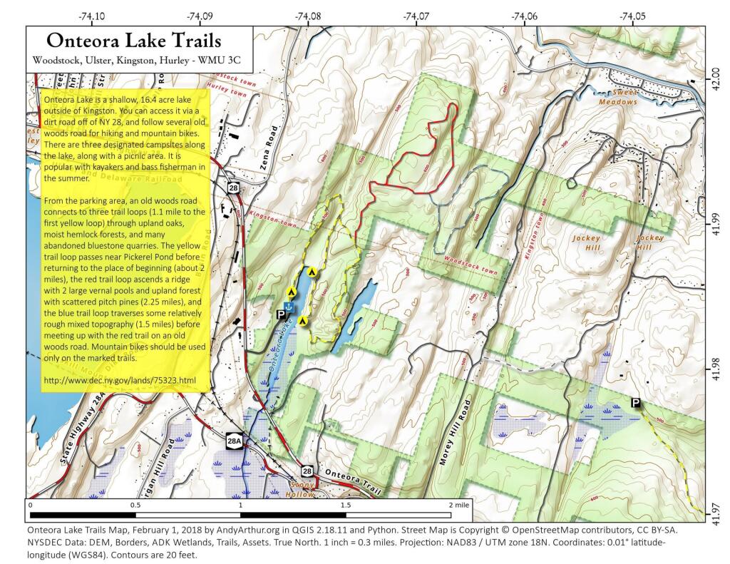
Located at one of the most popular gateways to the Catskill Park, the 3,000-acre Bluestone Wild Forest, just 3 miles west of historic Kingston in Ulster County has something for everyone. Developed access is provided to Onteora Lake off State Route 28, one of the few publicly accessible lakes in the Catskills. Its lake, ponds, trails, old quarries, hemlock and oak forests on gently rolling hills - and an occasional cliff- are ideal for hiking, mountain biking, fishing, hunting and cross-country skiing. Bluestone WF is in the Towns of Hurley, Woodstock, Ulster and Kingston. This wild forest consists of numerous smaller parcels scattered throughout the region and a loosely connected mosaic of parcels making up the largest piece between Zena Road (Route 39) and Route 209, which is described below.
More about this state forest: http://www.dec.ny.gov/lands/75323.html
Maps and Interactives
Onteora Lake
Onteora Lake Trails
Jockey Hill Trails
... photos, maps and other content from from Bluestone Wild Forest.