Search Results for: map old route 8 campsites

Old Route 8B

Old Route 8B is a 1915-era routing of NY 8 and 30 between Wells and Speculator that is now a dead-end after the lower bridge was closed some time ago. It runs between Auger Falls and Speculator, passing closely by Austin Falls. Old Route 8B is most famous for Robert Garrow killing a camper at the Robb Creek Mill and then fleeing up Fly Creek Road. There are several campsites along the road, and Austin Falls is a scenic location where the Sacandaga River runs through a narrow floom. The road, while paved with concrete and letter covered with two layers of asphalt only receives the most minimum of maintenance, and is quite rough and disjointed in locations. Old Route 8A refers to the 1915 routing of NY 8 and 30, which at one time ran closer to Auger Falls and wound into the valley, taking a closer path to the Sacanadaga River.

Below is a list of lean-tos, campsites, parking areas, and other assets along the Northville – Placid Trail πŸ•οΈ

Link to anΒ  Interactive Map of the Northville Placid Trail.

Type Name Description Coordinates
Hand Launch Ceder River Flow Boat Ramp Hand Carry Launch, Ramp 43.725826369700904, -74.47289916126694
Lean-To Beaver Pond (Aka Cedar Lakes Lean-To #2) Β  43.625969396804386, -74.54927150370021
Lean-To Carry Lean-To Β  43.67874488347091, -74.49549821879448
Lean-To Catlin Bay #1 Lean-To Β  43.99801269269887, -74.39278456108421
Lean-To Cedar Lakes #1 Lean-To Β  43.628125665037935, -74.54047323992656
Lean-To Cold River #2 Lean-To Β  44.14251664317184, -74.13035824291548
Lean-To Cold River #3 Lean-To Β  44.091459278051204, -74.25764175084498
Lean-To Cold River #4 Lean-To Β  44.09139025333258, -74.25573480252505
Lean-To Cold River Lean-To #1 Lean-To Β  44.14272737628489, -74.12984021065587
Lean-To Duck Hole #1 Lean-To Β  44.14162687400988, -74.10693734676616
Lean-To Duck Hole #2 Lean-To Β  44.14167686466829, -74.10654354672256
Lean-To Hamilton Lake Stream #1 Lean-To Β  43.39741359517532, -74.45529759002217
Lean-To Hidden Cove Lean-To Β  44.00265528819394, -74.38648026325164
Lean-To Kelly Point #1 Lean-To Β  44.02880023617087, -74.36730798599064
Lean-To Kelly Point #2 Lean-To Β  44.02870256717196, -74.36713034867948
Lean-To Moose Pond Lean-To Β  44.182843382402666, -74.07364102375995
Lean-To Mud Lake Lean-To Β  43.342671073157994, -74.45629078563864
Lean-To O’neill Flow Lean-To Β  43.875596840936154, -74.36642623697053
Lean-To Ouluska Pass Brook Lean-To Β  44.120221281603584, -74.18744717390932
Lean-To Plumley Point #2 Lean-To Β  44.06559891610762, -74.32761224546002
Lean-To Rodney Point #1 Lean-To Β  44.04140938489936, -74.35014909639557
Lean-To Rodney Point #2 Lean-To Β  44.042976745412616, -74.34933464753136
Lean-To Seward Lean-To Β  44.106244137686204, -74.2091536427719
Lean-To Silver Lake Lean-To Β  43.29193545679836, -74.4237351676776
Lean-To South Lake Lean-To Β  43.58724480971, -74.62157883837274
Lean-To Spruce Lake #1 Lean-To Β  43.52728411257782, -74.6099246975027
Lean-To Spruce Lake #2 Lean-To Β  43.53463062983387, -74.60808580306896
Lean-To Spruce Lake #3 Lean-To Β  43.53712972792447, -74.60820962802477
Lean-To Stephens Pond Lean-To Β  43.818673668554965, -74.42052487172707
Lean-To Tirrel Pond North Lean-To Β  43.887344477557306, -74.37880062606054
Lean-To West Canada Creek Lean-To Β  43.58698761405157, -74.61399797100106
Lean-To West Lake #1 Lean-To Β  43.59316222884976, -74.62688668431306
Lean-To West Stony Creek Lean-To Β  43.22474428954461, -74.26933345717664
Paved Parking Lot Lake Durant Northville Placid Trail Parking Lot Paved, 12 Vehicle Capacity 43.84219550506574, -74.3862742856788
Paved Parking Lot Northville Lake Placid Trail Parking Lot Paved, Good Condition 43.84213270187873, -74.38656792328511
Primitive Tent Site Canary Pond Campsite Β  43.30513256312245, -74.4472062440692
Primitive Tent Site Cedar Lake Dam 1 Β  43.62894580965635, -74.53639939387939
Primitive Tent Site Cedar Lake Dam Tentsite Β  43.62937624507422, -74.53679785644344
Primitive Tent Site Cedar River Flow Tentsite Β  43.70292480315104, -74.48713041165333
Primitive Tent Site Fall Stream Tentsites Β  43.49661052800474, -74.53713112743992
Primitive Tent Site Jessup River Tentsites Β  43.51246207852797, -74.57229710138834
Primitive Tent Site Kelly Point Tentsites Β  44.02910364406153, -74.36670207204214
Primitive Tent Site Moose Pond Tentsites Β  44.18274441156179, -74.07408240028583
Primitive Tent Site Moose River Plains Campsite 01 Live 43.72667672123972, -74.47410026642402
Primitive Tent Site Moose River Plains Campsite 02 Live 43.72665150100841, -74.47331107300782
Primitive Tent Site Moose River Plains Campsite 03 Live 43.725959512295866, -74.47389996564202
Primitive Tent Site Moose River Plains Campsite 04 Live 43.726067692208126, -74.47423264719026
Primitive Tent Site Moose River Plains Campsite 05 Live 43.725563790898704, -74.47417512282912
Primitive Tent Site Moose River Plains Campsite 06 Live 43.72522313374867, -74.47458303719159
Primitive Tent Site Mud Lake Tentsites Β  43.59647433847274, -74.61354076182431
Primitive Tent Site O’neill Flow Tentsite Β  43.87567135918534, -74.3666467203306
Primitive Tent Site Rock Lake Campsite Β  43.265591839994535, -74.41543516012669
Primitive Tent Site Salmon River Tentsites Β  43.907925071619914, -74.38530801916977
Primitive Tent Site Shattuck Clearing Tentsites Β  44.08679657756681, -74.26368397541134
Primitive Tent Site Silver Lake Tent Site Β  43.29112770008321, -74.4240469986026
Primitive Tent Site Spruce Lake Tentsite Β  43.53695545329776, -74.60818912022354
Primitive Tent Site Tirrell Pond North Tentsites Β  43.88594343639596, -74.37834897628142
Primitive Tent Site Trailside Campsite Β  43.2716741112023, -74.43107546264162
Primitive Tent Site Wanika Falls Tentsites Β  44.19944690357389, -74.05663862305364
Primitive Tent Site West Lake Former Caretaker Clearing Tentsites Β  43.59389874347195, -74.62560220247346
Primitive Tent Site Whitehouse Campsite Β  43.373430193527696, -74.43578942968477
Primitive Tent Site Whitehouse Campsite Β  43.37406302094423, -74.43516794694158
Primitive Tent Site Woods Lake Campsite #2 Fire Pit, Water Front Campsite 43.25071034607129, -74.31177480398298
Primitive Tent Site Woods Lake Campsite #3 Fire Ring, Water Front Tentsite, Scenic View 43.250888826581715, -74.31104030228295
Primitive Tent Site Woods Lake Campsite #4 Fire Place, Water Front Campsite, Nice View 43.251811433787196, -74.3092782205918
Unpaved Parking Lot Benson Road Parking Area 8 Vehicle Capacity 43.24745928673895, -74.31187044250609
Unpaved Parking Lot Chubb River Bridge Β  44.2628824981147, -74.01364844250504
Unpaved Parking Lot Moose River Recrieation Area Northville-Placid And Cedar River Trails 43.726457025366315, -74.47386984656715
Unpaved Parking Lot Norhtville Placid Parking-Haskells Rd Β  43.45841038153893, -74.52201705350714
Unpaved Parking Lot Northville Placid Trail Parking Area 6 Car Interior Parking Area 43.21330828950083, -74.2083824784703
Unpaved Parking Lot Northville Placid Trail Route 28n Parking Lot Β  43.97584466308438, -74.39296138679799
Unpaved Parking Lot Tarbell Road Shoulder Parking Lot Β  43.984346733793245, -74.39813014848872
Unpaved Parking Lot Wakely Dam Β  43.72640808237045, -74.47425964611213
Unpaved Parking Lot Wakely Mountain Trailhead Parking Lot 1250 Sq Feet 43.732197733217824, -74.47253968128065
Unpaved Parking Lot Wakely Pond Accessible Fishing Dock Β  43.737643556916666, -74.46542853470272
Unpaved Parking Lot Wakely Pond Accessible Launch Β  43.738042554833534, -74.46399313053813

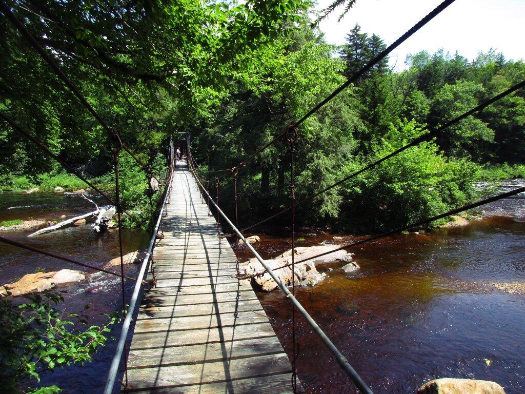
 Whitehouse Suspension Bridge

East Branch of Sacandaga River and NY 8

Interactive Map

Here is an interactive map of the campsites and trails along the East Branch of Sacandaga River.

Printable Map

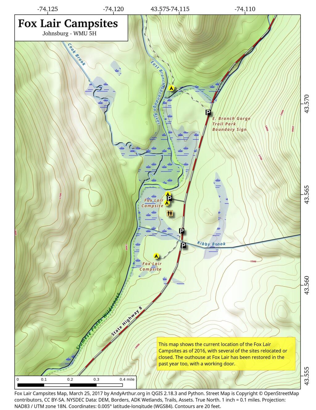
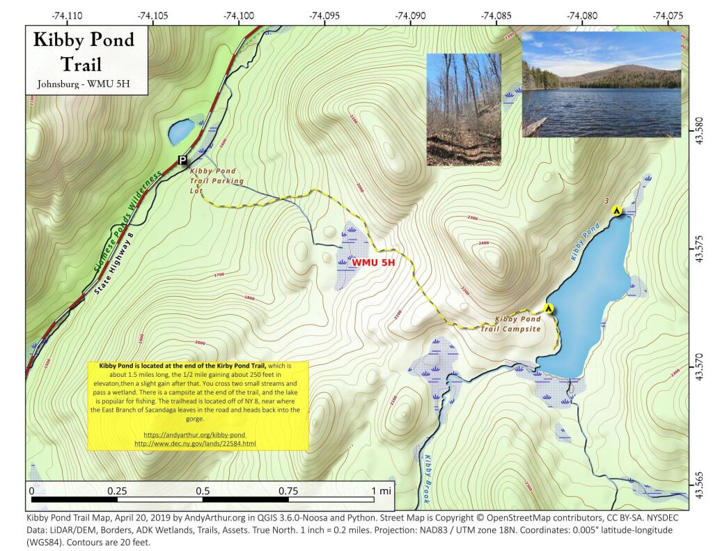
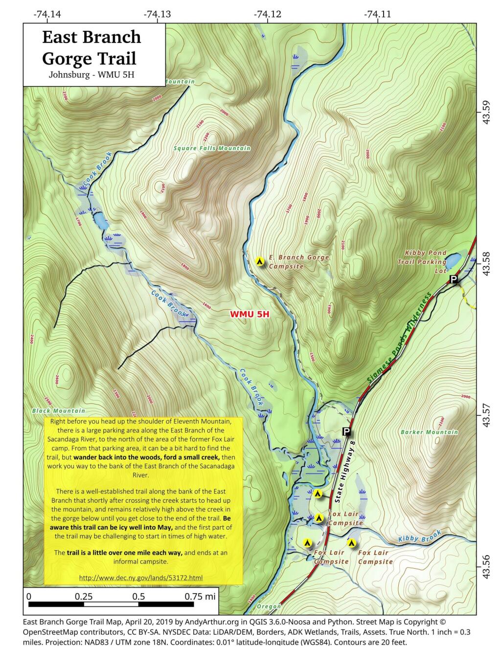
Here are several helpful printable maps.

 Fox Lair Campsites

 Kibby Pond Trail

 East Branch Gorge Trail

List and Coordinates for Campsites and Trailheads

Here is a list of campsites, trailheads and other destinations along NY 8 and East Branch Sacandaga River. You can also get this as a Google Sheets.

NameDetailsLatitudeLongitude
11th Mountain Parking LotLarge > 20 Cars43.5903782-74.0900314
11th Mountain Trailhead CampsiteNear large parking area for 11th Mountain43.5901834-74.0910822
Boulder Rock CampsiteCave-Like Site Against Large Erratic43.5384607-74.1215703
Cod Pond Parking LotMedium 5 – 20 Cars, across from campsite 7 and 843.5301580-74.1455890
Cod Pond Trail CampsiteAt end of Cod Pond trail on pond43.5176969-74.1437559
County Line Brook Trail CampsiteAlong County Line Trail43.5242772-74.1892664
County Line CampsiteEnd of County Line Trail43.5022688-74.1828085
E. Branch Gorge CampsiteEnd of East Branch George, near Waterfalls43.5803187-74.1209517
E. Branch Gorge Trail Parking AreaSmall < 5 Cars43.5690250-74.1132232
Eagle Pond CampsiteNear Eagle Pond43.5401509-74.1167243
East Sacandaga River Parking Picnic AreaDOT Maintained Roadside Parking And Picnic Area43.4783862-74.2010766
Forks Mountain Trail – Bushwhack to Auger Falls43.4685687-74.2457562
Georgia Creek Parking LotMedium 5 – 20 Cars43.4915171-74.1892866
Girrad Sugarbush Trailhead43.4764458-74.2043731
Griffin Connector Parking Lot At Route 8Medium 5 – 20 Cars43.4703209-74.2248680
Kibby Pond Campsite #3Far End of Lake43.5766649-74.0781098
Kibby Pond Trail #2End of Trail43.5725581-74.0821443
Kibby Pond Trail Parking LotSmall <5 Cars43.5789951-74.1033601
Little Joe Pond CampsiteAt Little Joe Pond43.5055662-74.1423052
Little Joe Pond Picnic Site43.5039558-74.1422817
Mud Ponds CampsiteAt Mud Point43.5650797-74.1739273
NY 8 Campsite 1Old Routing of 8, Near Kibby Pond Area43.5771279-74.1054574
NY 8 Campsite 2Overlooks Cliff43.5650960-74.1160232
NY 8 Campsite 3Long dirt road to open area43.5616391-74.1169664
NY 8 Campsite 4Dirt road to campsite above Kibby Brook43.5612062-74.1138524
NY 8 Campsite 5Old home site, sits on ledge above NY 843.5542527-74.1234025
NY 8 Campsite 71/4 mile north of Cod Pond Parking43.5328656-74.1440210
NY 8 Campsite 8Near Cod Pond Parking43.5316564-74.1459341
NY 8 Campsite 9 (Seasonal Use)Route 8 Near Little Joe Trail Pulloff With Fire Ring (Campsite Removed During Winter)43.5149220-74.1583197
NY 8 Campsite 10Gravel Pit 1/4 mile south of Girrad Sugarbush Trailhead43.4761691-74.2072253
Oregon Trail Primitive CampsiteBeyond Stewart Creek Snomwobile Bridge43.5194607-74.1339532
Parking LotMedium 5 – 20 Cars43.5355769-74.1414217
Shanty Brook Trail CampsiteAlong Shanty Brook Trail43.5460737-74.1459537
Shanty Falls Parking LotSmall <543.5376556-74.1409559
Square Falls43.5814233-74.1218099
Stewart Creek Bridge43.5204188-74.1356239
Stewart Creek Flume43.5204188-74.1356239
Stewart Creek Lower Falls43.5225332-74.1365675
Teachout Road Bridge Over Griffin Falls43.4733545-74.2236654
Teachout Road Parking at Griffin Falls43.4737995-74.2238438

Northville-Placid Trail

An interactive map of the Northville Placid Trail, featuring campsites, lean-tos and nearby trails. The Northville–Lake Placid Trail, also known as the NPT, is a lightly traveled foot trail that runs 138 miles through the Central Adirondack Park from Northville to Lake Placid. It was laid out by the Adirondack Mountain Club in 1922 and 1923 and is maintained by the New York State Department of Environmental Conservation. It is connected to Long Path to the south, which runs through the Mohawk Valley, Heldebergs, Schoharie Valley, Catskill Mountains, Shawgunks and ultimately to George Washington Bridge in New York - New Jersey.

Also available is a printable (Adobe PDF) version of the Northville Placid Trail Maps.

Campsites and Lean-To Coordinates

Here is a listing of Campsites and Lean-To Coordinates.

Trail Road Crossings:

Below is a listing where the Northville - Placid Trail crosses public roads. You can use these coordinates to help find trailheads.

Street City ZIP lng lat
1173 County Road 123 Mayfield 12117 -74.2013797 43.2041425
570 Collins Gifford Vly Northville 12134 -74.2077243 43.2138129
2003 County Road 6 Northville 12134 -74.3116965 43.2475343
2003 County Road 6 Northville 12134 -74.3123703 43.2479095
2003 County Road 6 Northville 12134 -74.4345398 43.373703
1750 State Route 8 Piseco 12139 -74.4959583799054 43.4288730112742
1730 State Route 8 Piseco 12139 -74.496949368311 43.4283456662233
471 Old Piseco Rd Piseco 12139 -74.5241317665044 43.4481265239214
471 Old Piseco Rd Piseco 12139 -74.4911075371203 43.7145566153636
471 Old Piseco Rd Piseco 12139 -74.4627270288044 43.7389165463427
8105 State Route 30 Indian Lake 12842 -74.3865506809112 43.8422133769259
8105 State Route 30 Indian Lake 12842 -74.3843450915841 43.8384297766447
8 Tarbell Hill Ln Long Lake 12847 -74.3925084093623 43.9760341326559
211 Averyville Ln Lake Placid 12946 -74.0136636120448 44.2630681820573


September 18, 2015 evening

Good evening. Currently 62 degrees at the Otter Creek Campsites in Greig, NY. There is a stiff breeze on top of the mountain that is making it feel cooler than the mercury says. The clouds and high pressure will keep the temperatures from dropping off much more.

Tomorrow the summer heat lasts for one more day, heading up to 80 degrees. Then the front comes through and temperatures will drop to 45 degrees by morning. Showers as the front comes through. Sunday will only reach 64 degrees for a high. Sunday evening will be even colder with a steady breeze. No snow is expected, and heck, the first half of autumn is shaping to mostly be above normal temperatures. I guess it’s kind of like an extra summer with short fall days.

Tonight was the first sunset before 7 PM in Delmar although out in Lowville being further west, sunset held off until 7:06 pm. It didn’t matter that much as I couldn’t see the sunset from camp. But with the clouds it was getting dark NY 7:30 PM. The lights are nice but they don’t replace the long nights of early summer.

This morning I had nothing packed but I did go grocery shopping the previous evening. The first thing I did was put the kayak on the roof of my truck, carefully with the step ladder that I bought yesterday. I had a fear of re-injuring my ankle but it was fine, if not easier with the steps tool compared to climbing on the floor boards of the cab. My ankle doesn’t hurt that much these days although I felt it by the time I got packed.

I stopped in Boonville to take a piss break and to drop a bill from the doctor at the Post Office. Nice downtown buy surprisingly bustling and a challenge to park. But then it was off to Turin and eventually to the Otter Creek Campsites.

I was pleasantly surprised that the Otter Creek Campsites had been relocated up the hill, spread out and with new outhouses, picnic tables, and fireplaces. I liked the Otter Creek Campsites because they were close to Whetstone Gulf and Lowville but didn’t like the crowded conditions or wear from heavy use. The new sites are a real improvement. Some are grouped together but the most part are spread out. There remains six sites, with three designed to be wheelchair accessible including accessible outhouses, tables, and a flat gravel base. It’s nice to know the state has developed all these accessible sites, especially if someday I have a severe injury that otherwise confines me to a wheelchair. After spraining your ankle you think about such things more.

This evening went for a drive out to Confusion Flats and out to by Chases Lake. Last time I was up here it was quite rainy and the camera quit working early on the trip before I got pictures. Took both Instagram photos and Digital SLR pictures. Confusion Flats is such beautiful Adirondack Sand Plains. The maps up here are terrible, including the topographic maps and ones created by DEC data. There are a lot of old roads and paths cut through Confusion Flats that are now horse trails, while the truck trails often differ from old routes on topographic maps and some are better quality then the Jeep Trails on the map would suggest. All of the roads up here are just sand and the frequent equestrian use means that the are pitted by horse hooves. At least horse hooves don’t damage sand like the washboard roads of Moose River Plains.

Set up a tarp so I’m prepared for tomorrow’s rain which I’m sure isn’t going to materialize with the tarp up. The Bluetooth adapter with my powered  computer speakers aka now camp speakers works great. I love being able to play on my phone while listening to music, podcasts, and radio – and change the station or song without even leaving my seat. Technology is pretty cool.

I hope you had a good evening. Sleep well.

The Cost of New York Being on the Cutting Edge

Lately there have been a lot of discussion on why New York State is such a high tax state compared to others, and why our state gets relatively little back in funding compared to other states.

The common refrains are that New York is a liberal state, so we invest a lot more in human services, healthcare, welfare and education. That is true to a certain extent. But it’s also not totally true either. Red states actually have a lot better public services then many blue staters want to believe. Another common refrain is that New York is a wealthy state, so we aren’t eligible for nearly the same amount of transfer payments are poorer states. That is also true, although New York also has plenty of pockets of poverty — but we are also the financial capital of the world and home to our nation’s biggest city. Some say corruption is worse in New York then other states. I’m a bit skeptical on that point, I think there are more watch dogs on government then other states — being a such a big state with well funded newspapers. Are Albany politicians really going to pull a fast one over on the New York Times and New York Post at the same time?

But there is another truth that is often ignored. New York often rejects a lot of federal funding. While contemporary reasons for rejecting federal funding may be ideological in nature, the original reason our state rejected federal funding was we chose to be out in front of the federal government — on canals, on highways, on parks, on forests, etc. New York chose to build a lot of it’s infrastructure without federal funding, because we built before the funding was avaliable. Being out front is good, but sometimes it’s really costly to taxpayers.

The New York State Thruway is a prime example of this. Why do people pay tolls to drive on the Thruway, while most other highways are free in New York? Because in early 1950s, the legislature decided our state needed a superhighway. Rather then wait to see if federal funding would become avaliable to build the highway, we decided to do it on our own. A cost bourne 100% by New York taxpayers. While the Adirondack Northway recieved 90% of it’s funding from the federal gas tax, the Thruway recieved 0% of it’s funding from the federal gas tax.

Now could the state have removed the toll booths and recieved federal funding for the highway for maintaince? Possiblity but not likely. The federal interstate act did not allow for grandfathering in existing routes, although some free routes did get upgrades to interstate standards under the act. Rather then eliminate the tolls and seek federal funding for the Thruway, our state has chosen to pay fror it upkeep 100% from state funding, namely tolls but also general fund revenue. If we made it eligable for federal funding, New York would also have to pick up the difference between federal funding and state funding, and it’s not always easy to find extra funding in the gas tax.

We are in the same boat with many of our state’s bridges and tunnels. Could the state have waited a few years and got funding for free crossing over the Hudson River and the New York City metropolitian crossings? Probably yes, as most of the Western States have no tolls, even on their biggest Interstate Bridges. Our state certainly could have gotten 50% of the cost of building and maintaining back on the Hudson River crossings, and 90% in some cases. But we chose to build them before federal funding was avaliable. Now we are stuck with the clunky Bridge Authorities and Triborough Authority, which pays 100% of the bridge expenses through local tolls. Even if we eliminated the tolls, it”s not clear we cold get federal funding at this point. Nor is it clear if we would want to — by refusing federal funding — our state has the “freedom” to set whatever standards it wants on the bridges, including advertising and geometery. Federal highway standards don’t apply to non-federally funded roads.

The federal government maintains locks and canals on most rivers. Our state doesn’t get to take advantage of federal maintaince to our canals. We have the Erie Canal, which is entirely paid again by state taxpayers and those who traverse the canal. We talk about Clinton’s Ditch as being a great advance for our state. It certainly was at it’s time. But we could have had the federal government build it for us had we waited a few years — and put up with the federal government’s dicates. Certainly the Army Corp or Engineers maintains a lot of the nation’s canals. But not in New York. We chose once again to go it alone on our canal system.

One could have imagined that New York City could have gotten the federal government to finance their drinking water reserviors, had that waited a little while longer, and been willing to put up with creation of a federal public authority like the Tennessee Valley Authority. Maybe New York City’s drinking water reserviors would have not only produced clean water, but also greater recreational opporunities and more hydropower had the federal government, not the city built them. But no, our state had go out in front of the federal government — a cost picked up federal government in other states.

No state in America has as big of a state operated wild forest or wilderness as New York does. That’s not saying other states don’t have great public lands that are a mixature of managed forest and wilderness, operated by the federal government. The Adirondack Park is tiny compared to some of the National Forests and Bureau of Public Lands out west. Other states also have developed parks and recreation areas, but many of them are funded and directly operated by the federal government. But not New York, bar a few small historic battle sites, and the relatively small Finger Lakes National Forest. Why not? Our state got out ahead of federal funding and furthermore rejected federal operation of our Adirondack and Catskill Parks.

New York State certainly could have been home to the Adirondack National Forest or the Adirondack National Park. But no, our state rejected that idea off-hand. Vermont decided to protect it’s wild upcountry and mountains with the Green Mountain National Forest, but not New York. Our state once again got out ahead of the federal government, and rather then create a managed forest, we were stuck in the mid-1800s line of thought that all logging was bad and we could only preserve the land by banning all timber cutting for any purposes.

By rejecting creation of a Adirondack National Forest or National Park, our state once again passed up on billions of federal funding. Rather then have the federal government pay for maintaining roads, parking areas, campsites and trails in Adirondack, New York taxpayers are 100% on the hook. The Green Mountain National Forest in contrast has federally funded forest rangers, federally funded maps and recreational facilities, federally funded campgrounds and much more. Instead, our state has chosen to take up this cost because we wanted ideological control over the land — rather let distant Washington politicians decide how to maintain the lands.

There is somewhat a myth that red states have awful public services, while blue states have a much better government. While blue states like New York are often on the cutting edge, getting out on cutting edge before the federal government means New York residents pay dearly. Forgoing federal funds by getting a decade out ahead of other states might have some short term advantages, but it often means our state residents ends up paying for a lot of other things that federal government would have otherwise paid for in coming years.