Map: NYS Metropolitian Region

Download a High Resolution JPEG Image of the NYS Metropolitian Region or an Adobe Acrobat Printable PDF of the NYS Metropolitian Region.
About Map: NYS Metropolitian Region ....
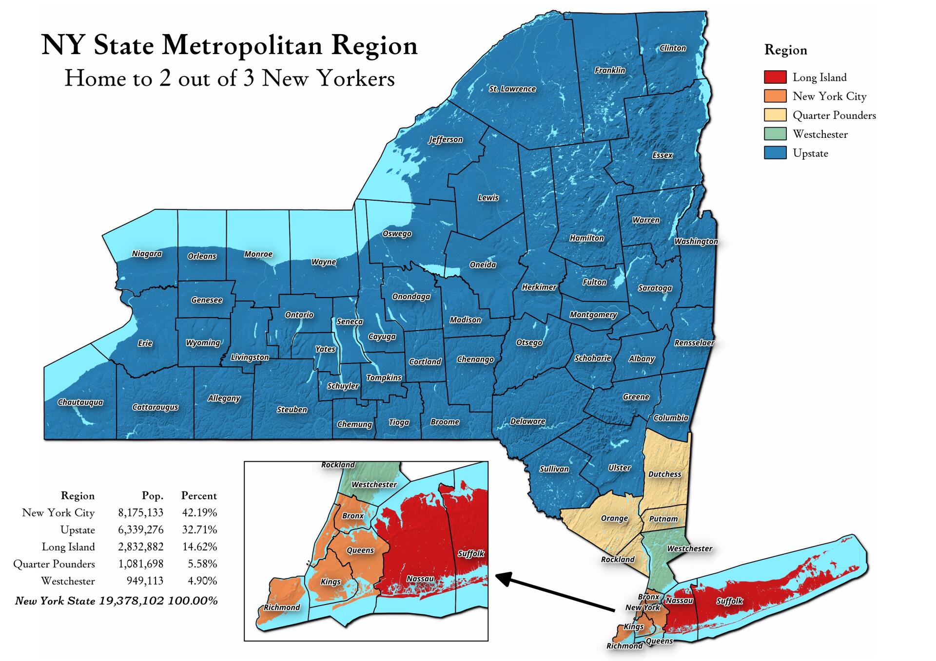
Somebody was asking about a map of the Quarter Pounders, along with Long Island, Westchester, and New York City -- versus Upstate map. This map shows this regions, along with the respective population in each region. The Quarter Pounders -- Dutchess, Orange, Putnam and Rockland Counties have this name, as they each have a quarter weighted vote on the MTA Board.

Bookmark my free Interactive GPS Map for your phone:
https://andyarthur.org/ny
... shows your location as a blue dot in relationship to campsites, trails, state land. This online map requires cell service, won't work in remote country, so also bring a paper map.
Free Download of New & Historical USGS 1:24k Topograpic Maps
Interactive maps with backcountry and roadside camping: New York, Pennsylvania, West Virginia & Vermont. List of NYS DEC Lean-Tos and Firetowers.
Google Spreadsheet with Roadside, Primitive and Pay Campsites
More about New York State...
New York is a state in the Northeastern region of the United States. New York is the 27th-most extensive, the 3rd-most populous, and the 7th-most densely populated of the 50 United States. New York is bordered by New Jersey and Pennsylvania to the south, and by Connecticut, Massachusetts and Vermont to the east. The state has a maritime border with Rhode Island east of Long Island, as well as an international border with the Canadian provinces of Ontario to the west and north, and Quebec to the north. The state of New York is often referred to as New York State to distinguish it from New York City.
Aerial Photos
Albany – A Plan for the Capital City (Downtown Albany 1980 Plan vs. Downtown Albany Today)
Albany (NY) The Battle In Lincoln Park
Albany Lumberyard (1857 vs. 2017)
Colonie Center (1952 vs. 2018)
Costcos (After vs. Before)
Crossgates 1970s (1973 vs. 1985)
Delmar Bypass (1953 vs. 2019)
Delta Lake
Dennings Point State Park
Don’t You Hate The Lack Of Parking At Colonie Center
Downtown Albany – June 12, 1951
East Syracuse and Dewitt
Enfield Glen
Esperance
Fox Lair (1942 vs. 2017)
Green Lakes State Park
High Acres Landfill
High Point in Berne (1960 vs. 2017)
Hornell
I-86 And I-390 Interchage
Karner East Barriens
Kueka Outlet
LaFarge And Port Of Coeymans
Limekiln Falls Area
Little Falls (1957 vs. 2017)
Mid-Crosstown Arterial Arbor Hill Section (1970 vs. 2016)
Middleburgh
NY 23 Past Windham High Peak
Newburgh (1969 Urban Renewal Proposal vs. Today)
Northville Quarry
Olean
Original Can of Worms vs Erie Canal (1895 vs. 1971 vs. 2020)
Photo: Adirondack Homeland Rock at Crane Pond Road
Plan for Albany 1794 (Overlay vs. Street Map)
Platte Clove
Proposed Mid-Crosstown Arterial South of Washington Park (1970 vs. 2016)
Salamanca
The Kunjamunk
Thruway Interchange 80s and 90s (1973 vs. 2018)
Tivoli Lake (1973 vs. 1995 vs. 2017)
WMS Map: Auburn Arterial
Wakely Dam (1942 vs. 2017)
Washington Avenue Extension (1973 vs. 2018)
Watkins Glen from Above Seneca Lake
White Birch Pond – Tubbs Pond – Fawn Lake (1960 vs. 2017)
White House (1942 vs. 2017)
Wolf Hill
Maps and Interactives
Zoar Valley
Young Lake
Yesterday morning for a while
Wurstboro Curve
Woodward Lake
Woods Lake
Woodman Pond and Chenango Canal
Woodland Valley – DEC Campground
Wolf Road – 1952 vs Today
Wolf Pond Trail
Winona State Forest
Winifred Matthews Holt Preserve
Windmill Interchange at Clearview and Long Island Expressway
Willie Marsh Trails
Wilds of the Tug Hill Plateau
Wilcox Lake
Wilcox Dock in April 1952
Who owns the right-of-way along Old River Road in Little Falls?
Whittaker Lake
White Rocks – Taconic Crest Trails
White House, NY
White Birch Pond
Whipporwill Corners State Forest
Whetstone Gulf
... photos, maps and other content from from New York State.