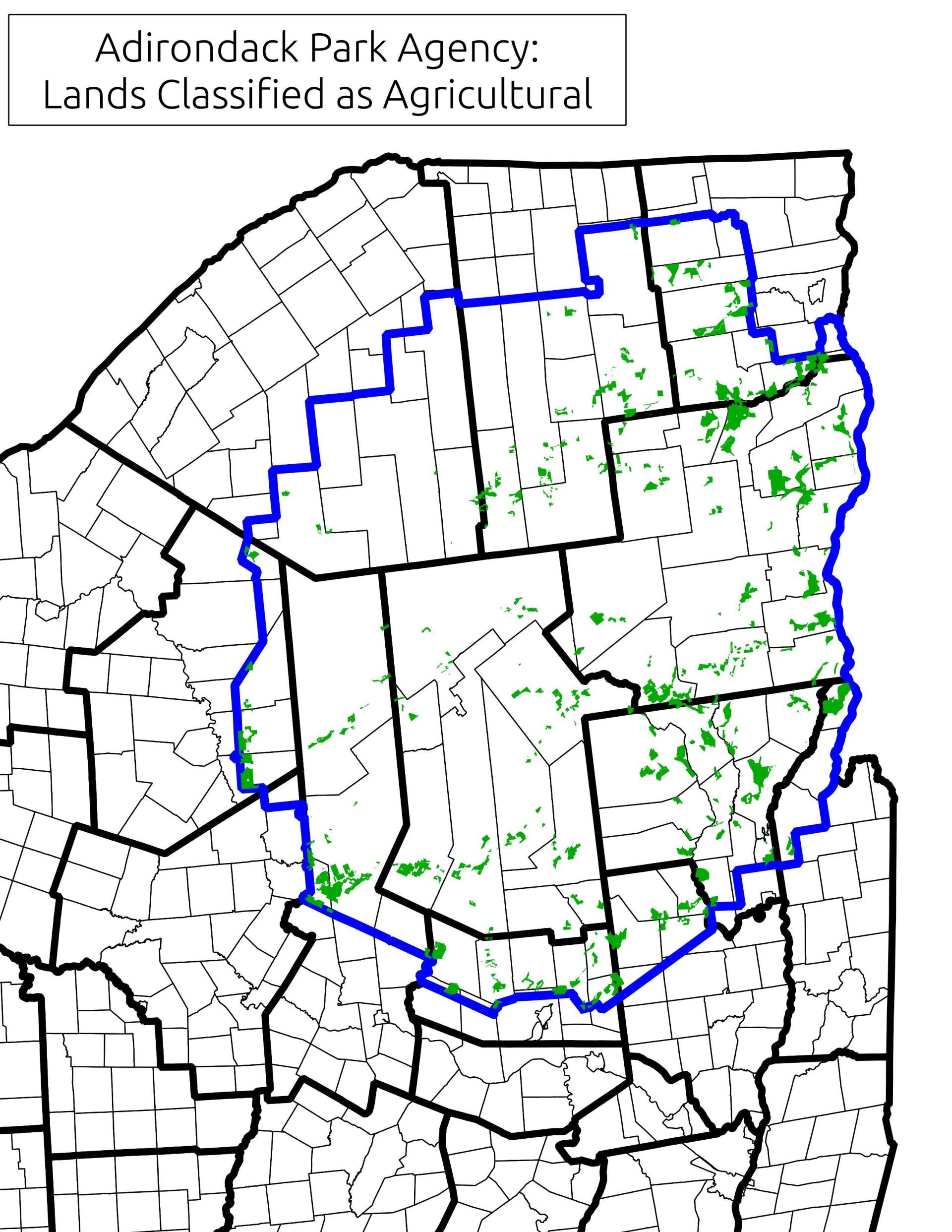
Map: Lands Classified as Agricultural By Adirondack Park Agency
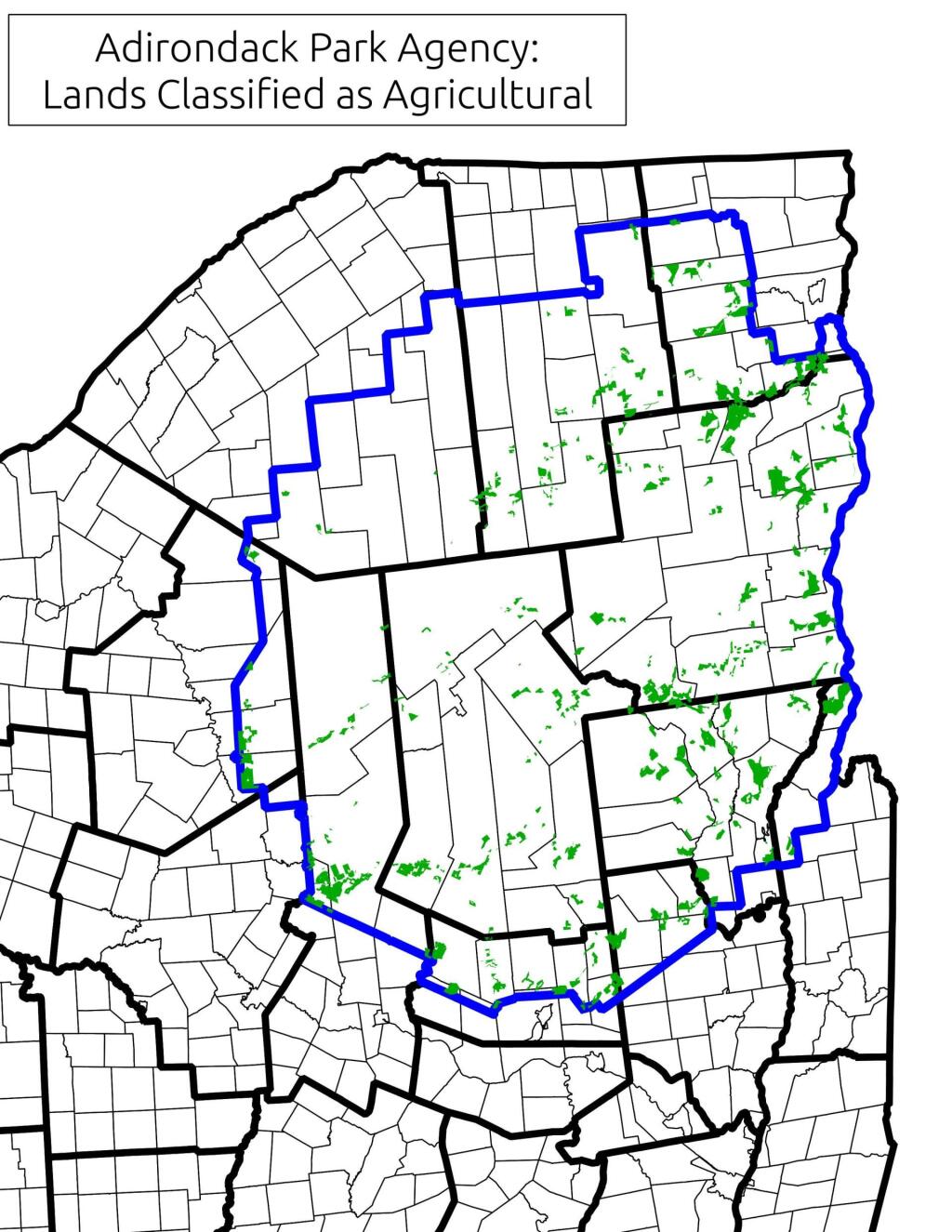
Download a High Resolution JPEG Image of the Lands Classified as Agricultural By Adirondack Park Agency or an Adobe Acrobat Printable PDF of the Lands Classified as Agricultural By Adirondack Park Agency.

Bookmark my free Interactive GPS Map for your phone:
https://andyarthur.org/ny
... shows your location as a blue dot in relationship to campsites, trails, state land. This online map requires cell service, won't work in remote country, so also bring a paper map.
Free Download of New & Historical USGS 1:24k Topograpic Maps
Interactive maps with backcountry and roadside camping: New York, Pennsylvania, West Virginia & Vermont. List of NYS DEC Lean-Tos and Firetowers.
Google Spreadsheet with Roadside, Primitive and Pay Campsites
More about Adirondacks...
The Adirondack Park is a publicly protected, elliptical area encompassing much of the northeastern lobe of Upstate New York. It is the largest park and the largest state-level protected area in the contiguous United States, and the largest National Historic Landmark. The park covers some 6.1 million acres (2.5×10⁶ ha), a land area roughly the size of Vermont and greater than the National Parks of Yellowstone, Yosemite, Grand Canyon, Glacier, and Great Smoky Mountains combined.
The Adirondack Park boundary, commonly referred to as the 'Blue Line,' contains the entire Adirondack Mountain range, as well as some surrounding areas, all within the state of New York. The park includes all of Hamilton and Essex counties, as well as considerable portions of Clinton, Franklin, Fulton, Herkimer, St. Lawrence, and Warren counties and small portions of Lewis, Oneida, Saratoga, and Washington counties as well. (The Clinton County towns of Altona and Dannemora, despite being entirely within the park boundary, are specifically excluded from the park by statute, due to the large prison facilities in both towns.)
Not all of the land within the park is owned by the state, although new sections are frequently purchased or donated. State land comprises 2.7 million acres (1.1×10⁶ ha), about 45% of the park's area, including the highest peaks in New York State, as well as Mount Marcy, the highest elevation in the state. About 1 million acres (400,000 ha) of this is classified as wilderness, with most of the remainder managed under the somewhat less stringent wild forest classification. Villages and hamlets comprise less than 1% of the area of the park; the remaining area of more than 3 million acres (1.2×10⁶ ha) is privately held but is generally sparsely developed.[3] There is often no clear demarcation between state, private, and wilderness lands in the park. Signs marking the Adirondack Park boundary can be found on most of the major roads in the region, but there are no entrance gates and no admission fee.
Maps and Interactives
Whiteface Mountain
Reber
MODIS Aqua – September 28, 2023
Kane Mountain
Jay Covered Bridge
Great November 1950 Adirondack Blowdown
Chase Lake
Cedar River at Indian River
Carver Gravel Mine
Adirondacks, September 26, 2020
Adirondack Park Land Classifications
Verplanks Adirondacks Survey with Contemporary State Lands
Spectulator Peaks
South Western Adirondacks Peaks
Adirondack Park – Distance To Buildings
Adirondack Park Wilderness Areas
Adirondack Lakes
Adirondack Forest Preserve
Adirondack Conservation Easements
Eastern NY – The Adirondacks – Green Mountains Terrian Map
Adirondack Park Watershed – Subbasins
Adirondack Park of New York
Upper Hudson Ski Loop Trail
Ok Slip Falls
Northville To West Stoney Creek – NPT
... photos, maps and other content from from Adirondacks.