Search Results for: map kibby pond trail 2
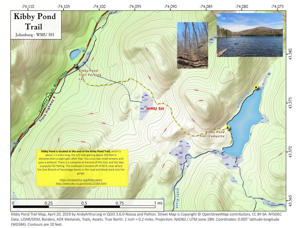
Kibby Pond Trail
East Branch of Sacandaga River and NY 8
Interactive Map
Here is an interactive map of the campsites and trails along the East Branch of Sacandaga River.
Printable Map
Here are several helpful printable maps.
List and Coordinates for Campsites and Trailheads
Here is a list of campsites, trailheads and other destinations along NY 8 and East Branch Sacandaga River. You can also get this as a Google Sheets.
| Name | Details | Latitude | Longitude |
| 11th Mountain Parking Lot | Large > 20 Cars | 43.5903782 | -74.0900314 |
| 11th Mountain Trailhead Campsite | Near large parking area for 11th Mountain | 43.5901834 | -74.0910822 |
| Boulder Rock Campsite | Cave-Like Site Against Large Erratic | 43.5384607 | -74.1215703 |
| Cod Pond Parking Lot | Medium 5 – 20 Cars, across from campsite 7 and 8 | 43.5301580 | -74.1455890 |
| Cod Pond Trail Campsite | At end of Cod Pond trail on pond | 43.5176969 | -74.1437559 |
| County Line Brook Trail Campsite | Along County Line Trail | 43.5242772 | -74.1892664 |
| County Line Campsite | End of County Line Trail | 43.5022688 | -74.1828085 |
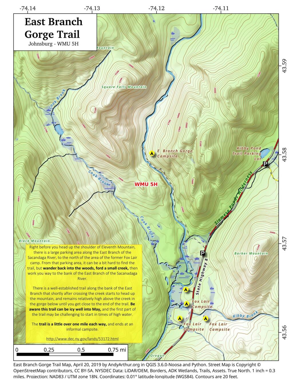
| E. Branch Gorge Campsite | End of East Branch George, near Waterfalls | 43.5803187 | -74.1209517 |
| E. Branch Gorge Trail Parking Area | Small < 5 Cars | 43.5690250 | -74.1132232 |
| Eagle Pond Campsite | Near Eagle Pond | 43.5401509 | -74.1167243 |
| East Sacandaga River Parking Picnic Area | DOT Maintained Roadside Parking And Picnic Area | 43.4783862 | -74.2010766 |
| Forks Mountain Trail – Bushwhack to Auger Falls | 43.4685687 | -74.2457562 | |
| Georgia Creek Parking Lot | Medium 5 – 20 Cars | 43.4915171 | -74.1892866 |
| Girrad Sugarbush Trailhead | 43.4764458 | -74.2043731 | |
| Griffin Connector Parking Lot At Route 8 | Medium 5 – 20 Cars | 43.4703209 | -74.2248680 |
| Kibby Pond Campsite #3 | Far End of Lake | 43.5766649 | -74.0781098 |
| Kibby Pond Trail #2 | End of Trail | 43.5725581 | -74.0821443 |
| Kibby Pond Trail Parking Lot | Small <5 Cars | 43.5789951 | -74.1033601 |
| Little Joe Pond Campsite | At Little Joe Pond | 43.5055662 | -74.1423052 |
| Little Joe Pond Picnic Site | 43.5039558 | -74.1422817 | |
| Mud Ponds Campsite | At Mud Point | 43.5650797 | -74.1739273 |
| NY 8 Campsite 1 | Old Routing of 8, Near Kibby Pond Area | 43.5771279 | -74.1054574 |
| NY 8 Campsite 2 | Overlooks Cliff | 43.5650960 | -74.1160232 |
| NY 8 Campsite 3 | Long dirt road to open area | 43.5616391 | -74.1169664 |
| NY 8 Campsite 4 | Dirt road to campsite above Kibby Brook | 43.5612062 | -74.1138524 |
| NY 8 Campsite 5 | Old home site, sits on ledge above NY 8 | 43.5542527 | -74.1234025 |
| NY 8 Campsite 7 | 1/4 mile north of Cod Pond Parking | 43.5328656 | -74.1440210 |
| NY 8 Campsite 8 | Near Cod Pond Parking | 43.5316564 | -74.1459341 |
| NY 8 Campsite 9 (Seasonal Use) | Route 8 Near Little Joe Trail Pulloff With Fire Ring (Campsite Removed During Winter) | 43.5149220 | -74.1583197 |
| NY 8 Campsite 10 | Gravel Pit 1/4 mile south of Girrad Sugarbush Trailhead | 43.4761691 | -74.2072253 |
| Oregon Trail Primitive Campsite | Beyond Stewart Creek Snomwobile Bridge | 43.5194607 | -74.1339532 |
| Parking Lot | Medium 5 – 20 Cars | 43.5355769 | -74.1414217 |
| Shanty Brook Trail Campsite | Along Shanty Brook Trail | 43.5460737 | -74.1459537 |
| Shanty Falls Parking Lot | Small <5 | 43.5376556 | -74.1409559 |
| Square Falls | 43.5814233 | -74.1218099 | |
| Stewart Creek Bridge | 43.5204188 | -74.1356239 | |
| Stewart Creek Flume | 43.5204188 | -74.1356239 | |
| Stewart Creek Lower Falls | 43.5225332 | -74.1365675 | |
| Teachout Road Bridge Over Griffin Falls | 43.4733545 | -74.2236654 | |
| Teachout Road Parking at Griffin Falls | 43.4737995 | -74.2238438 |
Camping Areas in Southern Adirondacks
Camping Areas in Southern Adirondacks ⛺
East Branch of Sacanadaga River, NY 8 – Roughly 10 campsites along NY 8. These are easily accessed throughout the year, as the road is plowed except when the snow banks are high during the winter. East Branch is not good for fishing due to wide variance in water levels, however there are some nice pools in sections of river for summer swimming. Lots of road noise. Some of the sites have cell service. Nearby locations include Cod Pond, East Branch Trail and Kibby Pond Trail.
Edick Road – There are a handful of very hidden campsites off of Edick Road. This road may be closed to vehicles due to wash outs autumn 2019, but worth a walk to explore this area.
Fawn Lake – A 1/2 mile hike back to a scenic lake ringed by primitive campsites outside of Lake Pleasant. Two miles beyond it is the scenic Willis Vly, which doesn’t have developed campsites but it’s remote wilderness where you might see a Moose or other wildlife.
Garnet Lake – Tent sites, some with drive-up access along the lake. No cell service, much of the upper road here is not maintained in the winter. Popular in the summer, no cell service.
Good Luck Lake – Scenic lake off of the West Branch Sacanadaga River that is ringed with tent sites that can be walked in from the Good Luck Lake parking area area or paddled in.
Hope Falls Road – Two or three campsites along the end of Hope Falls Road, some are drive-in only tent sites. Near the Tenant Creek Falls Trail. No cell service. Open June to autumn snowfall.
Harrisburg Road – There is a set of very rustic designated campsites along the rough Harrisburg Road past Harrisburg Lake. Somewhat near Crane Mountain, a couple mile hike to and Wilcox Lake. No cell service.
Lester Flow and Cheney Pond – Scenic lake that is popular for paddling. The 1/2 mile road down from Boreas Road as of June 2020 is closed due to washouts. Tent sites exist along the lake, along with one drive-to site on the road down there.
Mason Lake – Small lake located about 10 miles north of Speculator and 5 miles south of Lewey Lake that has several tent and drive-in campsites along it’s shore. Good to fair cell service here. Nice to hear loons, one of the best bass ponds in the area.
North Lake Reservoir – There are roughly 15 campsites on the east shore of North Lake Reservoir. Popular place in the summer, regularly staffed by conservation students. Noise from motorboats. No cell service. Nice if you want to camp right on water, hear loons at night..
Northwood Club Road – In Minerva, this road crosses the Boreas River and has several roadside campsites, and passes by Huntley Pond, the NL Tahawus Railroad (which can be hiked to the Boreas River at Hudson River), and the Blue Ledges on the Hudson tailhead.
Perkins Clearing – Conservation easement lands. Good to fair cell service here. Great place for hunting and wildlife observation as it’s mixed timber country. Near Mason Lake, Speculator, Pillsbury Mountain and Cedar Lakes.
Piseco-Powley Road – A dozen campsites along a 13 mile road with short hikes including Big Alderbed, House Pond, Sand Lake and the popular Potholers/Brayhouse Brook waterfall for swimming. As of June 2020, road is closed in Stratford/Fulton County portion, road is open north of Potholers/Brayhouse Brook (access via Piseco). Very limited cell service here.
Pumpkin Hollow Road – Three campsites above Willis Lake. Remote country except for the site on Willis Lake, no cell service. On the Willis – Wilcox Lake Trail. Very quiet area. Open June to autumn snowfall. No cell service here.
Rockwood State Forest – Three campsites along the end of Church Road which can be accessed by driving past the cemetery in the hamlet. Scenic lake, good fishing. Cell service available, but bring a trash bucket and gloves as litter can be a problem. Nice trails to stroll around in the old Rockwood Estate.
Stewart Landing – There are four campsites on a rough road that loops off of Stewart Landing Road. Popular area in the summer, Canada Lake is great for paddling and informal swimming. Also consider hiking back to Hilderbrandt Vly and Glassgow Lake from here. Moderate to poor cell service here.
Vanderwhacker Road -Five or six campsites exist along Vanderwhacker Road, which can be muddy in the spring and icy in late autumn. Additional designates campsites exist near where NY 28N crosses the Vanderwhacker River. Near the trail to the Vanderwhacker Firetower, No cell service.
White House, Wells – A grouping of 5 or 6 campsites at the end of White House in West River Road. Scenic area, old camp, with fields and a chimney. Campsites are kind of close together, not a wilderness experience. Near the North Country Placid Trail, lots of blueberries in mid-summer. No cell service. Open June to autumn snowfall.
Woodhull Lake Reservoir – Off of NY 28 in McKeevers, about 10 miles south of Old Forge. Not only is this beautiful reservoir to paddle, there are some campsites along the shore, with drive-to campsites along Wolf Lake Landing Road which leads to it. Part of Wolf Lake Landing Road is erroded, but other parts are fresh stone-dust. It’s remote wilderness but there good cell service in mcuh of the area.