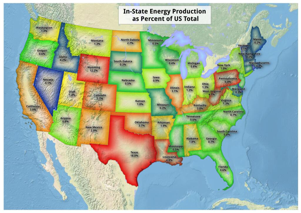
Map: In State Energy Production As Percent Of US Total
Download a High Resolution JPEG Image of the In State Energy Production As Percent Of US Total or an Adobe Acrobat Printable PDF of the In State Energy Production As Percent Of US Total.

Bookmark my free Interactive GPS Map for your phone:
https://andyarthur.org/ny
... shows your location as a blue dot in relationship to campsites, trails, state land. This online map requires cell service, won't work in remote country, so also bring a paper map.
Free Download of New & Historical USGS 1:24k Topograpic Maps
Interactive maps with backcountry and roadside camping: New York, Pennsylvania, West Virginia & Vermont. List of NYS DEC Lean-Tos and Firetowers.
Google Spreadsheet with Roadside, Primitive and Pay Campsites
More about Energy...
Maps and Interactives
Warren Generating Station 1993
Uranium Mine
United Refining
Terra Satellite – May 1, 2010 – Deep Water Horizon Spill
Shepards Solar Farm
Pilgrim Nuclear Plant
Oil Wells in New York State
Nature Conservancy Lands in New York State
Mars Hill, Maine
Major Oil Storage Facilities
Lindytown Coal Mine
John E. Amos Power Plant
Hydrofracked Natural Gas Well, versus Empire Plaza
Houses with Coal Heat in the Southern Tier
Hartsfield Ferry Coal Plant
Harford Mills Brine Storage Ponds
Hancock Shaker Village Surrounded by Industrial Solar Facilities
Grandview Wind Farm
Gina Nuclear Plant ⚛
DG Bethlehem Solar West – A One Megawatt Industrial Solar Facility
Coal mining, Southern Ohio
Centralia, PA
Buildings Heated with Geothermal in New York
Buildings Built in NYS Since 2015 that Heat with Natural Gas
Brunner Island Power Station
... photos, maps and other content from from Energy.