Search Results for: map hill higher state forest 2
USGS Topographic Maps – Albany to Delaware Counties
Counties: Albany to Delaware / Dutchess to Livingston / Madison to Otsego / Putnam to Suffolk / Sullivan to Yates
Browse Topographic Maps: Full State / Historical USGS Topographic Maps
Albany County


Allegany County


Bronx County


Broome County


Cattaraugus County


Cayuga County


Chautauqua County


Chemung County


Chenango County


Clinton County


Columbia County


Cortland County


Delaware County


State Truck Trails and Forest Preserve Roads Over A Half Mile
Looking for state land to wheel on? This list shows all of the conservation department-maintained DEC truck trails and public access roads that are more then a 1/2 mile long. This roads are varied, but most of them are dirt roads that take you through the back country. Town maintained roads through state forests are generally not shown on in this listing.
| State Land | Road | Miles |
|---|---|---|
| Albert J. Woodford Memorial State Forest | Truck Trail | 0.7 |
| Albert J. Woodford Memorial State Forest | Janis Road | 1.1 |
| Aldrich Pond Wild Forest | Powell Road | 0.5 |
| Aldrich Pond Wild Forest | Mullins Flow Road | 0.6 |
| Aldrich Pond Wild Forest | Little River Road | 0.7 |
| Aldrich Pond Wild Forest | Silver Dawn Road | 0.7 |
| Aldrich Pond Wild Forest | Jackworks Trail | 1.1 |
| Aldrich Pond Wild Forest | South Creek Lake Road | 1.6 |
| Aldrich Pond Wild Forest | Tyler Road | 3.7 |
| Aldrich Pond Wild Forest | Streeter Lake Road | 4.8 |
| Allen Lake State Forest | George Forest Road | 1.5 |
| Ambler State Forest | Truck Trail | 1.8 |
| Ampersand Primitive Area | Ampersand Park Road | 3.2 |
| Andersen Hill State Forest | Big Pine Public Forest Acess Road | 1.5 |
| Arctic China State Forest | China Public Forest Access Road | 1.1 |
| Arctic China State Forest | Shears Public Forest Access Road | 2 |
| Arctic China State Forest | Dunbar Public Forest Access Road | 2.1 |
| Armlin Hill State Forest | Truck Trail | 1.1 |
| Arnold Lake State Forest | Public Forest Access Road | 0.9 |
| Arnold Lake State Forest | Hartwick Forest Access Road | 1 |
| Ashland Pinnacle State Forest | Ashland Pinnacle Access Road #2 | 0.5 |
| Ashland Pinnacle State Forest | Haul Road #1/Long Path Hiking Trail | 1.4 |
| Avon Regional Office | Goodlake Year Entrance Road | 0.7 |
| Baker School House State Forest | Baker School House Public Forest Acess Road | 1.8 |
| Bald Mountain State Forest | Howe Forest Road | 2.4 |
| Balsam Creek State Forest | Briar Hill Road | 1.5 |
| Barbour Brook State Forest | Barbour Brook Public Forest Access Road | 2 |
| Basswood State Forest | Burlington Public Forest Access Road | 0.5 |
| Basswood State Forest | Basswood Pond Public Forest Access Road | 1 |
| Basswood State Forest | Dr. Crouch Truck Trail | 1.3 |
| Bates State Forest | Pucker Street | 1 |
| Bates State Forest | Bates Forest Road | 2.6 |
| Battle Hill State Forest | Unnamed | 1.3 |
| Bear Pond Primitive Area | Bear Pond Road | 0.8 |
| Bear Swamp State Forest | Karsch Haul Road | 0.5 |
| Bear Swamp State Forest | Joe Chamberlin Public Forest Access Road | 1.6 |
| Bear Swamp State Forest | Roseboom Public Facility Truck Trail | 1.8 |
| Bear Swamp State Forest | Snowmobile Trail | 8.3 |
| Bearpen Mountain State Forest | Ski Run Road | 2.1 |
| Beartown State Forest | Town Road | 0.7 |
| Beartown State Forest | Cotton Road | 0.8 |
| Beartown State Forest | Steam Mill Road | 0.8 |
| Beartown State Forest | Aspen Hollow Road | 2.4 |
| Beaver Creek State Forest | Public Forest Access Road 2, Madison 11 | 0.5 |
| Beaver Creek State Forest | Truck Trail -2-12 | 0.7 |
| Beaver Creek State Forest | Public Forest Access Road 1, Madison 11 | 1.3 |
| Beaver Creek State Forest | Truck Trail -1-12 | 3.6 |
| Beaver Dam State Forest | Sears Public Forest Acess Road | 1.4 |
| Beaver Meadow State Forest | Weir Dam Truck Trail | 0.5 |
| Beebe Hill State Forest | Barrett Pond Road | 1.4 |
| Beebe Hill State Forest | Loop Road | 2.3 |
| Big Brook State Forest | County Line Road Spur | 0.6 |
| Big Brook State Forest | Walasek Mulcoy Road | 0.8 |
| Big Brook State Forest | Hanifin Road | 0.9 |
| Big Brook State Forest | County Line Road | 1.4 |
| Birdseye Hollow State Forest | Sanford Lake Access Road | 0.5 |
| Black Creek State Forest | Stanley Road | 1.1 |
| Black River Wild Forest | Remsen Falls Trail | 0.5 |
| Black River Wild Forest | Woods Lake Road | 0.5 |
| Black River Wild Forest | Gull Lake Road | 0.6 |
| Black River Wild Forest | Flansburg Road | 0.7 |
| Black River Wild Forest | Party Road | 0.7 |
| Black River Wild Forest | Black Creek Road | 0.8 |
| Black River Wild Forest | Cohen Road | 1.7 |
| Black River Wild Forest | Flansberg Road | 2.6 |
| Black River Wild Forest | Black Creek Lake Road | 3 |
| Black River Wild Forest | Haskell Road | 3 |
| Black River Wild Forest | Mill Creek Road | 3.4 |
| Black River Wild Forest | Nicks Lake Campground Roads | 3.5 |
| Black River Wild Forest | Wolf Lake Landing Road | 4.8 |
| Black River Wild Forest | West Creek Road | 6.3 |
| Blenheim Hill State Forest | Ward Allen Road | 1.1 |
| Blenheim Hill State Forest | Quarry Road | 1.2 |
| Blue Mountain Wild Forest | Deer Pond Road | 1.1 |
| Blue Mountain Wild Forest | Chain Lakes Road North | 1.3 |
| Blue Mountain Wild Forest | Polaris Road | 1.3 |
| Bombay State Forest | Cross Haul Road | 0.7 |
| Bombay State Forest | Railroad Bed Public Forest Acess Road | 1.2 |
| Bombay State Forest | Pike Brook Haul Road | 3.1 |
| Bonaparte’s Cave State Forest | Corbine Road | 0.8 |
| Bonaparte’s Cave State Forest | Mud Pond Road | 0.8 |
| Boutwell Hill State Forest | Arab Hill Forest Road, Cha 1 Section | 0.8 |
| Boutwell Hill State Forest | Arab Hill Forest Road, Cha 7 Section | 2.1 |
| Boyce Hill State Forest | Jackson Forest Road | 0.6 |
| Brasher State Forest | Route 53 Haul Road | 0.5 |
| Brasher State Forest | Beaver Pond Trail | 0.6 |
| Brasher State Forest | Kennehan Haul Road | 0.8 |
| Brasher State Forest | Bush Road | 1.1 |
| Brasher State Forest | Buckley Haul Road | 1.2 |
| Brasher State Forest | Cc Dam Public Forest Access Road | 1.2 |
| Brasher State Forest | Mccarthy Public Forest Access Road | 1.6 |
| Brasher State Forest | Liberty Public Forest Access Road | 1.7 |
| Brasher State Forest | Hastings Falls Haul Road | 2.1 |
| Brasher State Forest | Wilson Public Forest Access Road | 2.1 |
| Brasher State Forest | Camp / Larue Public Forest Access Road | 2.2 |
| Brasher State Forest | Pascal Haul Road | 2.4 |
| Brasher State Forest | Bush Public Forest Access Road | 2.9 |
| Brasher State Forest | Railroad Bed Public Forest Access Road | 3.6 |
| Brokenstraw State Forest | Brokenstraw Forest Road | 1.7 |
| Bryant Hill State Forest | Hawk Forest Road | 1.4 |
| Buck Hill State Forest | Hertz Road | 0.7 |
| Buck Hill State Forest | Truck Trail | 1.5 |
| Buck Hill State Forest | Buck Hill Road | 3.1 |
| Bucks Brook State Forest | Access Trail | 0.6 |
| Buckton State Forest | Buckton Haul Road | 0.8 |
| Bucktooth State Forest | Baily Hollow Forest Road | 0.6 |
| Bucktooth State Forest | Manley Hill Forest Road | 1 |
| Bully Hill State Forest | Dixon Forest Road | 1 |
| Bully Hill State Forest | Connection Forest Road | 1.6 |
| Bully Hill State Forest | Stearns Forest Road | 2.1 |
| Burnt-Rossman Hills State Forest | Koenig Road | 0.5 |
| Burnt-Rossman Hills State Forest | Betty Brook Haul Road | 0.6 |
| Burnt-Rossman Hills State Forest | Eminence Dead End Truck Trail | 0.7 |
| Burnt-Rossman Hills State Forest | Duck Pond Road | 1.2 |
| Burnt-Rossman Hills State Forest | Monkey Run Truck Trail East | 1.3 |
| Burnt-Rossman Hills State Forest | Yankee Street Truck Trail | 1.3 |
| Burnt-Rossman Hills State Forest | Betty Brook Road | 1.4 |
| Burnt-Rossman Hills State Forest | Betty Brook Truck Trail | 1.5 |
| Burnt-Rossman Hills State Forest | Duck Pond Truck Trail | 1.5 |
| Burnt-Rossman Hills State Forest | Morey Road Truck Trail | 1.7 |
| Burnt-Rossman Hills State Forest | Eminence Road Truck Trail | 2.6 |
| Burnt-Rossman Hills State Forest | Burnt Hill Road | 2.9 |
| Bush Hill State Forest | Fox Cross Forest Road | 2 |
| California Hill State Forest | Wayawanda Road | 0.7 |
| Canacadea State Forest | Macduff Road | 2.3 |
| Canadaway Creek Wma | Dibble Hill Forest Road | 2 |
| Canaseraga State Forest | Ringelberg Truck Trail | 0.5 |
| Canaseraga State Forest | Right Fork Truck Trail | 1 |
| Canaseraga State Forest | Stanley Road | 1.1 |
| Canaseraga State Forest | Left Fork Truck Trail | 1.4 |
| Caroga Lake Campground | Campground Road | 2 |
| Catherineville State Forest | Santamont Access Trail | 1.1 |
| Catherineville State Forest | Circle Public Forest Access Road | 1.8 |
| Charles E. Baker State Forest | Truck Trail 5 | 0.6 |
| Charles E. Baker State Forest | Truck Trail 2 | 0.9 |
| Charles E. Baker State Forest | Truck Trail 6 | 0.9 |
| Charles E. Baker State Forest | Truck Trail 4 | 1.4 |
| Charles E. Baker State Forest | Truck Trail 12 | 1.5 |
| Charles E. Baker State Forest | Truck Trail 8 | 1.9 |
| Charles E. Baker State Forest | Truck Trail 7 | 2.1 |
| Charles E. Baker State Forest | Truck Trail 1 | 3 |
| Charles E. Baker State Forest | Truck Trail 13 | 3.2 |
| Chazy Highlands State Forest | Spring Road | 0.6 |
| Cherry Valley State Forest | Kniskern Public Access Road | 1.2 |
| Cherry Valley State Forest | Mosse Public Forest Access Road | 1.9 |
| Cinnamon Lake State Forest | Hornby Road Haul Road | 0.7 |
| Clapper Hollow State Forest | Clapper Hollow Truck Trail | 1 |
| Clark Hill State Forest | Abandoned Town Road | 0.8 |
| Clark Hill State Forest | Truck Trail | 0.9 |
| Clark Hill State Forest | Access Road North Of Buck Hill Road | 0.9 |
| Clark Hill State Forest | Class A Truck Trail | 1.2 |
| Clark Hill State Forest | Haul Road | 1.3 |
| Cliffside State Forest | Railroad Haul Road | 1.3 |
| Cobb Brook State Forest | Unnamed Truck Trail | 0.6 |
| Cold Creek State Forest | Headwaters Forest Road | 1.4 |
| Cold Spring Brook State Forest | Cold Spring Brook Public Forest Access Road | 1.9 |
| Cole Hill State Forest | Cr 2 Access Road | 0.8 |
| Coyle Hill State Forest | Warner Spur Forest Road | 0.5 |
| Coyle Hill State Forest | Slawson Forest Road | 0.8 |
| Coyle Hill State Forest | Warner Forest Road | 1.8 |
| Cranberry Lake Campground | Campground Road | 2.5 |
| Cranberry Lake Wild Forest | Grass River Railroad | 6.1 |
| Cuyler Hill State Forest | Jipson Hill Public Forest Acess Road | 1.3 |
| Cuyler Hill State Forest | Cuyler Hill Public Forest Acess Road | 5.1 |
| David A. Sarnoff Preserve | Field Access Road | 0.8 |
| Debar Mountain Wild Forest | Debar Game Refuge Road | 0.5 |
| Debar Mountain Wild Forest | Debar Meadow Road | 0.6 |
| Debar Mountain Wild Forest | Vanderwalker Road | 0.9 |
| Debar Mountain Wild Forest | 4 Mile Road Riffle Season Access Corridor | 1.1 |
| Debar Mountain Wild Forest | Ny Centrail Railroad Bed | 2.2 |
| Deer River State Forest | Ccc Road | 0.6 |
| Deer River State Forest | Hogsback Road | 0.6 |
| Deer River State Forest | Willow Road | 0.6 |
| Deer River State Forest | Glaze Road | 0.7 |
| Deer River State Forest | Avery Lot Road | 0.9 |
| Deer River State Forest | Esseltine Hill Road | 0.9 |
| Deer River State Forest | Ricky’s Number Trail | 1 |
| Deer River State Forest | Horse Barn Road | 1.2 |
| Deer River State Forest | Laramie Road | 1.3 |
| Deer River State Forest | Beanville Road | 1.4 |
| Deer River State Forest | Spruce Road | 1.6 |
| Deer River State Forest | Loope Road | 2 |
| Deer River State Forest | Firewood Road | 2.6 |
| Degrasse State Forest | Burns Flats Road | 0.5 |
| Degrasse State Forest | Loop Road | 1.2 |
| Deruyter State Forest | Tromp Road | 1.5 |
| Dobbins Memorial State Forest | Snowmobile Trail | 3.5 |
| Dog Hollow State Forest | Brewer Public Forest Acess Road | 0.9 |
| Downerville State Forest | River Public Forest Access Road | 1 |
| Dry Run State Forest | Wildcat Hollow | 0.8 |
| Dunkin’s Reserve State Forest | Access Road | 3.5 |
| Dutch Settlement State Forest | Haul Road #1 | 0.6 |
| Dutton Ridge State Forest | Dutton Ridge Access Road | 1.5 |
| Earlville State Forest | Mad 2 Forest Access Road | 1.5 |
| East Osceola State Forest | Malloy Brook Road | 1.1 |
| East Otto State Forest | Kriedeman Forest Road | 1.7 |
| Edgewood Oak Brush Plains Preserve | Edgewood Oak Brush Plains Preserve | 0.5 |
| Edgewood Oak Brush Plains Preserve | Unpaved Forest Road | 0.5 |
| Edgewood Oak Brush Plains Preserve | Old Commack Road | 1.6 |
| English Hill State Forest | Ricketts Forest Road | 0.9 |
| Exeter State Forest | Exeter Public Forest Access Road | 1.3 |
| Fairfield State Forest | Jenksville Hill Public Forest Acess Road | 2 |
| Fall Brook State Forest | Gossner Road | 0.6 |
| Fall Brook State Forest | Haul Road To B-45 Wetland | 0.9 |
| Fall Brook State Forest | Access Road From Co. Rt 67A | 1 |
| Fall Brook State Forest | Forest Access Roaad | 1.2 |
| Ferris Lake Wild Forest | Meco Lake Trail | 0.9 |
| Ferris Lake Wild Forest | Sheriff Lake Trail | 0.9 |
| Ferris Lake Wild Forest | Mud Lake Road | 5.5 |
| Fish Creek State Forest | Forward Road | 0.5 |
| Fish Creek State Forest | Trestle Road | 0.6 |
| Fish Creek Wma | State Highway 184 Access Road | 0.9 |
| Five Rivers Education Center | Goose Lane | 0.5 |
| Flat Rock State Forest | Pedobo Road | 0.8 |
| Flat Rock State Forest | Karsch Haul Road | 0.9 |
| Flat Rock State Forest | Ampersand Park Road | 1.9 |
| Florence Hill State Forest | Florence Hill Road | 1.9 |
| Fort Jackson State Forest | Sheldon Public Forest Access Road | 0.5 |
| Frank E. Jadwin Memorial State Forest | Keesler Road | 0.6 |
| Frank E. Jadwin Memorial State Forest | Old Croghan Road | 0.7 |
| Frank E. Jadwin Memorial State Forest | Henry Road | 0.8 |
| Frank E. Jadwin Memorial State Forest | Nelson Road | 0.8 |
| Frank E. Jadwin Memorial State Forest | Wahalula Road | 0.8 |
| Frank E. Jadwin Memorial State Forest | Q- Road | 1.5 |
| Frank E. Jadwin Memorial State Forest | Patchin Road | 1.7 |
| Frank E. Jadwin Memorial State Forest | Blanchard Creek Road | 2.7 |
| Frank E. Jadwin Memorial State Forest | Wisner Road | 2.7 |
| Frank E. Jadwin Memorial State Forest | Judy Cole Road | 2.8 |
| Frank E. Jadwin Memorial State Forest | Loop Road | 3.2 |
| Fulton Chain Wild Forest | Cary Lake Road | 1.8 |
| Furnace Creek State Forest | Miller Road East | 0.7 |
| Furnace Creek State Forest | Powerline Row | 0.7 |
| Furnace Creek State Forest | Sheehan Road | 1.2 |
| Furnace Creek State Forest | B-29 Road | 1.4 |
| Gates Hill State Forest | Coons Den Truck Trail | 0.6 |
| Gates Hill State Forest | Eviann Road | 1.2 |
| Genegantslet State Forest | South Loomis Road | 0.7 |
| Gillies Hill State Forest | Abbey Forest Road | 0.9 |
| Gillies Hill State Forest | Pettit Forest Road | 1.4 |
| Golden Hill State Forest | Firelane Forest Road | 1.6 |
| Goundry Hill State Forest | Guiren Road | 1 |
| Goundry Hill State Forest | Corbett Hollow Access Road | 1.1 |
| Grant Powell State Forest | Huck Berry Road | 2.1 |
| Grass River Wild Forest | Spruce Mountain Road | 0.8 |
| Grass River Wild Forest | Hollywood Road | 2.5 |
| Grass River Wild Forest | Railroad Grade Road | 2.9 |
| Greenwood Creek State Forest | Grass Pond Public Forest Access Road | 0.9 |
| Grigg’s Gulf State Forest | Grigg’s Gulf Public Forest Acess Road | 1.5 |
| Gulf Unique Area | Gulf R.O.W. Road | 0.5 |
| Gulf Unique Area | Old Skid Road | 1.1 |
| Hall Island State Forest | Unnamed Public Forest Acess Road | 0.7 |
| Hammond Hill State Forest | Redman Run Public Forest Acess Road | 1.1 |
| Hammond Hill State Forest | Cannan Public Forest Acess Road | 1.3 |
| Hammond Pond Wild Forest | Paynes Way | 0.7 |
| Harris Hill State Forest | Sprague Forest Road | 0.8 |
| Harvey Mountain State Forest | Harvey Mt Access Road | 0.9 |
| Harvey Mountain State Forest | East Hill Access Road | 2.4 |
| Hatch Creek State Forest | Hodge Forest Road | 0.6 |
| Hatch Creek State Forest | North Forest Road | 0.8 |
| Hatch Creek State Forest | South Forest Road | 0.9 |
| Hemlock-Canadice State Forest | South Hemlock Access Road | 0.7 |
| Henderson Shores Unique Area | Radar Road | 0.8 |
| Hewitt State Forest | Hewitt Rd | 1.1 |
| Hickok Brook Multiple Use Area | Spur Road | 0.7 |
| Hickok Brook Multiple Use Area | Main Road | 1.1 |
| High Flats State Forest | Chapel Hill Access Trail | 0.5 |
| High Flats State Forest | Crowley Access Trail | 0.5 |
| High Flats State Forest | Close Pond Access Trail | 0.7 |
| High Flats State Forest | Donovan Public Forest Access Road | 1.1 |
| High Knob State Forest | Shale Pit Road | 1.9 |
| High Peaks Wilderness | Northville-Placid Trail-Northern Terminus | 1.1 |
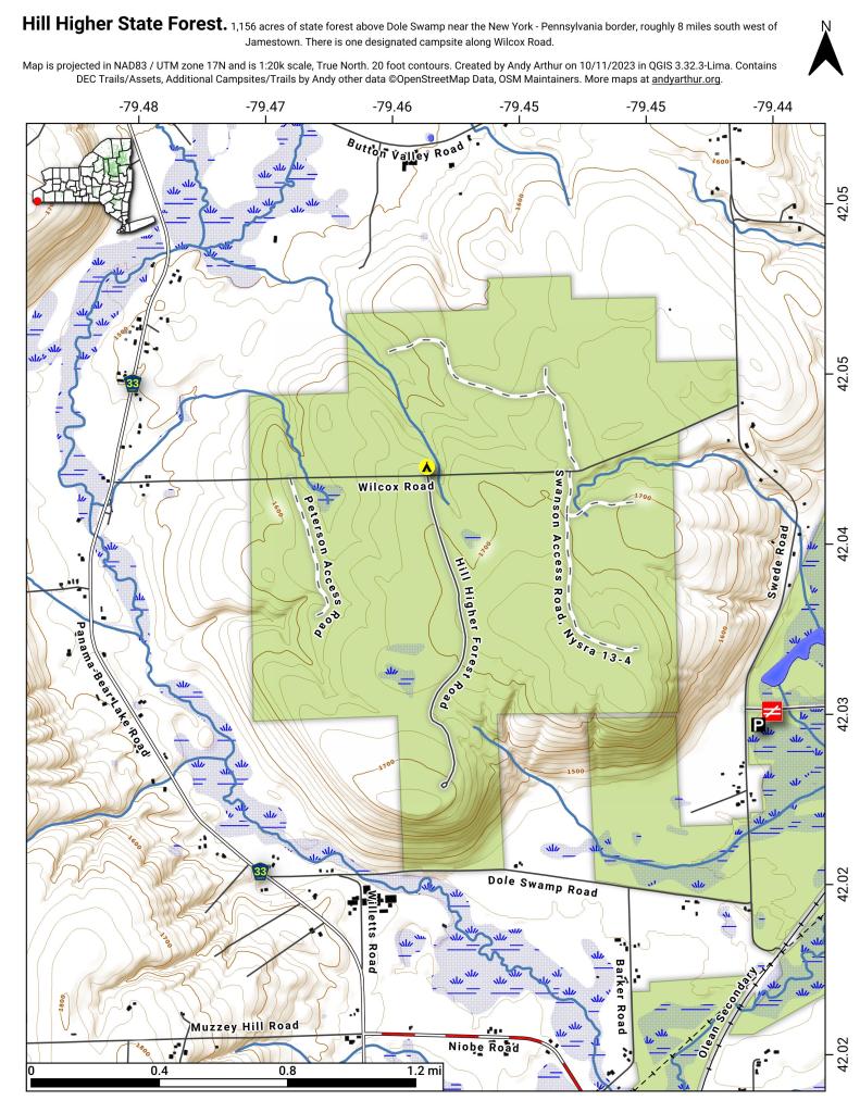
| Hill Higher State Forest | Hill Higher Forest Road | 1.1 |
| Hinckley State Forest | Elm Flats Road | 0.5 |
| Hinckley State Forest | Roberts Road | 0.5 |
| Hinckley State Forest | Lanning Road | 0.8 |
| Hinckley State Forest | Access Road | 1.6 |
| Hinckley State Forest | Black Creek Road | 2 |
| Hogsback State Forest | Forest Access Road | 3 |
| Honey Hill State Forest | Edwards Public Forest Access Road | 1.4 |
| Hooker Mountain State Forest | Norton Public Forest Access Road | 0.8 |
| Horseshoe Lake Wild Forest | Cut Off Road | 0.6 |
| Horseshoe Lake Wild Forest | Lower Dam Road | 0.7 |
| Horseshoe Lake Wild Forest | Otter Brook Trail | 0.9 |
| Horseshoe Lake Wild Forest | Grass River Railroad | 1.7 |
| Horseshoe Lake Wild Forest | Otter Brook Road | 2.2 |
| Hoxie Gorge State Forest | Russel Hill Public Forest Acess Road | 2.5 |
| Huntersfield State Forest | Huntersfield Access Road #2 | 0.7 |
| Huntersfield State Forest | Huntersfield Access Road #1 | 1.9 |
| Hunts Pond State Forest | Truck Trail | 1.7 |
| Independence River State Forest | Assembly Road | 1 |
| Independence River Wild Forest | Blue Jog Road | 0.5 |
| Independence River Wild Forest | Sunday Lake Road | 0.5 |
| Independence River Wild Forest | Evies Pond Road | 0.7 |
| Independence River Wild Forest | Burnt Creek Road | 0.7 |
| Independence River Wild Forest | Elbow Rd | 0.7 |
| Independence River Wild Forest | Shortcut Road | 0.8 |
| Independence River Wild Forest | Fish Pond Road | 1 |
| Independence River Wild Forest | Halfmoon Lake Rd | 1 |
| Independence River Wild Forest | Little Otter Creek Road | 1 |
| Independence River Wild Forest | Long Pond Spur | 1 |
| Independence River Wild Forest | East Loop Road | 1.1 |
| Independence River Wild Forest | Copper Lake Road | 1.2 |
| Independence River Wild Forest | Necessary Dam Road | 1.2 |
| Independence River Wild Forest | Pitcher Pond Road | 1.3 |
| Independence River Wild Forest | Hinchings Pond Road | 1.8 |
| Independence River Wild Forest | Basket Factory Road | 2.1 |
| Independence River Wild Forest | Catspaw Lake Road | 2.4 |
| Independence River Wild Forest | Confusion Flats Road | 2.6 |
| Independence River Wild Forest | Big Otter Lake Road | 3.1 |
| Independence River Wild Forest | Stony Lake Road | 3.1 |
| Independence River Wild Forest | Florence Pond Road | 3.1 |
| Independence River Wild Forest | Steam Mill Road | 3.5 |
| Independence River Wild Forest | Smith Road | 3.7 |
| Indian Pipe State Forest | Dunes Road | 0.7 |
| Indian River Wma | Red Lake Road | 2 |
| Jackson Hill State Forest | Forest Access Road | 2.1 |
| Jersey Hill State Forest | Scholes Forest Road | 1.6 |
| Jessup River Wild Forest | Lake Colby Camp Road | 0.7 |
| Karr Valley Creek State Forest | Frungillo Forest Road | 0.8 |
| Karr Valley Creek State Forest | Norton Forest Road | 1.3 |
| Karr Valley Creek State Forest | Davison Forest Road | 1.4 |
| Keeney Swamp State Forest | Fitch Hill Spur Forest Road | 0.7 |
| Keeney Swamp State Forest | C3D | 0.8 |
| Keeney Swamp State Forest | Fitch Hill Forest Road | 1.2 |
| Keeney Swamp State Forest | Gordon Forest Road | 1.4 |
| Kennedy State Forest | Courtney Hill Public Forest Acess Road | 0.7 |
| Kennedy State Forest | Cotton-Hanlon Public Forest Acess Road | 1 |
| Kennedy State Forest | Kennedy Public Forest Acess Road | 2.5 |
| Kenneth Wilson Campground | Campground Road | 9.7 |
| Ketchumville State Forest | Ketchumville Public Forest Acess Road | 1 |
| Keyserkill State Forest | Guinea Road Truck Trail | 1 |
| Keyserkill State Forest | Keyserkill Truck Trail #1 | 1.3 |
| Klipnocky State Forest | Emery Forest Road | 1.2 |
| Klipnocky State Forest | Marble Forest Road | 1.6 |
| Klondike State Forest | Klondike Public Forest Acess Road | 1.7 |
| Lafayetteville Multiple Use Area | Wilbur Flats Road | 0.9 |
| Lake Durant Campground | Scott Public Forest Acess Road | 0.9 |
| Lake George Wild Forest | Jabe Pond Road | 1 |
| Lake George Wild Forest | Dacy Clearing Road | 1.6 |
| Lake George Wild Forest | Lily Pond Road | 2.1 |
| Lake George Wild Forest | Gay Pond Road | 4 |
| Lake Harris Campground | Campground Road | 0.9 |
| Lakeview Marsh Wma | Skinner Road | 0.7 |
| Leonard Hill State Forest | Leonard Hill Access Road #1 | 0.7 |
| Leonard Hill State Forest | Leonard Hill Access Road #3 | 1.2 |
| Leonard Hill State Forest | Leonard Hill Access Road #2 | 1.6 |
| Lesser Wilderness State Forest | Gomer Hill Road | 0.5 |
| Lesser Wilderness State Forest | Toole Road | 0.6 |
| Lesser Wilderness State Forest | Alguire Road | 0.7 |
| Lesser Wilderness State Forest | Smith Road | 0.8 |
| Lesser Wilderness State Forest | Nob Road | 0.9 |
| Lesser Wilderness State Forest | Seelman Road | 1.3 |
| Lesser Wilderness State Forest | Mcgoldrick Road | 3 |
| Lesser Wilderness State Forest | #9 Road | 4.7 |
| Limekiln Lake Campground | Lime Kiln Lake Campground Trails | 3.9 |
| Linda Gronlund Memorial At Barcelona Neck | Trustee Road West | 1 |
| Linda Gronlund Memorial At Barcelona Neck | Trustee Road East | 1.7 |
| Lonesome Bay State Forest | Alamogin Public Forest Access Road | 2.2 |
| Long Pond State Forest | Access Road | 0.5 |
| Long Pond State Forest | Truck Trail | 0.7 |
| Long Pond State Forest | Long Pond Snowmobile Trail | 0.8 |
| Lookout State Forest | Ball Road | 0.6 |
| Lost Nation State Forest | Brookdale Road / Jenkins Corners Rd / Red Barn Rd | 2.5 |
| Lost Valley State Forest | Lost Valley Haul Road | 1.2 |
| Lowville Demonstration Area | Dadville Road | 0.6 |
| Ludlow Creek State Forest | Trail Road | 1.3 |
| Lutheranville State Forest | Access Road #1 | 0.5 |
| Lutheranville State Forest | Access Road #2 | 1.2 |
| Lyon Brook State Forest | Lyon Brook Truck Trail | 1.2 |
| Mad River State Forest | Thompson Corners Florence Road | 0.5 |
| Mad River State Forest | Bartlett Road | 0.6 |
| Mad River State Forest | Rehm Road | 0.6 |
| Mad River State Forest | Phalen Road South | 1.9 |
| Mad River State Forest | Mcspirit Road | 2.1 |
| Madawaska Flow – Quebec Brook Primitive Area | Benz Pond Road | 2.2 |
| Mallet Pond State Forest | Cemetery Road Truck Trail | 2 |
| Maxon Creek State Forest | Pease Hill Public Forest Acess Road | 1 |
| Mccarthy Hill State Forest | Main Access Road | 0.5 |
| Mccarty Hill State Forest | Ccc Forest Road | 1.5 |
| Mccarty Hill State Forest | Mccarty Hill East Forest Road | 2 |
| Mcdonough State Forest | Ccc Trail | 1 |
| Mcdonough State Forest | Truck Trail 4 | 1.1 |
| Mcdonough State Forest | Finger Lakes Trail | 1.8 |
| Mcdonough State Forest | Truck Trail 3 | 2 |
| Melondy Hill State Forest | Public Forest Access Road | 2.5 |
| Montrose Point State Forest | Through Trail | 0.6 |
| Moose River Plains Wild Forest | Loop Road | 1.2 |
| Moose River Plains Wild Forest | Indian Lake Road | 3.4 |
| Moose River Plains Wild Forest | Otter Brook Road | 3.4 |
| Moose River Plains Wild Forest | Rock Dam Road | 4.2 |
| Moose River Plains Wild Forest | Lime Kiln Lake – Cedar River Road | 16.9 |
| Morgan Hill State Forest | Herlihy Haul Road | 0.6 |
| Morgan Hill State Forest | Keith Gutchess Haul Road | 0.7 |
| Morrow Mountain State Forest | Mollie Road | 2.8 |
| Mount Hunger State Forest | Whalen Road | 0.6 |
| Mount Pisgah State Forest | Mt Pisgah Access Road #1 | 1.3 |
| Mount Pleasant State Forest | Beck Forest Road | 0.6 |
| Mount Pleasant State Forest | Brumagin Forest Road | 0.7 |
| Mount Pleasant State Forest | Spruce Forest Road | 0.8 |
| Mount Tom State Forest | Notch Lane Access Road | 1.4 |
| Mount Tom State Forest | Shaker Hollow Access Trail | 1.4 |
| Muller Hill State Forest | Davenport Road | 1.4 |
| Muller Hill State Forest | Bliss Road | 1.5 |
| New Forge State Forest | New Forge Access Road #2 | 0.5 |
| New Forge State Forest | New Forge Access Road #3 | 0.6 |
| New Forge State Forest | New Forge Access Road | 1.5 |
| Newfield State Forest | Irish Hill Haul Road | 0.8 |
| Nicks Lake Campground | Nicks Lake Campground Roads | 0.6 |
| Nimham Mountain Multiple Use Area | Coles Mills Road | 0.7 |
| Nimham Mountain Multiple Use Area | Tower Road | 0.7 |
| Nine Mile Creek State Forest | North Nine Mile Town Road | 0.5 |
| Nine Mile Creek State Forest | Phearsdorf Forest Road | 0.5 |
| Nine Mile Creek State Forest | North Nine Mile Forest Road | 2.2 |
| North Harmony State Forest | Snake Forest Road | 0.9 |
| North South Lake Campground | South Lake Road | 1.3 |
| North South Lake Campground | North Lake Campground Road | 1.8 |
| Northhampton Beach Campground | Campground Road | 5.5 |
| Oakley Corners State Forest | Oakley Corners North Public Forest Acess Road | 1.6 |
| Ohissa State Forest | Cramers Corner Road | 0.8 |
| Onjebonge State Forest | Lime Quarry Road | 1.3 |
| Onjebonge State Forest | Alice Coffey Road | 2.5 |
| Orebed Creek State Forest | Ritz Road | 1.3 |
| Ossian State Forest | Back Road To Rattlesnake | 0.7 |
| Ossian State Forest | Scoville Access Road | 1 |
| Ossian State Forest | Linzy Road Truck Trail | 1.8 |
| Otselic State Forest | Truck Trail | 3.1 |
| Otsquago State Forest | Wagner Hill Road | 0.8 |
| Otter Creek State Forest | Eatonville Road | 0.6 |
| Otter Creek State Forest | Mikes Road | 1.2 |
| Otter Creek State Forest | Otter Creek Road | 1.5 |
| Palmer’s Pond State Forest | Geitner Forest Road | 0.7 |
| Palmer’s Pond State Forest | Palmer’s Pond Forest Road | 1.5 |
| Palmer’s Pond State Forest | 6 | 2.4 |
| Partridge Run Wma | Boys Camp Road Ext | 2 |
| Patria State Forest | Pleasant Valley Road | 0.6 |
| Patria State Forest | Barkman Road Access | 0.6 |
| Patria State Forest | Hardscrabble Road Access | 0.8 |
| Peck Hill State Forest | Swamp Road | 0.5 |
| Peck Hill State Forest | West Boundary Trail | 0.6 |
| Peck Hill State Forest | Beaver Vly | 0.7 |
| Peck Hill State Forest | Dam Road | 0.7 |
| Penn Mountain State Forest | Star Hill Road | 1 |
| Penn Mountain State Forest | West Gate Road | 2.6 |
| Penn Mountain State Forest | South Gate Road | 3.6 |
| Penn Mountain State Forest | East Gate Road | 3.8 |
| Perch River Wma | Perch Lake Road | 0.5 |
| Perch River Wma | Buckminster Road | 0.9 |
| Perch River Wma | Cook Road | 1.4 |
| Perch River Wma | Allen Road | 2.1 |
| Perch River Wma | State Route 12 | 2.6 |
| Perch River Wma | Vaadi Road | 3 |
| Perch River Wma | Dog Hill Road | 4 |
| Pharsalia Woods State Forest | Nine Mile Truck Trail Snowmobile Trail | 1.6 |
| Piermont Marsh Tidal Wetland | Piermont Pier Access Road | 0.9 |
| Pine Hill State Forest | Bundy Hollow Public Forest Access Road | 1 |
| Pittstown State Forest | State Fire Lane | 2.2 |
| Plainfield State Forest | Hughes Public Forest Access Road | 1.3 |
| Plattekill State Forest | Mountain Brook Road | 1 |
| Plumbottom State Forest | Reddy Forest Road | 3 |
| Point Peninsula Wma | Pine Woods Road | 1.5 |
| Point Peninsula Wma | Beach Road | 2.1 |
| Point Peninsula Wma | Shore Road | 8 |
| Point Rock State Forest | Egger Brrok Raod | 1.3 |
| Popple Pond State Forest | Smith Road | 0.7 |
| Popple Pond State Forest | Haul Road Shared By Oneida 6 And County Forest | 1.6 |
| Popple Pond State Forest | Truck Trail | 3 |
| Potato Hill State Forest | Blackman Hill Rd | 1.1 |
| Potato Hill State Forest | Level Green Rd | 1.2 |
| Pulpit Rock State Forest | Watson Road | 0.6 |
| Punkeyville State Forest | Irish Settlement Road | 0.7 |
| Punkeyville State Forest | River Road | 0.9 |
| R Milton Hick Memorial State Forest | Lafleuer Road | 1.2 |
| Relay State Forest | Relay Public Forest Access Road | 1.2 |
| Rensselaerville State Forest | Kenyon Road Access | 2.4 |
| Ridge Conservation Area And Maintenance Center | Mid-Island Access Road | 0.5 |
| Rock City State Forest | Salamanca Forest Road | 0.8 |
| Rock City State Forest | Eckert Forest Road | 0.9 |
| Rock City State Forest | Little Rock City Forest Road | 2 |
| Rock Creek State Forest | Admin Access Road | 1.3 |
| Rockwood State Forest | Spring Road | 0.5 |
| Rockwood State Forest | B Road | 0.6 |
| Rocky Point Pine Barrens State Forest | Accessible | 0.5 |
| Rocky Point Pine Barrens State Forest | Firestone Road | 1.7 |
| Rural Grove State Forest | Rural Grove Access Road (Shibley Road) | 3.1 |
| Rush Creek State Forest | C2-C | 1.2 |
| Rush Creek State Forest | Russell Forest Road | 3 |
| Sacandaga Campground | Sacandaga Campground | 1.4 |
| Salmon River State Forest | Harpers Ferry Public Forest Acess Road | 0.9 |
| Sand Flats State Forest | Bucks Corners Road | 0.9 |
| Sand Flats State Forest | Obrian Road | 0.9 |
| Sand Flats State Forest | Water Hole Road | 1 |
| Sand Flats State Forest | Y Road | 1.5 |
| Sand Flats State Forest | Powell Road | 1.7 |
| Sand Flats State Forest | Fall Brook Road | 2.2 |
| Saranac Lakes Wild Forest | Horseshoe Pond Trail | 0.5 |
| Saranac Lakes Wild Forest | Little Clear Pond Road | 0.5 |
| Saranac Lakes Wild Forest | Connery Pond Road | 0.6 |
| Saranac Lakes Wild Forest | Little Green Pond Road | 0.6 |
| Saranac Lakes Wild Forest | Rollins Pond Access Road | 0.8 |
| Saranac Lakes Wild Forest | Medow Pond Truck Trail | 0.9 |
| Saranac Lakes Wild Forest | Bartlett Carry Road | 1.2 |
| Saranac Lakes Wild Forest | Floodwood Mountain Road | 1.2 |
| Saranac Lakes Wild Forest | Rat Pond Road | 1.5 |
| Saranac Lakes Wild Forest | Sunday Pond Road | 1.6 |
| Scott Patent State Forest | Scott Patent Access Road | 1.4 |
| Shawangunk Ridge State Forest | Woods Road | 1 |
| Shindagin Hollow State Forest | Ekroos Public Forest Acess Road | 1.4 |
| Skyline Drive State Forest | Skyline Drive Public Forest Acess Road | 2.2 |
| Slader Creek State Forest | Oberdorf Forest Road | 2.1 |
| Sonyea State Forest | Shaker Access Road | 1.9 |
| South Bradford State Forest | Ccc Road | 1.6 |
| South Hill State Forest | South Hill Truck Trail | 0.5 |
| South Hill State Forest | Public Forest Access Road Extension | 0.9 |
| South Hill State Forest | South Hill Public Forest Access Road | 0.9 |
| South Hill State Forest | Kotary Road Extension | 1 |
| South Hill State Forest | Powerline Road | 1 |
| South Mountain State Forest | Ashland Pinnacle Access Road #2 | 0.5 |
| South Mountain State Forest | South Mountain Access Road | 0.9 |
| South Mountain State Forest | Bluebird Road | 1.1 |
| South Valley State Forest | Phillips Brook Fr First Section | 0.7 |
| South Valley State Forest | Phillips Brook Forest Road | 1.2 |
| St. Regis River State Forest | Old Railroad Bed | 1.6 |
| Stammer Creek State Forest | Sugar Bush Haul Road | 1.1 |
| Steam Mill State Forest | Zion Public Forest Access Road #2 | 0.5 |
| Steam Mill State Forest | Glass House Hill Road | 1 |
| Steam Mill State Forest | Assembly Road | 1.1 |
| Steam Mill State Forest | Steammill Rd | 1.4 |
| Steam Mill State Forest | Carroll Hill Public Forest Access Road #2 | 1.9 |
| Steam Mill State Forest | Zion Public Forest Access Road #1 | 2 |
| Steam Mill State Forest | Carroll Hill Public Forest Access Road #3 | 2.5 |
| Stewart State Forest | Great Swamp Road | 0.5 |
| Stewart State Forest | Drakes Ln | 0.6 |
| Stewart State Forest | Orlando Dr | 0.6 |
| Stewart State Forest | Ridge Road South | 0.6 |
| Stewart State Forest | Scofield Lane | 0.7 |
| Stewart State Forest | Armstrong Lane Trail | 0.9 |
| Stewart State Forest | Giles Road | 0.9 |
| Stewart State Forest | Pittman Robertson Pond Road | 0.9 |
| Stewart State Forest | Weed Road | 1.2 |
| Stewart State Forest | Beaver Pond Road | 1.3 |
| Stewart State Forest | Barron Road | 1.8 |
| Stewart State Forest | Barron Road South 208 | 1.8 |
| Stewart State Forest | Ridge Road | 2.8 |
| Stewart State Forest | Maple Ave | 3.1 |
| Stewart State Forest | New Road | 3.4 |
| Stockton State Forest | Blackman Forest Road | 1.4 |
| Stone Store State Forest | Fawn Ridge Road | 2.7 |
| Sugar Hill State Forest | Firetower Access Road | 0.5 |
| Sugar Hill State Forest | Old Westerfield Road | 0.5 |
| Sugar Hill State Forest | A Trail | 1 |
| Sugar Hill State Forest | Pine Knob Road | 1 |
| Sugar Hill State Forest | Maple Lane | 2.1 |
| Summer Hill State Forest | Snowmobile Trail | 5 |
| Sundown Wild Forest | South Mountain Extension | 1 |
| Swancott Hill State Forest | Tower Road | 2.3 |
| Swancott Mill State Forest | Swancott Mill Road | 0.9 |
| Taconic Hereford Multiple Use Area | Pirate Crrek | 0.5 |
| Taconic Hereford Multiple Use Area | Whatchamacallit | 0.5 |
| Taconic Hereford Multiple Use Area | Camp | 0.6 |
| Taconic Hereford Multiple Use Area | Mercury | 0.6 |
| Taconic Hereford Multiple Use Area | Border Trail | 0.8 |
| Taconic Hereford Multiple Use Area | Mustang | 0.8 |
| Taconic Hereford Multiple Use Area | Outer Gut | 0.8 |
| Taconic Hereford Multiple Use Area | Brockway Road | 0.9 |
| Taconic Hereford Multiple Use Area | Green Acres | 1.2 |
| Taconic Hereford Multiple Use Area | Tsp Road | 1.2 |
| Taconic Hereford Multiple Use Area | Pond Gut Road | 1.3 |
| Taconic Hereford Multiple Use Area | Timbuktu | 1.3 |
| Taconic Hereford Multiple Use Area | Fong’s Way | 1.4 |
| Taconic Hereford Multiple Use Area | Getaway | 1.9 |
| Taconic Hereford Multiple Use Area | Upper Snowmobile Trail | 1.9 |
| Taconic Ridge State Forest | Rounds Mountain Rd. | 0.8 |
| Taconic Ridge State Forest | Robinson’s Hollow Road | 0.9 |
| Taconic Ridge State Forest | Green Hollow Access Road | 1.1 |
| Taylor Creek State Forest | T Road Public Forest Access Road | 1 |
| Taylor Valley State Forest | Seacord Hill Spur Public Forest Acess Road | 0.9 |
| Taylor Valley State Forest | Seacord Hill Public Forest Acess Road | 2.1 |
| Taylor Valley State Forest | Mount Roderick Public Forest Acess Road | 4.3 |
| Terry Mountain State Forest | Lynch Mt Road Trail | 1 |
| Terry Mountain State Forest | Red Road | 1.7 |
| Terry Mountain State Forest | Mud Pond Road Trail | 2 |
| Terry Mountain State Forest | Tower Road | 2 |
| Texas Hill State Forest | M8 Access Trail | 0.6 |
| Texas Hill State Forest | Texas Hill Truck Trail | 0.7 |
| Texas School House State Forest | New Lisbon Public Forest Access Road | 1.2 |
| Three Springs State Forest | Three Springs Access Road | 1.6 |
| Tied Lake Primitive Area | Tied Lake Road | 1.2 |
| Titusville Mountain State Forest | Lee Road | 2 |
| Tomannex State Forest | Tomannex Public Forest Access Road | 1 |
| Tomannex State Forest | Haul Road #1 | 4.7 |
| Toothaker Creek State Forest | Garrison Access Trail | 1.1 |
| Tri-County State Forest | Flanagan Road | 0.5 |
| Trout Lake State Forest | Cedar Lake Public Forest Access Road | 0.5 |
| Tug Hill State Forest | Home Run Road | 0.6 |
| Tug Hill State Forest | Babbit Road | 0.8 |
| Tug Hill State Forest | Gruntley Road | 1.3 |
| Tug Hill State Forest | Mile Strip Road | 2.5 |
| Tug Hill State Forest | Denning (West) Road | 2.8 |
| Tug Hill State Forest | Willams Road | 2.9 |
| Tug Hill State Forest | Horace Forward Road | 3.3 |
| Tug Hill Wma | Alphabet Lane Road | 0.8 |
| Tug Hill Wma | Runing George Road | 1.3 |
| Tug Hill Wma | Beech Street Road | 1.7 |
| Tug Hill Wma | Running George Road | 3.8 |
| Tuller Hill State Forest | Snyder Hill Public Forest Acess Road | 1.6 |
| Tuller Hill State Forest | Pipeline Public Forest Acess Road | 1.6 |
| Tuller Hill State Forest | Vinnedge Public Forest Acess Road | 1.7 |
| Turkey Hill State Forest | Turkey Hill Public Forest Acess Road | 1.3 |
| Turkey Ridge State Forest | Turkey Road | 0.7 |
| Turnpike State Forest | Turnpike Forest Road | 2.2 |
| Turnpike State Forest | Stewart Forest Road | 3.1 |
| Upper And Lower Lakes Wma | Canton Access Road | 0.5 |
| Upper And Lower Lakes Wma | Logging Access Road | 0.5 |
| Upper And Lower Lakes Wma | Corning Access Road | 1 |
| Upper And Lower Lakes Wma | Middle Access Road | 1.2 |
| Vandermark State Forest | Allen Forest Road | 1.1 |
| Vandermark State Forest | Bird Forest Road | 1.5 |
| Vanderwhacker Mountain Wild Forest | Cheney Pond Road | 0.5 |
| Vanderwhacker Mountain Wild Forest | Thilo Road | 1.7 |
| Vanderwhacker Mountain Wild Forest | Vanderwhacker Road | 2.6 |
| Watson’s East Triangle Wild Forest | Wolf Creek Road West | 0.5 |
| Watson’s East Triangle Wild Forest | Deep Cuts Road | 0.6 |
| Watson’s East Triangle Wild Forest | Tunnel Road | 0.7 |
| Watson’s East Triangle Wild Forest | Number 1 Road | 2.1 |
| Watson’s East Triangle Wild Forest | Bear Pond Road | 8.4 |
| Webster Hill State Forest | Webster Hill Forest Access Road | 0.8 |
| West Canada Lake Wilderness | Northville-Placid Trail | 2.2 |
| West Parishville State Forest | Scotch Pine Access Trail | 0.5 |
| West Parishville State Forest | Red Pine Access Trail | 0.7 |
| West Parishville State Forest | Kidney Killer Access Trail | 0.9 |
| Whalen Memorial State Forest | Whalen Forest Road | 1.6 |
| Whaupaunaucau State Forest | Haul Road #4 | 0.5 |
| Whaupaunaucau State Forest | Alguire Road | 1 |
| Whaupaunaucau State Forest | C8 – B15 Road | 1.3 |
| Whippoorwill Corners State Forest | Loop Access Road | 1.3 |
| Whiskey Flats State Forest | Capell Access Road | 0.5 |
| Whiskey Flats State Forest | Sochia Pond Public Forest Access Road | 0.5 |
| Whiskey Flats State Forest | Sandy Public Forest Access Road | 0.7 |
| White Pond Multiple Use Area | Farmers Mills Road | 0.9 |
| White Pond Multiple Use Area | White Pond Road | 1 |
| Wilcox Lake Wild Forest | Dorr Road | 0.5 |
| Wilcox Lake Wild Forest | Lizard Pond Road | 0.6 |
| Wilcox Lake Wild Forest | Mud Pond Road | 0.7 |
| Wilcox Lake Wild Forest | Fish Ponds Road | 0.8 |
| Wilcox Lake Wild Forest | Harrisburg Lake Road | 1.5 |
| Wilcox Lake Wild Forest | Pumpkin Hollow Road | 1.5 |
| Wilcox Lake Wild Forest | Oregon Road | 1.7 |
| Wilcox Lake Wild Forest | West Stony Creek Road | 5.4 |
| Wiley Brook State Forest | Finger Lakes Trail | 0.7 |
| William C. Whitney Wilderness | Lake Lila Road | 5.8 |
| Wilson Hill Wma | Sand Road | 0.6 |
| Wilson Hill Wma | Northern Access Road | 1.9 |
| Winona State Forest | Blood Road | 0.7 |
| Winona State Forest | Hessel Road | 0.9 |
| Winona State Forest | Remington | 1.1 |
| Winona State Forest | Hawley Road | 1.5 |
| Winona State Forest | Tucker Road | 2.6 |
| Winona State Forest | Bargy (Main) Road | 3.2 |
| Wolf Lake State Forest | Orbegezo Row | 1.4 |
| Woodland Valley Campground | Woodland Valley Road | 0.5 |
| Woodland Valley Campground | Camping Trail Road | 0.8 |
| Yatesville Falls State Forest | Yatesville Falls Access Road | 1.2 |
Looking for state land to wheel on? This list shows all of the conservation department-maintained DEC truck trails and public access roads that are more then a 1/2 mile long. This roads are varied, but most of them are dirt roads that take you through the back country. Town maintained roads through state forests are generally not shown on in this listing.
June 16, 2017 9 AM Update
Good morning! It is about 61 degrees under cloudy skies with a few sprinkles as I walked down to the Park and Ride this morning. More rain expected later, I don’t expect it to get much about 69 degrees today. I think I just beat the rain walking down to the express bus. I’m sure it will be wetter soon, based on the radar. I did bring my rain coat for later. Much hotter come Saturday, although I’m not expecting much of a washout for the weekend.
The sun will set at 8:35 pm with dusk around 9:10 pm, which is 21 seconds later than yesterday. At sunset, look for mostly cloudy conditions and 65 degrees. The dew point will be 62 degrees. There will be a south-southeast breeze at 8 mph. Today will have 15 hours and 18 minutes of daytime, an increase of 17 seconds over yesterday.
Tonight will have a chance of showers. Patchy fog after 2am. Otherwise, mostly cloudy, with a low of 61 degrees at 4am. Four degrees above normal. Maximum dew point of 62 at 6pm. South wind 3 to 8 mph. Chance of precipitation is 30%. New precipitation amounts of less than a tenth of an inch possible. In 2016, it got down to 56 degrees with mostly sunny skies. The record low of 44 occurred back in 1954.
Got home and watched the PBS Newshour Live last night. It was actually a much more informative coverage tonight, rather then just gore and sex appeal. Maybe they didn’t obligated to cover flashy stories tonight, and got more into the meat of the serious policy discussions going on, and our president’s continuing ethical problems.
The rain stopped and I walked down to the library. Started making up some maps but didn’t get real far on that. Maybe more tonight. Ended up watching a video on one of the farming channels that I follow on Youtube. It’s just quite interesting all of the things and technologies that farmers nowadays use to produce food and fiber.
Then I got watching videos on off-grid cabins and mini-houses. In part because I’ve gotten into 12 volt wiring, and in part because I hate how overly complicated and energy wasteful modern housing, I’m just fascinated by the technology. I would rather own more land and much less house, and be able to manage my energy generation and consumption myself, along with water and waste disposal. I’m not somebody who loses much sleep about a piece of plastic wrapper tossed into a fire, especially compared to the multi-national owned landfills that are corporate alternative. Fresh eggs are good too.
Sat out back for a while playing on my phone and doing some reading. My truck accessory battery has kept a good charge all week, despite using the fan quite a bit and the truck cap lights. LED lighting technology is quite energy efficient, and the fan doesn’t use that much power. By the low voltage disconnect protecting against battery abuse, I am also allowing the battery to charge quicker and not become damaged. The next time I go driving somewhere, the charge in the accessory battery will be fully restored.
On this day in 1911, IBM founded as the Computing-Tabulating-Recording Company in Endicott, New York. Today it’s continuing to create jobs in the form of environmental remediation for all the hazardous solvents that leaked out of the chip manufacturing plants in Endicott, poisoning many families drinking water in the region. Technology is the gift that keeps giving in the form of toxic byproducts. God only knows how much toxic chemicals are leaking out at the SUNY NanoTech laboratories in the Albany Pine Bush, but we can guess even the smartest scientists only have a hint of what nasties they are releasing into the air and water.
Looking ahead, there are 4 weeks until National Nude Day when the sun will be setting at 8:31 pm with dusk at 9:05 pm. On that day in 2016, we had thunderstorm, rain, partly cloudy skies and temperatures between 87 and 73 degrees. Typically, the high temperature is 83 degrees. We hit a record high of 99 back in 1995. Skinny dipping in mid-summer is always fun in the creek. Heck, even this weekend might be warm enough to spend in a creek after dark.
Still studying getting a campstove reflector oven. I have found that Coleman Camp Oven that I was looking at on Amazon for $32 with two day shipping. Ebay has a mix of new and used/old ones — I would consider getting an older model, as the steel probably is a bit higher quality — but it seems like they are actually more expensive when you consider shipping. I might end up buying new. The reviews seem pretty good, although they do suggest putting some kind of pizza stone or thermal mass under what your baking for better heat dispersion, and to use a stand-alone oven thermometer over the built in one. Maybe I can get that at Wally World. As much as I like my Dutch Oven, it’s such a pain to get it the right temperature, especially with a wood fire, and it’s heavy and bulky to carry around to camp. The propane stove in contrast, you just push the pilot light button, set the heat and it works. It won’t be automatic temperature control, like a real oven, but should work decently for corn bread, fresh muffins, and cookies.
Saturday I am going to get my hair cut then go to the Gas Up. My hair is so long and shaggy, it needs to be cut. It’s going to be a hot day, but not too stormy. I could set my tent up in the woods and spend the night out camping Saturday night, but at this point I’m leaning against it, as I don’t want to have to set up a tent and load all the gear. But then again, I won’t be far from Cotton Hill and Dutch Hollow State Forests, so I could change my mind. I still haven’t put my camping gear away from last weekend. I also want to permanently wire the color changing lights in my truck cap to a switch, rather the cigarette lighter port it’s currently in, for ease of switching on and off. Should be a good weekend.
It was a pretty smooth commute in, although it’s starting to rain now. Well, I’m almost to work. Have a great day!
April 5, 2017 Morning
Good morning! The rain is gone but clouds are lingering for a while around 43 degrees in Delmar, NY. Calm wind. Damp outside and chilly inside from last night’s rain. My heat is turned off. The skies will clear around 3 pm.
Today will be mostly cloudy mixing with more sunshine come the afternoon, with a high of 57 degrees at 4pm. Three degrees above normal. Light and variable wind becoming west 5 to 10 mph in the morning. Chance of precipitation is 20%. A year ago, we had mostly sunny skies and a high of 36 degrees. The record high of 82 was set in 1928. 1.1 inches of snow fell back in 1914.
The sun will set at 7:26 pm with dusk around 7:55 pm, which is one minute and 9 seconds later than yesterday. Today will have 12 hours and 58 minutes of daytime, an increase of 2 minutes and 51 seconds over yesterday. Almost 13 hours a day. Tomorrow.
Tonight will have a chance of rain, mainly after 3am. Mostly cloudy, with a low of 40 degrees at 5am. Six degrees above normal. Maximum wind chill around 33 at 5am; Southeast wind 5 to 9 mph. Chance of precipitation is 30%. New precipitation amounts of less than a tenth of an inch possible. More rain tomorrow. In 2016, it got down to 17 degrees under mostly cloudy skies. The record low of 14 occurred back in 1943.
Looking ahead, there are 2 weeks until Average High is 60 when the sun will be setting at 7:42 pm with dusk at 8:12 pm. On that day in 2016, we had rain and temperatures between 65 and 44 degrees. We hit a record high of 92 back in 1976.
That rain we got last night was good, especially in light of the warm and dry weather expected next week. It might reach 77 degrees with a stiff dry breeze on next Tuesday, and thats wildfire weather but the heavy rains of late should help. The lack of freezing temperatures should make the grass green up a lot in the city with rain. Might be a bit farther away in the mountains though. That said I hope the woods doesn’t get too dried up because I want to be able to have a big ass campfire and burn shit when I’m up in woods. I hate living in the city.
Just a good ole boy… Making their way the only way they now how. I’m just glad in the Trump era we can now watch Dukes of Hazard Again.
Ended up walking down to the library last night. It wasn’t raining much on the walk down there but on the way back I was glad I brought my umbrella and rain coat. Raining fairly hard but things weren’t that flooded on the sidewalks and without the wind I remained fairly dry.
More waffles this morning. I couldn’t get the whole grain waffle mix at Hannaford on Saturday so I’m going to have to get to Shoprite. They have a nice selection of waffle mixes. I am going to need to get shopping on Thursday I guess because I really didn’t get enough supplies at Hannaford. I guess I can make it to the weekend but it will be stretching it.
Bought two new, inexpensive flags for camp. One is an Earth (Blue Marble) and the other is a Gadsden (Don’t Tread on Me Flag). I’m sure the later will horrify my liberal friends but that’s okay because I’ve always kind of liked the Tea Party message of defending the second amendment, individual empowerment and less government interference with the lives of private citizens. I guess my views are closer to Malcom X and Huey Newton then Donald Trump or Paul Ryan but I couldn’t find an inexpensive Black Panther flag that I liked. The Panthers Flag while nice isn’t as pretty as the yellow tea party flag. I thought about getting a Molon Labe flag but I didn’t like the colors or the military undertones. I’m not a war monger but I believe in citizen empowerment and the right of self defense and self reliance. Red white and blue 4×6 foot American flag goes well with the yellow 3×5 Gadsden flag and the 3×5 blue marble earth flag. I need not explain why I have an Earth flag, except that I believe in conservation and protecting our planet, even while i enjoy slinging mud in my big jacked up truck. I’m more concerned with air pollution from coal power plants and large landfills then marginal farmers in the mountains grazing cattle and rednecks burning trash and riding quads in the woods. Right now they are hung in my bedroom and look quite nice. I forgot how enormous my American flag really is, especially when it’s not hung high in the big wilderness but in my tiny apartment. The colors complement well.
Now just to finish wiring up the truck cap and inverter and replace the accessory battery so I can have another great summer camping with all those colorful flags in many great backcountry campsites. I also need to replace one of the propane hoses that sprung a leak and ever so frighteningly was leaking liquid propane until I turned off the lantern and tank as quickly as I safely could. Many great summer adventures are ahead. 51 days from now will be the start of Memorial Day Weekend.
Today I’m driving Big Red into work. Going to be a long day with final budget passage but hopefully not that late into the early morning, but I’ll bring a pillow so I can get some sleep on the office and take some five hours energy shots to wake up when it’s time to drive home. As long as I get a few hours of sleep and I have a energy shot and Frank Zappa’s Peaches En Regeta cued up I should be fine. I could leave Big Red home and take the bus but if we are released at 1 AM, I want to get home and sleep in my bed. Next year I’ll have the option of paying like $15 and the security of taking an Uber or Lyft home.
Today marks the 30th anniversary of the Schoharie Creek Thruway Bridge disaster. I was still a preschooler when it happened but I vaguely remember hearing about it and seeing it on my grandfather’s television. You can still see the scars of the emergency temporary bypass driving along NY 5S they built after the bridge collapsed and people had to detour onto an old rail bridge. Kind of a sad story, but we learned how to build better bridges. I have some graphs, videos and maps on the status of New York’s bridges that I will share later today.
Ordered another pair of dress pants online that I’m on the fence about returning. They are super comfortable but seem a bit more casual than what I normally wear with my blazer. I have to think about it more. I might return them or I might not. They are I think mostly cotton and I worry they might shrink when I wash them and the color doesn’t quite match. I do have free returns and they came with a pre printed return label so I might send them back. I’ll have to think about it some more.
Hearing on the radio about yet another massive industrial solar facility. I think it’s just madness to invest in these dubious large solar farms when it better to add the land to the state forests or wildlife management areas. Or sell development rights of these farms to prevent suburbanite developments. We have existing fossil plants that can be run at a higher capacity level and engage in more energy efficiency. I’m all for roof top solar panels and wind turbines but covering the land with semiconductor panels just doesn’t make much sense to me. At least the politicians aren’t advocating for a coal fired power plant there and a coal ash landfill.
Links to NYS DEC Webpages on State Land and Topographic Maps 🗺 🌳
Here is an updated list of state land websites for March 2023. The topographic map links will bring you to the latest USGS Topographic Maps for the area, or you can use the listing to bulk download the maps or get the quads you need from USGS Store or your local map seller.
Many of the state lands in New York have DEC websites. Here is an index of all of the webpages about various state lands. Some lands do not have state websites, and therefore do not have links to pages. Updated with UMP, acerage and formatting improvements from DEC data produced March 2016.
November 16, 2016 6 PM Update
Good evening! Today was a dreary day, kind of a cold, wet miserable day to be traveling, taking down and setting up camp. Rain showers and 47 degrees in Chautauqua Gorge State Forest. There is a west breeze at 14 mph. The skies will clear tomorrow around noontime.
Camping tonight at Chautauqua Gorge, which is much less scenic and impressive then you might think but I wanted to visit Chautauqua County as its been years since I’ve been out here. The shelters and especially campsite eight is quite nice. It should be quite pretty tomorrow.
Checked out Cattaraugus State Forest, including one of the designated campsites, which really isn’t that impressive. But it chewed up some time as the cold rain came down. Then drove part of the Cattaraugus Amish Trail down to Cherry Creek. It was kind of interesting to see all the Amish farms, although they really are all over rural New York. Then Waze took me on a rather lengthy and crazy route to Chautauqua Gorge, running me up to Fredonia. Rain and fog didn’t give me much of a view as I traversed the vast countryside of Northern Chautauqua County.
I misplaced my card reader, so I am unable to upload most of my photos. I think I’d rather upload higher resolution photos then the Instagram ones. I usually like to take them on my stand alone camera then transfer them to the phone or upload them to the blog directly.
So the next few days will likely be very text heavy with few new photo or map posts…
I bought a second MicroSD card for the dashboard camera, as I was low on space and the first part of vacation drive was starting get overwritten on the card. While I won’t keep all the hours of dash cam video, I want to keep and share on YouTube the most scenic parts of the trip. It would be fun to look back at my drive and the memories of the trip. Often it’s hard to get photos of the most scenic and interesting parts of the trip but I still want to revisit the trip later on.
Tonight will have patchy fog after 1am. Otherwise, mostly cloudy with occasional showers, then gradually becoming partly cloudy, with a low of 39 degrees at 5am. The stars are starting to come out. Eight degrees above normal. A bit breezy with a west wind 8 to 13 mph becoming light northwest after midnight. One year ago, mostly clear with a low around 26. The record low of 7 occurred back in 1972.
Waning Gibbous Moon tonight with 80% illuminated. The moon will rise around 6:22 pm. The Last Quarter Moon is on Sunday night with chance of snow showers expected. The Full “Cold” Moon is in 4 weeks. I’m sure it will be cold.
Tomorrow will have patchy fog before 10am. Otherwise, sunny, with a high of 56 degrees at 1pm. Nine degrees above normal. Should be a nice day. Calm wind becoming south 5 to 8 mph in the morning. Last year, mostly sunny with a high around 48. The record high of 73 was set in 1928. There was 2.8 inches of snow back in 1992.
Tomorrow I think I will explore a few places in Chautauqua County, maybe Chautauqua Lake, some of the state forests, maybe go up to Lake Erie. I was originally going to spend two nights camping here, but being that I want to be fairly far east come Saturday morning so I can avoid accumulating snow
Friday might reach 70 degrees under sunny skies. I will probably be in Pennsylvania on Friday. I’m thinking about but aren’t certain about going down to the Elk Country in Pennsylvania to see the elk. They are probably out grazing with the coming bad weather. I could camp at the Austin Dam Campground. Or maybe I could camp at the campground in Wellsboro. Both are $10 and get me halfway across the state. I wouldn’t mind a good walk along the Pine Creek rail trail. That would be less driving. I could overnight in New York State but I’d rather not be in the woods the night before Big Game season.
Then the weather goes down hill for the weekend. Saturday, showers likely, mainly after 10am. Mostly cloudy, with a high near 53. Windy. Chance of precipitation is 70%. New precipitation amounts between a tenth and quarter of an inch possible. I will probably head home on Saturday, leaving early in the morning. Probably will truck cap camp rather than setting up a hot tent so I can get an early start.
Sunday, snow showers or possibly snow. Some models show 6-8 inches of snow. I certainly don’t want to deal with that in the back country. High near 35. Windy. Chance of precipitation is 80%. I think that weather is best spent at home. Plus I have a lot of dirty gear to clean and put away.
Typical average high for the weekend is 47 degrees.
Then Monday it’s back to work at my old job in Albany. I will enjoy taking the bus downtown in the morning and the time it gives me to think and blog. I have a great view of the Capitol and downtown from my office. I do need to shave. I haven’t shaved since I left last week and I have a pretty good beard at this point. Right now it looks pretty outlaw like with thick stubble on my face.
In four weeks on December 14 the sun will be setting at 4:47 pm, which is 8 minutes earlier then tonight. The average high is 36 degrees, and the record for that date is 63 degrees was set back in 1901.