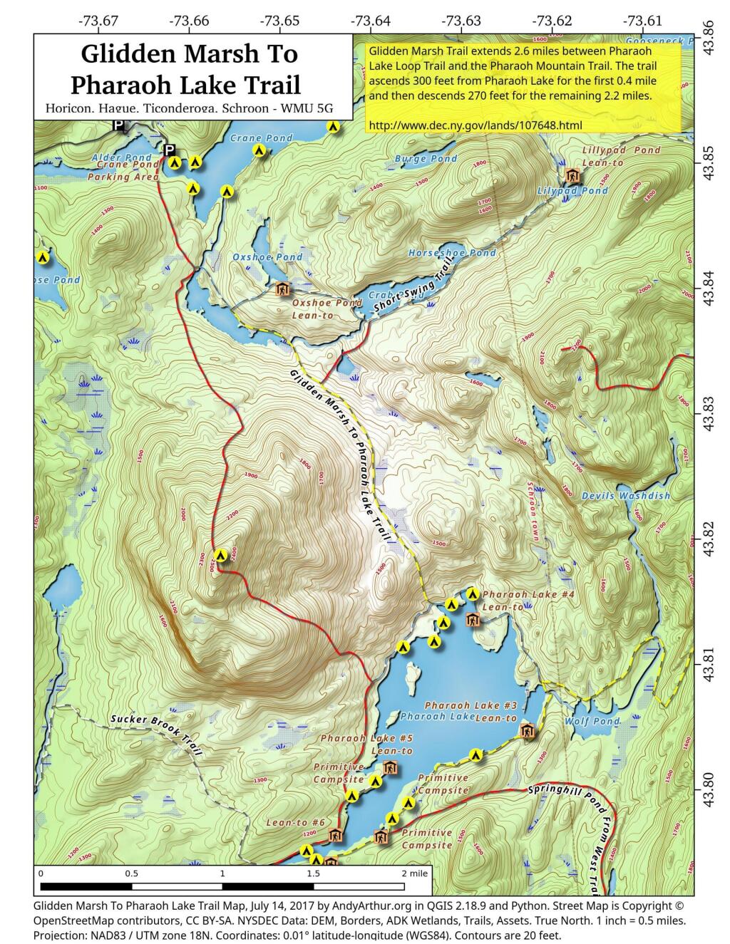
Map: Glidden Marsh To Pharaoh Lake Trail
Download a High Resolution JPEG Image of the Glidden Marsh To Pharaoh Lake Trail or an Adobe Acrobat Printable PDF of the Glidden Marsh To Pharaoh Lake Trail.
About Map: Glidden Marsh To Pharaoh Lake Trail ....
There are two ways to get between Crane Pond and Pharaoh Lake. One brings you over Pharoah Mountain, which has great views but it's a much bigger climb, especially on the southern side.
Pharaoh Mountain Trail (2,556 feet) extends 3.8 miles between the Pharaoh Lake Trail and Crane Pond Trail. The trails ascends 1,355 feet in 1.2 miles to the summit and then descends 1,405 feet in 2.6 miles to Crane Pond.
Glidden Marsh Trail extends 2.6 miles between Pharaoh Lake Loop Trail and the Pharaoh Mountain Trail. The trail ascends 300 feet from Pharaoh Lake for the first 0.4 mile and then descends 270 feet for the remaining 2.2 miles.

Bookmark my free Interactive GPS Map for your phone:
https://andyarthur.org/ny
... shows your location as a blue dot in relationship to campsites, trails, state land. This online map requires cell service, won't work in remote country, so also bring a paper map.
Free Download of New & Historical USGS 1:24k Topograpic Maps
Interactive maps with backcountry and roadside camping: New York, Pennsylvania, West Virginia & Vermont. List of NYS DEC Lean-Tos and Firetowers.
Google Spreadsheet with Roadside, Primitive and Pay Campsites
More about Pharaoh Lake Wilderness...
The Pharaoh Lake Wilderness Area, an Adirondack Park unit of New York's Forest Preserve, straddles the Essex County-Warren County line in the towns of Ticonderoga, Hague, Horicon and Schroon. The county road along the east shore of Schroon Lake forms the western boundary; to the north, private land and NY 74 form the boundary. The state land boundary forms most of the remaining perimeter except for a stretch of NY 8 on the south. The area contains 39 bodies of water covering 1,100 acres (4.4 km2), 62.8 miles (101 km) of foot trails, and 14 lean-tos. Download all maps as a PDF: https://www.scribd.com/document/640711783/Pharaoh-Lake-Wilderness-Map-Pack
Aerial Photos
Pharoah Lake
Photo: Adirondack Homeland Rock at Crane Pond Road
Maps and Interactives
Spring Hill Ponds
Pharoah Lake
Most of the Pharoah Lake Trail follows an old woods road
Grizzle Ocean
Gooseneck Pond
Crane Pond
Pharoah Lake And Vicinty
Treadway Mountain from Putnam Pond Campground
Pharaoh Lake Trail
Pharaoh Lake
Lost Pond Trail
Gull And Spectacle Pond
Goose Pond Trail
Goose Pond
Glidden Marsh To Pharaoh Lake Trail
Crane Pond Road
Berrymill Pond Trail From North
... photos, maps and other content from from Pharaoh Lake Wilderness.