Map: Coreys Road Campsites

Download a High Resolution JPEG Image of the Coreys Road Campsites or an Adobe Acrobat Printable PDF of the Coreys Road Campsites.

Bookmark my free Interactive GPS Map for your phone:
https://andyarthur.org/ny
... shows your location as a blue dot in relationship to campsites, trails, state land. This online map requires cell service, won't work in remote country, so also bring a paper map.
Free Download of New & Historical USGS 1:24k Topograpic Maps
Interactive maps with backcountry and roadside camping: New York, Pennsylvania, West Virginia & Vermont. List of NYS DEC Lean-Tos and Firetowers.
Google Spreadsheet with Roadside, Primitive and Pay Campsites
More about High Peaks Wilderness...
The High Peaks Wilderness Area, the largest Forest Preserve unit in the U.S. state of New York, is located in three counties and six towns in the Adirondack Park: Harrietstown in Franklin County, North Elba, Keene, North Hudson and Newcomb in Essex County and Long Lake in Hamilton County.
It is roughly bounded on the north by NY 3, the old Haybridge Road, which runs from Cold Brook to Averyville, the Adirondak Loj property at Heart Lake, the Mount Van Hoevenberg area and NY 73 near the Cascade Lakes. Private land to the west of Route 73 forms the eastern boundary. The southern boundary is formed by privately owned lands, including the Ausable Club, Finch, Pruyn, and Company, National Lead Company and the State University of New York College of Environmental Science and Forestry's Huntington Wildlife Forest. This wilderness is bounded on the west by Long Lake and the Raquette River.
There is one significant inholding: the Johns Brook Lodge, a cabin and surrounding campsites operated by the Adirondack Mountain Club, 3.5 miles (5.6 km) along the eponymous trail and brook from the popular "Garden" parking area and access point near Keene Valley.
The area includes 112 bodies of water on 1,392 acres (5.6 km2), 238.4 miles (383.5 km) of foot trails, 52.3 miles (84.1 km) of horse trails, and 84 lean-tos. The area contains 36 of the 46 Adirondack High Peaks, including the tallest, Mount Marcy.
The topography ranges from small areas of low-lying swampland (e.g., along the Raquette and Saranac Rivers) to the highest point in New York State at the top of Mount Marcy. Although there is a considerable variety of topography, it is predominantly high mountain country. Like the topography, the forest cover also varies from pole-size hardwoods to mature, large diameter hardwood and softwood stands to the spruce-fir of the subalpine region.
Maps and Interactives
Roaring Brook Falls
National Lead Mine in Tahawus
Moose Pond
Keene, New York
Hurricane Mountain
Giant Mountain
Dysfunction Junction (US 9 and NY 73) outside of Keene
Cascades Lake
Before Dysfunction Junction – NY 73 and US 9 (1942 Aerial)
Before Dysfunction Junction – NY 73 and US 9 (1955 Topo)
Bald Peak
Adirondac – Tahawus Club – Mac Intype Ironworks (1904)
Whiteface Mountain
Keene Valley
Adirondack High Peaks
High Peaks Region – USGS 1:24k Topographic Map Index
Henderson Lake
Elk Lake To Dix Mountain Trail
Dix Mountain Trail
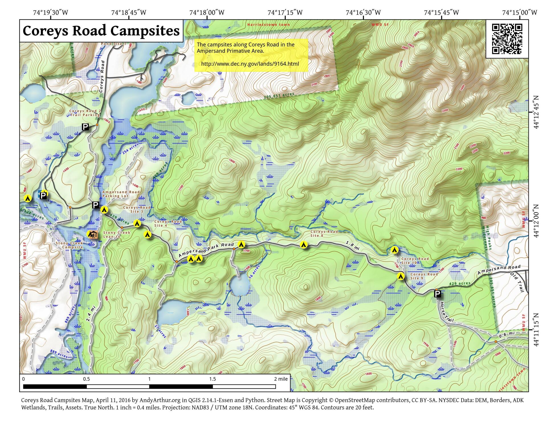
Coreys Road Campsites
Calamity Brook Trail
... photos, maps and other content from from High Peaks Wilderness.