Search Results for: map cedar lakes 2
USGS Topographic Maps – Dutchess to Livingston Counties
Counties: Albany to Delaware / Dutchess to Livingston / Madison to Otsego / Putnam to Suffolk / Sullivan to Yates
Browse Topographic Maps: Full State / Historical USGS Topographic Maps
Dutchess County


Erie County


Essex County


Franklin County


Fulton County


Genesee County


Greene County


Hamilton County


Herkimer County


Jefferson County


Kings County


Lewis County


Livingston County


Locations and Maps of Lean-Tos in NYS
Interactive Map of Lean-Tos
You can get a downloadable, more detailed map with campsites, lean-tos, scenic vistas and trails.
Note: This list is sorted from North to South, and West to East in New York, therefore the farthest North Lean-To in NY State is in the Debar Mountain Wild Forest, and the farthest south one is in David A. Sarnoff Pine Barrens Preserve in Long Island. Location links take you to aerial photos of the Lean-Tos on the free ACME Mapper.
Download or View this Chart on Google Sheets
| State Forest Land | Name | Type | Description | Location |
|---|---|---|---|---|
| Debar Mtn. Wild Forest | Debar Mountian Lean-To | Lean-To | 44.598926, -74.228592 | |
| Debar Mtn. Wild Forest | Grass Pond Lean-To | Lean-To | 44.493389, -74.251194 | |
| Taylor Pond Wild Forest | North Shore Taylor Pond Lean-To | Lean-To | Managed By Operations | 44.4897, -73.861427 |
| Taylor Pond Wild Forest | South East Taylor Pond Lean-To | Lean-To | Managed By Operations | 44.482888, -73.853777 |
| Taylor Pond Wild Forest | Northwest Shore Taylor Pond Lean-To | Lean-To | Managed By Operations | 44.477689, -73.881283 |
| Taylor Pond Wild Forest | Poke-O-Moonshine Summit Lean-To | Lean-To | 44.399797, -73.514557 | |
| Saint Regis Canoe Area | Fish Pond Campsite 2 | Lean-To | 44.396133, -74.370421 | |
| Saint Regis Canoe Area | Fish Pond Campsite 5 | Lean-To | 44.391301, -74.365807 | |
| Saint Regis Canoe Area | St. Regis Pond South Shore Lean-To | Lean-To | Within The Adopt A Lean-To System | 44.380642, -74.320299 |
| Saint Regis Canoe Area | St. Regis Pond Campsite 19 | Lean-To | 44.380626, -74.320423 | |
| Wolf Lake State Forest | Beaver Flow Lean-To | Lean-To | 44.357822, -75.316001 | |
| Mckenzie Mtn. Wilderness | Loch Bonnie Lean-To | Lean-To | 44.347347, -73.995669 | |
| Mckenzie Mtn. Wilderness | White Face Brook Lean-To | Lean-To | 44.344217, -73.928647 | |
| Wolf Lake State Forest | Wolf Lake Lean-To | Lean-To | 44.336323, -75.313886 | |
| Saranac Lakes Wild Forest | Lake Placid Campsite 3 | Lean-To | 44.332595, -73.95668 | |
| Saranac Lakes Wild Forest | Lake Placid Campsite 2 | Lean-To | 44.332296, -73.956626 | |
| Wolf Lake State Forest | Moon Pond Lean-To | Lean-To | 44.332276, -75.321172 | |
| Saranac Lakes Wild Forest | Follensby Clear | Lean-To | 44.325095, -74.349897 | |
| Wolf Lake State Forest | Huckleberry Lake Lean-To | Lean-To | 44.324272, -75.333738 | |
| Mckenzie Mtn. Wilderness | Placid Lean-To | Lean-To | 44.321456, -74.030786 | |
| Saranac Lakes Wild Forest | Lean-To | 44.309124, -74.18053 | ||
| Saranac Lakes Wild Forest | Lean-To | 44.302887, -74.302634 | ||
| Saranac Lakes Wild Forest | Lean-To | 44.289835, -74.216869 | ||
| Saranac Lakes Wild Forest | Lean-To | 44.286942, -74.289775 | ||
| Saranac Lakes Wild Forest | Lean-To | 44.286657, -74.162602 | ||
| Saranac Lakes Wild Forest | Lean-To | 44.271712, -74.273283 | ||
| Saranac Lakes Wild Forest | Lean-To | 44.265599, -74.24293 | ||
| Hurricane Mountain Primitive Area | Lost Pond/Biesemeyer | Lean-To | 44.26073, -73.710011 | |
| Hurricane Mountain Primitive Area | Gulf Brook Lean-To | Lean-To | 44.253097, -73.71796 | |
| Saranac Lakes Wild Forest | Lean-To | 44.228772, -74.375533 | ||
| High Peaks Wilderness | Lean-To | 44.198805, -74.31831 | ||
| Horseshoe Lake Wild Forest | Eagle Landing Lean-To | Lean-To | 44.19683, -74.512309 | |
| High Peaks Wilderness | Lean-To | 44.177317, -74.321808 | ||
| Giant Mountain Wilderness | Giant Mtn. Lean-To | Lean-To | 44.175641, -73.722171 | |
| Giant Mountain Wilderness | Giant Mtn. Lean-To | Lean-To | 44.175641, -73.722171 | |
| Horseshoe Lake Wild Forest | Lean-To | 44.158907, -74.560725 | ||
| High Peaks Wilderness | Lean-To | 44.15683, -74.313308 | ||
| Cranberry Lake Wild Forest | Lean-To | 44.1534, -74.884029 | ||
| High Peaks Wilderness | Lean-To | 44.147236, -74.318105 | ||
| Dix Mountain Wilderness | Bouquet Lean-To | Lean-To | 44.110904, -73.774043 | |
| High Peaks Wilderness | Lean-To | 44.105829, -74.312037 | ||
| Sargent Ponds Wild Forest | Lean-To | 44.102744, -74.321863 | ||
| Sargent Ponds Wild Forest | Lean-To | 44.082504, -74.333915 | ||
| Sargent Ponds Wild Forest | Lean-To | 44.081407, -74.335829 | ||
| High Peaks Wilderness | Lean-To | 44.065927, -74.326697 | ||
| Dix Mountain Wilderness | Lilian Brook Lean-To | Lean-To | 44.058989, -73.806533 | |
| Dix Mountain Wilderness | Slide Brook Lean-To | Lean-To | 44.044126, -73.805858 | |
| High Peaks Wilderness | Lean-To | 44.042977, -74.349335 | ||
| High Peaks Wilderness | Lean-To | 44.041409, -74.350149 | ||
| High Peaks Wilderness | Lean-To | 44.02862, -74.366763 | ||
| High Peaks Wilderness | Lean-To | 44.002655, -74.38648 | ||
| William C. Whitney Wilderness | Lake Lila # 7 | Lean-To | 44.002145, -74.775682 | |
| High Peaks Wilderness | Lean-To | 43.998164, -74.392741 | ||
| Independence River Wild Forest | Trout Pond Lean To | Lean-To | 43.928489, -74.94487 | |
| Independence River Wild Forest | Trout Pond Lean To | Lean-To | 43.928489, -74.94487 | |
| Sargent Ponds Wild Forest | Deerland Carry Lean-To 2 | Lean-To | Fair Condition | 43.926218, -74.475396 |
| Sargent Ponds Wild Forest | Deerland Carry Lean-To 1 | Lean-To | Fair Condition | 43.925781, -74.475846 |
| Sargent Ponds Wild Forest | Pinebrook Lean-To | Lean-To | Fair Condition | 43.906646, -74.50259 |
| Sargent Ponds Wild Forest | Lean-To | 43.902847, -74.548063 | ||
| Blue Mountain Wild Forest | North End Tirrel Pond Lean-To | Lean-To | 43.887378, -74.377739 | |
| Sargent Ponds Wild Forest | Lean-To | 43.879414, -74.606052 | ||
| Blue Mountain Wild Forest | O’neil Lean-To | Lean-To | 43.875096, -74.367316 | |
| Sargent Ponds Wild Forest | Lean-To | 43.871006, -74.628108 | ||
| Sargent Ponds Wild Forest | Lean-To | 43.870772, -74.628507 | ||
| Sargent Ponds Wild Forest | Lean-To | 43.87072, -74.629172 | ||
| Sargent Ponds Wild Forest | Lower Sargents Pond Lean-To | Lean-To | Fair Condition | 43.859331, -74.562695 |
| Blue Ridge Wilderness | Boulder | Lean-To | 43.841564, -74.472689 | |
| Sargent Ponds Wild Forest | Lean-To | 43.836898, -74.535266 | ||
| Moose River Plains Wild Forest | Lean-To | 43.831671, -74.661756 | ||
| Moose River Plains Wild Forest | Lean-To | 43.831605, -74.661511 | ||
| Moose River Plains Wild Forest | Lean-To | 43.831434, -74.660902 | ||
| Blue Ridge Wilderness | Cascade Pond Lean-To | Lean-To | 43.829744, -74.436618 | |
| Independence River Wild Forest | Panther Pond Lean-To | Lean-To | 43.823535, -75.169312 | |
| Blue Ridge Wilderness | Wilson Pond | Lean-To | 43.820192, -74.46868 | |
| Blue Ridge Wilderness | Stephens Pond | Lean-To | 43.818674, -74.420524 | |
| Blue Ridge Wilderness | Stephens Pond | Lean-To | 43.818674, -74.420524 | |
| Blue Ridge Wilderness | Stephens Pond | Lean-To | 43.818674, -74.420524 | |
| Blue Ridge Wilderness | Stephens Pond | Lean-To | 43.818674, -74.420524 | |
| Blue Ridge Wilderness | Stephens Pond | Lean-To | 43.818674, -74.420524 | |
| Blue Ridge Wilderness | Stephens Pond | Lean-To | 43.818674, -74.420525 | |
| Sargent Ponds Wild Forest | Lean-To | 43.817134, -74.64378 | ||
| Sargent Ponds Wild Forest | Lean-To | 43.81709, -74.643251 | ||
| Sargent Ponds Wild Forest | Lean-To | 43.8162, -74.644668 | ||
| Blue Ridge Wilderness | Blue Ridge Lean-To | Lean-To | 43.80014, -74.610139 | |
| Moose River Plains Wild Forest | 8thlake East Shore Lean-To | Lean-To | 43.789783, -74.698592 | |
| Moose River Plains Wild Forest | 8th Lake North Shore Lean-To | Lean-To | 43.780115, -74.704439 | |
| Moose River Plains Wild Forest | 8th Lake Island Lean-To | Lean-To | 43.779025, -74.704429 | |
| Moose River Plains Wild Forest | Lean-To | 43.75639, -74.717817 | ||
| Moose River Plains Wild Forest | Lean-To | 43.750767, -74.734643 | ||
| Moose River Plains Wild Forest | Lean-To | 43.747805, -74.744199 | ||
| Independence River Wild Forest | Pine Lake Lean-To | Lean-To | 43.708394, -75.146453 | |
| Haderondah | Middle Branch Lake | Lean-To | 43.702926, -75.096002 | |
| Siamese Ponds Wilderness | Hour Pond Lean-To | Lean-To | 43.70112, -74.158221 | |
| Haderondah | Cedar Pond Lean To | Lean-To | 43.69597, -75.082602 | |
| Haderondah | Middle Settlement Lake | Lean-To | 43.685949, -75.098614 | |
| West Canada Lakes Wilderness | Colvin Brook Lean-To | Lean-To | 43.652414, -74.49038 | |
| Lake George Wild Forest | Five Mile Mountain Lean-To | Lean-To | Lean-To W/ Privy And Firering | 43.647336, -73.574534 |
| Black River Wild Forest | Remsen Falls Lean-To | Lean-To | 43.629925, -75.036288 | |
| Lake George Wild Forest | Fifth Peak Lean-To | Lean-To | Lean-To W/ Privy And Firering | 43.619313, -73.584112 |
| Black River Wild Forest | Woodhull Lake Lean-To | Lean-To | 43.599885, -75.020382 | |
| Lake George Wild Forest | Black Mountain Ponds Lean-To | Lean-To | Lean-To With Privy And Firering | 43.59966, -73.533064 |
| West Canada Lakes Wilderness | Pillsbury Lake Lean-To | Lean-To | 43.596898, -74.531665 | |
| Lake George Wild Forest | Lean-To | Campsite With Lean-To 13-27 | 43.595821, -73.517951 | |
| Lake George Wild Forest | Lean-To | Campsite With Lean-To 5-10 | 43.587168, -73.527759 | |
| Lake George Wild Forest | Greenland Pond Leanto | Lean-To | Leanto With Privy, Picnic Table And Fire Ring | 43.577804, -73.51684 |
| Lake George Wild Forest | Fishbrook Pond North Leanto | Lean-To | Leanto With Privy, Picnic Table And Fire Ring | 43.576039, -73.536103 |
| Lake George Wild Forest | Fishbrook Pond South Leanto | Lean-To | Leanto With Privy, Picnic Table And Fire Ring | 43.573872, -73.538477 |
| Black River Wild Forest | Sand Lake Falls Lean-To | Lean-To | 43.558914, -75.003058 | |
| Black River Wild Forest | Gull Lake Lean-To | Lean-To | 43.553747, -75.059378 | |
| Black River Wild Forest | Chub Pond Lean-To #2 | Lean-To | 43.529823, -75.042494 | |
| Black River Wild Forest | Chub Pond Lean-To #1 | Lean-To | 43.524598, -75.043801 | |
| West Canada Lakes Wilderness | T Lake Leant-To | Lean-To | 43.452718, -74.582282 | |
| Silver Lake Wilderness | Hamilton Lake Stream Lean-To 1 | Lean-To | 43.39716, -74.455046 | |
| Silver Lake Wilderness | Hamilton Lake Stream Lean-To 2 | Lean-To | 43.397156, -74.455065 | |
| Cobb Brook State Forest | Leanto | Lean-To | 43.344545, -75.67222 | |
| Silver Lake Wilderness | Mud Lake Lean-To | Lean-To | 43.342671, -74.456291 | |
| Deruyter State Forest | Deruyter Lean-To | Lean-To | 42.820185, -75.859105 | |
| Morgan Hill State Forest | Morgan Hill Lean-To | Lean-To | 42.767202, -76.011256 | |
| Perkins Pond State Forest | Flt Lean-To | Lean-To | 42.642307, -75.743766 | |
| Dutch Settlement State Forest | Lean-To | Lean-To | 42.629438, -74.267543 | |
| Whaupaunaucau State | Leanto | Lean-To | 42.606063, -75.467114 | |
| Burnt-Rossman Hills State Forest | Eminence Lean-To | Lean-To | 42.543304, -74.488595 | |
| Clapper Hollow State Forest | Clapper Hollow Lean-To | Lean-To | 42.528201, -74.642004 | |
| Tuller Hill State Forest | Tuller Hill Lean-T0 | Lean-To | Rebuilt In 2002 From Local State Forest Red Pine, Built By Volunteers From Suny Cortland | 42.512201, -76.120824 |
| Kennedy State Forest | Foxfire Leanto | Lean-To | 42.472853, -76.178732 | |
| Ludlow Creek State Forest | Ludlow Creek Lean-To | Lean-To | 8′ X 10′ | 42.445802, -75.701507 |
| Genegantslet State Forest | Top Ten Lean-To | Lean-To | 20′ X 20′ | 42.422887, -75.767435 |
| Robinson Hollow State Forest | Kimme Lean-To | Lean-To | 42.390596, -76.271801 | |
| Sugar Hill State Forest | Vanzandt Lean-To | Lean-To | 42.389935, -76.972601 | |
| Sugar Hill State Forest | The Twin Lean-To’s | Lean-To | Two Lean-To At This Location | 42.382253, -77.00268 |
| Sugar Hill State Forest | Templar Rd Lean-To | Lean-To | 42.373082, -76.95548 | |
| Sugar Hill State Forest | Parks Hollow Lean-To | Lean-To | 42.369463, -77.012608 | |
| Huntersfield State Forest | Lean-To | Lean-To | 42.355041, -74.346067 | |
| Beebe Hill State Forest | Beebe Hill Lean-To | Lean-To | 42.335425, -73.484181 | |
| Shindagin Hollow State Forest | Shindagin Lean-T0 | Lean-To | Scheduled For Replacement In 2004 | 42.327644, -76.329036 |
| Danby State Forest | Bald Hill Lean-To | Lean-To | 42.327042, -76.490061 | |
| Danby State Forest | Travor Rd Lean-To | Lean-To | 42.317642, -76.422544 | |
| Harvey Mountain State Forest | Harvey Mountain Lean-To | Lean-To | 42.313988, -73.441495 | |
| Burt Hill State Forest | On Finger Lake Trail Lean-To | Lean-To | 42.313213, -77.566373 | |
| Elm Ridge Wild Forest | On Elm Ridge Trail Lean-To | Lean-To | 42.306134, -74.173598 | |
| South Bradford State Forest | Moss Hill Lean-To | Lean-To | 42.289116, -77.118881 | |
| Windham Blackhead Range Wilderness | Batavia Kill Lean-To | Lean-To | 42.278839, -74.102579 | |
| Rusk Mountain Wild Forest | John Robb Leanto Lean-To | Lean-To | 42.189374, -74.238696 | |
| Rusk Mountain Wild Forest | Diamond Notch Lean-To | Lean-To | 42.16917, -74.256848 | |
| Hunter-West Kill Mountain Wilderness | Devil’s Acre Lean-To | Lean-To | Good Condition | 42.165955, -74.229624 |
| Arctic China State Forest | A-40 Lean-To | Lean-To | 42.158491, -75.362027 | |
| Barbour Brook State Forest | A-41 Lean To | Lean-To | 42.152807, -75.31021 | |
| Lean-To | 42.135655, -74.16269 | |||
| Dry Brook Ridge Wild Forest | German Hollow Road Lean-To | Lean-To | 42.134527, -74.616198 | |
| Lean-To | 42.119518, -74.086575 | |||
| Lean-To | 42.117719, -74.503199 | |||
| Lean-To | 42.115031, -74.49075 | |||
| Lean-To | 42.102787, -74.394826 | |||
| Lean-To | 42.098467, -74.09079 | |||
| Big Indian Wildernes Area | Rider Hollow Lean-To | Lean-To | 42.092012, -74.505713 | |
| Lean-To | 42.082185, -74.586611 | |||
| Big Indian Wildernes Area | Mckinly Hollow Lean-To | Lean-To | 42.075339, -74.485857 | |
| Lean-To | 42.071935, -74.28035 | |||
| Lean-To | 42.069751, -74.287449 | |||
| Lean-To | 42.067368, -74.586988 | |||
| Lean-To | 42.066913, -74.654635 | |||
| Big Indian Wildernes Area | Shandaken Brook Lean-To | Lean-To | 42.050274, -74.5106 | |
| Delaware Wild Forest | Campbell Mountain Trail Lean-To | Lean-To | 42.048989, -74.927363 | |
| Lean-To | 42.048641, -74.645056 | |||
| Lean-To | 42.039437, -74.594017 | |||
| Lean-To | 42.027316, -74.335645 | |||
| Delaware Wild Forest | Trout Pond Trail North Lean-To | Lean-To | Built For Ada | 42.012942, -74.946392 |
| Delaware Wild Forest | Trout Pond Trail South Lean-To | Lean-To | Built For Ada | 42.011758, -74.947566 |
| Big Indian Wildernes Area | Biscuit Brook Lean-To | Lean-To | 42.009105, -74.483852 | |
| Delaware Wild Forest | Pelnor Hollow Trail Lean-To | Lean-To | 42.005744, -74.867403 | |
| Big Indian Wildernes Area | Fall Brook Lean-To | Lean-To | 41.998075, -74.560392 | |
| Lean-To | 41.959182, -74.406877 | |||
| Lean-To | 41.94006, -74.632055 | |||
| David A. Sarnoff Pine Barrens Preserve | Interior Lean- To | Lean-To | 40.89774, -72.660615 |

Cedar Lakes
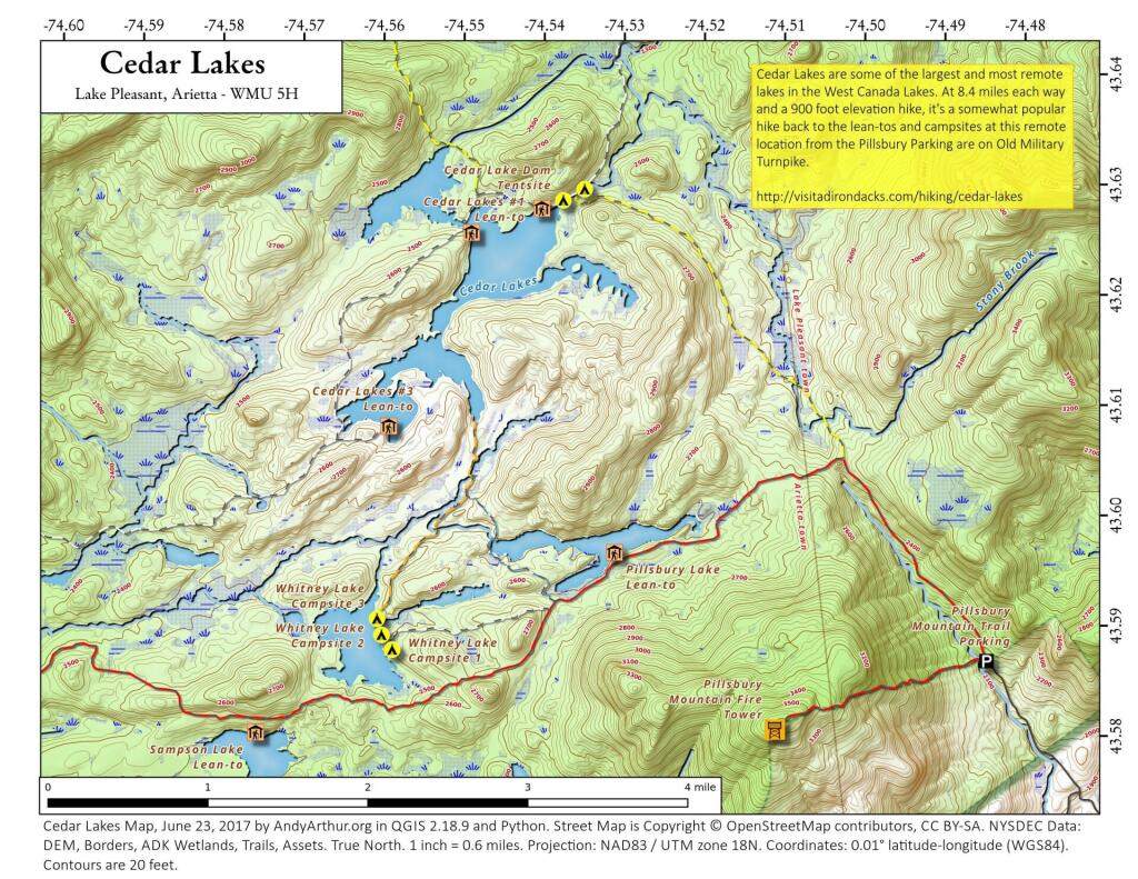
As late as the 1954 you could drive up to Pillsbury Lake
The lake was privately owned at the time with the main parking for Cedar Lakes in the forest preserve at the top of the hill.
Essex Chain of Lakes – Coordinates and Maps 🏕
Essex Chain of Lakes – Coordinates and Maps 🏕
Interactive Map
Download the KML file for use in Google Maps or GPS apps.
Printable Maps
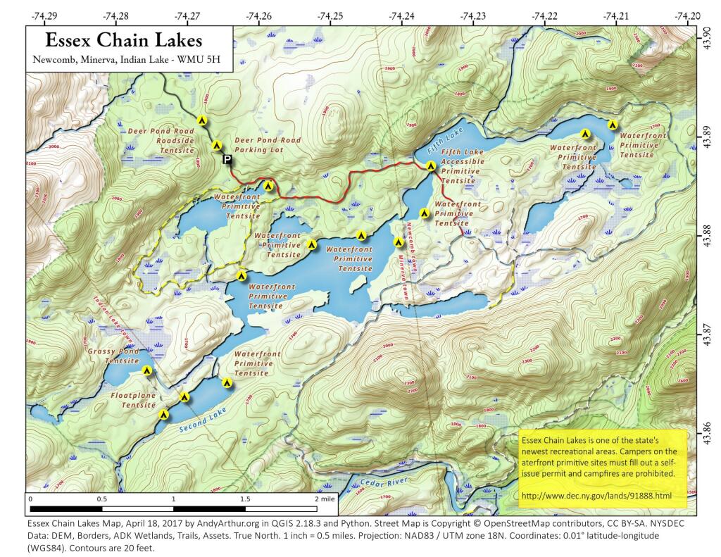
List of Essex Chain of Lakes Campsites
Here is a list of Essex Chain Lake Campsites. Special restrictions and reservation exist for many of these campsites, see the DEC website for details.
You can also get this as a Google Sheet for ease of downloading into your GPS.
| Name | Descrip | Latitude | Longitude |
| Camp Six Rd Seasonal (Fall) Parking Area | 2-3 spaces | 43.8781945875647 | -74.1951257407619 |
| Camp Six Road Roadside Tentsite | 43.891098208087 | -74.1858223467572 | |
| Camp Six Road Roadside Tentsite | 43.880775618509 | -74.1920319664505 | |
| Camp Six Road Roadside Tentsite | 43.8867689717605 | -74.1881150206844 | |
| Cedar/Hudson River Campsite | 43.8526463367848 | -74.188226184425 | |
| Chain Lakes Rd South Seasonal (Fall) Parking Area | 43.8398670879606 | -74.2193187297406 | |
| Chain Lakes Road South Parking Lot | 43.8169730010758 | -74.206490005958 | |
| Chain Lakes Road South Roadside Tentsite | 43.8354885828321 | -74.2095424278515 | |
| Chain Lakes Road South Roadside Tentsite | 43.8318737372315 | -74.2087246610165 | |
| Chain Lakes Road South Roadside Tentsite | 43.8284300483248 | -74.2005840726962 | |
| Cornell Road Roadside Tentsite | 43.9127605502315 | -74.2589305446633 | |
| Cornell Road Roadside Tentsite | 43.90792941637 | -74.2708080639985 | |
| Cornell Road Roadside Tentsite | 43.9067653589248 | -74.2728139422411 | |
| Cornell Road Roadside Tentsite | 43.9119638675587 | -74.2629609782825 | |
| Deer Pond Road Parking Lot | 43.8881877909056 | -74.26459017266 | |
| Deer Pond Road Roadside Tentsite | 43.8921619513765 | -74.2680906874901 | |
| Deer Pond Road Roadside Tentsite | 43.8896153020103 | -74.2660494488172 | |
| Essex Chain Equestrian Staging Area | Includes accessible mounting platform & kiosk | 43.9080902992726 | -74.1856206534589 |
| Floatplane Tentsite | 43.8624107973145 | -74.2738175850679 | |
| Floatplane Tentsite | 43.8441807728989 | -74.2572948564662 | |
| Floatplane Tentsite | 43.8641746165881 | -74.2708879596156 | |
| Grassy Pond Tentsite | 43.8668988556171 | -74.2761009397051 | |
| Indian River Put-In Parking Lot | 43.8016889699131 | -74.2299529872379 | |
| Indian River Put-In Water Access | Hand-carry launch | 43.8017043411256 | -74.228261437504 |
| Outer Gooley Parking Area | 43.8273906506622 | -74.2007441162829 | |
| Parking Area | 43.9144824495811 | -74.1846526844935 | |
| Pine Lake Primtive Tentsite | 43.8493835353493 | -74.2458702713384 | |
| Polaris (Iron) Bridge Tentsite | 43.8946526943318 | -74.1651586934731 | |
| Polaris Bridge Parking Area | 2-3 spaces | 43.8954955101626 | -74.1682746441243 |
| Waterfront Primitive Tentsite | 43.8803564638727 | -74.245948680651 | |
| Waterfront Primitive Tentsite | 43.8794781290843 | -74.2529060663751 | |
| Waterfront Primitive Tentsite | 43.8825615413222 | -74.2370898191954 | |
| Waterfront Primitive Tentsite | 43.8854551161564 | -74.2589146456769 | |
| Waterfront Primitive Tentsite | 43.8763773474625 | -74.2627649431543 | |
| Waterfront Primitive Tentsite | 43.8913218971427 | -74.2106406874051 | |
| Waterfront Primitive Tentsite | 43.865579967021 | -74.2649096009151 | |
| Waterfront Primitive Tentsite | 43.8796521294405 | -74.2407518111291 | |
| Waterfront Primitive Tentsite | 43.8904359124813 | -74.2144855367511 |
Map and Coordinates List for NYS DEC Firetowers 🗼
Discover a wealth of information on this page about fire towers situated on state lands, accessible through invigorating hikes that lead to panoramic vistas. Interactive maps guide your exploration, offering insights into the locations and trails leading to these towering viewpoints. Additionally, find convenient links to other pages that delve deeper into fire towers across the entirety of New York State. Embark on a journey that combines outdoor adventure with breathtaking scenery, as you navigate the trails and pathways leading to these historic landmarks that have stood as guardians of the landscape. This resource opens doors to captivating experiences that allow you to savor the beauty of nature from elevated perspectives while providing avenues for further exploration of New York’s fire tower heritage.
Here is a list of Fire Towers on NYS DEC lands. You can get this also on Google Sheets. Does not include the Dickinson Hill Fire Tower in Grafton, which is part of the Grafton Lakes State Park. You might also be interested in nearby camping opportunities.
| Tower | State Land | Notes | Coordinates |
| Azure Mtn. Fire Tower | Debar Mountain Wild Forest | Relatively short hike. | 44.5412601955876, -74.5007131438668 |
| Balsam Lake Mountain | Balsam Lake Mountain Wild Forest | Longer hike along old road. | 42.0453530369935, -74.5943882522534 |
| Belfry Mountain Fire Tower | Hammond Pond Wild Forest | Very short hike up dirt road. | 44.0977783227959, -73.5480575565177 |
| Berry Hill Firetower | Mcdonough State Forest | Only up to second level is open, no upper level access. | 42.5498033738312, -75.6903147862666 |
| Black Mountain Fire Tower | Lake George Wild Forest | Longer hike up a snowmobile trail. | 43.6068253423597, -73.5315598873687 |
| Blue Mountain Fire Tower | Blue Mountain Wild Forest | Very popular, worn-down trail. | 43.8722986188442, -74.4007350580445 |
| Lowville Demostration Area Fire Tower | Lowville Demonstration Area | No access to tower, part of demonstration forest. | 43.8093267984132, -75.4730800808841 |
| Goodnow Mountain Fire Tower | Suny Esf Lands | Open to public, SUNY ESF Lands | 43.9598725064095, -74.2096091339017 |
| Hadley Mountain Fire Tower | Wilcox Lake Wild Forest | Popular hike in Southern Adirondacks. | 43.3769100935034, -73.9709647959219 |
| Hunter Mountain Fire Tower | Hunter-West Kill Wilderness | Multiple approaches to this fire tower offer different hikes with different amounts of work. | 42.1779299997605, -74.2297619994181 |
| Hurricane Mountain Firetower | Hurricane Mountain Primitive Area | The only fire tower remaining in the Adirondack High Peaks. | 44.2352949729449, -73.7101070215222 |
| Kane Mountain | Shaker Mountain Wild Forest | Short hike near Caroga Lake. | 43.1810788942093, -74.5151618559196 |
| Beebe Hill Fire Tower | Beebe Hill State Forest | Shorter hike near Austerlitz and Massachussetts border. | 42.3361525194561, -73.4862760091067 |
| Leonard Hill Fire Tower | Leonard Hill State Forest | You can drive to this tower. Bottom floors removed, no access to tower. | 42.4510039574136, -74.3529141572996 |
| Lyon Mountain Fire Tower | Chazy Highlands Wild Forest | Longer hike, new trail avoids severely erroded old trail | 44.7048354583899, -73.8627762019644 |
| Mount Adam Fire Tower | High Peaks Wilderness | Just south of main high peaks area. | 44.0874829962416, -74.0228637207712 |
| Mount Nimham Fire Tower | Nimham Mountain Mua | Near Beacon | 41.4611546516545, -73.72510657899 |
| Mount Tremper | Phoenicia – Mt. Tobias Wild Forest | Follow an old woods road to summit. | 42.0739476727477, -74.2781528438603 |
| Mt Arab Fire Tower | Horseshoe Lake Wild Forest | Relatively short hike outside of Tupper Lake. | 44.2046152316571, -74.5879293129745 |
| Overlook Mountain | Overlook Mountain Wild Forest | Popular hike outside of Woodstock, follows a gated road. | 42.085023587202, -74.0933592964641 |
| Owls Head Firetower | Sargent Ponds Wild Forest | Moderate hike outside of Long Lake. | 43.9542904615568, -74.4984616500416 |
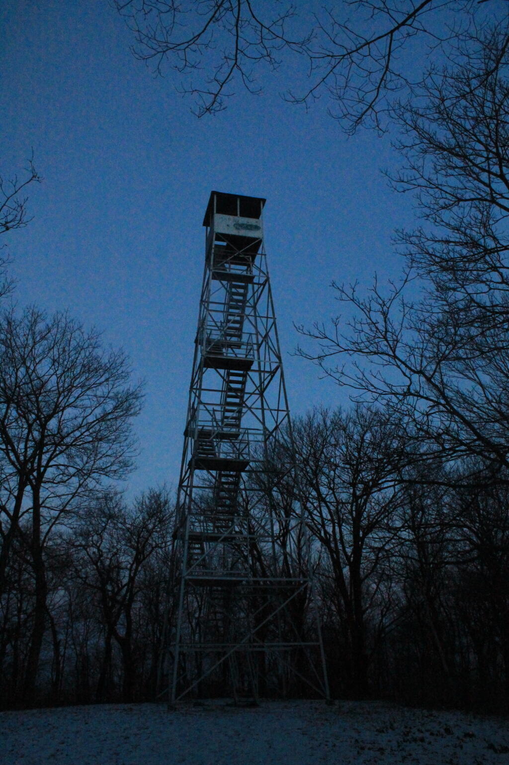
| Pillsbury Mountain Fire Tower | Jessup River Wild Forest | Mile long hike to a firetower with views over Perkins Clearing and areas around Spectulator | 43.5807556043109, -74.5118079500206 |
| Poke-O-Moonshine Fire Tower | Taylor Pond Wild Forest | New trail is less steep and follows old woods road. | 44.4019104158425, -73.5130620065356 |
| Red Hill Fire Tower | Sundown Wild Forest | 1 mile hike to a fairly remote firetower. | 41.9238122519417, -74.5170620256067 |
| Rondaxe Fire Tower | Fulton Chain Wild Forest | Quick hike outside of Old Forge that is very popular. | 43.7385880495938, -74.9129188420394 |
| Roosa Gap Firetower | Roosa Gap State Forest | Firetower on the Long Path in the Shawgunks. | 41.6176280752519, -74.4267422878805 |
| Snowy Mt | Jessup River Wild Forest | Popular hike, one of the more difficult towers to access. | 43.7003213769888, -74.3866001142199 |
| Spruce Mountain Fire Tower | Wilcox Lake Wild Forest | Trail crosses private land, closed during hunting season. | 43.2163188109202, -73.9061192265182 |
| St. Regis Mtn. Fire Tower | Saint Regis Canoe Area | Currently closed to public use. | 44.4085838385311, -74.3296128971506 |
| Stillwater Mountain Fire Tower | Independence River Wild Forest | Near the Stillwater Reservior. | 43.8618343053993, -75.033327606033 |
| Sugar Hill Fire Tower | Sugar Hill State Forest | Observation tower in Finger Lakes, during summer months you can drive to it, part of Six Nations Horse Cap. | 42.3871467022238, -77.0025364212371 |
| Vanderwhacker Mountain Fire Tower | Vanderwhacker Mountain Wild Forest | Rough seasonal road then 2 ½ mile hike. | 43.8982271055416, -74.0959123515681 |
| Wakely Mountain Fire Tower | Wakely Mountain Primitive Area | Near Cedar River Flow at Moose River Plains. Seasonal use road to access. | 43.7358887903725, -74.515229327937 |
| Woodhull Mountain Fire Tower | Black River Wild Forest | One of the longer hikes, part of the trail is an old railroad grade until you climb the peak. | 43.6230161401271, -74.9615452951445 |