Map: Canacadea State Forest
Download a High Resolution JPEG Image of the Canacadea State Forest or an Adobe Acrobat Printable PDF of the Canacadea State Forest.

Bookmark my free Interactive GPS Map for your phone:
https://andyarthur.org/ny
... shows your location as a blue dot in relationship to campsites, trails, state land. This online map requires cell service, won't work in remote country, so also bring a paper map.
Free Download of New & Historical USGS 1:24k Topograpic Maps
Interactive maps with backcountry and roadside camping: New York, Pennsylvania, West Virginia & Vermont. List of NYS DEC Lean-Tos and Firetowers.
Google Spreadsheet with Roadside, Primitive and Pay Campsites
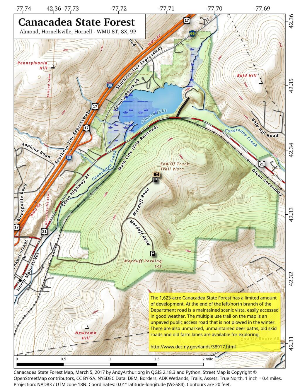
More about Almond Lake / Canacadea State Forest...
Operated as a flood control project by the US Army Corps of Engineers, Baltimore District. The dam was completed in June 1949 at a cost of $5.5 million and helps reduce flooding in Hornell.
http://corpslakes.usace.army.mil/visitors/projects.cfm?Id=E100240
Canacadea State Forest is located one mile west of Hornell, near the hamlet of Almond, in the Allegheny Plateau. The forest is located in the town of Hornellsville, Steuben County.
Tips for Using State Forests
Recreational opportunities in this state forest focus on rustic experiences with a limited amount of development. There are no formally designated trails. Town, county, and DEC roads provide mountain biking opportunities.
Hunting and trapping are permitted on the property in accordance with all game regulations, unless otherwise posted. Traps may not be set on public road right of ways. Body gripping traps set on land must be at least 100 feet from public trails. Permanent tree stands are prohibited. However, a tree stand or blind is allowed, provided that it does not injure any trees, is properly marked or tagged with the owner's name and address or valid hunting or fishing license number, and is placed and used during big game season, migratory game bird season, or turkey season, but no more than thirty days in one location per calendar year.
http://www.dec.ny.gov/lands/38917.html
... photos, maps and other content from from Allegany County.