Map: Auger Falls Via Griffin (East Side)

Download a High Resolution JPEG Image of the Auger Falls Via Griffin (East Side) or an Adobe Acrobat Printable PDF of the Auger Falls Via Griffin (East Side).
About Map: Auger Falls Via Griffin (East Side) ....
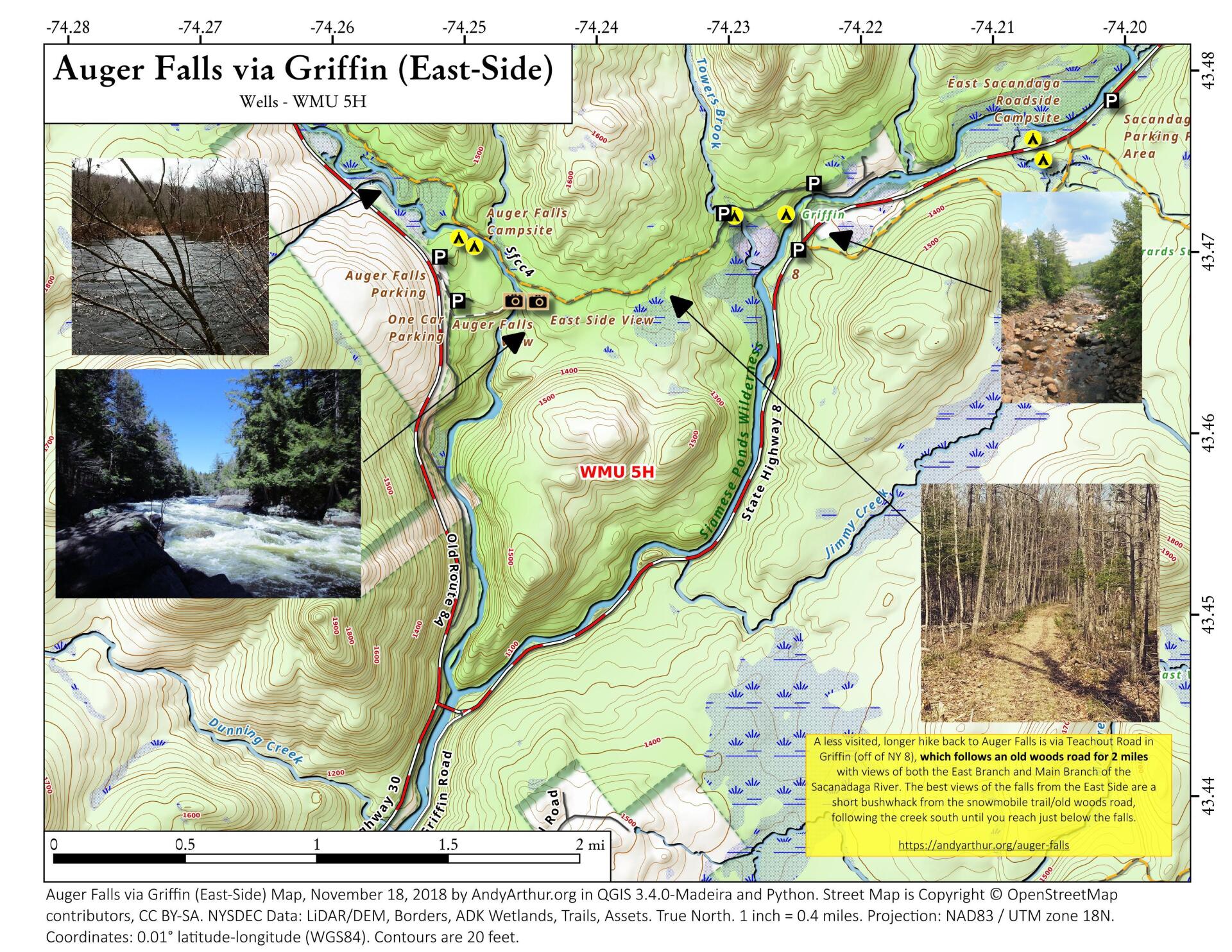
A little used way of hiking back to Auger Falls via NY 8 and Griffin and the Auger Falls Snowmobile Trail. You can either park on NY 8 or at the Griffin Parking lot, then hike back from there. It's about two miles, hiking along an old woods road. The best views of the falls are short bushwhack from the the trail when it runs along the river, heading south along the river, until you are looking directly over the falls.

Bookmark my free Interactive GPS Map for your phone:
https://andyarthur.org/ny
... shows your location as a blue dot in relationship to campsites, trails, state land. This online map requires cell service, won't work in remote country, so also bring a paper map.
Free Download of New & Historical USGS 1:24k Topograpic Maps
Interactive maps with backcountry and roadside camping: New York, Pennsylvania, West Virginia & Vermont. List of NYS DEC Lean-Tos and Firetowers.
Google Spreadsheet with Roadside, Primitive and Pay Campsites
More about Auger Falls...
This 40 foot falls is at the beginning of a series of drops, plunges and cascades totaling over 100 feet though this narrow gorge lined with Hemlocks on the Sacandaga River. Many potholes can be seen along the edge of the gorge when the water level is low.
5.0 miles N. of Wells. From Wells, drive N on Rte 30 to the junction of Rte 30 & Rte 8. Continue another 1.7 miles on Rte 30 & turn right into a dirt parking area. Park and walk back towards Rte 30, and follow the old dirt road to the left, which parallels Rte 30. At the end of the road, look for the DEC register, marking the beginning of the trail. Follow the colored DEC trail markers for 0.3 mile to the top of the falls. You'll hear the roar of the falls shortly after you start the hike.
http://www.adirondackexperience.com/recreation/hiking/auger-falls
Maps and Interactives
Old Route 8A
Auger Falls – Fork Mountain Trail
Auger Falls Via Griffin (East Side)
... photos, maps and other content from from Auger Falls.