NY State Camping Maps

Maps of primitive or backcountry campsites and lean-tos in New York State.

Free Primitive and Roadside Campsites in Central New York

Free Primitive and Roadside Campsites in Central New York

An overview of free primitive and roadside campsites located throughout the Central New York region of New York State including Broome County, Cortland County, Chenango County, Madison County, Otsego County and Schoharie County. Major areas include Burnt Rossman State Forest, Charles Baker State Forest, Stony Pond State Forest, Hunts Pond State Forest and Long Pond State Forest. You can see more detailed locations by exploring this Interactive Google Map (KML) of the campsites across the state.


Free Primitive and Roadside Campsites in the Finger Lakes

Map: Free Primitive and Roadside Campsites in the Finger Lakes

An overview of free primitive and roadside campsites located throughout the Finger Lakes region of New York State including Chemung County, Tioga County, Tompkins County, Steuben County, and Schuyler County. Major areas include the Sugar Hill State Forest and Recreation Area and the Finger Lakes National Forest. You can see more detailed locations by exploring this Interactive Google Map (KML) of the campsites across the state.


NYS Roadside and Primitive Backcountry Campsites and Lean-Tos

Here is a Leaflet/KML/Google Maps overview of Lean-tos and Primitive Campsites in an interactive map for NYS DEC Lands and Finger Lakes National Forest Lean-To data and many of campsites come from the NYS DEC, while additional data has been heads-up digitized based on my own exploration.

Google Sheets with Coordinates: Campsites and Lean-Tos

Helpful Hints: In the upper right corner, use the layer button to switch to US Forest Service Maps for more detail on forest service lands, or use the US Topographic Map DRGs to get traditional topographic maps from the USGS.

Updated on 5/13/2021 Moved Pennsylvania, West Virginia and Vermont campsites to a separate maps.

Updated on 3/14/2021 Incorporated additional data found on DEC ARC Map Server at gisservices.dec.ny.gov, adding 81 additional NY State campsites not found on this map.

Updated on 1/31/2021 Fixed overlaps between NYS DEC data and heads up-digitized campsites by myself. Also, re-created all the points in Speculator Tree Farm/Perkins Clearing by geo-referencing and plotting the official map to add campsites to correct locations.

Note: This was not available for a number of years due to the limitations of Google Maps, however since switching to Leaflet, it has made it possible to load in a larger number of points.

Here are the primitive campsites dataset broken into KML files πŸ• that are less then 1,000 points per file that are more friendly with Google Earth and similar services:

Catskills, Central NY, Western NY - generally campsites South of the Mohawk River / Erie / Barge Canal, extended east by an imaginary line to the Vermont - Massachusetts border.

Southern Adirondacks and Tug Hill - generally campsites North of the Mohawk River / Erie / Barge Canal but South of NY 177 (Tug Hill) to NY 26 to Moose River Road to NY 28 to NY 28N to Blue Ridge Road to Johnson Pond Road to NY 74 to Ticonderoga. Includes Tug Hill, Black River WF, Moose River Plains, Wilcox Lake WF, Hammond Pond WF, Vanderwhacker, Cheney Pond, and Pharaoh Lake WF.

North Adirondacks and Tug Hill - generally campsites North of NY 177 (Tug Hill) to NY 26 to Moose River Road to NY 28 to NY 28N to Blue Ridge Road to Johnson Pond Road to NY 74 to Ticonderoga. Includes White Hill SF, Grass River, Pigeon Lake, Ha-De-Ron-Dah, Sargent Ponds, Blue Lake, High Peaks, Five Ponds, Watsons Triangle, St. Regis Canoe, McKenzie, Debar Mnt, Taylor Pond, Valcour Island, Deer River, Brasher Falls, Hammond Pond WF (North of NY 78)

Lean-Tos - DEC lean-tos are in a separate file.

Camping Areas in Northern Adirondacks β›Ί

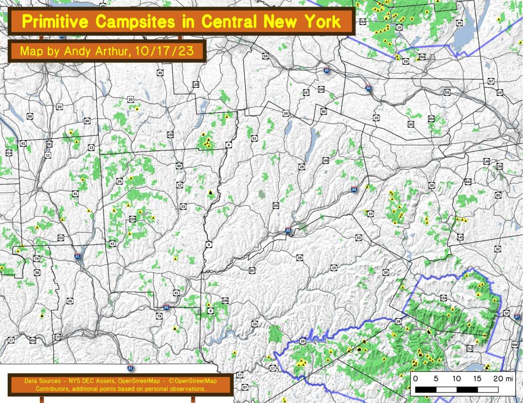
Bog River Flow – Popular canoe area that is popular for camping and paddling. Short portage between Hitchens Pond and Lows Lake. Lows Ledge is a 1 mile hike from the portage up to a ledge with expansive views of lakes and surrounding locations. Good to no cell service depending on location.

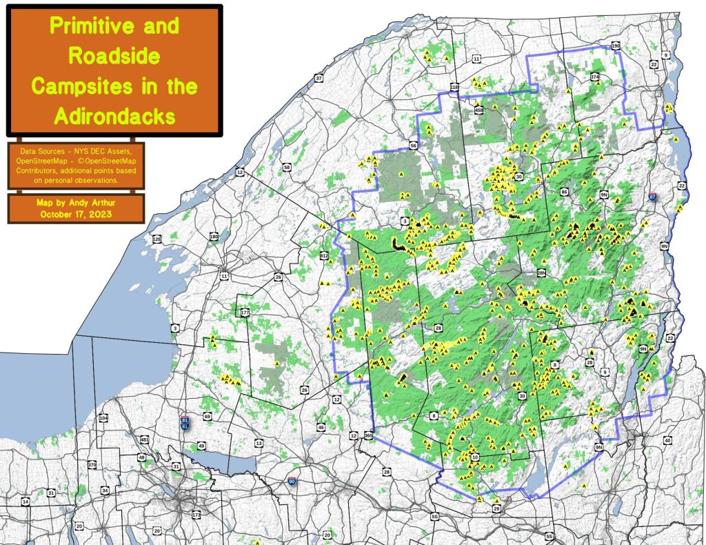
Brasher State Forest – Roughly 10 miles south of Malone, this expansive state forest is home to the Walter Pratt Camping Area on Red River Pond. Part of Saint Lawrence Flatlands, this area is largely sandy remote country with vast pine forest. Good cell service.

Chazy Lake – There are two campsites along the end of Wildfred Kingdom Road on Chazy Lake. The end of the road to the campsites is gated, and at times the campsites are marshy, but the views from the campsites are amazing.

Deer River State Forest – The “rough” country just north of Adirondack Park in Franklin County, that has camping in a wild environment that is the transition from the Adirondacks to the Saint Lawrence Flatland, about 10 miles outside of Malone. Limited cell service.

Franklin Falls Pond – There are several tent sites along the shore of Franklin Falls Pond that are a short hike down from the road and right along a popular canoe route. No cell service.

Floodwood Road (St Regis Canoe Area) – A very popular and packed in camping area is along Floodwood Road. I camped there once, I don’t recommend it.

Lake Kushaqua – A very scenic lake with a few campsites along it’s shore, near the Buck Pond Campground. I’ve been told these sites are too good to put out on the Internet and can be very hard to get in season. This lake connects with Rainbow Lake under a culvert, however to reach the upper part of Rainbow Lake you must portage.

Horsehoe Lake – Horseshoe Lake in Franklin County, is located about 15 miles south west of Tupper Lake. There are 6 campsites along the lake, plus 4 others on roads nearby. Near the Hitchens Pond put-in for Lows Lake, a popular spot for camping and paddling. Good to no cell service depending on location.

Mountain Pond – Old routing of NY 30 north of the Paul Smith VIC. Rough asphalt road. Near Barnum Pond which is very scenic for paddling, and rather rough Slush Pond Road which offers additonal campsites. No cell service.

Jones Pond – Three campsites located along a rough dirt road along with several tent sites along the north shore of this small lake about 10 miles from Saranac Lake.

Streeter Lake – Old railroad grade with 8 roadside campsites spread out along it’s way, along with a few campsites around the lake and an lean-to.

Union Falls Pond – One drive in site and a few tent sites along the reservoir just north of Franklin Falls Pond. Great views of Whiteface Mountain from this reservoir. No cell service.