Karner East 10 Foot Elevation
This map shows highly detailed contours for the East Barrens of the Albany Pine Bush.
Data Source: NYS GIS Program Office. NYS LIDAR Coverage. http://gis.ny.gov/elevation/lidar-coverage.htm
This map shows highly detailed contours for the East Barrens of the Albany Pine Bush.
Data Source: NYS GIS Program Office. NYS LIDAR Coverage. http://gis.ny.gov/elevation/lidar-coverage.htm
LEFT - 1952
RIGHT - 2020
Get the original on MapWarper, https://mapwarper.net/maps/44102
This map shows the 300 or so points in the Albany Pine Bush Study Area, that are above 325 feet in elevation and are a prominence around the surrounding land. The landfill is the highest peak at 432 feet above sea level, while Overlook Dune near the Albany Pine Bush Discovery Center tops out at 374 feet above sea level. The highest dune can be seen from the Traux Trailhead on Kings Road, which tops out 390 feet above sea level.
Data Source: Albany County LIDAR Digital Elevation Models. Dune peaks obtained by using the GRASS plugin in QGIS with r.param.scale, method=feature, then r.reclass to remove anything but value=6 to create peaks, then r.tovect to convert to vector areas, then used zonal statistics to find the maximum value on the peak, then extracted the centroids of the polygons.
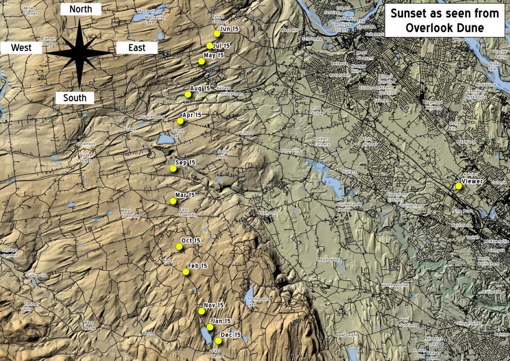
If you watch the sunset from Blueberry Hill or Overlook Dune in the Albany Pine Bush it will setting right over Horseshoe Clove at Thatcher Park this time of year. But come June, the sun will set north of Settles Hill.
This Google Map shows Albany Pine Bush soils that are found around the Pine Bush-area.
While roads and railroad tracks crossed the Albany Pine Bush in 1893, and parts of the area were farmed, most was still in tact Pine Bush.